

- Mountain ecosystems are the communities of plants, animals and people on steep, high and rugged terrain, where altitude, slope and aspect compress sharp changes in climate, soil and life into short distances.
- Mountains cover about 24% of the Earth’s land and feed most of the world’s great rivers; more than half of humanity depends on water that starts in the mountains.
- They are among the most fragile ecosystems on Earth. Gravity, young rocks, thin soils, a short growing season and an extreme climate mean that small disturbances trigger large, fast and often irreversible changes.
- Agenda 21 (1992) gave them a chapter of their own, Chapter 13, “Managing fragile ecosystems: sustainable mountain development”.
- The Himalaya, with the Hindu Kush and Karakoram, forms the Hindu Kush Himalaya (HKH): a 3,500-km arc across eight countries, called the “Third Pole” because it holds the largest store of ice outside the polar regions.
- The Indian Himalayan Region (IHR) runs about 2,500 km and covers over 5.3 lakh km² in 13 states and union territories.
- This highland of ice, forests and steep slopes sustains the lowlands of South Asia, and it is also a multi-hazard zone: landslides, glacial lake outburst floods, avalanches, cloudbursts, flash floods and earthquakes.
Mountain Ecosystems and Their Fragility

Altitudinal zonation: a stack of ecosystems
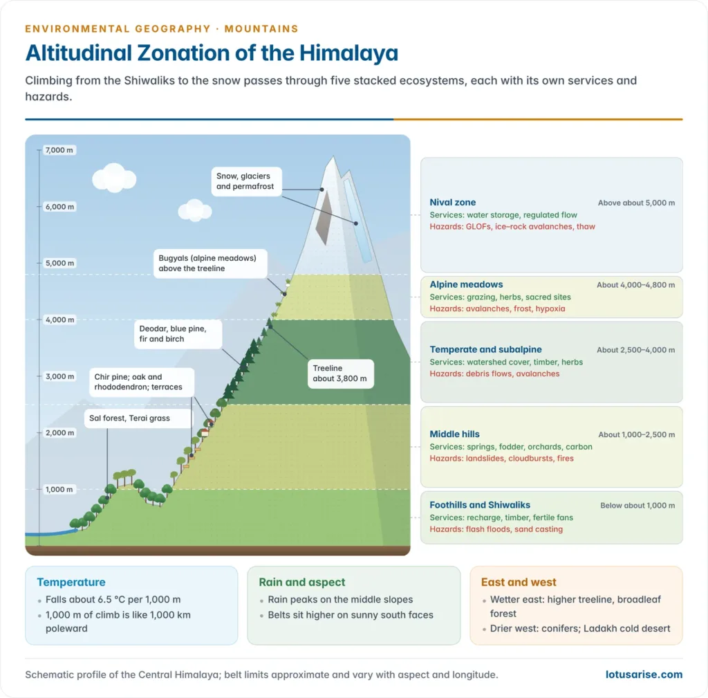
- Temperature falls with height at an average lapse rate of about 6.5 °C per 1,000 m. Climbing 1,000 m is roughly like moving 1,000 km or more towards the pole.
- So the belts of the mountain biome, tropical at the foot and tundra-like near the snowline, are squeezed into a few kilometres of height. Each belt is a distinct ecosystem with its own services and hazards.
- Other controls modify the belts:
- Rainfall rises with height through orographic lift to a zone of maximum precipitation on middle slopes, then falls.
- Aspect: sunny south-facing slopes are warmer and drier than shady north-facing ones, so belts sit higher on the sunny side.
- Longitude: the wetter Eastern Himalaya has higher treelines and richer broadleaf forests; the drier Western Himalaya has more conifers, and Ladakh beyond the Great Himalaya is a cold desert.
| Belt (approx., Central Himalaya) | Vegetation and land use | Key ecosystem services | Typical hazards |
|---|---|---|---|
| Foothills and Shiwaliks (below 1,000 m) | Sal forest, Terai grassland, irrigated rice and wheat | Groundwater recharge (bhabar), timber, fertile fans | Flash floods, river shifting, sand casting |
| Middle hills (1,000–2,500 m) | Chir pine, oak–rhododendron; terraces, orchards, towns | Springs, fodder, fuelwood, carbon, horticulture | Landslides, cloudbursts, forest fires |
| Temperate–subalpine (2,500–4,000 m) | Deodar, blue pine, fir, birch; summer pastures | Watershed protection, medicinal plants, timber | Debris flows, avalanches, slope failure |
| Alpine meadows (4,000–4,800 m) | Bugyals, cushion plants; transhumant grazing | Grazing, biodiversity, sacred and tourist landscapes | Avalanches, frost action, hypoxia |
| Nival (above about 5,000 m) | Snow, glaciers, permafrost | Water storage and regulated flow | GLOFs, ice–rock avalanches, permafrost thaw |
- Mountain agriculture follows the same zonation. The Himalayan ecosystem regulates cropping through temperature, slope, soil depth and water:
- Valleys and foothills: rice, wheat, maize and sugarcane on irrigated terraces and fans.
- Middle hills: rainfed maize, finger millet, barnyard millet, pulses and the mixed baranaja system of Garhwal; orchards of apple, pear and stone fruit.
- High valleys: barley, buckwheat, amaranth, potato and peas in one short summer season; saffron on the karewas of Kashmir.
- Above the treeline: only transhumant grazing by the Gaddi, Bakarwal and Bhotia.
- Jhum (shifting cultivation) dominates the north-eastern hills.
- Terracing, forest-derived manure, livestock and crop diversity are traditional forms of human ecological adaptation to slope and altitude, as in the yak-and-barley economy of the Sherpa and the pashmina herding of the Changpa.
- With warming, apple belts are shifting upslope in Himachal Pradesh, and erratic snowfall disturbs the chill hours that orchards need.
Why mountain regions are fragile
- Narpat S. Jodha (1992) of ICIMOD described six “mountain specificities” that set mountains apart from plains. Three are constraints and three are opportunities:
| Specificity | Meaning | Himalayan illustration |
|---|---|---|
| Inaccessibility | Slope, altitude and seasonal closure isolate places | Villages cut off by snow and landslides for months |
| Fragility | Low capacity to absorb disturbance; damage is fast and often irreversible | One road cut can destabilise a whole slope |
| Marginality | Remote from markets and power; low priority in planning | Outmigration and “ghost villages” in Uttarakhand |
| Diversity | Sharp variation over short distances | Rice to barley within 30 km |
| Niche | Unique products and services | Apple, saffron, medicinal herbs, hydropower, pilgrimage |
| Human adaptation | Indigenous practices fitted to the terrain | Terraces, transhumance, kuhl irrigation, Van Panchayats |
Physical fragility
- Gravity and slope: every particle is on a gradient, so soil, water and debris move downhill quickly, and any loss of cover is followed by erosion and mass movement.
- Young, rising and broken rocks: the Himalaya is a young fold mountain still rising through the India–Eurasia collision.
- Thrust faults (the Main Central, Main Boundary and Himalayan Frontal Thrusts) crush and shear the rock, and the whole arc lies in seismic zones IV and V.
- Thin, immature soils: they form slowly in the cold and are stripped quickly from slopes.
- Extreme and variable climate: intense monsoon bursts, snowfall and freeze–thaw cycles do a great deal of geomorphic work in a short time.
- The cryosphere (glaciers, snow, permafrost) responds to even small warming, and its loss sets off a chain of hazards.
Biological fragility
- Short growing season and low productivity: a damaged alpine meadow or subalpine forest may take decades to centuries to recover.
- Narrow belts and high endemism: species are confined to thin altitudinal bands and isolated peaks (“sky islands”), so endemism is high and populations are small.
- No room to move up: as the climate warms, species and treelines shift upslope. High-altitude specialists such as the pika, the snow leopard and many alpine plants run out of ground: an “escalator to extinction”.
- Sharp ecotones: many belts meet within short distances, so a disturbance in one quickly spreads to others.
- Low resistance and low resilience: mountain ecosystems resist disturbance poorly and recover slowly. A lowland forest clearing regrows within decades; a cleared Himalayan slope may lose its soil before trees can return, shifting to a degraded state of scrub, grass or bare rock.
Human and economic fragility
- Poverty, marginality and outmigration weaken the community labour that maintained terraces, springs and forests.
- External pressures come from the lowlands: roads, hydropower, mining, tourism and urban growth are planned for national demand, often without regard to slope stability.
Climate change amplifies fragility
- Elevation-dependent warming: many high mountains warm faster than the global average, so snow and ice respond sharply.
- The HKH Assessment (ICIMOD, February 2019), written by more than 200 scientists, found that about one-third of the region’s glaciers (about 36%) would be lost by 2100 even if global warming is held to 1.5 °C.
- Under high emissions, about two-thirds would go.
- The Water, Ice, Society and Ecosystems (HI-WISE) report (ICIMOD, 20 June 2023) found that:
- glaciers lost mass 65% faster in 2011–2020 than in the previous decade;
- they could lose 30–50% of their volume by 2100 at 1.5–2 °C, and up to 80% under high emissions;
- snow cover could fall by up to a quarter; permafrost is shrinking; and about 200 glacial lakes are considered dangerous.
- It judged 2 °C of warming the hard limit of adaptation for many mountain communities.
- The global warming signal therefore reaches the mountains first and hardest. This is why mountains are called sentinels of climate change.
Fragility beyond the Himalaya
- Western Ghats: an older, block-faulted range, but its steep western scarp, deep lateritic regolith and very heavy monsoon make it landslide-prone, and it is a global biodiversity hotspot with high endemism.
- The expert panel chaired by Madhav Gadgil (2011) proposed treating about 64% of the Ghats as ecologically sensitive. The working group under K. Kasturirangan (2013) narrowed this to about 37%, roughly 60,000 km².
- The Wayanad landslides (30 July 2024) showed how extreme rain on steep, saturated slopes becomes a disaster where villages sit in the debris-flow path below.
- Aravallis: among the world’s oldest ranges, worn low and degraded by mining and quarrying. They now need restoration more than protection alone.
- Other mountain regions show the same fragility:
- Andes: a moraine-dammed lake above Huaraz, Peru, burst on 13 December 1941, one of the deadliest GLOFs on record; tropical Andean glaciers are among the fastest-shrinking on Earth.
- Alps: the collapse of the Birch glacier buried most of the Swiss village of Blatten on 28 May 2025, after its people had been evacuated on the strength of monitoring.
- East Africa: the ice on Kilimanjaro has shrunk to a small fraction of its early twentieth-century extent.
- The common thread is the same everywhere: steep energy gradients plus warming plus human load make mountains react fastest to regional ecological change.
Himalayan Ecosystem Services and Highland–Lowland Linkages
Ecosystem services of the Himalaya
- Ecosystem services are the benefits people obtain from ecosystems. The Himalaya supplies all four categories, mostly to people who live far below it.
| Category | Himalayan services | Who benefits |
|---|---|---|
| Provisioning | Fresh water from snow, glaciers and springs; hydropower; timber, fodder and fuelwood; medicinal plants; horticulture; minerals | Hill communities; plains farms, cities and the power grid |
| Regulating | Seasonal water storage and release; climate regulation and carbon storage; erosion and flood control by forests; the barrier that shapes the monsoon and blocks cold winds | All of South Asia |
| Supporting | Sediment and nutrients that build the Indo-Gangetic plains and deltas; soil formation; habitats for four global biodiversity hotspots | Plains agriculture, delta and coastal ecosystems |
| Cultural | Pilgrimage (Char Dham, Amarnath, Kailash), tourism and mountaineering, sacred groves and peaks, indigenous knowledge | Pilgrims, tourists, the national economy |
- Water towers of Asia: the HKH feeds ten major river systems, among them the Indus, Ganga, Brahmaputra, Yangtze, Mekong and Amu Darya.
- About 240 million people live in the mountains, and about 1.65 billion in the river basins below; the rivers flow through 16 countries.
- Snow meltwater supplies up to about 40% of the Indus’s flow, and glacier melt sustains the dry-season flow of the Indus and upper Ganga when the plains need it most.
- Springs are the lifeline of the middle hills. A NITI Aayog working group (2018) reported that nearly half of the region’s perennial springs had dried or turned seasonal, because of land-use change, road cuts and erratic rain.
- Biodiversity: the region spans parts of four global biodiversity hotspots. ICIMOD estimates that 67% of its ecoregions and 39% of the hotspot area lie outside protected areas.
Highland–lowland linkages
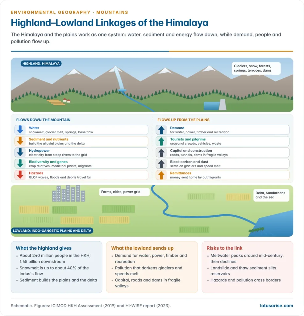
- The Himalaya and the plains form one coupled system. Matter, energy and people flow down from the mountains, and demands, capital and pollution flow up.
- Water: snow and ice store winter precipitation and release it in the dry season; forests and soils on slopes regulate runoff, reducing floods and sustaining base flow.
- Sediment and nutrients: the young Himalaya erodes fast. The Ganga–Brahmaputra system delivers of the order of a billion tonnes of sediment a year, building the alluvial plains, the delta and the Sundarbans.
- Energy: hydropower from Himalayan rivers feeds the national grid. Run-of-river and storage projects concentrate in the steepest, most seismic valleys.
- Biota and genes: wild relatives of crops, medicinal plants and migratory species link highland and lowland ecosystems.
- People: outmigration and remittances flow down; pilgrims, tourists, contractors and capital flow up.
- Pollution and demand: black carbon and dust from the Indo-Gangetic Plain settle on glaciers and darken the ice, speeding melt; lowland demand for water, power, timber and recreation reshapes mountain land use.
- Hazards travel downstream: the South Lhonak flood of October 2023 caused damage 385 km away, as far as Bangladesh.
- Highland–lowland sustainability in Asia depends on these flows staying regulated:
- Peak water: meltwater flow in the Indus, Ganga and other basins is projected to peak around mid-century and then decline. That threatens irrigation, cities and hydropower downstream.
- More sediment from landslides and thawing permafrost silts reservoirs and erodes turbines.
- Transboundary basins need shared data and cooperation, since rivers, floods and pollutants cross borders.
- A necessary caution: the Theory of Himalayan Environmental Degradation. In the 1970s and 1980s a popular theory held that hill population growth caused deforestation, then erosion, then catastrophic floods on the Ganga and Brahmaputra plains.
- Jack D. Ives and Bruno Messerli (The Himalayan Dilemma, 1989) showed that the evidence was weak.
- Monsoon rainfall and the natural erosion of a tectonically active range drive most lowland flooding and sedimentation.
- The effect of hill deforestation is strong in small catchments but diluted across large basins.
- The lesson: blame should not be shifted onto hill farmers. Highland–lowland policy must rest on measured data, not myths.
- Jack D. Ives and Bruno Messerli (The Himalayan Dilemma, 1989) showed that the evidence was weak.
High-Altitude Environmental Hazards
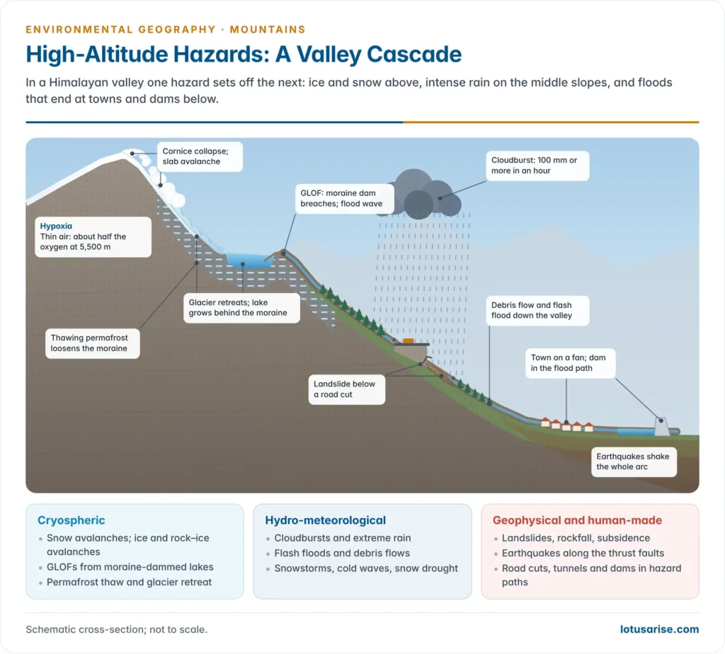
- A high-altitude environmental hazard is a natural or human-induced process in high mountains that threatens life, property and ecosystems. It arises from steep relief, the cryosphere, thin air and tectonic activity.
- The terms hazard, vulnerability, risk and resilience apply as anywhere. What marks mountains is the cascade: one hazard triggers the next, so that an avalanche becomes a debris flow and then a flood.
| Group | Hazards | Main drivers |
|---|---|---|
| Geophysical | Earthquakes, landslides, rockfall, land subsidence | Active tectonics, weak rocks, steep slopes |
| Cryospheric | Snow avalanches, GLOFs, ice and rock–ice avalanches, glacier surges, permafrost thaw | Snowfall, glacier retreat, warming |
| Hydro-meteorological | Cloudbursts, flash floods, extreme rain, snowstorms, cold waves, droughts in cold deserts | Monsoon and western disturbances, orography |
| Physiological | Hypoxia, acute mountain sickness, intense UV, frostbite, hypothermia | Thin air, cold, high radiation |
| Human-induced | Road-cut slides, tunnel and dam failures, forest fires, deforestation-led erosion | Construction, tourism, land-use change |
Why mountain hazards turn into disasters
- A hazard becomes a disaster only where people and assets are exposed and vulnerable. In the Himalaya several factors amplify vulnerability:
- Settlement on the wrong ground: flat land is scarce, so towns, hotels and roads crowd onto river terraces, alluvial fans and old landslide masses, exactly where floods and debris flows run.
- Seasonal crowding: the pilgrimage and tourist season coincides with the monsoon, multiplying the number of people in hazard zones.
- Single-road access: one blocked highway isolates whole valleys and delays rescue.
- Infrastructure in hazard paths: dams, barrages and tunnels in narrow gorges both suffer damage and add debris to floods.
- Weak data and warning: sparse rain gauges and glacier monitoring at high altitude, and poor communication in remote valleys.
Altitudinal and spatial pattern of hazards
- By altitude:
- Nival and glacial zone (above about 4,500 m): avalanches, GLOFs, ice–rock avalanches, permafrost thaw, hypoxia.
- Alpine and subalpine zone: snow avalanches, debris flows, frost shattering, blizzards.
- Middle hills: the densest settlement and the heaviest rain, hence landslides, cloudbursts, flash floods and forest fires.
- Foothills and Shiwaliks: flash floods from torrents (chos), river shifting, sand casting of fields.
- By region (along the longitudinal divisions of the Himalaya):
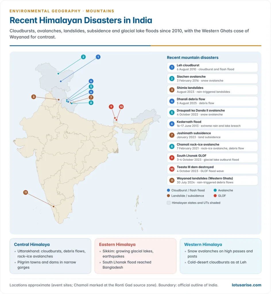
- Western Himalaya and Karakoram (Jammu and Kashmir, Ladakh, Himachal Pradesh): winter snowfall from western disturbances brings avalanches (Siachen, 3 February 2016: 10 soldiers killed); cold-desert cloudbursts (Leh, 6 August 2010: at least 255 deaths).
- Central Himalaya (Uttarakhand, Nepal): steep gorges, dense pilgrimage traffic and monsoon–western disturbance interaction make it the core of cloudbursts, landslides and GLOF-type floods (Kedarnath 2013, Chamoli 2021, Dharali 2025).
- Eastern Himalaya (Sikkim, Arunachal Pradesh, the north-east): the heaviest monsoon rain, high seismicity and growing glacial lakes bring landslides, earthquakes and GLOFs (Sikkim earthquake, 18 September 2011, M 6.9; South Lhonak, 2023).
Landslides and mass movement
- Landslides are the most frequent Himalayan hazard. Monsoon saturation, earthquakes, river undercutting and road cutting push slopes past their limit. Most Himalayan landslides are debris slides and debris flows in weathered regolith, rockfalls from jointed cliffs, and slow creep of old slide masses.
- A slide that blocks a gorge forms a landslide dam; its later breach releases a flood wave much like a GLOF.
- Mitigation: hazard zonation maps; surface and subsurface drainage; retaining and breast walls, rock bolting and wire netting; bioengineering with grasses and shrubs; controlled blasting and scientific muck disposal on roads; and rainfall-threshold early warning.
- The Landslide Atlas of India (NRSC–ISRO, 2023) mapped about 80,000 landslides between 1998 and 2022.
- About 0.42 million km² (12.6% of India’s area, excluding snow) is landslide-prone. About three-quarters of that lies in the north-eastern and north-western Himalaya, and most of the rest in the Western Ghats.
- Rudraprayag and Tehri Garhwal (Uttarakhand) ranked as the most landslide-exposed districts in India. Mizoram and Uttarakhand recorded the most events.
- The Western Ghats share the risk: the Wayanad landslides of 30 July 2024 in Kerala were not a Himalayan event.
- Land subsidence is the slow sinking of towns built on old landslide debris and loaded beyond capacity, as at Joshimath.
Glacier retreat and glacial lake outburst floods (GLOFs)
- As glaciers retreat, meltwater collects behind moraine dams or ice dams. These are loose, unsorted debris, sometimes with buried ice.
- A GLOF is the sudden release of such a lake when the dam fails. The glacial deposition and GLOF terms set out the landforms involved.
- Triggers: an avalanche, rockfall or moraine collapse into the lake that sends a wave over the dam; heavy rain; earthquakes; melting of buried ice; seepage and piping.
- Effects: a flood wave many times the normal peak, laden with boulders, that can travel hundreds of kilometres, destroying bridges, roads and dams.
- Types of glacial lakes: moraine-dammed lakes (the most dangerous), ice-dammed lakes, supraglacial ponds on the glacier surface, and erosion lakes in rock basins scoured by ice.
- Classic cases: the Dig Tsho outburst in Nepal’s Khumbu (4 August 1985) wrecked a nearly finished hydropower plant; Nepal later lowered Tsho Rolpa (2000) and Imja Tsho (2016) by about 3 m through outlet channels, the model for lake-lowering in India.
- India’s exposure: of about 7,500 glacial lakes in the Indian Himalaya, 189 high-risk lakes have been finalised under the National GLOF Risk Mitigation Programme, led by the NDMA.
- Its measures: bathymetry and modelling; automatic weather and water-level stations; early warning; lowering lake levels; and awareness downstream.
Snow avalanches
- An avalanche is a rapid flow of snow (often with ice, rock and debris) down a slope.
- Loose-snow avalanches start at a point; slab avalanches, the most dangerous, release a cohesive layer over a weak layer.
- Causes:
- Terrain: slopes of about 30–45°, convex profiles, gullies, no forest anchoring.
- Snowpack: heavy fresh snowfall, wind-loaded cornices, weak layers, rapid warming or rain-on-snow.
- Triggers: temperature rise, earthquakes, and human triggers such as skiers, climbers, blasting and vehicles.
- Indian cases: the Siachen avalanche (3 February 2016) at about 19,600 ft; the Draupadi ka Danda II avalanche (4 October 2022), which killed 27 trainees and instructors of the Nehru Institute of Mountaineering, with two never found.
- Avalanche-prone areas in India: Gulmarg, the Zoji La and Kupwara in Jammu and Kashmir; Lahaul–Spiti and Kinnaur in Himachal Pradesh; the upper Chamoli and Uttarkashi valleys in Uttarakhand; and the Nathu La road in Sikkim.
- Mitigation:
- Forecasting and warning: by the Defence Geoinformatics Research Establishment of the DRDO, which absorbed the Snow and Avalanche Study Establishment, Manali.
- Zoning: red, blue and white avalanche zones in land-use planning.
- Structures: snow fences and nets in the starting zone; deflecting walls and mounds in the track; snow galleries over roads.
- Bypass tunnels: the Atal Tunnel (2020) under the Rohtang Pass avoids an avalanche-prone road.
- Afforestation of starting zones, controlled triggering by explosives, and training and rescue preparedness.
Cloudbursts and flash floods
- A cloudburst is an extreme, localised downpour of 100 mm or more in an hour over a small area.
- It forms when moist monsoon air is forced rapidly up steep slopes (orographic lift), often when the monsoon meets a cold western disturbance.
- In narrow valleys the water turns within minutes into a flash flood or debris flow, which strikes settlements on river terraces and alluvial fans.
- “Cloudburst” is often a loose label. At Dharali (Uttarkashi, 5 August 2025), a debris flow down the Kheer Ganga buried much of the village on the Gangotri route.
- It was first blamed on a cloudburst. Scientists then weighed a glacier collapse, a lake outburst or a landslide, singly or together.
Earthquakes and permafrost thaw
- The Himalaya has produced great earthquakes: Kangra (1905), Bihar–Nepal (1934), Assam (1950), Kashmir (2005) and Gorkha, Nepal (25 April 2015, M 7.8).
- The 2015 quake triggered an avalanche that struck Everest base camp, and thousands of landslides.
- A long-unbroken stretch of the central arc, the central seismic gap, is thought to be storing strain for a future large event.
- Permafrost (ground frozen for two or more years) underlies high slopes and moraines in Ladakh, Lahaul–Spiti and Sikkim.
- As it thaws, frozen debris loses its “ice cement”, setting off rockfalls, debris flows and moraine collapses. Periglacial processes on such ground speed up.
Hydro-meteorological hazards in the Himalayas
| Hazard | Mechanism | Example |
|---|---|---|
| Cloudburst | Orographic convection; monsoon–western disturbance interaction | Leh (August 2010), Kedarnath (June 2013) |
| Flash flood and debris flow | Intense rain or outburst in a narrow, steep valley | Dharali (August 2025) |
| Extreme multi-day rainfall | Monsoon surge with a western disturbance | Himachal Pradesh (July–August 2023) |
| Riverine flood | Swollen rivers and landslide dams that later breach | Kedarnath (2013), Beas valley (2023) |
| GLOF | Moraine or ice dam fails | South Lhonak (October 2023) |
| Snow avalanche and blizzard | Heavy snowfall on steep slopes | Siachen (2016), Draupadi ka Danda II (2022) |
| Cold wave and frost | Cold air drainage, clear winter nights | Ladakh and upper valleys every winter |
| Drought and snow drought | Weak western disturbances; failing snowfall | Dry winters in Kashmir and Himachal |
| Forest fire | Dry, hot pre-monsoon on chir pine litter | Uttarakhand fire seasons |
| Lightning and hailstorms | Pre-monsoon convection | Orchard and crop damage |
Physiological hazards of high altitude
- Hypoxia: air pressure falls with height. At about 5,500 m each breath carries only about half the oxygen of sea level, and on Everest’s summit about a third.
- Acute mountain sickness is common above about 2,500 m on fast ascent. It can progress to life-threatening high-altitude pulmonary oedema and cerebral oedema.
- Cold and radiation: frostbite, hypothermia, snow blindness and sunburn from intense UV.
- Native highlanders cope through biological adaptations; visitors must acclimatise.
Recent Himalayan disasters: what they teach
| Event | Date | Hazard chain | Human factor |
|---|---|---|---|
| Kedarnath (Uttarakhand) | 16–17 June 2013 | Early, extreme monsoon rain with a western disturbance; Chorabari lake breach; debris flow down the Mandakini | Pilgrim towns and hotels on river terraces and fans |
| Chamoli (Uttarakhand) | 7 February 2021 | About 27 million m³ of rock and ice fell from Ronti peak; debris flow down the Rishiganga and Dhauliganga | Two hydropower projects in the flow path |
| Joshimath (Uttarakhand) | January 2023 | Subsidence of a town on old landslide debris | Unplanned load, poor drainage, slope cutting |
| Himachal Pradesh | July–August 2023 | Monsoon surge with a western disturbance; landslides, flash floods | Roads cut in weak slopes, building on floodplains |
| South Lhonak (Sikkim) | 3–4 October 2023 | Frozen moraine collapsed into the lake; outburst flood down the Teesta | Teesta III dam in the flood path |
| Dharali (Uttarakhand) | 5 August 2025 | Debris flow down the Kheer Ganga | Settlement on the stream’s fan |
- Kedarnath (2013): the Chorabari (Gandhi Sarovar) lake above the shrine breached on the morning of 17 June after days of extreme rain and snowmelt.
- Kedarnath, Rambara and Gaurikund were devastated, and more than 5,700 people were presumed dead by the state’s count.
- It showed the risk of concentrating pilgrims and buildings on debris fans and river terraces.
- Chamoli (2021): at 10:21 a.m., a mass of about 27 million m³ of rock and glacier ice fell some 3.7 km from Ronti peak.
- Its ice melted by friction into a debris flow that destroyed the Rishiganga hydropower project (13 MW) and struck the Tapovan–Vishnugad project (520 MW). 204 people were dead or missing.
- It was a winter event, not a GLOF: a reminder that slope instability above glaciers is a hazard in itself.
- Joshimath (2023): cracks appeared in hundreds of buildings (678 houses were declared unsafe by 9 January 2023).
- ISRO satellite data showed the town sank 5.4 cm in 12 days (27 December 2022 to 8 January 2023), against 8.9 cm in the seven months before.
- The Mishra Committee (1976) had warned that the town stands on old landslide debris in seismic zone V and had urged drainage, limits on construction and no tree felling.
- Himachal Pradesh (2023): a monsoon surge meeting a western disturbance brought the region’s heaviest rain in decades.
- The state recorded over 330 deaths from April and losses put at about ₹10,000 crore.
- Landslides in Shimla and washed-out roads in the Beas valley exposed construction on weak, steep slopes.
- South Lhonak (2023): the lake had grown from about 17 ha (1977) to about 167 ha (September 2023).
- About 14.7 million m³ of frozen moraine collapsed into it, raising a 20-m wave that breached the dam and released about 50 million m³ of water.
- The flood destroyed the Teesta III dam (1,200 MW) at Chungthang. At least 55 people died and more than 70 went missing.
- A 2025 study tied the collapse to glacier retreat and permafrost thaw.
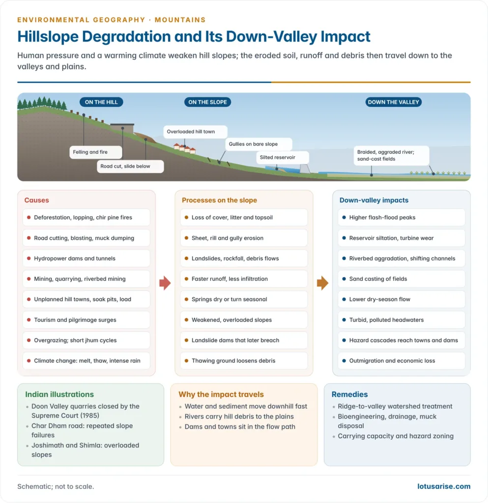
Degradation of Hills and Hillslopes
Causes of increasing degradation
- Deforestation and forest degradation: felling, lopping for fodder and fuelwood, and chir pine fires remove the cover that binds soil and feeds springs.
- Deforestation on steep slopes leads straight to sheet, rill and gully erosion.
- Road building and slope cutting: blasting and vertical cuts remove the toe of slopes; muck is dumped down the hillside.
- The Char Dham all-weather road, widened through fragile valleys (the Supreme Court allowed a wider carriageway on defence grounds in December 2021), has suffered repeated slope failures.
- Hydropower and tunnelling: dams, barrages and long tunnels fragment rivers, add blasting vibration, and place infrastructure in the paths of floods.
- Mining and quarrying: limestone quarrying in the Doon Valley stripped hillsides until the Supreme Court ordered quarries closed in the Rural Litigation and Entitlement Kendra case (1985).
- Riverbed mining for sand and boulders also destabilises banks.
- Unplanned urbanisation: hill towns such as Shimla, Mussoorie, Nainital and Joshimath have grown beyond their carrying capacity, with heavy buildings, soak pits and blocked drains on steep, saturated slopes.
- Tourism and pilgrimage: seasonal crowds, vehicles, hotels on riverbanks and waste outstrip local capacity.
- Agricultural pressure: cultivation of steep slopes without terracing, shortened jhum cycles in the north-east, and overgrazing of alpine meadows.
- Invasive species: Lantana camara and other weeds spread through degraded forests of the lower hills.
- Climate change: glacier retreat, permafrost thaw, more intense rain and drying springs act on slopes already weakened by these human causes.
- Human-induced slope failure belongs to the wider study of anthropogenic geomorphology.
Down-valley impact
- More and faster runoff: cleared, compacted slopes shed water quickly, raising flash-flood peaks and lowering dry-season flow.
- Sediment overload: soil erosion and landslides feed coarse debris into rivers.
- Reservoirs silt up and lose storage; turbines are abraded.
- Riverbeds aggrade, so channels braid and shift, as on the Kosi, and floods spread wider on the plains.
- Fields below the foothills are buried by sand (sand casting), as in the Kandi belt below the Shiwaliks.
- Water insecurity: dying springs and lower base flow hit hill villages first and lowland irrigation later.
- Water quality: turbid water, sewage and solid waste from hill towns and pilgrim centres pollute the Ganga headwaters.
- Hazard cascades travel down-valley: landslide dams that breach, debris flows and GLOF waves reach towns and dams tens to hundreds of kilometres away.
- Ecological loss downstream: fish breeding grounds silt up; riverine forests and wetlands are altered; deltas receive less sediment where dams trap it.
- Socio-economic loss: outmigration from degraded hills; flood relief, reconstruction and lost hydropower costs borne by the whole region.
Mountaineering, tourism and the threat to Everest
- Mount Everest (8,848.86 m), inside Nepal’s Sagarmatha National Park (a UNESCO World Heritage Site since 1979), shows how human pressure degrades even the highest ecosystems.
- How mountaineers threaten Everest:
- Crowding: a record 891 climbers summited in spring 2019. Long queues in the death zone helped bring 11 deaths in that season.
- Waste: discarded oxygen cylinders, tents, ropes, packaging and human waste at high camps. These do not decompose in the cold and seep into meltwater used downstream; microplastics have been found high on the mountain.
- Bodies: more than 200 bodies remain on the mountain, unrecoverable in the cold.
- Fuelwood and trekking pressure in the Khumbu: lodges, trail erosion and loss of juniper and rhododendron scrub.
- Exposure of workers: Nepali guides and porters bear most of the risk. An avalanche in the Khumbu Icefall killed 16 guides on 18 April 2014.
- Climate change thins the Khumbu Glacier under base camp, and officials have discussed moving the camp lower.
- Responses:
- permit limits and experience requirements (Nepal moved in 2025 to require a prior ascent of a 7,000-m Nepali peak);
- a refundable garbage deposit and army-led clean-up campaigns since 2019;
- local plastic bans; and
- carrying waste down from high camps.
- The same pressures act in the Indian Himalaya:
- Char Dham and Amarnath pilgrim surges; crowding in Manali, Shimla and Nainital;
- trekking waste on routes such as Roopkund; and
- vehicle traffic at the Rohtang Pass, which the National Green Tribunal capped.
- Green and eco-tourism with carrying-capacity limits, local ownership and waste management is the sustainable path for tourism in the mountains.
Responses: Towards Sustainable Mountain Development
International framework
- Agenda 21, Chapter 13 (1992): put mountains on the global agenda.
- International Year of Mountains (2002): led to the Mountain Partnership and International Mountain Day (11 December), observed since 2003.
- 2022 was the International Year of Sustainable Mountain Development. The UN declared 2023–2027 the Five Years of Action for the Development of Mountain Regions, and 2025 the International Year of Glaciers’ Preservation.
- ICIMOD (Kathmandu, 1983): the eight HKH countries’ intergovernmental centre, which runs the HKH Assessment and the HI-WISE reports.
- Global goals that touch mountains: SDG 15.4 (conservation of mountain ecosystems), the Sendai Framework for disaster risk reduction, and the Kunming–Montreal Global Biodiversity Framework.
India’s response
| Measure | Year | Focus |
|---|---|---|
| National Mission for Sustaining the Himalayan Ecosystem (NMSHE) | Mission document 2010; approved February 2014 | One of eight NAPCC missions; Department of Science and Technology; monitoring glaciers, forests, water and traditional knowledge |
| National Mission on Himalayan Studies | 2015–16 | MoEFCC; research and livelihood projects through the G. B. Pant National Institute of Himalayan Environment |
| SECURE Himalaya | 2017 | MoEFCC–UNDP–GEF; high-altitude landscapes in Ladakh, Himachal Pradesh, Uttarakhand and Sikkim; snow leopard habitat and livelihoods |
| Bhagirathi Eco-Sensitive Zone | 2012 | Gaumukh to Uttarkashi; limits on hydropower, mining and construction |
| NDMA guidelines | Landslides and avalanches 2009; GLOFs 2020 | Hazard zonation, early warning, regulation |
| National GLOF Risk Mitigation Programme | Surveys from 2024 | Survey and mitigation of 189 high-risk lakes |
| Landslide Atlas of India | 2023 | National landslide inventory and district exposure ranking |
- The Disaster Management (Amendment) Act, 2025, in force from 9 April 2025, strengthens national and state disaster plans and databases, including for mountain hazards.
- Hill-specific planning: hill area development strategies and special-category assistance recognise that hills cannot be developed like plains.
- Carrying capacity: in 2023 the Supreme Court took up the question of a carrying-capacity study for the Himalayan states and hill towns, after the Joshimath and Himachal disasters.
- Community institutions: the Van Panchayats of Uttarakhand (since 1931) and the Chipko movement (1973) show that local control protects forests and slopes.
Principles for sustainable mountain development
- Treat the mountain and the plain as one system: plan basins as wholes, through watershed management from ridge to valley and spring-shed management in the middle hills.
- Respect hazard geography: use hazard zonation and avoid building on debris fans, floodplains, old landslides and avalanche tracks; enforce slope-specific building codes.
- Build infrastructure that fits the slope: tunnels, ropeways and slope-stabilised roads with muck disposal, drainage and bioengineering; cumulative impact assessment of dams and hydropower cascades in a basin.
- Watch the cryosphere: monitor glaciers, glacial lakes and permafrost; issue early warnings downstream and share data across borders.
- Regulate tourism by carrying capacity: permits, waste management, homestays and eco-tourism.
- Value and pay for ecosystem services: compensate hill communities that protect forests, springs and watersheds for downstream users.
- Revive indigenous knowledge: terraces, kuhls, transhumance, crop diversity and community forests.
- Restore degraded slopes: afforestation with native broadleaf species, check dams and bioengineering. These link to wider ecosystem management and restoration.
Previous Year Questions
2025How does Himalayan ecosystem regulate the cropping pattern and agricultural activities in Himalayan region of India? Discuss.2024Mountain regions are more fragile to ecological changes. Elucidate.2024Discuss the variations in nature of glaciers in India and the emerging issues due to climate change.2022What are the high altitude environmental hazards ? Explain with suitable examples.2021Describe how ecosystem services of Himalaya are essential for Highland-Lowland sustainability in Asia.2020Avalanche is a major hazard in the Himalayas. What are its causes and mitigation measures ?2019How do mountaineers constitute a threat to Mount Everest?2019Describe the altitudinal and spatial geo-environmental hazards in the Himalayas.2019Explain the relevance of green tourism for sustainable development of mountain environment in India.2018“Geomorphological changes are largely responsible for environmental hazards in the Himalayan region.” Comment with relevant examples.2016Explain the hydro-meteorological hazards in the Himalayas.2014Enumerate the major causes of increasing degradation of environment in hills and hillslopes, and state its down-valley impact.




