In this article, You will read about Landslide: Types, Causes, Impact & Remedial steps for UPSC IAS Exam.
Landslide
Natural Hazards
- A hazard is a dangerous condition or threat, natural or man-made that can cause injury, loss of life, or damage to property, livelihood, and environment.
- Natural Hazards may be grouped under the following 2 major categories
- Geological Hazards – Earthquakes, Volcanoes, Tsunami, Landslides, and Avalanches.
- Weather associated Hazards – Cyclones, Thunderstorms, Droughts, Floods and epidemics.
- It has been estimated that the world endures on an average about lakhs of thunderstorms, thousands of floods, hundreds of landslides and earthquakes, and scores of the cyclone and volcanic eruptions every year.
- Natural Disaster versus Natural Hazard – A natural hazard is a threat of a naturally occurring event that will have a negative effect on humans. This negative effect is what we call a natural disaster. In other words, when the hazardous threat actually happens and harms humans, we call the event a natural disaster.
Introduction to Landslides
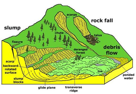
- Landslide is a rapid movement of rock, soil, and vegetation down the slope under the influence of gravity. It may be induced by natural agencies, e.g., heavy rain, earthquake, or it may be caused by human over- interference with the slope – stability.
- Man breaks rocks for constructing roads, railways, buildings, tunnels, etc. In such cases rocks become loose and landslide occurs.
- Earth flow, mass movement, mudflow, rotational slip, and avalanches are all examples of landslides.
- Landslides are rarely on a scale comparable to seismic or volcanic events. The intensity and magnitude of the landslide, however, depends on the geological structure, angle of dip of the slope, nature of sedimentary rocks, and the human interaction with the slope.

Landslide Dam
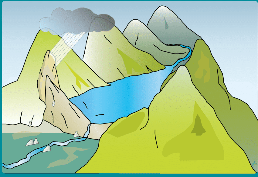
When landslides occur on the slopes of a river valley, the sliding mass may reach the bottom of the valley and cause partial or complete blockage of the river channel. This accumulated mass of landslide debris resulting in the blockage of a river is commonly termed as a Landslide dam.

Types of landslides
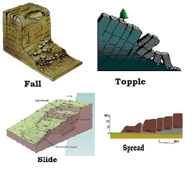
1. Falls: It happens due to the abrupt movements of masses of geologic materials, such as rocks and boulders that become detached from steep slopes or cliffs.
2. Topples: It happens due to the forward rotation of a unit or units about some pivotal point, below or low in the unit, under the actions of gravity and forces exerted by adjacent units or by fluids in cracks
3. Slides: In this types, rocks, debris or soil slide through slope forming material.
4. Spread: It usually occur on very gentle slopes or flat terrain.

Causes of Landslides
The major causes of landslides are –
1. Rainfall and Snowfall-
- The occurrence of heavy or continuous rainfall may lead to heavy landslides in the areas of steep slopes where National Highways and roads have been constructed.
- The Nashri area between BatoteRamban- Ramsu, and Banihal (Jammu and Kashmir) is frequently subjected to landslides. The landslides in this region are particularly severe during the rainy and winter seasons when the vehicular traffic is disturbed for several days.
2. Earthquakes and Volcanic Eruptions-
- Earthquakes are the most important cause of landslides in the folded mountainous areas. In India, Landslides are more frequent in the folded mountains of the Tertiary Period, like the Himalayas.
- In the Kashmir valley, the earthquake of 1905 resulted into landslides in the lesser and the Greater Himalayas in which several thousand people lost their lives.
- Volcanic eruptions also trigger landslides in the mountainous regions.
3. Mining, Quarrying and Road cutting-
- The continuous extraction of coal, minerals, and stones from the mines and quarries and the development of roads by cutting the steep slopes in the folded mountains create conducive conditions for the occurrence of landslides.
- Such landslides may be observed throughout the Himalayas and in the Eastern and Western Ghats.
4. Loading by construction of houses-
- The unplanned growth of towns and cities in the hilly areas without testing soil and rocks in also an important cause of landslides.
- The eastern slope of Nanital (Uttarakhand) is sinking because of the heavy load of hotels and residential structures.
5. Deforestation-
- Deforestation and other human activities also induce landslides. Most of the landslides are small involving some blocks up to a few meters across. But some are large enough to cause a catastrophe. They may bury roads, buildings, and other structures.
- The adverse effect of landslides can be reduced by checking deforestation on mountain slopes, following building codes for such areas, and by avoiding the construction of buildings on steep slopes.
Impact of Landslides
| Short Term Impacts | Long Term Impacts |
| Loss of Lives and Properties | Changes in the landscape that can be permanent |
| Roadblocks, destruction of railway lines | Loss of cultivable land |
| Channel blocking due to rock – falls | Environmental impact in terms of erosion and soil loss |
| Diversion of river courses due to landslides causing floods | Population shift and relocation of populations and establishments |
| Loss of natural Beauty | Drying up of sources of water |
Vulnerability profile of India
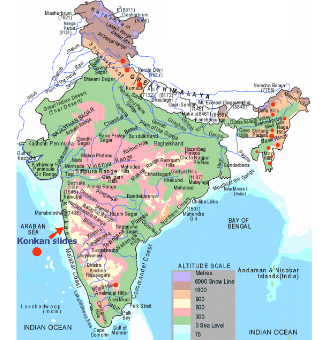
In India, this hazard affects at least 15% of the land area of the country ( approx 0.49 million square Km.) It is very frequent in geodynamical active domains in the Himalayan and Arakan- Yoma belt of the Northeastern parts of the country as well as in the relatively stable domains of the Meghalaya Plateau, Western Ghats, and Nilgiri Hills.
The Nilgiri Hills located at the convergence of Eastern and the Western Ghats bear the innumerable scars of the landslides due to their location in a zone of high intensity and protracted rainfall where the overburden is sensitive to over-saturation.

Mitigation Strategy
- Hazard zones have to be identified and specific slides to be stabilized and managed in addition to monitoring and early warning systems to be placed at selected sites.
- Hazard mapping should be done to locate areas commonly prone to landslides. It is always advisable to adopt area-specific measures to deal with landslides.
- Restriction on the construction and other developmental activities such as roads and dams, limiting agriculture to valleys and areas with a moderate slope, and control on the development of large settlements in high vulnerability zones, should be enforced.
- NDMA Guidelines for Landslides –
- Landslide Hazard, vulnerability and Risk Assessment
- Multi – Hazard Conceptualisation
- Landslide Remediation practice
- Research and Development, monitoring, and early warning
- Knowledge network and management
- Capacity building and Training
- Public awareness and Education
- Emergency preparedness and response
- Regulation and Enforcement

awesome