

- An earthquake is a sudden shaking of the ground caused by the abrupt release of strain energy stored in the rocks of the lithosphere; the energy spreads outward from the point of release as seismic waves.
- It is a transient disturbance of the elastic or gravitational equilibrium of rocks, ranging from a faint tremor to motion violent enough to split the ground and bring buildings down.
- Earthquakes are the most visible expression of endogenic (tectonic) forces, and most are generated by movement along faults at plate boundaries; volcanic activity, isostatic adjustment and human activity add a smaller share.
- Minor tremors are recorded every few minutes somewhere on Earth, but the rare large events are among the most unpredictable and destructive natural hazards, especially in densely populated, poorly built areas.
Earthquake: Basic Concepts and Measurement
Focus and Epicentre
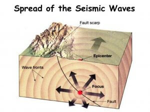
- The focus or hypocentre is the point inside the Earth where rupture begins and energy is first released.
- Focal depth ranges from near the surface to about 700 km; the deepest foci lie in slabs sinking into the mantle.
- Most Himalayan earthquakes are shallow, with foci at about 10–30 km on the thrust faults beneath the range.
- The epicentre is the point on the ground surface vertically above the focus; it is reached first by the waves and usually shaken hardest.
- Shaking generally decreases with distance from the epicentre; lines joining places of equal intensity are isoseismal lines.
- The seismograph records ground motion as a seismogram; the science of earthquakes and seismic waves is seismology.
Seismic Waves in Brief
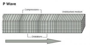
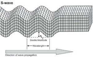
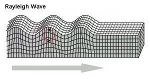
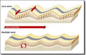
- An earthquake sends out two groups of seismic waves: body waves (P and S), which travel through the Earth’s interior, and surface waves (Love and Rayleigh), which travel along the surface and do most of the damage.
| Wave | Particle motion | Travels through | Speed and arrival | Damage |
|---|---|---|---|---|
| P (primary) | Push–pull along the path (longitudinal) | Solids, liquids, gases | Fastest; arrives first | Low |
| S (secondary) | At right angles to the path (transverse) | Solids only | About 60% of P speed; arrives second | Moderate |
| Love | Side to side, horizontal | Surface layers | Fastest surface wave | High |
| Rayleigh | Rolling, elliptical (up–down and forward) | Surface layers | Slowest; arrives last | Highest; most felt shaking |
- Body waves: P waves compress and stretch the rock like sound in air; S waves shear it and cannot cross a liquid.
- Surface waves: Love waves, named after Augustus Edward Hough Love, shake the ground sideways; Rayleigh waves, named after Lord Rayleigh (John William Strutt), roll the ground like ocean swell and carry the largest amplitudes.

Measuring Earthquakes: Magnitude and Intensity
Magnitude: Richter and Moment Magnitude Scales
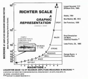
- Magnitude measures the energy released at the source; one earthquake has one magnitude, wherever it is recorded.
- The Richter scale was devised by Charles Francis Richter (1935), working with Beno Gutenberg, from the maximum wave amplitude on a standard seismograph.
- It is logarithmic: each whole number means 10 times the ground-motion amplitude and about 32 times the energy.
- It is open-ended, with no upper limit; the familiar “0 to 9” is only the range observed so far.
- It was built for local Californian shocks and saturates above about magnitude 7, underestimating great earthquakes.
- The moment magnitude scale (Mw) of Thomas C. Hanks and Hiroo Kanamori (1979) is now the standard for large events.
- It is based on the seismic moment: rock rigidity × area of the fault that slipped × average slip.
- It does not saturate; the largest earthquake recorded is Chile 1960 (Mw 9.5).
- Different scales explain why early figures for one event differ: the Bhuj earthquake of 2001 was first reported at 6.9 by one agency and 7.9–8.1 by others; its accepted size is Mw 7.7.
- Energy is concentrated in a few great earthquakes: small shocks are far more numerous, but each step of magnitude releases about 32 times more energy, so the few earthquakes above magnitude 7 release most of the world’s yearly seismic energy.
- The Chile 1960 earthquake alone released roughly a quarter to a third of all seismic energy of the 20th century.
Intensity: Mercalli and MSK Scales
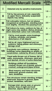
- Intensity measures the effects of shaking at a given place: what people felt, and what happened to buildings and the ground.
- One earthquake has many intensities, falling with distance and varying with local geology and construction.
- The Mercalli scale of Giuseppe Mercalli (1902) was expanded to twelve grades and revised as the Modified Mercalli Intensity (MMI) scale by Harry O. Wood and Frank Neumann (1931).
- It runs from I (not felt) to XII (total destruction) and is written in Roman numerals.
- India’s zoning uses the comparable Medvedev–Sponheuer–Karnik (MSK-64) scale, also of twelve grades.
| Basis | Magnitude | Intensity |
|---|---|---|
| Measures | Energy released at the focus | Effects of shaking at a place |
| Values per earthquake | One | Many (maps as isoseismals) |
| Scales | Richter (ML), moment magnitude (Mw) | Modified Mercalli, MSK-64 |
| Numbers | Arabic, logarithmic, open-ended | Roman, I–XII, descriptive |
| Depends on | Fault area and slip | Distance, depth, ground, buildings |
- Indian example: the Bihar–Nepal earthquake of 1988 was of moderate magnitude, yet soft, water-saturated Gangetic alluvium amplified the shaking and raised intensities across north Bihar, damaging tens of thousands of houses.
| Magnitude | Class | Typical effect |
|---|---|---|
| Below 4.0 | Minor | Felt, rarely damaging |
| 4.0–4.9 | Light | Rattling, slight damage |
| 5.0–5.9 | Moderate | Damage to weak buildings |
| 6.0–6.9 | Strong | Destructive over tens of km |
| 7.0–7.9 | Major | Serious damage over large areas |
| 8.0 and above | Great | Destruction over hundreds of km |
Causes of Earthquakes
- An earthquake occurs whenever stress disturbs the equilibrium of crustal rocks faster than they can adjust; the disturbance may come from faulting, plate motion, magma, isostatic readjustment or human loading.
- The old idea that stable, isostatically balanced shields are immune was disproved by Koyna (1967) and Latur (1993) in the Deccan: no region is entirely free of seismic risk.
- Older explanations also invoked gaseous expansion and contraction inside the Earth; modern seismology explains almost all large earthquakes by fault slip.
Faulting and the Elastic Rebound Theory
- Proponent: Harry Fielding Reid (1910), one of the investigators of the San Francisco earthquake of 18 April 1906, published the elastic rebound theory.
- Assumptions:
- Rocks are elastic: under stress they bend and store energy, like a stretched rubber band.
- Two blocks on either side of a fault are driven in opposite directions by slow, continuous tectonic movement, but friction locks the fault.
- Mechanism (the earthquake cycle):
- Strain accumulates for decades to centuries as the locked blocks deform.
- When stress exceeds the frictional strength of the fault, it ruptures suddenly.
- The deformed blocks snap back (rebound) towards an unstrained shape in seconds, offsetting features that cross the fault.
- The stored energy radiates as seismic waves; aftershocks follow as the surrounding crust readjusts, and strain begins to build again.
- Evidence: survey lines across the San Andreas Fault showed bending over the decades before 1906; fences and roads were then offset by several metres along a rupture more than 400 km long.
- Indian examples: the Bihar–Nepal (1934), Assam (1950) and Bhuj (2001) earthquakes were produced by slip on faults; in the Deccan, buried rift faults beneath the basalts are linked to the Koyna and Bhatsa seismicity.
- Evaluation:
- GPS and satellite radar (InSAR) now measure strain building across faults, which strongly supports Reid’s model.
- Recurrence is irregular, so the model explains how but not when; stress transferred from neighbouring ruptures can bring a fault forward or delay it.
- It does not explain deep-focus earthquakes (below about 300 km), where rocks should flow rather than break; these are attributed to mineral phase changes and dehydration in sinking slabs.
Plate Movements
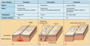
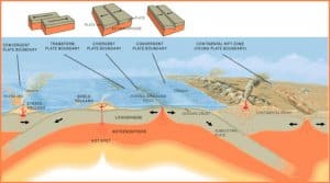
- Plate tectonics is the most complete explanation of where and why earthquakes occur: most epicentres lie on plate boundaries, where plates separate, collide or slide past each other.
| Boundary | Motion and stress | Focal depth | Size | Examples |
|---|---|---|---|---|
| Divergent (constructive) | Plates pull apart; tension, normal faults, rising magma | Shallow (mostly under 30 km) | Moderate | Mid-Atlantic Ridge, Carlsberg Ridge, East African Rift |
| Convergent (destructive) | Collision and subduction; compression, thrusts | Shallow to deep (to about 700 km) | Largest | Chile 1960, Sumatra 2004, Japan 2011, Nepal 2015 |
| Transform (conservative) | Plates slide past; shear, strike-slip faults | Shallow | Strong, destructive on land | San Andreas, North Anatolian, Türkiye 2023, Myanmar 2025 |
- At subduction zones, foci deepen towards the overriding plate along an inclined belt, the Wadati–Benioff zone, which traces the sinking slab into the mantle.
- The world’s great megathrust earthquakes (Mw 9 and above) all occur here.
- In the Himalaya, the Indian plate is thrust beneath the Eurasian plate along the Main Himalayan Thrust; the convergence of roughly 4–5 cm a year, partly absorbed across the range, loads the faults that produce great Himalayan earthquakes.


Intraplate Earthquakes
- Some damaging earthquakes occur far from plate boundaries, inside plates: New Madrid, USA (1811–12), Charleston, USA (1886), and in India Kutch (1819), Koyna (1967), Latur (1993), Jabalpur (1997) and Bhuj (2001).
- Plate tectonics explains them only indirectly: compressive stress transmitted through the plate reactivates old zones of weakness, such as ancient rifts.
- The Bhuj earthquake occurred on a reverse fault in the old Kachchh rift, some 300–400 km from the plate boundary.
- Rift-associated shocks of the Indian shield: Bhadrachalam (1969) in the Godavari graben and Broach (Bharuch, 1970) in the Narmada rift.
- Beneath the Deccan basalts, buried rift structures and lineaments, such as the Kurduwadi lineament of Maharashtra, are held responsible for recurring tremors in the Deccan.
Volcanic Activity
- Vulcanicity and earthquakes act as cause and effect of each other: rising magma and expanding gases fracture the crust, and large earthquakes can open paths for magma.
- Swarms of small tremors are a leading precursor of eruptions and are monitored for warning.
- Volcanic earthquakes are generally local and of modest magnitude, their size depending on the violence of the eruption; the catastrophic exception is Krakatoa (1883), whose explosion generated tsunamis that killed about 36,000 people on Java and Sumatra.
Isostatic Adjustment
- When load is added to or removed from the crust, it readjusts to regain isostatic balance, and the readjustment can trigger earthquakes.
- Post-glacial rebound in Fennoscandia and northern Canada, where land is still rising after ice-sheet melting, is accompanied by earthquakes.
- Rapid uplift and erosion of young fold mountains such as the Himalaya keep them isostatically unstable.
Human-Induced Earthquakes
- Human activity can trigger or induce earthquakes by changing stress or fluid pressure on faults that are already close to failure.
Reservoir-Induced Seismicity (RIS)
- Reservoir-induced seismicity is earthquake activity triggered by the impounding of large reservoirs behind dams.
- Mechanism:
- The weight of water adds load on the rocks beneath.
- More importantly, water seeps down fractures and raises pore-water pressure, which reduces the friction clamping a fault, so it slips more easily.
- Seismicity often tracks the filling and draining cycle of the reservoir.
- Koyna, Maharashtra: the reservoir was impounded in 1962; the M 6.3 earthquake of 11 December 1967 killed about 180 people and is the largest known reservoir-triggered earthquake.
- Hundreds of small shocks still occur each year beneath the Koyna and Warna reservoirs; a scientific borehole about 3 km deep has been drilled there to study the fault zone.
- World examples: Marathon Dam, Greece (tremors from 1931); Lake Mead behind Hoover Dam, USA (from 1936); Kariba (Zambia–Zimbabwe), Kremasta (Greece) and Nurek (Tajikistan).
- Indian concern: seismicity near Bhatsa (Maharashtra) and the safety of high dams such as Tehri in Zone V–VI terrain.
Other Human Causes
- Deep mining: rock bursts, as in the old Kolar Gold Fields, Karnataka.
- Fluid injection and extraction: wastewater injection in Oklahoma, USA; gas extraction at Groningen, Netherlands; an enhanced geothermal project linked to the Pohang, South Korea earthquake (2017, Mw 5.5); pumping of groundwater and oil.
- Explosions: underground nuclear tests and large-scale blasting for dams, roads and tunnels.
- Induced earthquakes are usually small, but they occur in places not designed for shaking.
Classification of Earthquakes
| Basis | Classes | Notes and examples |
|---|---|---|
| Cause: natural | Tectonic, volcanic, isostatic, plutonic | Tectonic are the most frequent and destructive (San Francisco 1906, Bhuj 2001) |
| Cause: human | Anthropogenic or induced | Koyna 1967, Pohang 2017 |
| Focal depth (classical, Beno Gutenberg) | Moderate 0–50 km; intermediate 50–250 km; deep 250–700 km | Plutonic = deep-focus |
| Focal depth (current usage) | Shallow 0–70 km; intermediate 70–300 km; deep 300–700 km | Shallow ones cause most damage |
| Human casualties | Moderately hazardous (under 50,000 deaths); highly hazardous (50,000–1,00,000); most hazardous (over 1,00,000) | See table below |
- Tectonic earthquakes result from slip on faults and are by far the most common and damaging.
- Volcanic earthquakes are confined to volcanic regions.
- Isostatic earthquakes follow regional imbalance, especially in active mountain belts.
- Plutonic earthquakes are the deep-focus events, with foci roughly 250–700 km down in subducting slabs.
- Shallow-focus earthquakes concentrate energy near the surface, so a shallow M 6 can do more damage than a deep M 7.
| Casualty class | Deaths | Examples |
|---|---|---|
| Moderately hazardous | Under 50,000 | Latur 1993 (about 9,700), Nepal 2015 (about 9,000), Bhuj 2001 (about 20,000) |
| Highly hazardous | 50,000–1,00,000 | Kashmir 2005 (about 86,000), Türkiye–Syria 2023 (over 59,000) |
| Most hazardous | Over 1,00,000 | Shaanxi, China 1556 (about 8,30,000), Tangshan, China 1976 (officially about 2,42,000), Sumatra–Andaman 2004 (about 2,27,000, mostly by tsunami) |
Distribution of Earthquakes
World Distribution of Earthquakes
- Earthquakes are concentrated in narrow belts, closely matching the distribution of volcanoes, in:
- zones of young fold mountains;
- zones of faulting and fracturing;
- junctions of continental and oceanic crust;
- zones of active volcanoes;
- above all, along plate boundaries.
| Belt | Share of largest earthquakes | Tectonic setting | Examples |
|---|---|---|---|
| Circum-Pacific (“Ring of Fire”) | About 81% | Subduction of Pacific-floor plates beneath the Americas, Asia and island arcs | Chile 1960, Alaska 1964, Mexico City 1985, Japan 2011, Kamchatka 2025 |
| Alpine–Himalayan (Alpide, Mid-Continental) | About 17% | Collision of African, Arabian and Indian plates with Eurasia | Kashmir 2005, Nepal 2015, Türkiye–Syria 2023, Myanmar 2025 |
| Mid-Atlantic and other ridges | Small share | Divergence, transform faults, fissure eruptions | Iceland, Azores |
| Intraplate and rift zones | Small share | Old weak zones, rifts | East African Rift, New Madrid, Latur |
- The Circum-Pacific belt combines all the conditions for earthquakes: continent–ocean junctions, young fold mountains (Rockies, Andes), active volcanoes and subduction zones.
- The Mexico City earthquake of 1985 showed how soft lake-bed sediments amplify distant shaking, killing about 10,000 people.
- The Alpine–Himalayan belt runs from the Alps and the Mediterranean through Türkiye and Iran to the Himalaya and the Myanmar arc; its earthquakes are shallow and destructive because they occur beneath populated continental land.
- Deep earthquakes (below about 100 km) occur almost only at convergent margins, where they mark the subducted plates.
Earthquakes in India
Seismic Regions of India
- Himalayan region: the zone of highest seismic activity, where the collision of the Indian and Eurasian plates continues along the Main Himalayan Thrust and its branches (Main Central Thrust, Main Boundary Thrust, Himalayan Frontal Thrust).
- The belt continues through the Sulaiman–Kirthar ranges in the west and the Myanmar (Burmese) arc in the east, with the Shillong plateau and north-east India among the most active parts.
- A central seismic gap between Uttarakhand and western Nepal has had no great earthquake for about two centuries, so strain is believed to be accumulating there.
- Indo-Gangetic plains: moderate activity, but thick soft alluvium amplifies shaking from Himalayan earthquakes, and the plains are densely populated.
- Peninsular shield: long considered stable, but it carries intraplate earthquakes on old rifts and faults (Koyna, Latur, Jabalpur, Kutch); the Narmada–Son and Kachchh rifts are the chief weak zones.
- Andaman–Nicobar arc: a subduction zone where the Indian plate sinks beneath the Burma microplate; source of the 2004 earthquake.
| Year | Earthquake | Magnitude | Significance |
|---|---|---|---|
| 1819 | Rann of Kutch | About Mw 7.7–8.2 | Raised the Allah Bund scarp; Sindri fort sank |
| 1897 | Shillong (Great Assam) | Mw 8.0 | Surface faulting, liquefaction across Assam |
| 1905 | Kangra | About 7.8 | Over 20,000 deaths |
| 1934 | Bihar–Nepal | Mw 8.0 | About 10,000 deaths; widespread liquefaction |
| 1950 | Assam–Tibet | Mw 8.6 | Largest in India; landslide-dammed rivers |
| 1967 | Koyna | M 6.3 | Reservoir-triggered, about 180 deaths |
| 1991 | Uttarkashi | Mw 6.8 | About 770 deaths |
| 1993 | Latur | Mw 6.2 | About 9,700 deaths in a “stable” shield |
| 1999 | Chamoli | Mw 6.6–6.8 | About 100 deaths |
| 2001 | Bhuj | Mw 7.7 | About 20,000 deaths; intraplate |
| 2004 | Sumatra–Andaman | Mw 9.1–9.3 | Tsunami on Tamil Nadu and Andaman coasts |
| 2005 | Kashmir | Mw 7.6 | About 86,000 deaths, mostly across the LoC |
| 2011 | Sikkim | Mw 6.9 | Landslides, damage to Teesta hydro projects |
| 2016 | Imphal, Manipur | Mw 6.7 | North-east arc |
- The Calcutta disaster of 11 October 1737, long listed as India’s deadliest earthquake with 3,00,000 dead, is now regarded as a severe cyclone and storm surge.
- Contemporary records give about 3,000 deaths in a town of roughly 20,000, and there is no reliable evidence of a major earthquake (Roger Bilham, 1994).
Seismic Zoning of India
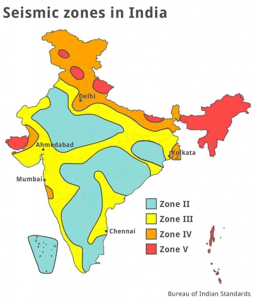
- The Bureau of Indian Standards (BIS) zones the country in its earthquake design code, IS 1893 (Part 1), which sets how strongly buildings must resist shaking in each zone.
- 2016 code (in force): four zones, II, III, IV and V; the old Zone I was merged into Zone II in 2002.
- About 59% of the land area was classed as prone to moderate or higher shaking.
- 2025 revision and its withdrawal: BIS notified IS 1893 (Part 1): 2025 on 6 November 2025. It was based on Probabilistic Seismic Hazard Assessment (PSHA), which models active faults and their rupture potential instead of relying mainly on past epicentres.
- It added a new Zone VI (highest hazard) for the entire Himalayan arc and the Andaman–Nicobar Islands.
- The notification was withdrawn in March 2026, so the 2016 map with Zones II–V remains in force. The hazard science behind the revision, above all the seismic gap along the central Himalaya, still stands.
| Zone | Hazard (MSK intensity) | Typical areas |
|---|---|---|
| II | Low (VI or less) | Much of the peninsular interior |
| III | Moderate (VII) | Kerala, Goa, parts of peninsular and central India |
| IV | High (VIII) | Delhi, Indo-Gangetic plains near the Himalaya, parts of Himachal and Uttarakhand |
| V | Very high (IX and above) | North-east, Kashmir, parts of Himachal and Uttarakhand, Rann of Kutch, north Bihar, Andaman–Nicobar |
Effects and Hazards of Earthquakes
- An earthquake becomes a disaster only where it strikes people and structures; the toll depends less on magnitude than on population density, construction quality, ground conditions and time of day.
- The Kangra earthquake of 1905 (about 7.8) killed some 20,000 in the sparsely peopled hills; the Tangshan earthquake of 1976 (about 7.6) killed around 2,42,000 in a crowded industrial city.
- Most deaths come from collapsing buildings, not from the shaking itself.
| Primary effects | Secondary effects |
|---|---|
| Ground shaking, surface faulting | Landslides, avalanches |
| Uplift and subsidence | Liquefaction, ground failure |
| Collapse of buildings and infrastructure | Floods from dammed rivers or failed dams |
| Loss of life and injury | Tsunamis, fires, disease, economic loss |
Damage to Buildings, Towns and Cities
- Ground shaking collapses buildings, bridges, dams, pipelines and power lines, cutting water, power, transport and communication.
- Soft ground amplifies shaking: alluvium, lake beds, reclaimed swamps and filled land shake longer and harder than bedrock.
- Mexico City (1985) and north Bihar (1934, 1988) are classic cases.
- Codes and their enforcement decide the toll: the collapse of a new hospital in the San Fernando earthquake (1971) led to stricter codes in California.
- Case study: Nepal (Gorkha), 25 April 2015: Mw 7.8, focus about 8 km deep on the Main Himalayan Thrust.
- It killed nearly 9,000 people and destroyed over half a million houses.
- Damage and losses were about US$7 billion; Kathmandu’s unplanned, poorly built urban fringe and heritage monuments suffered most.
- Case study: Türkiye–Syria, 6 February 2023: an Mw 7.8 shock on the East Anatolian Fault, followed nine hours later by a second shock of about Mw 7.5–7.7.
- Over 59,000 people died, largely because of poor enforcement of building codes.
- Case study: Myanmar, 28 March 2025: an Mw 7.7 strike-slip rupture of about 500 km along the Sagaing Fault, one of the longest continental ruptures recorded.
- Part of it moved at supershear speed, faster than S waves travel.
- About 5,400 people died, mostly around Mandalay and Nay Pyi Taw, and an unfinished tower collapsed in Bangkok, about 1,000 km away.
Ground Deformation and Liquefaction
- Uplift, subsidence and surface faulting permanently change the land.
- Kutch 1819: the Allah Bund ridge rose while nearby land sank under the sea.
- Assam 1897: fault scarps several metres high broke the surface.
- Alaska 1964: coasts were raised by up to about 10 m.
- Andaman 2004: North Andaman rose and parts of the Nicobars subsided.
- Liquefaction: shaking makes water-saturated sand behave like a liquid, so buildings tilt or sink and sand boils erupt.
- It was widespread in the Bihar plains (1934) and the Rann of Kutch (2001).
- New lakes and marshes: subsidence of the Mississippi flood plain in the New Madrid earthquakes (1811–12) created lakes and swamps, the largest being Reelfoot Lake, Tennessee.
Landslides and Avalanches
- In mountains, shaking destabilises slopes and triggers landslides and debris flows, blocking roads and burying settlements.
- Peru 1970: ice and rock from Huascarán fell as a debris avalanche that buried the town of Yungay.
- Nepal 2015: avalanches struck Everest base camp and destroyed the Langtang valley village.
- Sikkim 2011: landslides blocked highways and damaged the Teesta hydro projects.
Floods
- Landslides can dam rivers, and the natural dams later burst as flash floods; dams and embankments may also fail.
- Assam 1950: landslides blocked the Dihang (Siang) and Subansiri; their bursting caused devastating floods downstream and shifted channels.
Tsunamis
- Large, shallow, undersea earthquakes (generally above about magnitude 7) with vertical displacement of the sea floor generate tsunamis; these are called tsunamigenic earthquakes.
- Sumatra–Andaman, 26 December 2004: an Mw 9.1–9.3 megathrust rupture where the Indian plate sinks beneath the Burma microplate killed about 2,27,000 people across the Indian Ocean, including over 10,000 in India (Tamil Nadu, Andaman and Nicobar).
- Tōhoku, Japan, 11 March 2011: an Mw 9.0–9.1 earthquake raised waves with run-up of up to about 40 m, left nearly 20,000 dead or missing, and disabled cooling at the Fukushima Daiichi nuclear plant, causing meltdowns and radioactive release.
- Lisbon (1755) is the classic historical case.
Fires and Other Secondary Effects
- Fires start from broken gas lines, stoves and short-circuits, and spread because broken mains leave no water.
- San Francisco 1906 and Tokyo–Yokohama (Kanto) 1923 lost more to fire than to shaking; the Kanto earthquake killed about 1,05,000 people.
- The İzmit earthquake of 1999 in Türkiye set a major oil refinery ablaze.
- Other effects:
- disease from broken water and sewer lines;
- changes in springs and groundwater;
- psychological trauma;
- long-term economic loss.
Earthquake Management
- Earthquake management covers everything from pre-disaster risk reduction to post-disaster recovery, with the aim of limiting loss of life and property.
Risk Recognition and Hazard Mapping
- The first step is to identify where and how strongly the ground is likely to shake: national seismic zoning and city-level microzonation, which maps soil amplification and liquefaction risk for planning.
- Land-use planning keeps critical facilities off active faults, soft fills and unstable slopes.
Monitoring, Prediction and Early Warning
- India’s seismic network is run by the National Center for Seismology (NCS) under the Ministry of Earth Sciences, which reports every significant earthquake in near-real time.
- Prediction (stating time, place and magnitude) is not yet possible.
- Suggested precursors: foreshocks, changes in ground tilt, well levels, radon emission, the P- to S-wave velocity ratio, and unusual animal behaviour.
- Haicheng, China (1975) was evacuated after foreshocks, but Tangshan (1976) struck with no warning.
- A small shock near Bhuj in December 2000 went unnoticed before the 2001 earthquake.
- Forecasting instead gives probabilities over decades from fault slip rates, seismic gaps and past recurrence; this underpins probabilistic hazard maps.
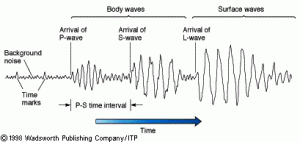
- Early warning systems detect the fast, weak P waves and send alerts before the slower, destructive S and surface waves arrive.
- The warning time is a few seconds to about a minute: enough to stop trains, shut gas valves and take cover.
- Japan: a nationwide system operates.
- Uttarakhand: the Bhookamp Alert app (2021) with IIT Roorkee.
- All India: smartphone-based alerts are issued in partnership with NDMA and NCS.
Structural and Non-Structural Measures
- Earthquake-resistant construction is the most effective safeguard.
- Codes: IS 1893 (design forces), IS 4326 (earthquake-resistant construction) and IS 13920 (ductile detailing of reinforced concrete).
- Measures: retrofitting of schools, hospitals and lifeline buildings, and base isolation, used in the district hospital rebuilt at Bhuj after 2001.
- Cost remains the chief obstacle in India, so structures are prioritised by importance and zone.
- Traditional Himalayan building styles show proven resilience: Kashmir’s timber-laced taq and dhajji dewari houses and the light Assam-type houses of the north-east.
- Non-structural measures:
- public awareness and drills;
- NDMA guidelines on earthquake management;
- NDRF for search and rescue;
- insurance;
- the Sendai Framework (2015–2030), which shifts the emphasis from relief to reducing risk.

Previous Year Questions
2020Demarcating the seismic zones of India, suggest suitable interventions required in the most sensitive seismic zones for sustainable human settlements.2019Discuss the methods of measuring the intensity and magnitude of earthquakes. How are seismic zones demarcated?2014Differentiate between ‘intensity’ and ‘magnitude’ of an earthquake and explain its varying impact in different parts of India.2013Identify the earthquake-prone zones and suggest strategies for their management.





Very informative
dedicated
Thankyou for such high quality content .
Looking forward to read more such amazing explainations.
very helpful thankyou sir for your efforts
TQ u Lotusarise
Kindly add, Earthquake swarm’ is a series of low magnitude earthquakes that occur in a localized region and over a period of time ranging for days, weeks to even months. When seismic energy piles up inside the Earth and is released in small amounts from certain points, such a series of earthquakes can occur.
thanks lotus arise
beautiful
Thank you its very helpful and precise
plz add HP, UK parts of Northern Bihar adjacent to Nepal and WB to zone 4 and zone 5 part