

- Discontinuities are surfaces inside the Earth where seismic-wave velocity changes abruptly, because composition, mineral phase or physical state changes across them.
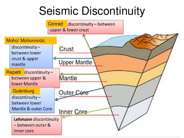
- They separate the shells of the Earth’s interior: upper and lower crust, crust and mantle, upper and lower mantle, mantle and core, outer and inner core.
- They are known almost entirely from seismology: no borehole has crossed even the Moho, so the depth of every boundary comes from how P and S waves speed up, slow down, bend, reflect or vanish.
How Discontinuities Are Detected
- Velocity depends on density and rigidity. In a uniform Earth, waves would travel in straight lines; instead they follow curved paths, concave upward, because velocity generally rises with depth.
- Where properties change gradually, rays bend smoothly; where they change sharply, rays are refracted and reflected, marking a discontinuity.
- Several sets of arrivals from one earthquake show layering.
- Near shallow earthquakes, seismographs record slower direct waves through the upper crust, intermediate waves, and faster waves refracted along the top of the mantle, which overtake the direct ones at larger distances.
- Shadow zones and vanishing waves mark the core.
- S waves cannot cross liquid, so they are absent beyond about 103° from the epicentre; P waves are bent at the core and are not received directly between about 103° and 142°.
| Wave set | P velocity (km/s) | S velocity (km/s) | Medium inferred | Density (g/cm³) |
|---|---|---|---|---|
| Pg–Sg (slowest) | about 5.4–6.1 | about 3.3–3.6 | Granitic upper crust | about 2.7 |
| P*–S* (intermediate) | about 6.5–7.0 | about 3.7–3.9 | Basaltic lower crust | about 3.0 |
| Pn–Sn (fastest) | about 7.8–8.1 | about 4.5 | Peridotite upper mantle | about 3.3 |
- Lower-crust rock was long disputed: Reginald Aldworth Daly and Harold Jeffreys favoured glassy basalt; Alfred Wegener and Arthur Holmes proposed amphibolite. The broad view became basaltic (mafic) rock.
- Keith Edward Bullen (1940s) divided the Earth into seismic regions A to G; the label D″ for the lowermost mantle survives from this scheme.
The Major Discontinuities
| Discontinuity | Average depth | Separates | Named after (year) | Key seismic signature |
|---|---|---|---|---|
| Conrad | 15–20 km (continents only) | Upper and lower crust | Victor Conrad (1923 data) | P rises from about 6.1 to about 6.9 km/s |
| Mohorovičić (Moho) | 5–10 km (oceans), about 35 km (continents) | Crust and mantle | Andrija Mohorovičić (1909) | P jumps to about 8 km/s |
| Repetti | about 660–700 km | Upper and lower mantle | William Charles Repetti | Velocity and density increase |
| Gutenberg | about 2,890 km | Mantle and outer core | Beno Gutenberg (1913) | S vanishes, P drops sharply |
| Lehmann | about 5,150 km | Outer and inner core | Inge Lehmann (1936) | P speeds up; reflections off inner core |
Conrad Discontinuity
- Location: inside the continental crust, at about 15–20 km, between the upper (granitic) and lower (basaltic) crust.
- Discovery: identified by the Austrian seismologist Victor Conrad from records of the 1923 Tauern earthquake in the Austrian Alps, which showed an intermediate P*–S* set.
- Classical meaning: the contact between SIAL (silica–alumina, continents) and SIMA (silica–magnesia), terms from Eduard Suess.
- Current view:
- It is absent beneath oceans and missing in parts of the continents, so it is not a universal layer boundary.
- Since the 1960s the sial–sima idea has been strongly contested; many workers read it as a metamorphic change (amphibolite to granulite facies) or a change in rock fabric, not a sharp chemical contact.
Mohorovičić Discontinuity (Moho)
- Discovery: Andrija Mohorovičić, Croatian seismologist, from the Kupa valley earthquake of 8 October 1909.
- He saw two sets of P and S waves: direct waves through the crust, and faster waves refracted along a deeper, denser layer, which reached distant stations first.
- Signature: P velocity rises from about 6.7–7.2 km/s (basalt-like) to about 7.6–8.6 km/s (peridotite-like); the transition is sharp, not a thick zone.
- Depth:
- 5–10 km below the ocean floor; about 35 km under stable continents, 20–90 km overall.
- Deepest beneath young fold mountains, forming crustal roots that support high relief, as the theories of isostasy require.
- Indian example: receiver-function studies in the Northeast show the Moho at about 35–38 km beneath the Shillong Plateau, 41–42 km under the Brahmaputra valley, about 48 km beneath the Lesser Himalaya and 62–88 km under southern Tibet, the crust thickened by the India–Asia collision.
- Relation to plates: the Moho lies within the lithosphere; only beneath mid-ocean ridges does it coincide with the lithosphere–asthenosphere boundary.
- Seismic vs petrological Moho: since the 1980s, xenoliths and reflection data show the seismic Moho does not always equal the compositional crust–mantle boundary, especially where basaltic sills intrude the base of the crust.
- Unreached: the Kola Superdeep Borehole stopped at about 12 km, well short of the continental Moho.
Repetti Discontinuity and the Mantle Transition Zone
- Classical definition: the boundary between the upper and lower mantle at roughly 700 km, named after William Charles Repetti, a Jesuit seismologist who inferred several internal discontinuities from body-wave travel times.
- Current view: the upper–lower mantle change is split into two global phase boundaries enclosing the mantle transition zone:
- 410 km: olivine turns into denser wadsleyite.
- 660 km: ringwoodite breaks down to bridgmanite and ferropericlase, the true base of the upper mantle.
- Significance:
- The 660 km boundary resists sinking slabs; some pond above it, others pierce into the lower mantle.
- The deepest earthquakes (about 700 km) stop close to it.
- Other upper-mantle boundaries: the low-velocity zone at roughly 100–200 km (asthenosphere), and the Lehmann discontinuity at about 220 km, seen beneath continents but rarely beneath oceans, probably a change in seismic anisotropy. It is distinct from the inner-core boundary.
Gutenberg Discontinuity (Core–Mantle Boundary)
- Discovery:
- Richard Dixon Oldham (1906) first inferred a core from delayed P waves.
- Beno Gutenberg (1913) fixed the boundary at about 2,900 km (now about 2,890 km).
- Harold Jeffreys (1926) showed from tidal rigidity that the outer core is liquid.
- Signature:
- S waves disappear, proving a liquid outer core.
- P velocity falls from about 13.7 to about 8 km/s, creating the P-wave shadow zone.
- Density jumps from about 5.7 to 9.7 g/cm³, from silicate rock to iron–nickel alloy with light elements.
- D″ layer: the lowest ~200 km of the mantle, a thermal and chemical boundary layer.
- Holds ultra-low velocity zones and two continent-sized large low-shear-velocity provinces beneath Africa and the Pacific, widely seen as possible roots of mantle plumes that feed hotspots.
- Uneven surface: the boundary has topography, shaped by mantle convection above and core flow below.
- Heat and magnetism: heat crossing it drives convection in the liquid iron, which generates the geomagnetic field.
- Alternative name: the Wiechert–Gutenberg discontinuity, after Emil Wiechert, whose 1896 shell model first gave the Earth a dense iron core beneath a rocky mantle, and his student Beno Gutenberg.
Lehmann Discontinuity (Inner-Core Boundary)
- Discovery: Inge Lehmann, Danish seismologist, in her 1936 paper P′.
- Faint P waves arriving inside the shadow zone could only be explained by reflection from a solid inner core.
- Also called the Lehmann–Bullen discontinuity.
- Location: about 5,150 km deep; inner-core radius about 1,220 km.
- Signature: P velocity increases; weak S waves travel through the inner core, confirming it is solid despite higher temperature, because pressure raises the melting point.
- Growth: the inner core grows slowly as the outer core freezes at this boundary; released latent heat and light elements power the geodynamo.
- Recent findings:
- An innermost inner core of about 650 km radius, with distinct anisotropy, was reported in Nature Communications (2023) from waves reverberating across the planet.
- Repeating earthquakes near the South Sandwich Islands (1991–2024) show the inner-core surface deforming and its rotation slowing relative to the mantle (Nature Geoscience, February 2025).
Significance of Discontinuities
- Define the layered Earth: crust, mantle and core, and their sub-layers, are drawn from these boundaries, not from direct sampling.
- Explain surface geology:
- Moho depth records crustal thickening and isostatic roots (Himalaya–Tibet).
- Mantle boundaries control slab descent, deep earthquakes and plume rise.
- Explain the magnetic field: the liquid outer core between the Gutenberg and Lehmann boundaries is the seat of the geodynamo.
- Correct older models: the SIAL–SIMA–NIFE scheme and the idea of a fully molten or gaseous core have given way to a seismic, mineral-physics model of phase changes and chemical layers.
Previous Year Questions
2010Bring out the relevance of seismic study in determining the structure of the interior of the earth.2005Write short note: Role of seismic waves in the study of earth’s interior.





Good
Thanks