

- Vulcanicity (vulcanism) is the whole set of processes by which magma and gases originate inside the Earth, rise into the crust and either solidify below the surface or are poured out on it.
- It is driven by the Earth’s internal heat and is one of the main endogenic forces that build relief.
- A volcano is only one part of this process: the vent or fissure through which lava, gases, ash and rock fragments reach the surface, together with the cone built around it.
- Most volcanoes lie along plate boundaries, and the greater part of all volcanism happens unseen on the ocean floor, along mid-ocean ridges.
Vulcanicity: Concept, Materials and Mechanism
Volcano, Vulcanicity and Vulcanism
- P. G. Worcester (1948) defined a volcano as a vent, usually circular, through which heated gases, water, lava and rock fragments are ejected from the interior.
- He used vulcanism broadly, for all movement of heated material from the interior towards the surface.
- S. W. Wooldridge and R. S. Morgan (1959) defined vulcanicity as all processes in which magma rises into the crust or is poured out on its surface, there to solidify as crystalline or semi-crystalline rock.
- Vulcanicity thus has two components:
- Endogenetic (below the surface): origin of magma and gases in the mantle and crust, their ascent, intrusion and cooling as batholiths, laccoliths, sills, dykes and other bodies.
- Exogenetic (at the surface): appearance of lava, ash, fragments, mud and gases as fissure flows, explosive eruptions, hot springs, geysers, fumaroles and mud volcanoes.
Components of a Volcano
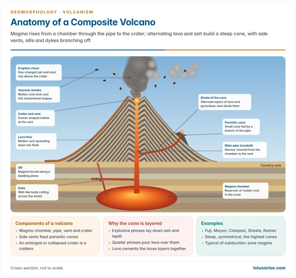
- Magma chamber: a reservoir of molten rock in the crust that feeds eruptions.
- Volcanic pipe (conduit): the narrow channel linking the chamber to the surface.
- Vent (volcanic mouth): the opening at the top of the pipe; side vents feed parasitic cones.
- Crater: the funnel-shaped depression at the vent; a greatly enlarged or collapsed crater is a caldera.
- Volcanic cone: the pile of lava and fragments around the vent; high cones form volcanic mountains.
Volcanic Materials
Gases and Vapour
- Steam makes up 60–90% of the gases of an eruption and up to about 98% at fumaroles.
- It is partly magmatic (from the melt) and partly phreatic (heated groundwater).
- Other gases: carbon dioxide, sulphur dioxide, hydrogen sulphide, hydrogen, carbon monoxide, nitrogen and hydrochloric acid, with volatile metal chlorides.
- Gas content and pressure decide whether an eruption is quiet or explosive.
Magma and Lava
- Magma is molten rock below the surface; it is called lava once it reaches the surface.
- Magma is classed by silica content (acidic vs basic) and by mineral colour (felsic vs mafic).
| Property | Basic (mafic, basaltic) | Intermediate (andesitic) | Acidic (felsic, rhyolitic) |
|---|---|---|---|
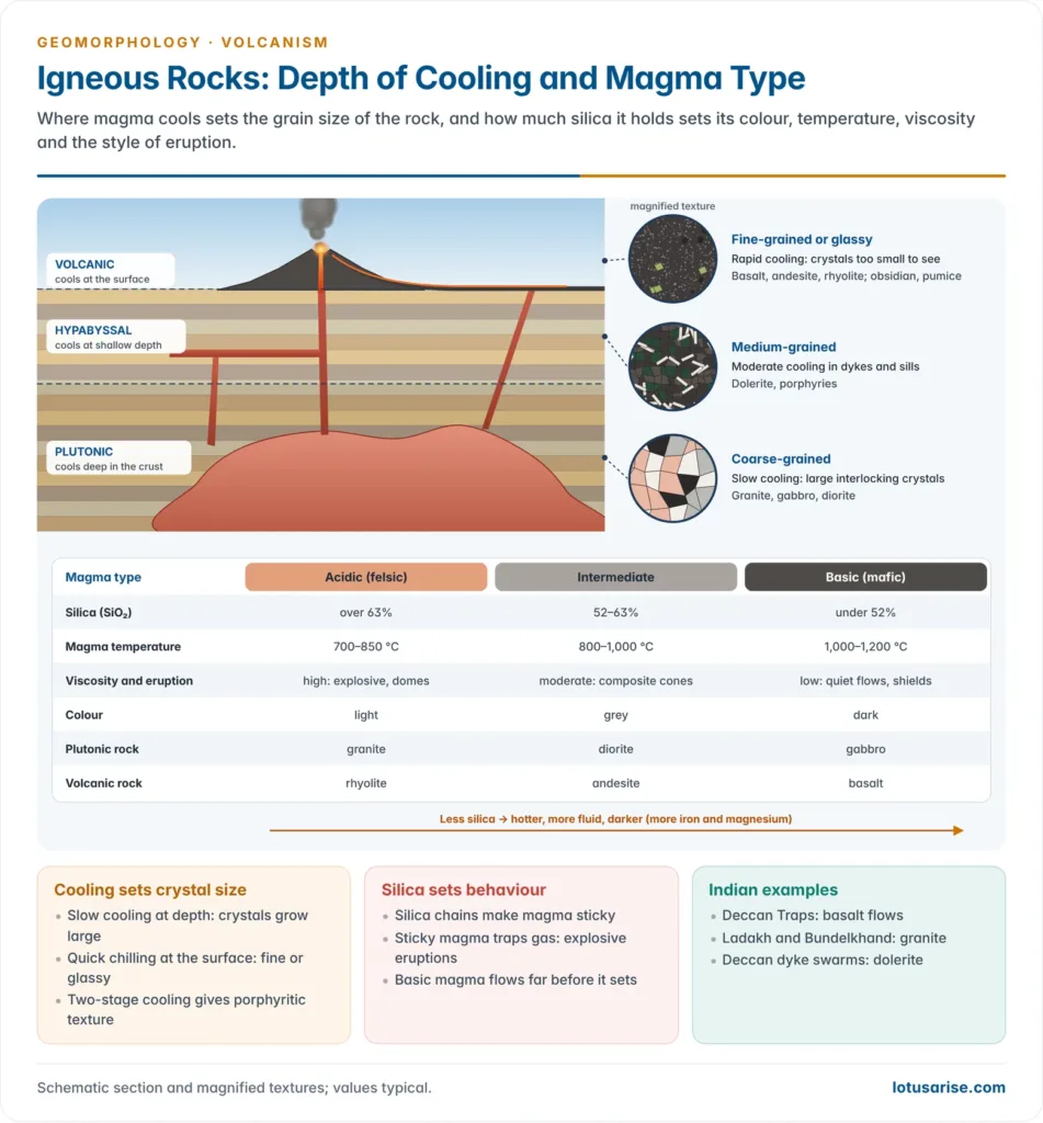
| Silica | Below ~52% | ~52–63% | Above ~63% |
| Temperature | 1,000–1,200 °C (hottest) | 800–1,000 °C | 700–850 °C |
| Viscosity | Low; flows far and fast | Moderate | High; pasty, plugs vents |
| Gas escape | Easy | Moderate | Trapped until explosive |
| Eruption | Quiet, effusive | Explosive, cone-building | Very explosive, domes |
| Landforms | Shields, lava plateaus | Composite cones | Lava domes, calderas |
- Basaltic lava flows are of two kinds (Hawaiian names):
- Pahoehoe: fluid, smooth or ropy surface, spreads in thin sheets.
- Aa (block lava): more viscous and cooler, with a rough, clinkery surface.
- Pillow lava: rounded, sack-like masses formed when lava erupts under water, typical of mid-ocean ridges.
Pyroclastic Materials (Tephra)
- Pyroclasts are fragments blown out by explosive eruptions; collectively called tephra.
- By origin:
- Essential (juvenile): fresh magma of the same eruption.
- Accessory: older volcanic rock of the same volcano.
- Accidental: fragments of the surrounding country rock.
| Size class | Size | Nature |
|---|---|---|
| Volcanic dust | Finest fraction of ash | Carried to the stratosphere |
| Volcanic ash | Below 2 mm | Blankets wide areas; forms tuff |
| Lapilli | 2–64 mm (pea to walnut) | Build cinder cones |
| Bombs and blocks | Above 64 mm | Bombs molten and streamlined; blocks solid and angular |
- The largest bombs can weigh many tonnes and fall kilometres from the vent.
Causes and Mechanism of Vulcanicity
- Heat: temperature rises with depth into the Earth’s interior (roughly 1 °C per 30–35 m in the upper crust), fed largely by radioactive decay.
- Magma generation: the mantle is mostly solid; it melts only where
- pressure falls (decompression melting under rifts and ridges),
- water is added (flux melting above subducting slabs), or
- temperature rises (hot mantle plumes).
- Gases and vapour from magma and from percolating rain and melt-water build pressure and force magma upward through weak zones.
- Eruption style then depends on gas content, magma viscosity and the nature of the crust: explosive central eruptions or quiet fissure flows.
Plate Tectonic Explanation
- Plate tectonics explains why volcanoes cluster: the kind of plate boundary decides the kind of volcanism.
| Setting | Melting process | Magma | Eruption and landforms | Examples |
|---|---|---|---|---|
| Divergent (ridges, rifts) | Decompression of rising mantle | Tholeiitic basalt | Quiet fissure flows, pillow lava, new crust | Mid-Atlantic Ridge, Iceland, East African Rift |
| Ocean–ocean convergence | Flux melting of mantle wedge | Basalt to andesite | Explosive; island arcs | Japan, Aleutians, Andaman arc (Barren Island) |
| Ocean–continent convergence | Flux melting, crustal assimilation | Andesite to rhyolite | Very explosive; stratovolcanoes | Andes, Cascades |
| Intraplate hotspot | Mantle plume | Mostly basalt | Shield chains, flood basalts | Hawaii, Réunion, Deccan Traps |
- Divergent margins:
- Plates move apart, pressure on the upper mantle falls and it partially melts into basalt.
- Magma wells up along fissures, cools into new oceanic crust and is carried away from the ridge by seafloor spreading.
- Because pressure release is slow and gradual, eruptions are quiet.
- Rocks grow older away from the ridge, so volcanic activity dies out with distance from the source.
- Convergent margins:
- The denser plate subducts along the Benioff zone.
- At about 100 km depth, water released from the sinking slab lowers the melting point of the overlying mantle wedge; the wedge, not the slab itself, melts.
- This gas-rich, viscous magma erupts violently, as in the circum-Pacific and Mediterranean belts.
- Hotspots: J. Tuzo Wilson (1963) explained island chains like Hawaii as a plate moving over a fixed hot spot; W. Jason Morgan (1971) linked hotspots to deep mantle plumes.
- The Réunion plume is linked to the Deccan Traps and the Kerguelen plume to the Rajmahal Traps.
Types of Volcanoes and Eruptions
- Volcanoes are classified by (i) the mode of eruption and (ii) the periodicity of eruption.
Classification by Mode of Eruption
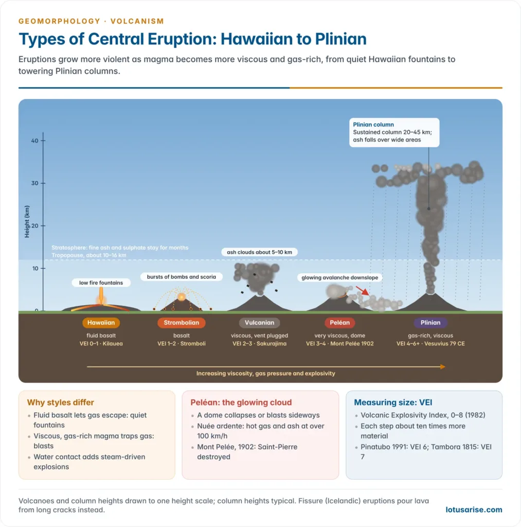
- Central (explosive) type: material bursts out through a pipe and single vent under violent gas pressure, building cones.
- Fissure (quiet) type: lava wells up along long cracks or faults with weak gases and spreads as sheets.
Central Eruption Types
| Type (named after) | Magma | Nature of eruption | Products | VEI | Example |
|---|---|---|---|---|---|
| Hawaiian (Hawaii) | Fluid basalt | Quiet fire fountains | Lava flows, Pele’s hair | 0–1 | Kilauea, Mauna Loa |
| Strombolian (Stromboli) | Basalt | Rhythmic moderate bursts | Bombs, scoria, cinder cones | 1–2 | Stromboli, Paricutin |
| Vulcanian (Vulcano, Aeolian Is.) | Viscous; vent plugged | Short violent blasts | Dark cauliflower ash clouds, blocks | 2–3 | Vulcano, Sakurajima |
| Peléan (Mont Pelée) | Very viscous; dome forms | Dome collapse, lateral blast | Nuée ardente (pyroclastic flow) | 3–4 | Pelée 1902 |
| Vesuvian / Plinian (Vesuvius; Pliny) | Gas-rich, viscous | Sustained column 20–45 km | Pumice, ash fall, flows | 4–6+ | Vesuvius 79 CE, Pinatubo 1991 |
- Hawaiian: low-viscosity lava; glowing blebs drawn out by wind form glassy threads called Pele’s hair.
- Strombolian: near-continuous small explosions keep Stromboli glowing, hence the name “Lighthouse of the Mediterranean”.
- Vulcanian: lava hardens between eruptions and plugs the vent; the next blast shatters the plug into angular fragments.
- Peléan: the most violent classical type; on 8 May 1902 a nuée ardente (“glowing cloud”) from Mont Pelée (Martinique) destroyed Saint-Pierre, killing about 28,000 people, with only two or three survivors.
- Plinian: named after Pliny the Younger, who described the 79 CE eruption of Vesuvius that buried Pompeii; sub-Plinian columns reach roughly 10–20 km.
- Current view: eruptions are graded on the Volcanic Explosivity Index (VEI) of Christopher G. Newhall and Stephen Self (1982), a 0–8 logarithmic scale of erupted volume and column height.
- Krakatoa 1883 and Pinatubo 1991 were VEI 6, Tambora 1815 VEI 7, Hunga Tonga 2022 VEI 5.
Hydrovolcanic (Water-driven) Eruptions
- Phreatic (steam) eruption: magma heats groundwater or surface water to flash steam; the blast throws out old rock and ash, but no fresh magma.
- Short-lived, hard to forecast and deadly near vents: Mount Ontake, Japan (2014) and Whakaari/White Island, New Zealand (2019, 22 deaths).
- Consequences: ballistic blocks, acidic ash, toxic gases, lahars, and often a precursor to magmatic eruption.
- Hydrothermal eruption: a steam blast from a shallow hot-water system without direct magma contact.
- Phreatomagmatic eruption: fresh magma meets water, fragmenting explosively; Surtseyan eruptions build islands (Surtsey, 1963).
- The Hunga Tonga–Hunga Haʻapai eruption (15 January 2022) sent a column about 58 km high, the highest ever recorded, and injected about 146 million tonnes of water into the stratosphere.
Fissure Eruptions
- Lava rises along long fractures and floods the land in successive horizontal sheets, building lava plateaus and plains (flood basalts).
- Flow speed depends on viscosity, volume, slope and temperature.
- Laki fissure (Iceland, 1783): about 14 km³ of basalt from a ~25 km fissure with over 100 vents.
- Fluorine poisoning killed most livestock; the famine that followed killed about one-fifth of Iceland’s people.
- Recent: the Sundhnúkur fissure eruptions on Iceland’s Reykjanes Peninsula (nine eruptions, December 2023–2025) forced the evacuation of Grindavík.
- India: the Deccan Traps are the classic fissure-built flood-basalt plateau.
- Fissure eruptions are also called the Icelandic type, since Iceland, astride the Mid-Atlantic Ridge, is their classic home.
Classification by Periodicity
| Category | Meaning | Examples |
|---|---|---|
| Active | Erupting now or in recorded history, likely to erupt again | Etna, Stromboli, Kilauea, Barren Island (India) |
| Dormant | Long quiet but capable of eruption | Vesuvius (quiet 79 CE–1631, then violent), Kilimanjaro, Narcondam (India) |
| Extinct | No eruption expected; crater often holds a lake | Mount Kenya, Arthur’s Seat (Edinburgh) |
- No volcano can be declared permanently dead: Vesuvius was thought extinct before 1631.
- The Global Volcanism Program (Smithsonian) lists about 1,350–1,400 potentially active volcanoes on land, over 550 with historical eruptions, and some 50–70 erupting each year.
Distribution and Hazards of Volcanoes
World Distribution
- The pattern is zonal: volcanoes follow weak zones of the crust (young fold mountains, rifts, faults and continent–ocean margins) and closely match the belts of earthquakes.
- By plate setting, about 80% of active volcanoes lie on convergent margins, about 15% on divergent margins and the rest in intraplate settings (Hawaii, East Africa).
- Intraplate volcanoes lie away from plate edges, outside the three belts below, and are fed mainly by hotspots:
- Hawaiian–Emperor chain: volcanoes and seamounts about 6,000 km long, ageing north-westward from active Kilauea to seamounts over 80 million years old at the Kuril–Kamchatka Trench.
- Continental flood basalts: Columbia River Plateau (USA, mostly 17–14 million years ago), Paraná (Brazil, about 134 million years ago; with its African twin Etendeka, over 1 million km²) and the Deccan Traps of India.
| Belt | Plate setting | Extent | Examples |
|---|---|---|---|
| Circum-Pacific (“Ring of Fire”) | Ocean–continent and ocean–ocean subduction | Erebus (Antarctica) – Andes – Rockies/Cascades – Alaska, Aleutians – Kamchatka, Japan – Philippines – Indonesia | Cotopaxi, Mt St Helens, Rainier, Fuji, Mayon, Pinatubo, Taal |
| Mid-continental (Alpine–Mediterranean and East African) | Africa–Eurasia collision; continental rifting | Mediterranean, Aegean, Anatolia, Iran, East African Rift | Vesuvius, Etna, Stromboli, Santorini, Kilimanjaro, Nyiragongo |
| Mid-Atlantic (mid-ocean ridge) | Divergence | Iceland to Tristan da Cunha; Azores, Ascension, St Helena | Hekla, Laki, Eldfell (Heimaey, 1973) |
- The circum-Pacific belt holds about three-quarters of the world’s active volcanoes; volcanoes run in chains and island arcs (Aleutians, Japan, Kuril, Philippines).
- Ecuador has a cluster of high cones; Cotopaxi (about 5,900 m) is among the highest active volcanoes, though Ojos del Salado (6,893 m) on the Chile–Argentina border is the highest.
- The mid-continental belt is broken: the Alps and the Himalayas have almost no volcanoes, because the thick, compressed crust of continent–continent collision gives magma no easy path upward.
- The Lesser Antilles (Mont Pelée) are an island arc on a subduction zone, not part of the ridge belt.
- India: the Andaman–Nicobar arc, above the subducting Indian plate, carries Barren Island, India’s only confirmed active volcano, and dormant Narcondam.
- Barren Island erupted in 1787, again in 1991 after a long quiet, and repeatedly in 1994–95, 2005–07 and 2017–2022, with fresh ash emissions in 2025.
Hazards and Benefits
| Hazard | Mechanism | Example |
|---|---|---|
| Lava flows | Bury buildings, farms, roads | Laki 1783; Grindavík 2023–24 |
| Pyroclastic flows (nuée ardente) | Hot gas–ash avalanches at over 100 km/h | Mont Pelée 1902 |
| Ash fall and gases | Crop loss, roof collapse, acid rain, aviation danger | Eyjafjallajökull 2010 air-traffic shutdown in Europe |
| Lahars (volcanic mudflows) | Rain or melted snow mixes with loose ash | Kelud (Java) 1919, about 5,000 deaths; Nevado del Ruiz 1985 |
| Tsunami | Explosion or caldera collapse displaces sea water | Krakatoa 1883, about 36,000 deaths |
| Climate change | Sulphate aerosols reflect sunlight | Tambora 1815 (“year without a summer”, 1816); Pinatubo 1991 |
- Climatic effect: volcanic dust and sulphate aerosols in the stratosphere scatter incoming sunlight but hardly block outgoing terrestrial radiation, so the surface cools.
- Krakatoa (27 August 1883) threw about 20 km³ of material up to tens of kilometres and cooled global climate for several years.
- Pinatubo (June 1991) injected about 17–20 million tonnes of SO₂ and cooled the Northern Hemisphere by about 0.5 °C for a year.
- Tsunamis also follow the earthquakes that accompany eruptions.
- Mass extinctions: great flood-basalt eruptions are linked to extinctions (Siberian Traps with the end-Permian).
- For the dinosaurs’ end about 66 million years ago, current evidence makes the Chicxulub asteroid impact the prime cause, with Deccan volcanism at most a contributing stress.
- Forecasting saves lives: monitoring before Pinatubo allowed about 60,000 people to be evacuated.
- Benefits:
- Fertile soils, such as the black (regur) soils weathered from Deccan basalt.
- Geothermal energy (Iceland, New Zealand).
- Minerals and building stone.
- New land, such as Surtsey and Hawaii.
Volcanic Landforms
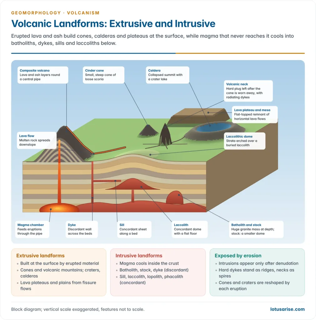
- Landforms of vulcanicity are grouped as extrusive (formed at the surface) and intrusive (formed within the crust).
- Cones and craters are not permanent: each eruption modifies them.
Extrusive Landforms
- Explosive (central) eruptions give elevated forms (cones) and depressed forms (craters, calderas).
- Fissure eruptions give lava plateaus and lava plains.
Volcanic Cones and Volcanic Mountains
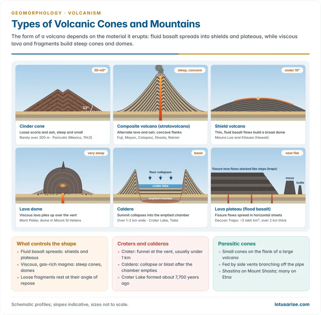
| Cone | Material and build | Slope and size | Example |
|---|---|---|---|
| Cinder (ash) cone | Loose ash, lapilli, scoria round one vent; mostly single eruption | Steep, 30–40°; low, rarely above 300 m | Paricutin (Mexico), Jorullo, Izalco |
| Composite (strato) cone | Alternate layers of lava and pyroclasts; lava cements the layers | Steep, symmetrical; the highest cones | Fuji, Mayon, Cotopaxi, Shasta, Rainier |
| Shield (basic lava) cone | Repeated fluid basalt flows | Gentle, under 10°; very broad | Mauna Loa, Kilauea, Iceland |
| Acid lava cone | Viscous silica-rich lava that sets near the vent | Steep, small | Stromboli-type cones |
| Lava dome | Pasty lava piled over or inside the vent | Steep-sided mound; may explode | Mont Pelée, Mt St Helens dome |
| Parasitic (adventive) cone | Side branch of the main pipe | Small cone on the flank | Shastina on Mt Shasta; Etna’s flank cones |
- Cinder cones are permeable and grow fast.
- Paricutin rose from a cornfield in 1943 and grew over 300 m in about a year.
- Coarse fragments settle near the crater and fine ones farther out.
- Composite cones resist erosion while capped by lava but wear down quickly where pyroclasts form the surface.
- Shield volcanoes are the largest volcanoes by volume, typical of oceanic hotspots, and rarely explode.
- Lava domes are classed as plug domes (filling a vent), endogenous domes (swelling from within) and exogenous domes (built by outpourings on the surface).
- They often grow inside the crater of an earlier eruption.
- Volcanic mountains are large cones built by repeated eruptions.
- Examples: Kilimanjaro (Tanzania), Fuji (Japan), Merapi (Java), Mayon (Philippines), Agung (Bali) and Cotopaxi (Ecuador).
Craters and Calderas
- Crater: the funnel-shaped depression at the vent, commonly a few hundred metres across, with walls sloping at about 25–30° in cinder cones.
- Filled with water, it becomes a crater lake.
- Nested craters are smaller craters inside an older one, formed when later eruptions are weaker; Taal (Philippines) and Vesuvius have them.
- A crater on a parasitic cone is an adventive crater.
- Caldera: a very large, steep-walled basin, usually over 1–2 km wide, formed when the summit collapses into an emptied magma chamber after a huge eruption.
- Origin debate:
- One view saw calderas as the result of subsidence.
- Reginald Aldworth Daly favoured explosive blasting off of the summit, citing pumice and ash found far (over 100 km) from Crater Lake.
- Current view: most large calderas form by collapse following a massive explosive eruption, combining both ideas.
- Crater Lake (Oregon) formed when Mount Mazama collapsed about 7,700 years ago.
- Examples:
- Toba (Sumatra, about 100 × 30 km), formed by the super-eruption of about 74,000 years ago.
- Aira and Aso (Japan), Kutcharo (Hokkaido), Krakatoa, Kilauea, Yellowstone.
- Smaller calderas inside a large one are nested calderas.
- Origin debate:
Lava Plateaus, Plains and Volcanic Necks
- Lava plateaus are built of hundreds of horizontal basalt flows; erosion of these flows gives a step-like (trap) topography.
- Deccan Traps: erupted about 66 million years ago, now covering about 5 lakh km² of Maharashtra, Gujarat, Madhya Pradesh and adjoining states.
- The flows are over 2 km thick near the Western Ghats.
- Other examples: Rajmahal Traps (Jharkhand, about 118 million years), Columbia Plateau (USA), Siberian Traps.
- Deccan Traps: erupted about 66 million years ago, now covering about 5 lakh km² of Maharashtra, Gujarat, Madhya Pradesh and adjoining states.
- Lava plains form where thin fluid flows spread over lowlands.
- Columnar jointing: thick flows crack into hexagonal columns as they cool.
- Examples: Gilbert Hill (Mumbai), St Mary’s Islands (Karnataka), Giant’s Causeway (Northern Ireland).
- Volcanic plug and neck: lava solidified in the pipe of an extinct volcano is exposed when erosion strips the cone.
- A neck of shattered breccia is a diatreme.
- Examples: Shiprock (New Mexico) rises nearly 500 m above the plain; Dhinodhar (Kachchh) and Pavagadh (Gujarat) are eroded plugs and remnants of Deccan-age volcanism, not dormant volcanoes.
Intrusive Landforms
- Where gas pressure is too weak for eruption, magma intrudes into cracks and bedding planes and cools underground.
- Plutonic rocks (e.g. granite) cool slowly at depth and are coarse-grained.
- Hypabyssal rocks (e.g. dolerite) cool at shallow depth.
- Volcanic rocks (e.g. basalt) cool at the surface and are fine-grained.
- These forms appear at the surface only after denudation removes the overlying rocks.
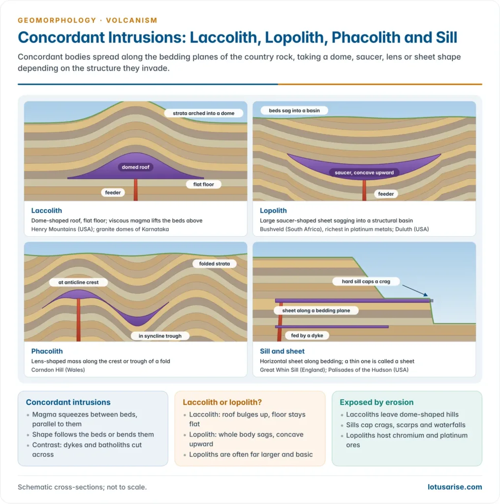
- Concordant bodies lie parallel to the bedding (sill, laccolith, lopolith, phacolith); discordant bodies cut across it (dyke, batholith, stock).
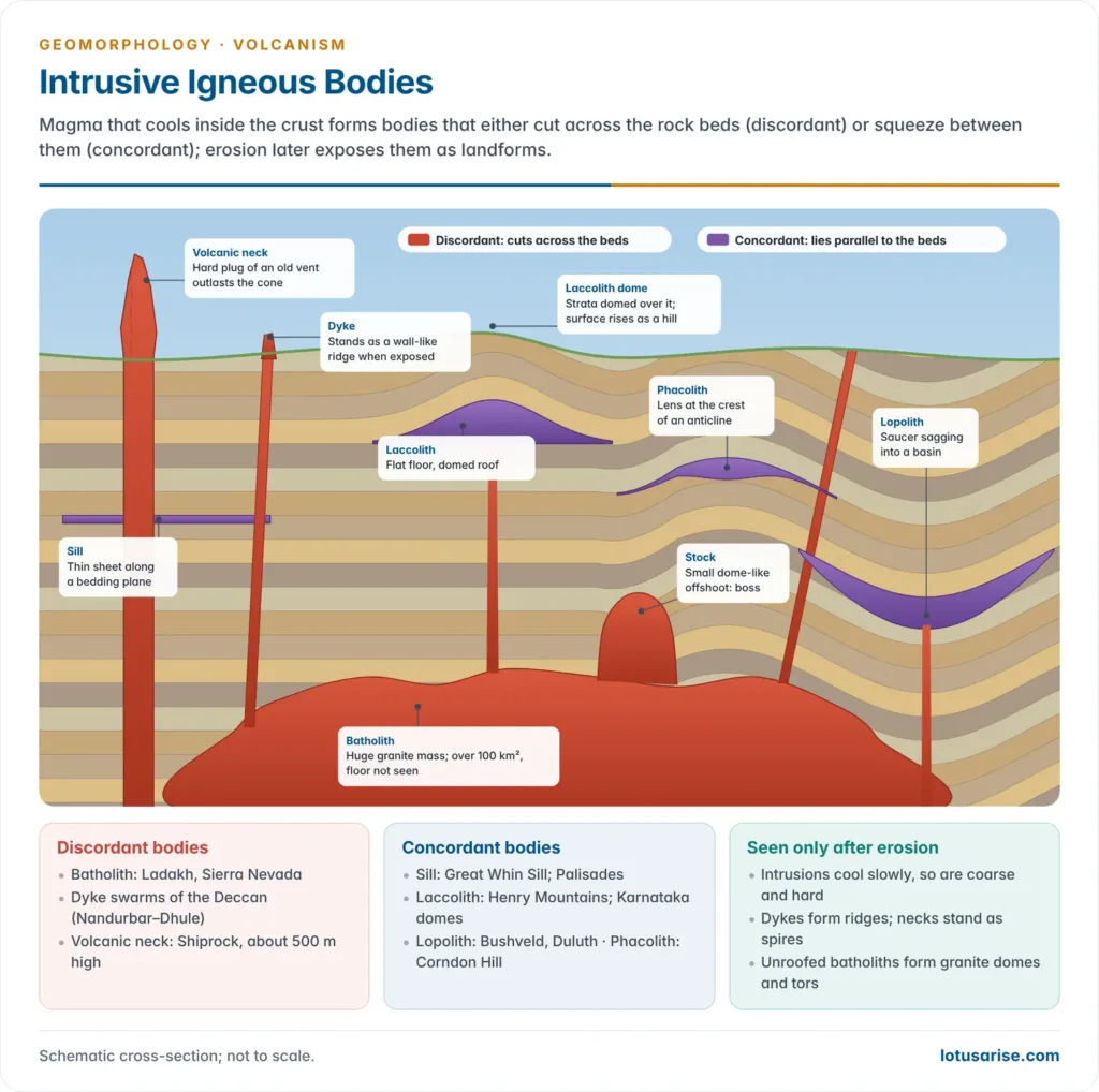
| Form | Shape | Relation to beds | Example |
|---|---|---|---|
| Batholith | Huge, deep-rooted granite mass, over 100 km² | Discordant | Ladakh batholith; Sierra Nevada; Coast Range |
| Stock / boss | Smaller batholith-like body, rounded top | Discordant | Many granite hills |
| Laccolith | Dome-shaped, flat base, fed by a pipe | Concordant | Henry Mountains (Utah); granite domes of the Karnataka plateau |
| Lopolith | Saucer-shaped, concave upward | Concordant | Bushveld (South Africa), Duluth (USA) |
| Phacolith | Lens at the crest of anticlines or trough of synclines | Concordant | Corndon Hill (Shropshire) |
| Sill / sheet | Horizontal sheet along bedding; thin ones are sheets | Concordant | Great Whin Sill (England), Palisades (USA) |
| Dyke | Vertical wall cutting across rocks | Discordant | Deccan dyke swarms (Nandurbar–Dhule) |
- Batholiths:
- The cooled, crystallised magma chambers beneath mountain belts, mainly granite.
- They form the cores of fold mountains and appear as large domes once exposed.
- Laccoliths:
- Magma arched the overlying strata into a dome over a level floor, like a buried volcanic dome.
- G. K. Gilbert (1877) described them in the Henry Mountains.
- The exfoliated granite domes of the Karnataka plateau are commonly cited as exposed laccoliths or batholiths.
- Lopoliths:
- Magma spreading along a weak plane settles into a saucer shape, the floor sagging under its weight.
- They are often layered and rich in ores; Bushveld holds most of the world’s platinum-group metals.
- Phacoliths: wavy, lens-shaped masses in folded country, fed from a magma source beneath.
- Sills:
- Near-horizontal sheets, thick ones called sills and thin ones sheets.
- Exposed, they form benches, ledges and waterfalls.
- Dykes:
- Magma filling vertical cracks cools into wall-like bodies.
- Harder than the host rock, they stand out as ridges; if softer, they form trenches.
- In western Maharashtra they are the commonest intrusive form and served as feeders of the Deccan lava flows.
- Dykes radiating from a centre are radial dykes; circular ones are ring dykes.
Post-volcanic and Pseudo-volcanic Features
Hot Springs and Geysers
- Hot springs discharge heated groundwater continuously.
- Mineral-rich water deposits siliceous sinter and travertine terraces.
- Geysers are intermittent hot springs that explosively spout hot water and steam.
- The name comes from Geysir in Iceland (Icelandic geysa, to gush).
- Arthur Holmes described them as hot springs from which a column of hot water and steam is explosively discharged at intervals.
- Mechanism:
- Water in a narrow, twisting geyser tube (commonly tens of metres long) is heated from below.
- Pressure keeps it superheated until it flashes to steam and empties the tube.
- Water emerges at roughly 75–95 °C.
| Basis | Types | Example |
|---|---|---|
| Vent form | Pool geyser (wide pool, no cone); nozzle (cone) geyser (narrow vent, sinter cone) | Grand Geyser; Old Faithful |
| Periodicity | Regular; variable; long-period; feeble; continuously active (in effect a hot spring) | Old Faithful (regular); Excelsior (continuous) |
- Main regions: Yellowstone (USA, over half the world’s geysers), Iceland (Geysir, Strokkur) and North Island, New Zealand (Rotorua–Taupō).
- India has non-volcanic hot springs fed by deep circulation along faults.
- Examples: Manikaran (Himachal), Puga Valley (Ladakh, a geothermal-energy prospect) and Tattapani (Chhattisgarh).
Fumaroles, Solfataras and Mofettes
- Fumaroles are vents emitting steam and gases after lava emission stops.
- Gases come from cooling magma, and the vents are regarded as the last signs of a dying volcano.
- Steam is about 98% of their gas; the rest is CO₂, HCl, H₂S, nitrogen and ammonia.
- Solfataras are sulphur-rich fumaroles that deposit yellow sulphur (Solfatara near Naples).
- Mofettes emit mainly carbon dioxide at lower temperatures.
- The Valley of Ten Thousand Smokes (Alaska) held thousands of fumaroles along fractures in the ash-flow deposit of the Novarupta–Katmai eruption of 1912.
Mud Volcanoes and Pseudo-volcanic Features
- Pseudo-volcanic features look like volcanic forms but are not built by magma.
- Mud volcanoes: cones of mud and water forced up by gas (mainly methane) from decaying organic matter and tectonic squeezing of sediments.
- They are common in Azerbaijan and along accretionary wedges.
- Baratang (Andaman) mud volcanoes erupted in 2005 after the 2004 earthquake and again on 2 October 2025, raising a mound of 3–4 m.
- Rootless cones (pseudocraters): small craters formed when lava flows over wet ground and steam blasts through it; Mývatn (Iceland) is the classic case.
- Impact craters: circular depressions resembling craters.
- Lonar Lake (Maharashtra) is a meteorite-impact crater in Deccan basalt, not a volcanic one.
- Sand blows (sand volcanoes): liquefied sand ejected during earthquakes, as seen in the Rann of Kachchh in 2001.
Previous Year Questions
2019Describe phreatic eruptions and their consequences.2017Write a note on pseudovolcanic features.1998Discuss the concept of volcanicity and show how the theory of Plate Tectonics explains the mechanism of volcanism and volcanic eruptions.1993Discuss, with examples, the influence of vulcanism and diastrophism on the evolution of landscape.


Your notes are really very helpful pls upload remaining topics soon
Yeah sure, I am doing the same. Keep reading
add qna
Okay!
Hii mahi can these notes be helpful for geography optional preparation…??…
more than enough
No my friend some topic are sufficient but not all u have to read books thoroughly otherwise u can’t get 150 marks in total
Pls sir upload rest of the Geomorphology topic as soon as possible……
Rabindra, For now, I will recommend please read from Geomorphology by Savindra Singh. I have very limited time for writing articles.
I feel that it is more than enough for a NDA aspirant
Thanku so much
Sir please upload history also
Working on it!