

- Sea-floor spreading is the process by which new oceanic crust is created at mid-ocean ridges, moves sideways away from the ridge axis and is finally consumed at deep-sea trenches.
- The hypothesis was put forward by Harry Hammond Hess (circulated 1960, published 1962) and named by Robert S. Dietz (1961); it supplied the mechanism that Alfred Wegener’s continental drift lacked.
- Its proof came from palaeomagnetism, the fossil magnetism locked in rocks, above all the symmetrical magnetic stripes on either side of the ridges.
- Together, palaeomagnetism and sea-floor spreading turned drift into the theory of plate tectonics.
Background: Ocean-Floor Mapping and Mantle Convection
Mapping the ocean floor
- Echo sounding (sonar), used continuously during the Second World War, revealed the true relief of the ocean floor.
- Commanding the transport USS Cape Johnson in the Pacific, Hess kept the echo sounder running and found flat-topped submarine mountains, which he named guyots (1946).
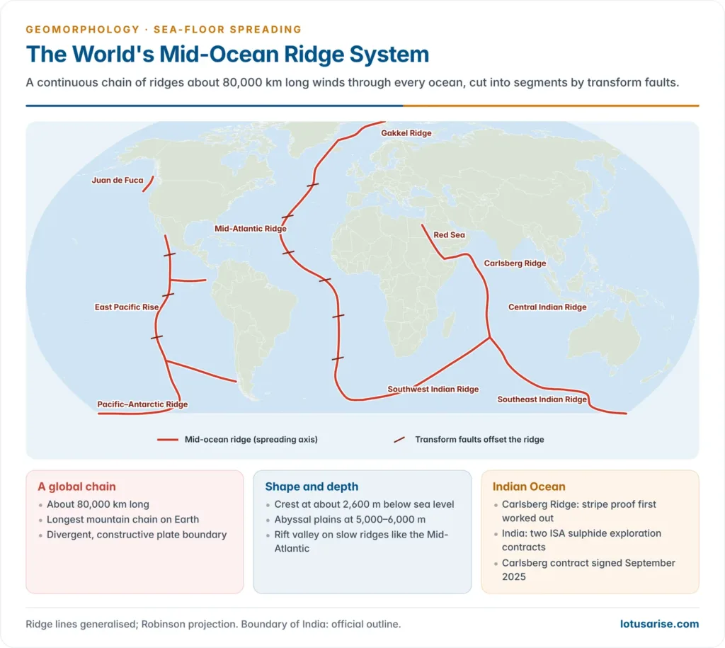
- Surveys of the 1950s traced the mid-ocean ridge as a continuous chain about 80,000 km long, with a central rift valley along slow-spreading segments such as the Mid-Atlantic Ridge.
- Three facts demanded explanation:
- the ocean floor carried far less sediment than billions of years of deposition would leave;
- no ocean-floor rock was older than the Mesozoic;
- ridges showed high heat flow, shallow earthquakes and basaltic volcanism, while trenches showed low heat flow and deep earthquakes.
Convection current theory
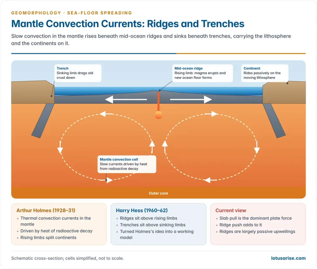
- Arthur Holmes (paper read in 1928, published 1929–31) proposed thermal convection currents in the mantle, driven by heat from the decay of radioactive elements.
- Where rising limbs diverge beneath a continent, it is split and a new ocean opens; where descending limbs converge, crust is dragged down and compressed.
- Holmes offered this as the driving force for continental drift, but it stayed speculative until ocean-floor data arrived.
- Hess placed the mid-ocean ridges above rising limbs and the trenches above descending limbs, turning Holmes’s idea into a working model.
Palaeomagnetism
- Palaeomagnetism is the study of the record of the Earth’s past magnetic field preserved in rocks, sediments and archaeological materials.
- It reveals the direction and polarity of the field when a rock formed, and hence the rock’s former latitude and the position of the magnetic pole at that time.
The geomagnetic field in brief
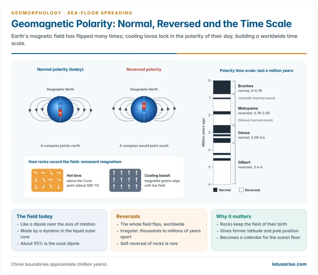
- William Gilbert (1600) first showed that the Earth behaves like a giant magnet.
- The field is roughly that of a dipole at the centre of the Earth, aligned close to the axis of rotation; this geocentric axial dipole accounts for about 95% of the total field.
- A freely suspended needle departs from true north by the magnetic declination and dips from the horizontal by the magnetic inclination (dip): 0° at the magnetic equator, rising to 90° at the magnetic poles.
- The field is not a permanent magnet: it is maintained by a self-exciting dynamo in the liquid, iron-rich outer core, as its slow westward drift shows.
Remanent magnetism
- When lava or magma rich in iron-bearing minerals (magnetite) cools below the Curie point (about 580 °C for magnetite), its magnetic grains align with the field of that moment and the alignment is frozen in.
- This preserved magnetism is called remanent magnetism; the rock’s declination and inclination match the field at the time of formation, and its intensity depends on mineral composition and the field’s strength then.
- Basalt, the iron-rich, low-silica volcanic rock that forms most of the ocean floor, is an excellent recorder.
- Sedimentary rocks are also magnetised, as iron-bearing grains settle parallel to the field, but the signal is weaker and can be destroyed by later chemical change. It is measured in oriented samples with a magnetometer.
Reconstructing past latitudes and poles
- Method: oriented samples of the same age are collected from several sites; their inclination (I) and declination (D) are measured.
- Assuming the averaged field was an axial dipole, the palaeolatitude (λ) of the site follows from tan I = 2 tan λ.
- The latitude gives the distance to the pole; the declination gives its direction. Together they fix the virtual palaeomagnetic pole for that age.
- Sources of error: non-dipole fields, later remagnetisation, tectonic tilting and sampling error, reduced by many samples and statistical averaging.
Apparent polar wandering
- In the 1950s Patrick Blackett and his group (British sandstones about 200 million years old), and Keith Runcorn and Edward Irving, found that pole positions have shifted greatly through time.
- Joined point by point, the poles of successive ages form a polar wandering curve.
- Two readings were possible:
| Interpretation | What moves | Test | Verdict |
|---|---|---|---|
| True polar wandering | Poles move; continents fixed | All continents give one common curve | Rejected |
| Continental drift | Continents move; pole roughly fixed | Each continent gives its own curve | Accepted |
- The curves for Europe and North America run parallel but separate; they merge into one when the Atlantic is closed and the two continents are refitted.
- Refitting all continents into Pangaea gives a single Palaeozoic pole, confirming both the supercontinent and its break-up.
- The old idea of the permanence of continents and ocean basins was thus rejected.
- Indian example: the Deccan Trap lavas (about 66 million years old) carry remanent magnetism placing India well south of the equator, a record of its rapid northward journey.
Reversal of polarity
- About half the rocks sampled are magnetised opposite to the present field; from the 1950s this was found to be worldwide.
- Two explanations were tested:
- Self-reversal: the rock itself acquires reversed magnetism through its mineralogy, as suggested theoretically by Louis Néel; it occurs only in rare minerals.
- Field reversal: the geomagnetic field itself flips, so all rocks formed worldwide at a given time share the same polarity. This is the accepted explanation.
- Reversals are irregular, not periodic; intervals range from tens of thousands to tens of millions of years.
| Chron (epoch) | Polarity | Approximate age (million years) | Shorter events inside it |
|---|---|---|---|
| Brunhes | Normal | 0–0.78 | Laschamp excursion (about 41,000 years ago) |
| Matuyama | Reversed | 0.78–2.58 | Jaramillo, Olduvai (normal) |
| Gauss | Normal | 2.58–3.6 | Kaena, Mammoth (reversed) |
| Gilbert | Reversed | 3.6–6.0 | Cochiti, Nunivak (normal) |
- The long chrons are named after pioneers of geomagnetism; the short events (subchrons) after the places where they were first recorded.
- The first polarity time scale was built in the 1960s by Allan Cox, Richard Doell and Brent Dalrymple from radiometrically dated lavas on land; it became the calendar for reading the ocean floor.
Sea-Floor Spreading Theory
Hess and Dietz: the hypothesis
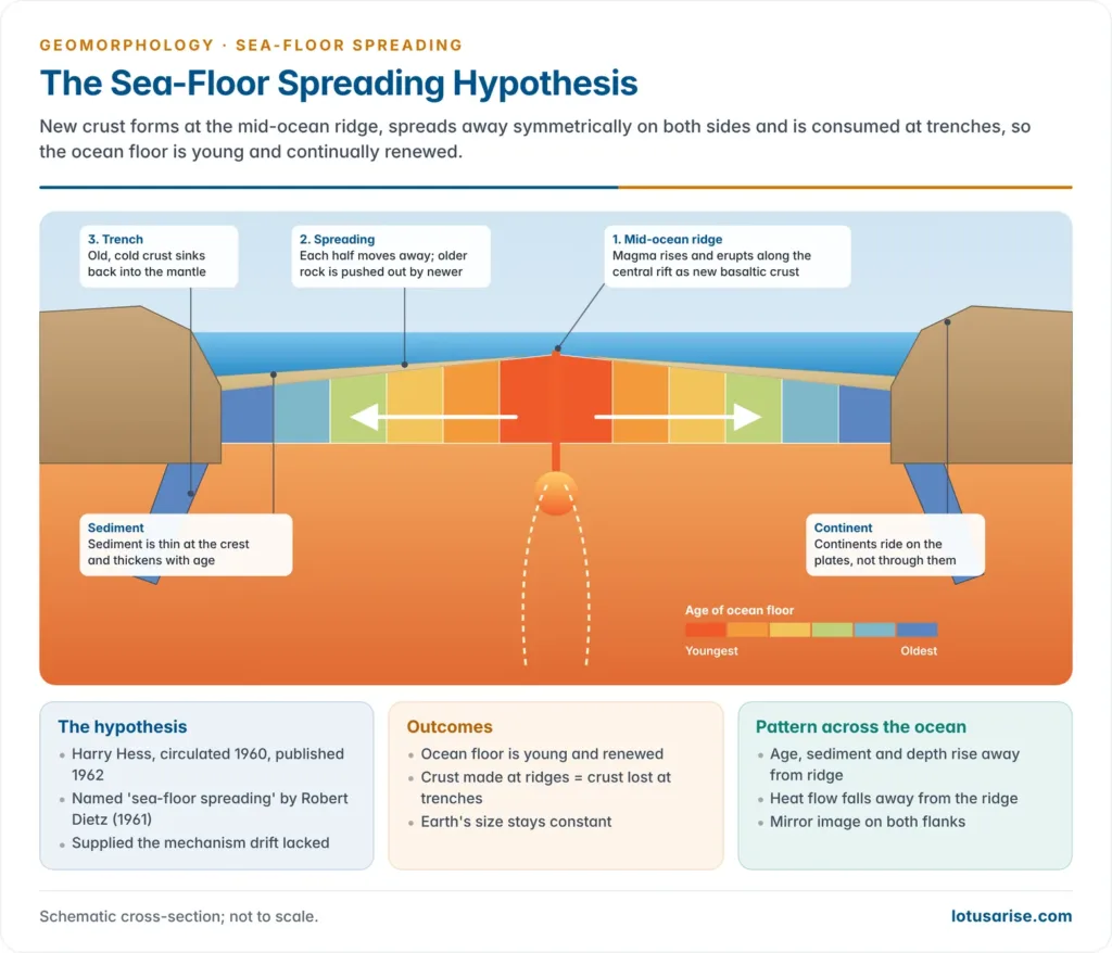
- Harry Hammond Hess of Princeton University circulated the idea in 1960 and published it as History of Ocean Basins (1962), calling it an essay in “geopoetry”. Robert S. Dietz independently coined the term “sea-floor spreading” (1961).
- Assumptions: the mantle convects; oceanic crust is thin, dense and basaltic; continental crust is too light to sink.
- Mechanism:
- Magma rises under the mid-ocean ridge above the upwelling mantle and erupts along the central rift.
- It cools into new basaltic crust, which splits into two halves and moves away from the ridge on both sides, older rock pushed outward by newer.
- At the trenches the old, cold, dense crust sinks back into the mantle (subduction).
- Continents ride passively on the moving crust instead of ploughing through it, as Wegener had supposed.
- Outcomes: the ocean floor is young and continually renewed, and crust created at ridges equals crust destroyed at trenches.
- Mid-ocean ridge: the longest mountain chain on Earth, a divergent (constructive) plate boundary.
- Its crest lies at about 2,600 m depth, above abyssal plains at 5,000–6,000 m, because young, hot lithosphere is buoyant; it cools, thickens and subsides as it moves away.
- It is cut into segments by transform faults, recognised by J. Tuzo Wilson (1965).
Vine–Matthews–Morley hypothesis: the magnetic stripes
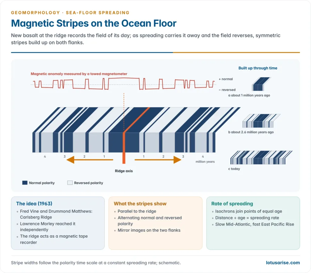
- Ronald Mason and Arthur Raff (Scripps Institution of Oceanography) towed a magnetometer off the western coast of North America from 1955 and published (1961) a map of parallel “zebra” stripes of strong and weak magnetism, then unexplained.
- Frederick Vine and Drummond Matthews (1963) studied the magnetic profile across the Carlsberg Ridge in the Indian Ocean.
- A model assuming uniform magnetisation did not match the observed profile.
- A model of alternate blocks about 20 km wide of normal and reversed magnetisation on both flanks matched closely.
- Explanation: new basalt at the ridge is magnetised in the field of the moment; spreading carries it away while the field keeps reversing, so the ridge becomes a magnetic tape recorder.
- Rock formed in a normal field adds to today’s field and gives a positive anomaly; rock formed in a reversed field gives a negative anomaly.
- The stripes are therefore parallel to the ridge, alternate in polarity and are mirror images on either flank.
- Lawrence Morley reached the same idea independently in 1963, but his paper was rejected; the hypothesis now carries all three names.
- Confirmation: the stripes matched the land-based polarity time scale; Neil Opdyke and colleagues (1966) found the same sequence in deep-sea sediment cores; Walter Pitman and James Heirtzler (1966) published a strikingly symmetrical profile across the Pacific–Antarctic Ridge; and Vine and Wilson (1965) matched it off Vancouver Island.
Rates of spreading
- Lines joining points of equal age on the stripes are isochrons; the distance between isochrons divided by their age difference gives the spreading rate.
- A half rate covers one flank, a full rate both flanks (twice the half rate); mixing the two explains many conflicting figures.
- The Atlantic and Indian Oceans spread slowly and the Pacific fastest; modern classes are:
| Class | Full rate (mm/yr) | Ridge morphology | Examples |
|---|---|---|---|
| Ultraslow | below 20 | Deep rift, scattered volcanism | Gakkel Ridge (Arctic), Southwest Indian Ridge |
| Slow | 20–40 | Rift valley 10–20 km wide, rugged | Mid-Atlantic Ridge (about 25), Carlsberg Ridge (about 26) |
| Intermediate | 40–90 | Transitional | Galápagos, parts of the Central Indian Ridge |
| Fast | above 90 | Smooth axial high, no rift | East Pacific Rise (80–145) |
- The East Pacific Rise exceeded 200 mm/yr in the Miocene, the fastest known.
- Indian example: after leaving Gondwana, the Indian plate moved north at an exceptional 18–20 cm per year in the Late Cretaceous, a speed recorded in the Indian Ocean’s magnetic stripes; it slowed sharply after colliding with Asia.
- Rates are now also measured directly by satellite geodesy (GPS, laser ranging, VLBI), agreeing with the long-term rates from the stripes.
Evidence for sea-floor spreading
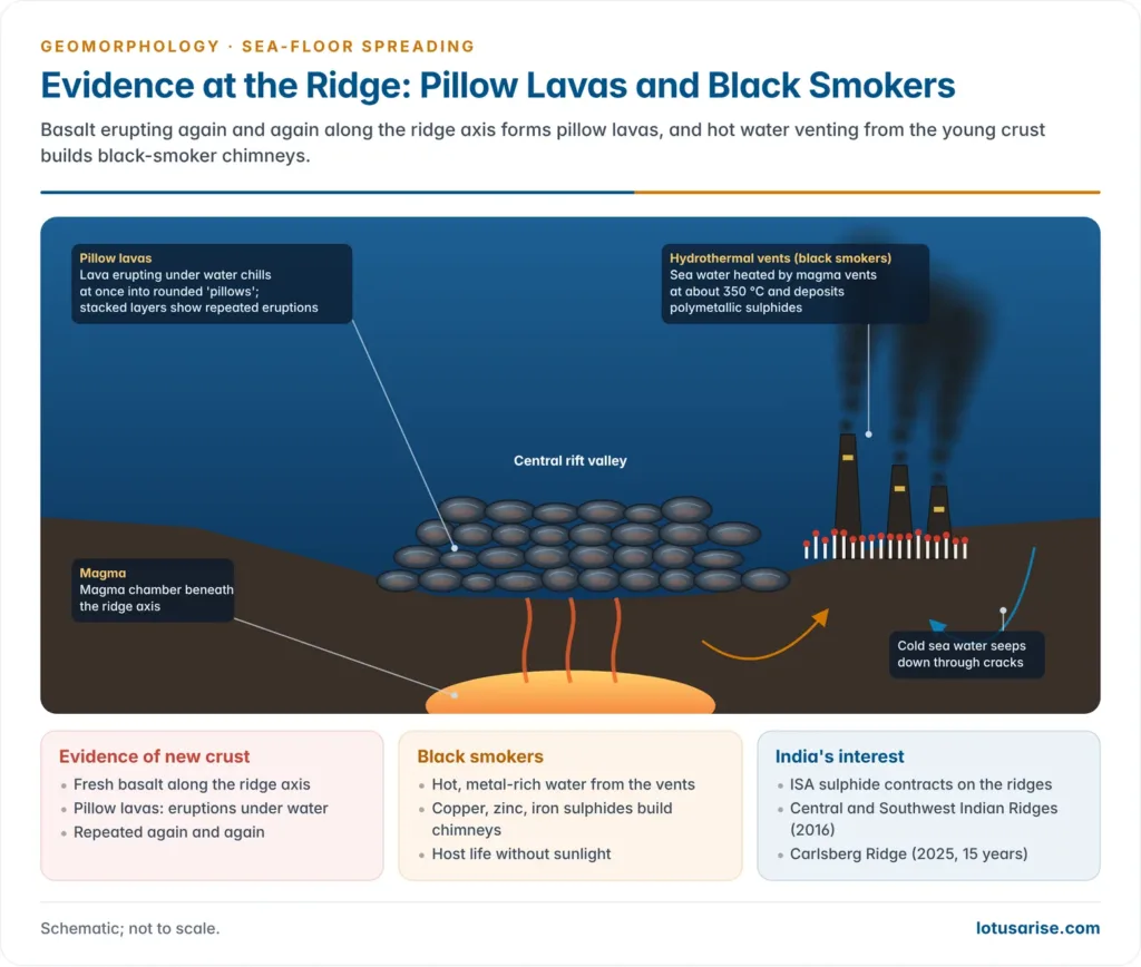
- Molten material: pillow lavas, rounded forms produced when lava erupts under water and chills at once, show that basalt has erupted again and again along the ridge axis.
- The ridges also host hydrothermal vents (black smokers), where sea water heated by the underlying magma deposits polymetallic sulphides.
- Magnetic stripes: alternating, parallel and symmetrical bands of normal and reversed polarity on either side of every ridge.
- Drilling samples: the Deep Sea Drilling Project vessel Glomar Challenger (Leg 3, South Atlantic, 1968–69) showed that the oldest sediment resting on the basalt becomes steadily older away from the ridge, as the stripes predicted, and that South America and Africa are drifting apart.
- The oldest ocean floor is about 180 million years old (Jurassic), in the western Pacific, while continental rocks reach about 4 billion years.
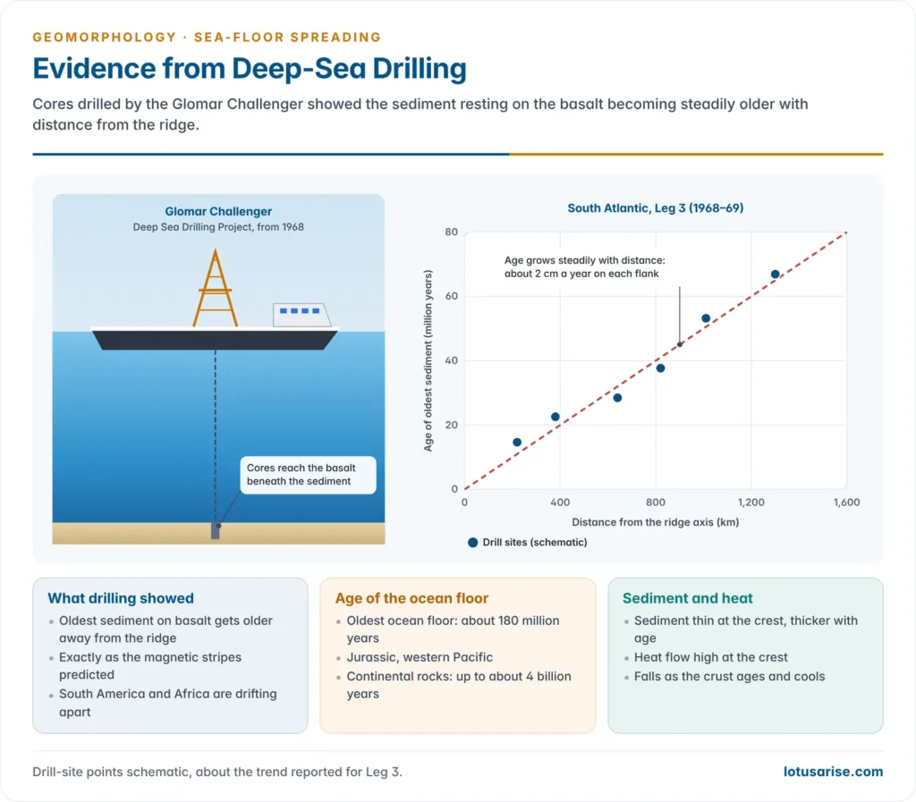
- Sediment and heat flow: sediment is thin or absent at the crest and thickens with age; heat flow is highest at the crest and declines as the crust ages and cools (summarised in the table below).
- Earthquakes: earthquake epicentres form a narrow belt along the ridge crests and transform faults, parallel to the Atlantic coastlines; these are shallow-focus.
- In contrast, earthquakes along subduction zones, especially around the Pacific, deepen landward along the inclined Wadati–Benioff zone to about 700 km, tracing the sinking slab.
- Subduction: old ocean floor sinks beneath a trench back into the mantle, balancing the crust created at the ridges.
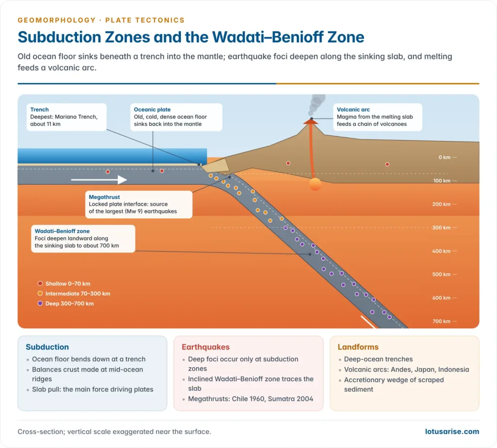
- Deep-ocean trenches: long, narrow, very deep troughs where oceanic crust bends down at subduction zones, such as the Mariana Trench (about 11 km, the deepest point on Earth).
| Observation | At the ridge crest | Away from the ridge |
|---|---|---|
| Age of crust | Youngest (near zero) | Progressively older, up to about 180 million years |
| Sediment | Thin or absent | Thicker |
| Heat flow | High | Low |
| Depth of sea floor | Shallow (about 2.6 km) | Deeper (5–6 km) |
| Magnetic stripes | Present-day normal polarity | Alternating, mirror-image sequence |
Evaluation
Problems solved by the theory
- It explains the young age of the ocean floor, its increase away from the ridges and the thin sediment cover.
- It gives drift a mechanism: continents are carried, not pushed through the ocean floor.
- It keeps the Earth’s size constant, since crust made at ridges is destroyed at trenches, disposing of the expanding-Earth hypothesis.
- It accounts for the distribution of earthquakes, volcanoes, trenches and island arcs, and led directly to plate tectonics after 1967–68.
- It shows that ocean basins open and close: the Atlantic has widened for about 200 million years, the Red Sea is a young ocean now opening, the Pacific is shrinking as its margins are subducted, and the Mediterranean is a remnant of the Tethys.
Criticism and the current view
- Driving force revised: plates are not simply dragged by convection cells like a conveyor belt.
- Analysis of plate motions by Donald Forsyth and Seiya Uyeda (1975) showed that slab pull, the weight of the sinking slab at trenches, is the dominant force, aided by ridge push, the gravitational sliding of young lithosphere off the elevated ridge.
- Mid-ocean ridges are now seen as largely passive upwellings where plates pull apart; ridges can migrate and even be subducted, which fixed convection cells cannot explain.
- Spreading is not always simple: it can be asymmetric, ridges can jump to new positions, and hotspots (such as Iceland and Réunion) add magma independently of the ridge.
- Age limits refined: most ocean floor is younger than about 200 million years, but magnetic data suggest the Herodotus Basin in the eastern Mediterranean may preserve crust about 340 million years old, a remnant of an older ocean (Roi Granot, 2016); this is still debated.
- Polarity record extended: marine anomalies now date the ocean floor back to the Jurassic, including a long interval with no reversals in the Cretaceous (the Cretaceous Normal Superchron).
Indian context
- The Carlsberg Ridge in the north-western Indian Ocean, the northern part of the system that also includes the Central Indian and Southwest Indian Ridges, is where the magnetic-stripe proof was first worked out.
- India holds two International Seabed Authority exploration contracts for polymetallic sulphides formed at these spreading ridges:
- one along the Central and Southwest Indian Ridges (2016);
- one over 10,000 sq km of the Carlsberg Ridge, signed in September 2025 for 15 years, making India the first country to hold two such contracts.
Previous Year Questions
2023“Evidences from palaeomagnetism and sea floor spreading have validated that continents and ocean basins have never been stationary.” Elucidate with suitable diagrams.2013“Offshore acoustic study helped the development of the concept of seafloor spreading.” Explain.2011Write short note on Geomagnetism and Paleomagnetism.2008Write short note on Seafloor spreading theory.





loved
Limitation?👍🏻♥️👌
what is the significance of expanding mid-oceanic ridges in long run or spreading of sea floor?
Sea floor spreading results directly in no. Of volcanoes in verticle convergent boundaries , indirectly summing up CO2 in environment that leads to global warming.
Great
Is palaeomagnetism is important from gs point of view.
not much but important for geography optional