

- Continental drift is the idea that the continents are not fixed in place but have moved horizontally across the globe over geological time, splitting from one another and reassembling.
- The concept is linked above all with Alfred Wegener (1880–1930), a German meteorologist, polar explorer and geophysicist, who first presented it in a lecture at Frankfurt on 6 January 1912.
- Earlier mobilist ideas came from Antonio Snider-Pellegrini (1858) and Frank Bursley Taylor (1908–1910), but Wegener built the first full theory, backed by evidence from many sciences.
- It is one of the theories on the origin of continents and ocean basins, the first-order relief features; its core idea survives inside plate tectonics.
Early Hypotheses on the Origin of Continents and Ocean Basins
Distribution Pattern the Theories Had to Explain
- Early theories were judged by how well they explained the present arrangement of land and water:
- Oceans cover about 71% of the globe; roughly two-thirds of all land lies in the northern hemisphere.
- Continents are triangular, tapering south; oceans taper north.
- The North Pole lies in an ocean, the South Pole on a continent, and almost all land is antipodal to water.
- The Pacific covers about one-third of the globe and is ringed by fold mountains and island arcs.
- Land and water hemispheres: dividing the globe to capture the most land gives a land hemisphere centred near Nantes (France), holding about 80% of all land yet still about 53% water, and a water hemisphere centred near New Zealand’s Bounty Islands, about 89% water.
- The antipodal rule has exceptions: about 15% of land lies opposite land, chiefly Patagonia opposite eastern China and Mongolia, New Zealand opposite Spain and Portugal, and the Malay Archipelago opposite the Amazon basin.
Tetrahedral Hypothesis (William Lowthian Green, 1875)
- William Lowthian Green (1875) explained the land–water pattern through geometry, following the earlier pentagonal network of Léonce Élie de Beaumont.
- Principles:
- A sphere holds the largest volume for its surface area, a tetrahedron the least; a sphere squeezed evenly tends to collapse towards a tetrahedron.
- Mechanism:
- The crust cooled and solidified first while the interior kept contracting; the rigid crust sagged onto it, pushing the earth towards an imperfect tetrahedron.
- Outcome:
- The four flat faces, being lower, held the four oceans: the Arctic on the upper face and the Pacific, Atlantic and Indian oceans on the side faces.
- The edges and corners stood high as continents: the three vertical edges became the Americas, Europe–Africa and Asia; the lower point became Antarctica.
- The northern corners match the Canadian, Baltic and Siberian shields; edges tapering south explain the triangular and antipodal pattern.
- John Walter Gregory (1899) supported it with modifications.
- Criticism:
- A tetrahedron spinning on one apex could not stay balanced, and the fast-rotating earth could not deform into one.
- It assumes permanence of continents and oceans, which drift and plate tectonics have disproved.
Taylor’s Theory of Horizontal Displacement (1908–1910)
- Frank Bursley Taylor presented his idea in 1908 and published it in 1910.
- Aim: to explain the pattern of Tertiary fold mountains (north–south Rockies and Andes, east–west Alpine–Himalayan chain), which the contraction theory could not.
- Assumptions:
- The story begins in the Cretaceous, with two landmasses lying near the North and South Poles.
- Continents were made of sial, which was almost absent from the ocean floor.
- Mechanism:
- The tidal force of the moon drove the landmasses in two directions: towards the equator and towards the west.
- As the northern mass moved away from the pole, tension tore it apart, forming Baffin Bay, the Labrador Sea and Davis Strait; the Arctic Ocean opened between Greenland and Siberia.
- The southern mass split to form the Great Australian Bight and the Ross Sea; the Atlantic and Indian oceans were water-filled gaps between blocks.
- Continents crept forward in lobes along zones of least resistance, piling up mountains and island arcs at their fronts: the Alps, Caucasus and Himalayas from equatorward movement, the Rockies and Andes from westward movement.
- Criticism:
- Mountain building needs only limited horizontal movement, of the order of tens of kilometres; Taylor moved continents thousands of kilometres.
- A lunar tide strong enough to do this would have stopped the earth’s rotation almost at once.
- Arthur Holmes argued that the force for drift and mountain building must come from within the earth, not from outside it.
- Significance: Taylor challenged the permanence of continents and the contraction theory, making an independent start just before Wegener.
| Aspect | Tetrahedral hypothesis | Taylor | Wegener |
|---|---|---|---|
| Year | 1875 | 1908–1910 | 1912–1915 |
| Main aim | Land–water geometry | Tertiary fold mountains | Past climatic changes |
| Starting point | Cooling sphere | Cretaceous, two landmasses | Carboniferous Pangaea |
| Driving force | Contraction on cooling | Tidal force of the moon | Pole-fleeing force, tides of sun and moon |
| Continents | Fixed | Drift equatorward and westward | Drift equatorward and westward |
| Status | Discarded | Discarded | Idea retained in plate tectonics |
Wegener’s Continental Drift Theory
Background and Aim
- Alfred Wegener set out the theory in his lecture of 1912 and in his book Die Entstehung der Kontinente und Ozeane (1915), revised in 1920, 1922 and 1929; the third edition was translated into English in 1924 as The Origin of Continents and Oceans.
- He drew on geology, palaeontology, geophysics and palaeoclimatology, the last with Wladimir Köppen (1924).
- Aim: to explain the major climatic changes of the past, such as glaciation in today’s tropics and coal in today’s polar lands. Two explanations were possible:
- The continents stayed fixed and the climatic belts shifted, or
- The climatic belts stayed fixed and the continents moved.
- Wegener chose the second, rejecting the permanence of continents and ocean basins.
Basic Premise
- Three-layer earth: following Eduard Suess, Wegener divided the interior of the earth into a light outer sial, an intermediate denser sima and a core of nife.
- Sial formed the continents; the ocean floor was the upper sima.
- The sialic continents floated on sima, which he first assumed offered no resistance.
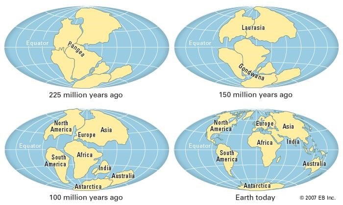
- Pangaea: in the Carboniferous, all land was joined in one supercontinent, Pangaea (“all earth”), dotted with shallow inland seas.
- It was surrounded by a world ocean, Panthalassa (“all water”), the ancestor of the Pacific.
- Its northern part, Laurasia, held North America, Europe and Asia, with the Siberian block of Angaraland at its core.
- Its southern part, Gondwanaland, held South America, Africa, Madagascar, Peninsular India, Australia and Antarctica. The name comes from the Gondwana region of central India, whose rock sequence Henry Benedict Medlicott (1872) named and Eduard Suess extended to the supercontinent.
- The South Pole lay near present-day Durban in southern Africa.
- He did not describe pre-Carboniferous conditions, which were far less certain.
Forces Responsible for the Drift
- Equatorward movement — the “flight from the poles” (Polflucht):
- Caused by the interplay of gravity and buoyancy on floating sialic blocks.
- Because the earth is an oblate ellipsoid with an equatorial bulge, the centre of gravity and the centre of buoyancy of a block do not act in direct opposition; the resultant pushes the block towards the equator.
- The tendency is tied to the earth’s rotation.
- Westward movement:
- Caused by the tidal force of the sun and the moon, dragging the crust westward over the interior; Wegener admitted it was small but argued that over long geological time it could move continents.
Stages in the Break-up of Pangaea
- Stage 1 – Pangaea: a single supercontinent in the Carboniferous, ringed by Panthalassa.
- Stage 2 – Opening of Tethys: gravity and buoyancy split Pangaea into Laurasia in the north and Gondwanaland in the south; the gap between them filled with water as the Tethys Sea.
- Stage 3 – Break-up of Gondwanaland (Cretaceous): Peninsular India, Madagascar, Australia and Antarctica separated; India’s northward drift opened the Indian Ocean.
- Stage 4 – Westward drift of the Americas: North America left Eurasia and South America left Africa, opening the Atlantic Ocean.
- The two Americas drifted at different rates, which Wegener used to explain the S-shape of the Atlantic.
- The Arctic Ocean and North Sea formed as blocks fled the North Pole, and Panthalassa shrank into the Pacific Ocean.
- Stage 5 – Mountain-building stage: drifting and folding continued until the Pliocene, when the present pattern was reached; the Himalayas and Alps rose from the folding of Tethys sediments.
- Current timing: Pangaea had assembled by about 335 million years ago and began to break up about 200 million years ago (Triassic–Jurassic); the Central Atlantic opened in the Jurassic and the South Atlantic in the Early Cretaceous.
- Wegener also mapped the shifting poles and equator:
| Period | North Pole (Wegener) | South Pole (Wegener) | Equator passed through |
|---|---|---|---|
| Silurian | About 14°N, 124°W | North-west of Madagascar | North of Norway |
| Carboniferous | About 16°N, 147°W | Near Durban, southern Africa | London |
| Tertiary | About 51°N, 153°W | About 53°S, south of Africa | Present Alpine belt |
Problems the Theory Claimed to Solve
- Fold mountains: in Wegener’s account of mountain building, the fronts of the westward-moving Americas crumpled against resisting sima into the Rockies and Andes; equatorward movement squeezed Tethys sediments into the Alpine–Himalayan ranges.
- Island arcs and festoons:
- When Asia moved west, its eastern margin lagged behind, leaving the arcs of Sakhalin, the Kuriles, Japan and the Philippines.
- Parts left behind by the Americas formed the arcs of the West Indies and the Southern Antilles between Tierra del Fuego and Antarctica.
- Carboniferous glaciation: with the South Pole near Durban, inside Pangaea, one ice sheet spread over the joined southern lands; later drift scattered them, with their glacial deposits and Glossopteris flora, into lower latitudes.
Evidences in Support of Continental Drift
Jig-Saw Fit of Continents
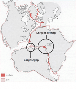
- The opposite coasts of the Atlantic fit together like pieces of a jig-saw, most clearly the bulge of Brazil into the Gulf of Guinea.
- On the other side of Gondwanaland, Africa, Madagascar, India, Antarctica and Australia fit together, with India’s eastern coast against Antarctica.
- The fit is better at the edge of the continental shelf than at the coastline: Edward Bullard (1965) and his co-workers matched the Atlantic margins by computer at the 500-fathom (about 900 m) depth line, with only small overlaps and gaps.
Geological Similarity Across the Atlantic
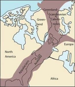
- Mountain systems: the Caledonian and Hercynian fold belts on both sides of the Atlantic match; the Appalachians of eastern North America run to the coast and continue in the old Hercynian ranges of south-west Ireland, Wales and central Europe.
- Rocks and structures: the rock sequences, ages and structures of Brazil and West Africa match closely.
- Alexander du Toit (Our Wandering Continents, 1937) traced these matches in detail.
- Indian example: the Lower Gondwana coal-bearing rocks of the Damodar, Son, Mahanadi and Godavari valleys match the Karoo rocks of southern Africa and Gondwana sequences in Antarctica and Australia.
Permo-Carboniferous Glaciation
- Glacial deposits of late Carboniferous to early Permian age occur in Brazil, the Falkland Islands, southern Africa, Madagascar, Peninsular India, Antarctica and Australia, many of them now in the tropics.
- Tillites and striations show ice flowing in directions that make sense only if these lands were joined around one polar ice sheet.
- Indian example: the Talchir boulder beds (tillites) of Odisha and central India mark the start of Gondwana sedimentation under glacial conditions.
Distribution of Fossils and Plants
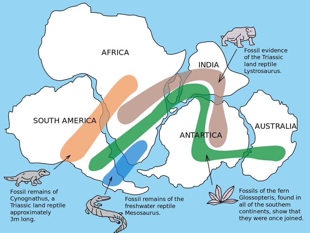
- Plants and animals unable to cross oceans occur on continents now separated by them.
| Fossil | Type and age | Found in | What it shows |
|---|---|---|---|
| Glossopteris | Seed fern, Permian | India, South Africa, South America, Australia, Antarctica, Falklands | One southern landmass with a shared cold-temperate flora |
| Mesosaurus | Small aquatic reptile, Early Permian (about 280 million years ago) | Southern Africa, eastern South America | Could not cross an open ocean |
| Lystrosaurus | Land reptile, Early Triassic | India (Panchet beds, Damodar valley), South Africa, Antarctica | Land link between India, Africa and Antarctica |
| Cynognathus | Land reptile, Triassic | South America, Africa | Land link across the South Atlantic |
- Indian example: Glossopteris is the characteristic plant of the Gondwana coalfields of Jharia and Raniganj.
Palaeoclimatic Evidence
- Coal, formed from lush vegetation in warm, wet climates, occurs today in cold lands such as Antarctica and Svalbard.
- With glacial deposits in tropical India and Africa, this shows the lands once lay in different latitudes.
Geodetic and Biological Evidence
- Geodetic evidence: Wegener cited repeated longitude measurements suggesting that Greenland was moving west.
- His rates were far too high; modern GPS confirms that plates move, but only at a few centimetres a year.
- Biological evidence: migration habits of some animals were read as memories of old land links; the westward rush of Scandinavian lemmings into the sea was the classic example.
Criticism and Current View
Criticism of Wegener’s Theory
- Breaking with the contraction theory and permanent continents, it met strong resistance; critics said Wegener argued as an advocate, passing over unfavourable evidence.
- Inadequate forces:
- Physicists, led by Harold Jeffreys, showed the tidal force is vastly too weak; one strong enough would have stopped the earth’s rotation, and rotation fast enough to drive drift would have flung the atmosphere into space.
- The pole-fleeing force is too small; if it were strong it would have gathered all continents at the equator.
- Self-contradiction on sial and sima:
- Continents were said to float without friction on sima, yet mountains were said to rise from sima’s resistance at their fronts.
- Weak sial cannot plough through stronger sima, and a weaker sima could not crumple sial into mountains.
- In reality it is the whole lithosphere that moves over the weak asthenosphere, not sial through sima.
- Imperfect fit: the coastlines do not match exactly, and Wegener’s reconstructions were loose.
- Gaps in history and direction:
- He left out pre-Carboniferous history, what held Pangaea together until the Mesozoic, why drift began only then, and why it was mainly westward and equatorward.
- Unexplained features: the theory had no account of mid-ocean ridges, trenches or ocean-floor structure, and island arcs were treated only as fragments left behind.
- The theory was largely rejected in the 1920s–30s and lost its main advocate with Wegener’s death on the Greenland ice sheet in November 1930.
Vindication: From Drift to Plate Tectonics
- The central idea, horizontal movement of continents, was proved in the 1950s–60s by new evidence.
- Mechanism: Arthur Holmes proposed convection currents in the mantle, driven by radioactive heat, in a paper read in 1928 and published in 1931, giving drift an internal force.
- Palaeomagnetism: apparent polar-wander paths of the 1950s differed from continent to continent, and matched only when the continents were moved back together.
- Ocean floor: mapping of the mid-ocean ridges, young ocean crust and symmetric magnetic stripes led to sea-floor spreading (Harry Hess, 1962; Frederick Vine and Drummond Matthews, 1963).
- Plate tectonics: John Tuzo Wilson (1965) introduced the term “plate”, and by 1967–68 the full theory had formed, building on drift and on isostasy, the balance of the lithosphere on the mantle.
- Direct measurement: GPS now tracks plate motion year by year.
- Indian example: the Indian Plate broke from Gondwanaland, crossed the Tethys and collided with Asia about 50 million years ago; it still moves roughly 4–5 cm a year towards the north-north-east, raising the Himalayas and driving the region’s earthquakes.
| Aspect | Continental drift (Wegener) | Plate tectonics |
|---|---|---|
| What moves | Sialic continents through sima | Rigid lithospheric plates, continents and ocean floor together |
| Moving over | Sima | Weak asthenosphere |
| Driving force | Pole-fleeing force, tides of sun and moon | Mantle convection, slab pull, ridge push |
| Ocean floor | Passive, permanent | Created at ridges, destroyed at trenches |
| Time span | From Carboniferous Pangaea | Repeated cycles through earth history |
| Mountains and island arcs | Crumpling at front of drifting blocks | Convergent plate boundaries and subduction |
| Evidence base | Fit, fossils, rocks, palaeoclimate | Adds palaeomagnetism, sea-floor age, seismicity, GPS |
Current View
- Wegener was right that continents move and wrong about how: continents do not plough through the ocean floor but ride on plates driven mainly by forces from the mantle, with slab pull the largest.
- His gap on pre-Carboniferous history is now filled by the supercontinent cycle: Pangaea was only the latest of several supercontinents, preceded by Rodinia and Columbia (Nuna).
- The cycle continues: a 2023 climate-modelling study led by Alexander Farnsworth projects a future supercontinent, Pangaea Ultima, in about 250 million years.
- Continental drift thus remains the foundation of modern global tectonics.
Previous Year Questions
2021The concept of Plate Tectonics has been derived from the Isostasy and Continental Drift Theory. Elaborate citing suitable examples.2012Write short notes on Palaeozoic glacial evidence of Continental Drift.2006Critically evaluate the continental drift hypothesis of A. Wegener.1999Bring out the distinctions between the continental drift theory and the plate tectonics theory.1995Discuss the limitations of the theory of Continental Drift and show how the theory of plate Tectonics is an improvement over it.


accurate!
Thanks, Himaan
Nice, super.
Thank you so much🙏
Arise♥️🥇
Whenever i need something concrete topic to read ..i always see lotus arise .thanks a lot .
please increase size of images
Okay
Beautiful 📌
I think wegner has describe the formation of Island arc as ” N.continents move faster than South continents leads to breakage of land peices and Island arc form Ex: Aleutian Island.”
At a greater extent he made it
Accurate
IT GIVEN ANSWER OF EVERY Q RAISING IN MY MIND
Nice explanation, keep it up 👍
It Made concept clear