

- Geomagnetism is the study of the Earth’s magnetic field: its structure, its elements, its origin in the liquid outer core and its changes through time.
- The field varies over hours (solar storms), centuries (secular variation, pole drift) and millions of years (polarity reversals).
- Palaeomagnetism, the field’s record frozen into rocks, made geomagnetism one of the strongest proofs of continental drift, sea-floor spreading and plate tectonics.
- The field deflects the charged particles of the solar wind and cosmic rays, and makes navigation by compass possible.
The Earth’s Magnetic Field
Nature of the Field
- William Gilbert (1600), physician to Queen Elizabeth I, first argued in De Magnete that the Earth itself behaves like a giant magnet.
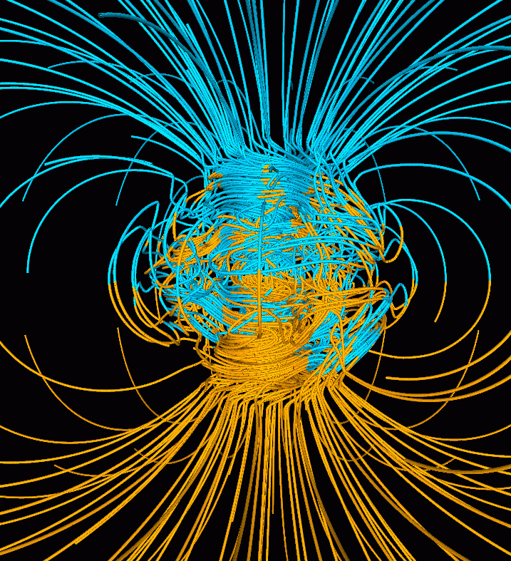
- The field is mainly a geocentric axial dipole, like a bar magnet at the centre roughly aligned with the rotation axis.
- The dipole makes up about 90% of the surface field; the rest is an irregular non-dipole field of regional highs and lows.
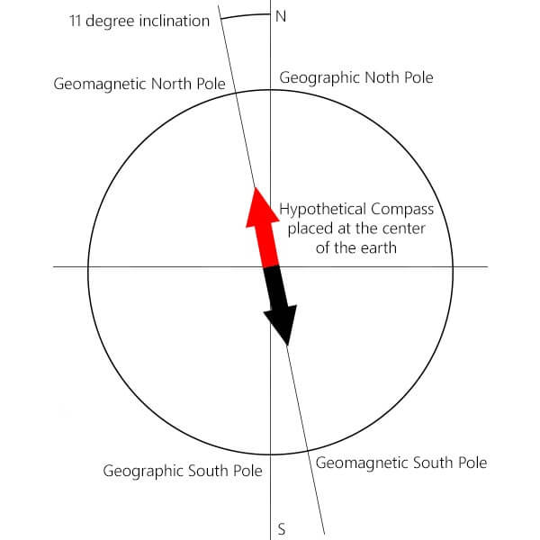
- The dipole axis is now tilted about 9° to the rotation axis.
The Magnetosphere
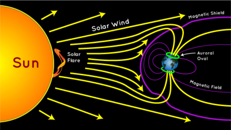
- The magnetosphere is the region of space controlled by the Earth’s field.
- The solar wind compresses its sunward side to about 10 Earth radii (roughly 60,000–65,000 km) and stretches the night side into a long magnetotail.
- It traps particles in the Van Allen belts and funnels them poleward, producing aurorae.
- It deflects charged particles, not radiation: gamma rays, X-rays and ultraviolet are stopped by the atmosphere.
- Geomagnetic storms follow when coronal mass ejections strike it.
- Indian example: during the severe storm of 10–11 May 2024, red aurorae were photographed from Hanle and Merak in Ladakh, a rare sighting near 32° N.
Magnetic Poles and Geomagnetic Poles
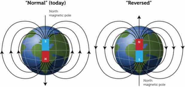
- A compass needle’s north-seeking end is drawn to the North Magnetic Pole; since unlike poles attract, the North Magnetic Pole is magnetically a south pole.
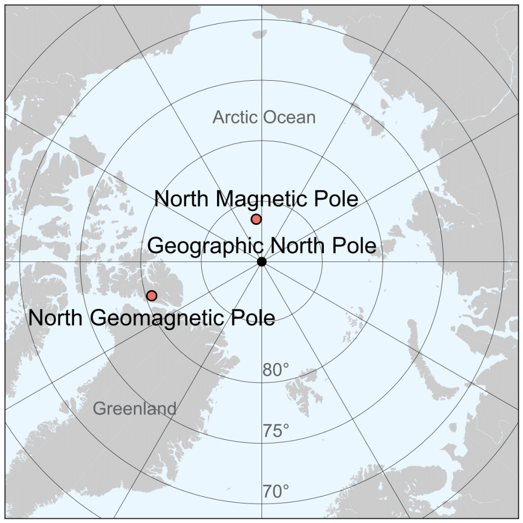
- The poles lie close enough to the geographic poles for a compass to work, but never exactly on them.
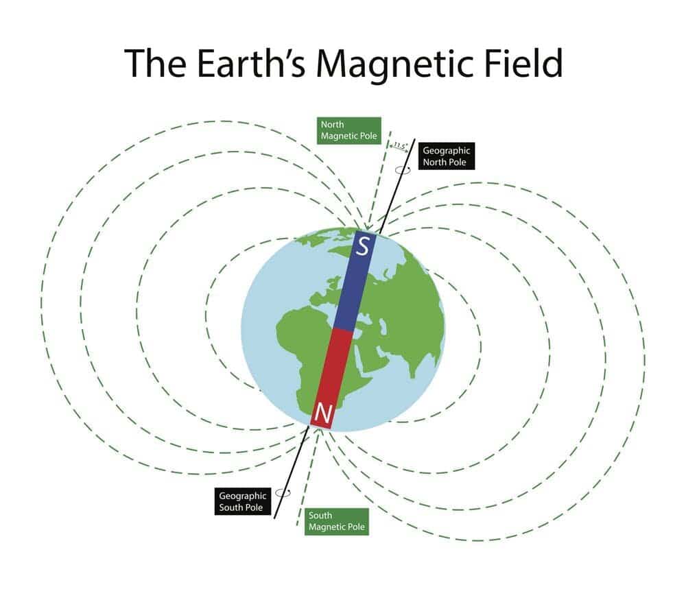
- Geomagnetic (dipole) poles are where the axis of the best-fitting dipole cuts the surface.
- They are antipodal; the northern one lies off north-west Greenland, and the auroral ovals centre on them.
- Magnetic dip poles are where the field is vertical, so a free needle points straight down (north) or straight up (south).
- They are not antipodal, because the real field includes the non-dipole part.
- The South Magnetic Pole lies off the Antarctic coast, outside the Antarctic Circle.
| Feature | Magnetic dip pole | Geomagnetic pole |
|---|---|---|
| Definition | Field vertical (dip 90°) | Best-fit dipole axis meets surface |
| Found by | Field survey, dip needle | Calculation from global field model |
| Antipodal | No | Yes |
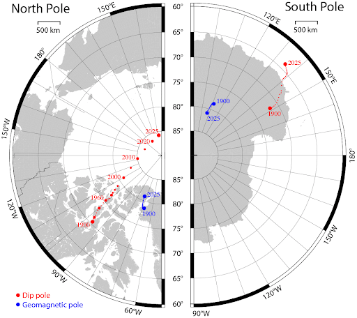
| North pole, 2025 | ~85.8° N, 139.3° E | ~80.9° N, 72.8° W |
| South pole, 2025 | ~63.9° S, 135.1° E | Antipode of the north |
| Movement | Fast, tens of km a year | Slow |
Drift of the North Magnetic Pole
- James Clark Ross first located the north dip pole in 1831 in the Canadian Arctic.
- It drifted slowly for over a century, accelerated to about 55 km a year in the early 2000s while crossing towards Siberia, and has since slowed to about 35 km a year; the South Magnetic Pole moves only about 9 km a year.
- Cause: a tug-of-war between two lobes of strong magnetic flux at the core–mantle boundary; the lobe under Canada is shrinking and the one under Siberia strengthening.
- Consequence: navigation systems, from aircraft to smartphones, rely on the World Magnetic Model; the drift forced an unscheduled update in 2019, and WMM2025 was issued in December 2024.
Elements of the Geomagnetic Field
| Element | What it measures | Instrument | Zero along | Maximum |
|---|---|---|---|---|
| Declination (D) | Angle between magnetic and true north, in the horizontal plane | Compass, declinometer | Agonic line | Near the poles |
| Inclination (I) | Angle between the field and the horizontal plane | Dip circle | Magnetic (dip) equator | 90° at dip poles |
| Total intensity (F) | Strength of the field | Magnetometer | Nowhere | Near the poles |
Magnetic Declination
- Declination is the angle in the horizontal plane between magnetic north and true north.
- It is positive (east) when magnetic north lies east of true north and negative (west) when it lies west.
- Lines of equal declination are isogonic lines; the zero line is the agonic line.
- It changes year by year because the non-dipole field drifts westward at about 0.2° of longitude a year (Edward Bullard, 1950).
- The drift shows the outer core rotating slightly slower than the mantle, placing the field’s source in the core.
- Indian example: declination over India is only a degree or two, so compasses there point close to true north.
Magnetic Inclination (Dip)
- Inclination is the angle between a freely suspended needle and the horizontal plane, as the needle aligns with the curving lines of force.
- It is 0° on the magnetic equator and 90° at the dip poles; lines of equal dip are isoclinic lines.
- For a dipole, tan I = 2 tan λ (λ = magnetic latitude), so a rock’s dip records its latitude.
- The magnetic (dip) equator is the locus of zero dip; it wanders north and south of the geographic equator.
- Indian example: it passes close to India’s southern tip, which is why Thumba near Thiruvananthapuram was chosen in 1963 for India’s rocket station, to study the equatorial electrojet.
Origin of the Geomagnetic Field
Early Explanations and Why They Fail
- Permanent magnet (Gilbert): every material loses permanent magnetism above its Curie point (about 580 °C for magnetite), reached within a few tens of kilometres of the surface; a fixed magnet also cannot explain secular variation or reversals.
- Rock magnetism: crustal magnetisation is real but weak and randomly oriented, producing local anomalies, not a planet-wide dipole.
- Hence the field must be continuously generated and maintained.
Dynamo Theory (Geodynamo)
- Joseph Larmor (1919) proposed a self-exciting dynamo for sunspots; Walter Elsasser (1939; mathematical models 1946–47) and Edward Bullard (1949) applied it to the Earth.
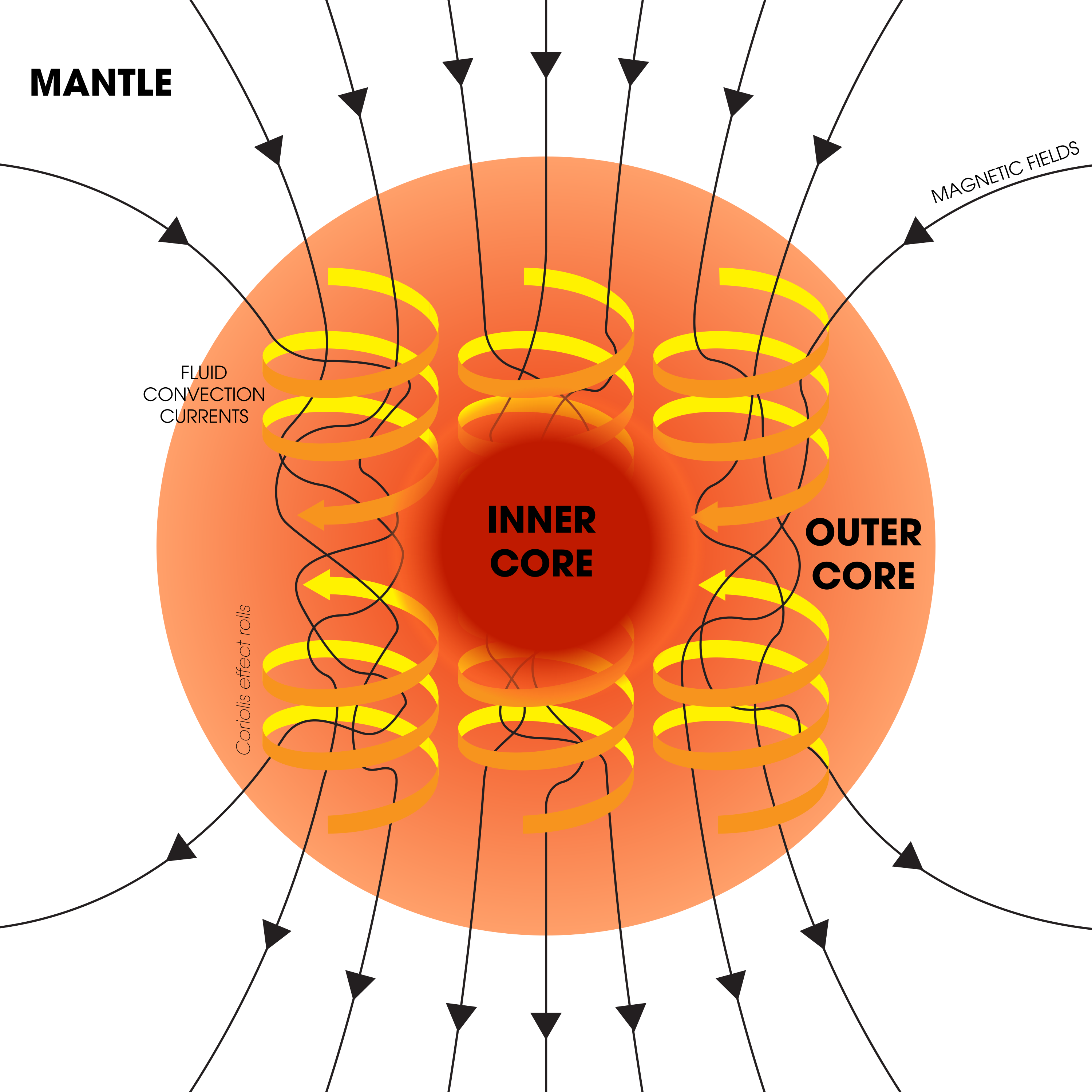
- Assumptions: the outer core (about 2,900–5,150 km deep) is liquid iron–nickel, a good electrical conductor, in convective motion organised by the Earth’s rotation.
- Mechanism:
- Conducting fluid moving through a weak seed field generates electric currents, whose own field reinforces the original: a self-exciting dynamo.
- The Coriolis force twists convection into north–south helical columns, aligning the field with the rotation axis.
- Energy sources:
- Compositional convection: the growing inner core expels light elements (sulphur, oxygen, silicon) that rise through the outer core; now thought the main driver.
- Latent heat of inner-core crystallisation and secular cooling of the core.
- Radioactive heat (e.g. potassium-40): minor and uncertain.
- Evaluation:
- It is the only accepted explanation, accounting for the dipole, secular variation, westward drift and a field over 3.4 billion years old.
- The old objection that it cannot explain reversals has gone: the simulation of Gary Glatzmaier and Paul Roberts (1995) produced a spontaneous reversal with no change in rotation.
- Open questions remain on the inner core’s age and the thermal conductivity of core iron.
Palaeomagnetism
Remanent Magnetism
- Remanent (fossil) magnetism is magnetism acquired by a rock at its formation, parallel to the field of that time.
- Its strength depends on the iron-bearing minerals (magnetite, haematite) and the field intensity; it is measured with magnetometers on oriented samples.
| Type | How acquired | Typical rocks | Reliability |
|---|---|---|---|
| Thermoremanent | Iron minerals cool through the Curie point | Basalt lavas, dykes | High |
| Detrital | Magnetic grains align as they settle | Lake and marine sediments, loess | Moderate |
| Chemical | Minerals grow or alter below the Curie point | Red beds, weathered rocks | Variable; can erase the original |
Reconstructing Past Pole Positions
- Method: sample many oriented rocks of the same age, correct for later tilting, and measure declination and inclination.
- Assume the time-averaged field is a geocentric axial dipole, so the mean magnetic pole matches the geographic pole.
- Inclination gives palaeolatitude (tan I = 2 tan λ) and declination the direction to the pole, fixing a virtual geomagnetic pole.
- Errors from non-dipole components, remagnetisation and orientation are reduced by statistical averaging.
Apparent Polar Wandering
- Poles from Cenozoic lavas of Japan, Italy and France, and Patrick Blackett‘s work on older British sandstones, showed that pole positions changed markedly through time.
- Keith Runcorn and Edward Irving (1950s) plotted these as apparent polar wandering (APW) curves for each continent.
| Interpretation | Assumption | Prediction | Verdict |
|---|---|---|---|
| True polar wandering | Continents fixed, poles moved | One common curve | Rejected |
| Continental drift | Poles fixed, continents moved | Separate curve per continent | Accepted |
- The European and North American curves diverge but coincide when the Atlantic is closed; Palaeozoic poles of all continents fall together in Alfred Wegener’s Pangaea, validating continental drift.
- Indian example: the Deccan Trap basalts (about 66 million years old) record a palaeolatitude near 20° S, showing India’s journey of thousands of kilometres north to Asia.
- On the ocean floor the same record forms symmetric magnetic stripes, the key evidence for sea-floor spreading.
Geomagnetic Reversals
Evidence and Interpretation
- A geomagnetic reversal is a switch in which magnetic north and south exchange places; normal polarity is today’s orientation, reversed polarity the opposite.
- Bernard Brunhes (1906) found reversely magnetised lavas in France; Motonori Matuyama (1929) showed reversed lavas in Japan and Manchuria were of early Quaternary age.
- By the 1950s–60s reversed rocks proved universal, forming roughly half of all samples.
- Two explanations:
- Self-reversal: a mineral process magnetises the rock against the field; Louis Néel showed it possible, but it is rare.
- Field reversal: accepted, because same-age rocks on every continent, lavas and sediments alike, share the same polarity.
Geomagnetic Polarity Time Scale
- Allan Cox, Richard Doell and Brent Dalrymple (1963–64) radiometrically dated lavas of each polarity to build the first polarity time scale.
- Long intervals are chrons (formerly epochs), named after scientists; short ones are subchrons (formerly events), named after the places first studied.
| Chron | Polarity | Age (million years) | Notable subchrons |
|---|---|---|---|
| Brunhes | Normal | 0–0.78 | Excursions only |
| Matuyama | Reversed | 0.78–2.58 | Jaramillo, Olduvai (normal) |
| Gauss | Normal | 2.58–3.6 | Kaena, Mammoth (reversed) |
| Gilbert | Reversed | 3.6–about 6 | Cochiti, Nunivak (normal) |
- The Gauss–Matuyama boundary marks the base of the Quaternary on the geological time scale; such magnetostratigraphy has also dated the Siwalik sediments of the Himalayan foothills.
- Features:
- Irregular, not periodic: about one reversal every 200,000–300,000 years over the last 20 million years, whereas the Sun’s field flips every 11 years.
- Gaps range from tens of thousands of years to the Cretaceous Normal Superchron (about 120–83 million years ago), nearly 40 million years without a reversal.
- The last full reversal, Matuyama–Brunhes, was about 780,000 years ago.
- A transition takes about 1,000–10,000 years: intensity falls, the field turns multipolar, and poles appear at low latitudes before settling reversed.
Geomagnetic Excursions
- An excursion is a brief, large swing of the poles with a deep fall in intensity but no lasting reversal.
- The Laschamp excursion (about 41,000 years ago) cut field strength to roughly 5% of today’s.
Causes of Reversal
- Current view: reversals arise inside the geodynamo from turbulent core flow.
- Reverse-flux patches at the core–mantle boundary grow until they overturn the dipole.
- Changing heat flow across the core–mantle boundary, set by mantle convection, probably controls reversal frequency and superchrons.
- Sunspot (solar linkage) hypothesis: at high sunspot activity the solar wind was supposed to breach a waning geomagnetic shield and re-magnetise the Earth to the Sun’s polarity.
- Unsupported: the Sun’s 11-year flips leave no trace in rocks, and external fields are far too weak to reverse a core dynamo.
- Impact hypothesis (Richard Muller and Donald Morris, 1986): large impacts might disturb core flow; it remains speculative, with no consistent link found.
- Claims that weak-field phases caused mass extinctions are not supported by the fossil record.
The Present Field: Weakening and the South Atlantic Anomaly
- The dipole has weakened by about 9% over two centuries.
- South Atlantic Anomaly: a weak-field zone over South America and the South Atlantic where the inner Van Allen belt dips closest, causing radiation glitches in passing satellites.
- ESA’s Swarm mission shows it has grown by about half the area of continental Europe since 2014, the part south-west of Africa weakening fastest since 2020 as a reverse-flux patch drifts west beneath Africa.
- Evaluation: the field is still stronger than its long-term average, weakening phases have passed without reversals, and no reliable forecast is possible; a reversal would chiefly affect satellites, power grids, navigation and migratory animals.
- Indian monitoring: the Indian Institute of Geomagnetism runs a national observatory network led by Alibag (since 1904, successor to Colaba in Mumbai); the magnetometer on Aditya-L1 (2023) watches the solar wind before it reaches the magnetosphere.
Previous Year Questions
2023“Evidences from palaeomagnetism and sea floor spreading have validated that continents and ocean basins have never been stationary.” Elucidate with suitable diagrams.2011Write short note on Geomagnetism and Paleomagnetism.





one of the best notes for geography optional. It is helping me a lot
Great work and thank you…plz complete the Geo optional ASAP…THANK YOU
Yeah Sure
For the first time getting this complete geography optional materials in a sequenced series that too free of cost. Thank you very much. Really appreciable.
Keep reading and Happy learning.
Thanx a lot lotus arise team
Thanks for providing to the point content for my Geography Optional…..
Thanks Again Lotusarise….❤️❤️❤️
nice content for me
I like your all notes.
I appreciate your hard work.
Thanks you so much
Please mention a book which has geomagnetism in its topics. As far as I know, it is not in Savindra Singh.