

The concept of Plate tectonics has been derived from the isostasy and continental drift theory. Elaborate citing suitable examples. (2021)
- Plate tectonics holds that a rigid lithosphere, broken into seven major and many minor plates, moves over a weak, ductile asthenosphere; its interactions at plate margins explain mountains, trenches, ridges, earthquakes and volcanoes.
- It grew from two older ideas: isostasy — the crust floats in vertical gravitational balance on a denser substratum — and continental drift — continents move horizontally across the globe.
- Neither could stand alone: isostasy explained up-and-down adjustment but not sideways travel, and drift claimed sideways travel without a credible force; mantle convection and sea floor spreading joined them into one theory between 1960 and 1968.
Isostasy: The Floating Lithosphere
- The idea arose from an Indian anomaly: during the Great Trigonometrical Survey under Sir George Everest, the Himalaya deflected plumb lines far less than their visible mass predicted.
- In 1855 two explanations were offered:
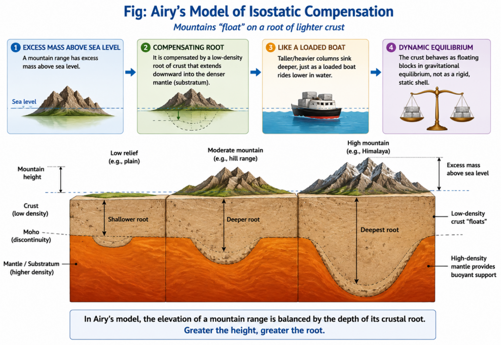
- George Biddell Airy: crust of uniform density but varying thickness — high mountains have deep, light roots projecting into the denser layer below, like a thicker iceberg riding both higher and deeper.
- John Henry Pratt: a uniform depth of compensation with varying density — mountains stand high because their columns are lighter.
- “The fundamental difference between Airy’s and Pratt’s views is that the former postulated a uniform density with varying thickness, and the latter a uniform depth with varying density.” — William Bowie
- Clarence Dutton named the principle isostasy (“equal standing”, 1889).
- What plate tectonics inherited: the same flotation, restated as lithosphere on asthenosphere.
- Continents stand high and ocean floors low because thick, light granitic crust floats higher than thin, dense basaltic crust — the two-level shape of the Earth’s surface.
- Mid-ocean ridges are high because young lithosphere is hot and expanded; as it moves away and cools it contracts and sinks, from about 2.5 km depth at the crest to 5–6 km under old ocean floor — thermal isostasy operating inside a moving plate.
- The Himalaya and Tibet stand on crust about 70 km thick, an Airy-type root.
Continental Drift: The Moving Continents
- Alfred Wegener (1912) assembled the continents into Pangaea, surrounded by Panthalassa, which began to break up about 200 million years ago.
- His evidence still frames the theory:
- Jigsaw fit of South America and Africa (closer still at the continental-shelf edge).
- Matching mountain belts: the Appalachians continue into the Caledonian ranges of Ireland, Scotland and Scandinavia.
- Permo-Carboniferous glaciation recorded in Brazil, southern Africa, peninsular India (the Talchir tillite) and Australia — impossible to explain with today’s continental positions.
- Fossils: Glossopteris flora and the reptile Mesosaurus on now-separated continents.
- Wegener himself argued from isostasy: light continental sial cannot sink into denser sima, so the old “sunken land bridge” explanation of shared fossils was physically impossible — and if continents float, they can also drift.
- Its fatal weakness was mechanism: the pole-fleeing force and tidal drag were far too weak, and rigid sial could not plough through rigid sima.
The Missing Mechanism
- Arthur Holmes (1928–31) proposed mantle convection driven by radioactive heat — a force able to carry floating crust sideways rather than merely up and down.
- Harry Hess (1960–62) gave it testable form as sea floor spreading: new ocean floor forms at ridges above rising mantle and returns to the mantle at trenches.
- Fred Vine and Drummond Matthews (1963), with Lawrence Morley, showed that symmetrical magnetic stripes beside ridges record the spreading.
- Continents are therefore not ploughing through ocean floor; they ride passively on plates — removing the objection that killed drift.
- J. Tuzo Wilson (1965) added transform faults; W. Jason Morgan, Dan McKenzie and Robert Parker, and Xavier Le Pichon (1967–68) completed the rigid-plate model.
The Synthesis, With Examples
- Divergent margins — continents split and oceans open, as drift required: the East African Rift, the young Red Sea, the Mid-Atlantic Ridge.
- Convergent margins — ocean floor is consumed and mountains rise: the Nazca plate beneath the Andes; continent–continent collision in the Himalaya.
- Transform margins — plates slide past each other: the San Andreas Fault between the Pacific and North American plates.
- The Himalaya joins both parents:
- Drift: India, palaeomagnetically traced from the southern hemisphere, still converges on Eurasia at about 4–5 cm a year.
- Isostasy: its thickened crust floats high, but the range is held up partly by the bending strength of the Indian plate, whose flexure created the Ganga foreland basin — a refinement (flexural isostasy) that local Airy compensation could not supply.
- Xu Han, Adam Smith, Matthew Fox and colleagues (2024) attribute roughly 15–50 m of Everest’s height to isostatic rebound after a river capture in the Arun–Kosi system about 89,000 years ago accelerated erosion — isostasy still shaping plate-built mountains today.
How Far “Derived”?
- Plate tectonics kept isostasy’s floating equilibrium and drift’s lateral motion, but rejected the specifics of both: Wegener’s mechanism and continents ploughing through the ocean floor; sial-on-sima and purely local compensation.
- Its decisive proof came from post-1950 marine geophysics — palaeomagnetism, ocean drilling and Benioff zones of earthquakes — which neither parent theory supplied.
- Judgement: plate tectonics is best described as descended from, not derived from, isostasy and continental drift — isostasy gave it the vertical physics and drift the horizontal history, but only mantle convection and sea floor spreading turned the inheritance into a working theory.