

“Evidences from palaeomagnetism and sea floor spreading have validated that continents and ocean basins have never been stationary.” Elucidate with suitable diagrams. (2023)
- Alfred Wegener’s continental drift (1912) argued that the continents once formed Pangaea, but it was rejected for four decades because its driving forces — the pole-fleeing force and tidal drag — were far too weak to move continents.
- Two independent bodies of physical, measurable evidence revived it: palaeomagnetism, which showed that continents have moved, and sea floor spreading, which showed that ocean basins are themselves created, widened and destroyed.
- The statement therefore makes two claims — mobile continents and mobile oceans — and each is tested below before a judgement on the word “never”.
From Circumstantial Fit to Measured Motion
- Wegener’s evidence — the jigsaw fit of the Atlantic margins, the Appalachians continuing into the Caledonian ranges of Ireland, Scotland and Scandinavia, Permo-Carboniferous tillites in Brazil, southern Africa, peninsular India and Australia, and the Glossopteris flora across Gondwana — was resemblance, not proof.
- What the 1950s–60s added was motion recorded inside the rocks themselves, which no static-Earth model could explain away.
Palaeomagnetism: Continents Have Moved
- Thermoremanent magnetisation: as basalt cools through its Curie point (about 580 °C for magnetite), its iron minerals lock in the direction of the Earth’s field — its declination, its polarity and its inclination.
- Because inclination varies with latitude (horizontal at the equator, vertical at the poles), a dated rock records the palaeolatitude at which it formed — a fossil compass reading.
- Apparent polar wander (APW): Keith Runcorn and Edward Irving (1950s) plotted the pole positions recorded by rocks of successive ages.
- Europe and North America yielded two different APW curves for the same period — impossible if only the pole had moved, since the Earth has one magnetic pole at a time.
- Closing the Atlantic on paper made the two curves coincide — the continents, not the pole, had moved apart.
- Indian evidence: the Deccan basalts (about 66 million years old) record a palaeolatitude near 20° S, over the Réunion hotspot; India now lies at 8–37° N.
- Prakash Kumar and colleagues (2007) estimated that India drifted at about 18–20 cm a year in the late Cretaceous — roughly four times today’s speed — before colliding with Asia.
- Limit: a palaeomagnetic pole fixes latitude and rotation but not longitude, so it proves that continents moved without showing where the ocean between them came from — the gap sea floor spreading filled.
Sea Floor Spreading: Ocean Basins Are Not Permanent
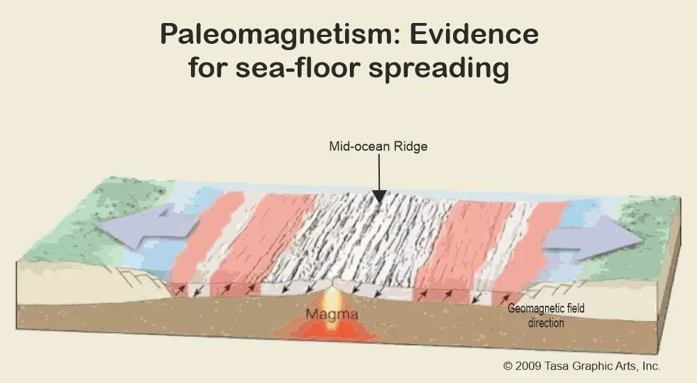
- Harry Hess (manuscript circulated 1960, published 1962) proposed that ocean floor is created at mid-ocean ridges above rising mantle, moves sideways like a conveyor, and is consumed at trenches — so ocean basins are young and continually renewed.
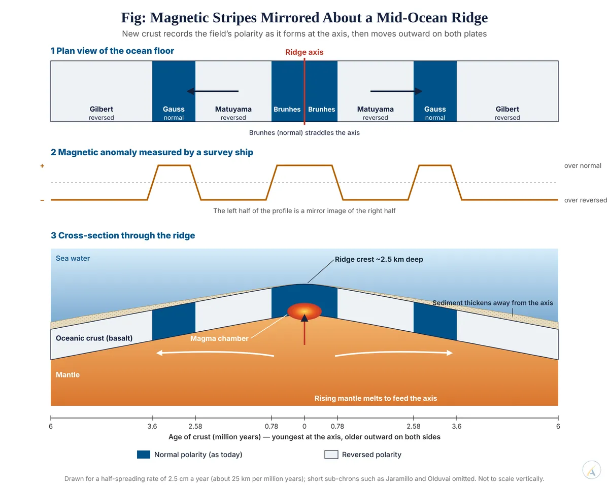
- Geomagnetic reversals made this testable: the field has flipped many times, most recently in the Brunhes–Matuyama reversal about 780,000 years ago.
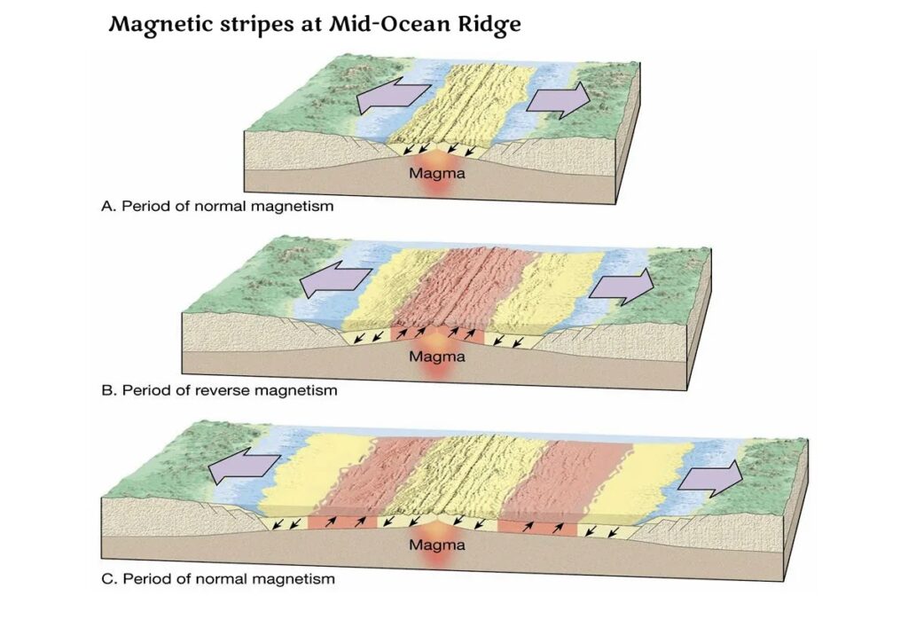
- Vine–Matthews–Morley hypothesis (1963): Fred Vine and Drummond Matthews, and independently Lawrence Morley, reasoned that crust forming at a spreading ridge should record each reversal as a band.
- Surveys confirmed parallel stripes of alternately normal and reversed polarity, mirror-symmetrical about the ridge axis — on the Reykjanes Ridge south of Iceland and across the world ocean.
- The stripe sequence matches the reversal timescale built independently from dated lavas on land, so stripe width divided by age gives the spreading rate: about 2.5 cm a year in the North Atlantic, 8–15 cm a year on the East Pacific Rise.
Confirmation from drilling, faults and hotspots
- Deep Sea Drilling Project cores (1968 onward) showed basement age and sediment thickness increasing with distance from the ridge in both directions, with the youngest crust at the crest.
- No in-place ocean floor is older than about 180–200 million years (western Pacific), while continental rocks reach about 4 billion years — ocean basins are repeatedly recycled; continents are not.
- Roi Granot (2016) identified magnetic stripes beneath the Herodotus Basin of the eastern Mediterranean as oceanic crust about 340 million years old — a rare Tethyan survivor that proves the rule.
- J. Tuzo Wilson’s transform faults (1965) explained ridge offsets; their earthquakes occur only between the offset ridge segments, exactly as spreading predicts.
- The Hawaiian–Emperor chain ages north-westward away from the active hotspot, recording the Pacific plate’s movement; the bend about 47 million years ago marks a change of motion.
Present-Day Measurement
- GPS and other space geodesy now measure plate velocities directly — India moves north-north-east at about 5 cm a year, its continuing convergence with Eurasia still building the Himalaya and driving its earthquakes.
- The rates measured by satellites over decades match those read from magnetic stripes averaged over millions of years — the strongest single proof that spreading is ongoing.
Testing the Word “Never”
- Alec Brenner and Roger Fu (2020) found that 3.18-billion-year-old basalts of the Pilbara craton, Western Australia, drifted at at least 2.5 cm a year — plate-like motion very early.
- John Tarduno and colleagues (2023), using magnetite inclusions in zircons from South Africa’s Barberton belt, found nearly constant palaeolatitudes between about 3.9 and 3.4 billion years ago — consistent with a stagnant-lid Earth without plate motion.
- Judgement: palaeomagnetism and sea floor spreading prove beyond reasonable doubt that continents and ocean basins have been mobile for at least the last 3.2 billion years and are moving now; only for the Earth’s first billion years is “never stationary” an open question rather than a settled fact.
 History Optional Mains Master Kit 2027 Complete Self-Study System — Notes, Mapping & Premium Articles by LotusArise IAS