

Write a note on pseudovolcanic features. (2017)
- Pseudovolcanic features are topographic forms — cones, craters, domes and mounds — that resemble volcanic landforms but are not built by magma rising through a vent from a deep magma chamber.
- The test is genetic, not morphological: a pseudovolcanic form has no magmatic feeder conduit (“root”); its material and energy come from sediment and gas, buried salt, an extraterrestrial impact, or water flashing to steam beneath an already-erupted lava flow.
- The standard classes are mud volcanoes, meteorite impact craters and salt plugs, with rootless cones (pseudocraters) as a volcanic-margin case.
1. Mud Volcanoes — Gas-Driven Sediment Extrusion
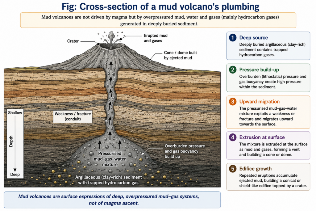
- Form where overpressured, water-rich clay in thick, rapidly buried sediment, charged with methane from petroleum source rocks, rises along faults and is extruded as cold mud, water, gas and rock fragments.
- Pressure comes from sediment loading, tectonic compression and hydrocarbon generation, not from magma.
- Forms: conical or shield-like cones with craters, small steep gryphons, and salses (bubbling mud pools without a cone).
- Distribution: hydrocarbon basins and accretionary prisms at convergent margins — Azerbaijan (nearly half of all the mud volcanoes on Earth, some erupting with ignited gas flames), the Makran coast, Myanmar and the Andaman arc.
- Zalzala Koh, a mud-volcano island, rose off Gwadar (Pakistan) after the 24 September 2013 earthquake and had sunk back by the end of 2016.
- India — Baratang (Middle Andaman): India’s only active mud volcano erupted on 2 October 2025, its first major eruption since 2005; the Geological Survey of India found mud at only about 30 °C, weakly alkaline, with an oily sheen and fragments of Palaeogene (Oligocene-age, per the GSI) marine sandstone and shale — direct proof of a sedimentary, non-magmatic source.
- Live debate — Lusi (East Java, 2006): Mark Tingay, Maxwell Rudolph, Michael Manga and colleagues (2015) used well gas data to argue that the Banjar Panji-1 gas well, not the Yogyakarta earthquake two days earlier, triggered the eruption; Stephen A. Miller and Adriano Mazzini (2018) defend a natural trigger linked to a hydrothermal system fed by the nearby Arjuno–Welirang volcanic complex. The case shows that some “pseudo” systems still draw heat from magma at depth.
2. Meteorite Impact Craters
- Hypervelocity impact excavates a circular bowl with a raised rim and ejecta blanket, easily mistaken for a volcanic explosion crater or caldera; older literature even called such structures “cryptovolcanic”.
- Lonar crater (Buldhana, Maharashtra): about 1.83 km across and 150 m deep, cut into Deccan basalt; long regarded as a volcanic crater lake, its impact origin was confirmed by shock-metamorphic evidence — maskelynite (shocked plagioclase glass) and shatter cones.
- Its age is disputed: thermoluminescence gave about 52,000 years, while argon–argon dating by Fred Jourdan and colleagues (2011) gave 570,000 ± 47,000 years, a figure later questioned for possible inherited argon.
- Meteor (Barringer) Crater, Arizona, is the classic world example.
3. Salt Plugs (Salt Domes and Diapirs)
- Buried evaporite (rock salt), lighter and weaker than its cover, flows upward under pressure as a diapir, arching and piercing overlying strata into dome- or cone-shaped hills.
- Where salt reaches the surface in an arid climate, as in the Zagros Mountains of Iran, it forms domes with collapse pits and slow salt glaciers that mimic lava domes and flows.
4. Rootless Cones (Pseudocraters)
- Form when hot lava flows over a wet surface — a marsh, lake margin or pond; trapped water flashes to steam and explodes up through the flow, piling tephra into small crater-topped cones.
- They are made of genuine lava but have no conduit to a magma chamber; the mechanism is phreatic in style, with the heat source at the surface rather than at depth.
- Examples: Skútustaðagígar at Lake Mývatn and Rauðhólar near Reykjavík, Iceland; similar cone fields on Mars are read as evidence of past lava–ground-ice interaction.
Significance
- Resource indicator: mud volcanoes and salt domes signal hydrocarbon traps at depth.
- Hazard: sudden mud eruptions, methane fires and land loss (Lusi displaced tens of thousands).
- Classification lesson: identical form can arise from four unrelated processes, so landform genesis must be read from material and structure, not shape.
- Judgement: pseudovolcanic features are best treated as a genetic, not a shape-based, category; recent evidence — Baratang’s cold sedimentary mud, Lonar’s shocked minerals, the Lusi trigger dispute — shows that the decisive question is always what supplies the energy and the material.