

- A tsunami is a series of ocean waves of very long wavelength and long period set off when an impulsive disturbance suddenly displaces a large volume of water, most often a submarine earthquake.
- The word is Japanese: “tsu” (harbour) + “nami” (wave), the “harbour wave” that wrecked ports though fishermen at sea noticed nothing.
- It is not a tidal wave: tides play no part in its origin.
- A tsunami is a wave train, not a single wave; the waves arrive minutes to an hour apart, and the first is often not the largest.
- It is the main marine hazard of earthquakes and belongs chiefly to the convergent plate margins.
Causes of Tsunami
Conditions for a Tsunami
- An energy source must transfer energy to the water column, usually an undersea earthquake.
- The sea floor, or the water surface, must be displaced vertically.
- Hence tsunamis rise mainly near oceanic trenches, where one plate is thrust beneath another along a megathrust fault.
- Earthquakes on mid-oceanic ridges and transform faults (the Mid-Atlantic Ridge) are moderate, and their plates slide horizontally, so they rarely raise a tsunami.
- Tsunamigenic earthquakes are those capable of generating a tsunami:
- magnitude generally above about 7;
- shallow focus (within roughly the top 100 km, most within 50 km);
- dip-slip (thrust or normal) motion that lifts or drops the sea floor.
Types of Causes
Earthquakes
- Earthquakes cause roughly 80–90% of historical tsunamis.
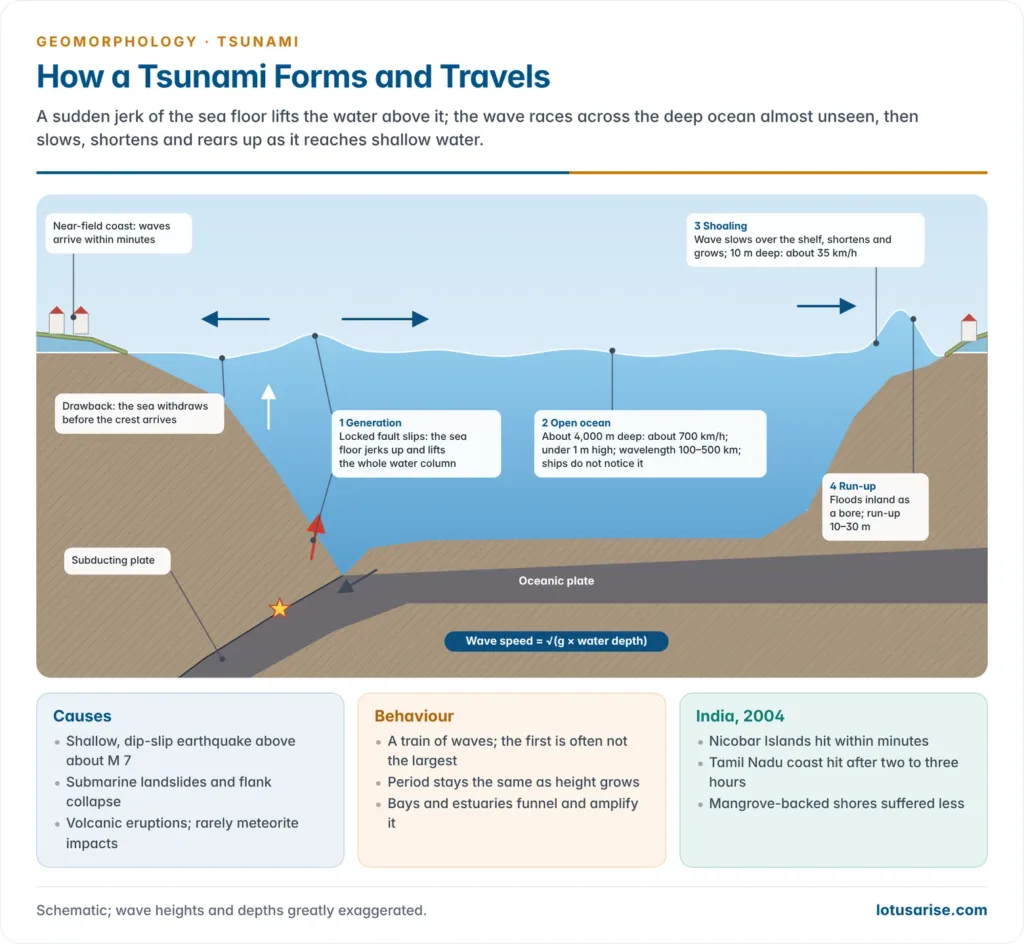
- At a subduction zone the overriding plate is dragged down and locked; when the fault slips it springs back upward, lifting the sea floor and the whole water column above it.
Landslides
- Submarine slumps and coastal landslides on continental slopes, trench walls or steep shores push water aside abruptly.
- They can produce very high local waves from even moderate earthquakes, as in Papua New Guinea (1998), where an M 7.0 shock set off a submarine slump and waves of about 15 m.
- A rockfall into Lituya Bay, Alaska (1958) sent water up to a record 524 m on the opposite slope.
Volcanic Eruptions
- Explosive volcanic eruptions, caldera collapse, pyroclastic flows entering the sea and volcano flank collapse all displace water.
- Krakatau (Indonesia, 1883) produced waves of 30–40 m that killed about 36,000 people on Java and Sumatra.
Other Sources
- Meteorite or asteroid impacts in the ocean: the Chicxulub impact at the end of the Cretaceous raised a global mega-tsunami.
- Meteotsunamis: sudden jumps in atmospheric pressure (squall lines, or the pressure wave of a giant eruption) force sea-level oscillations.
- Underwater nuclear or chemical explosions can raise small local waves.
| Cause | Mechanism | Warning time | Example |
|---|---|---|---|
| Earthquake | Vertical fault slip lifts or drops sea floor | Minutes to hours | Sumatra 2004, Tohoku 2011 |
| Landslide | Mass slides into or under water | Very little; local | Papua New Guinea 1998, Lituya Bay 1958 |
| Volcanic | Explosion, caldera or flank collapse | Very little; often no seismic trigger | Krakatau 1883, Anak Krakatau 2018 |
| Atmospheric | Pressure wave forces sea level | Travels at speed of sound | Tonga 2022 far-field waves |
| Impact | Bolide strikes the ocean | None | Chicxulub, end-Cretaceous |
Generation and Characteristics
Process of Generation
- Initial displacement: the sea floor rises or falls by metres over a zone that may be hundreds of kilometres long, and the sea surface above mirrors it.
- Collapse and spread: gravity pulls the bulge down and waves radiate outward in both directions from the rupture.
- Where the coast faces the downthrown side, the trough arrives first and the sea withdraws before the crest; this “drawback” is a natural warning sign.
Propagation in the Open Ocean
- A tsunami is a shallow-water wave even in the deep ocean, because its wavelength (100–500 km) is far greater than the ocean depth.
- Its speed therefore depends only on depth: speed = √(g × d), where g is gravitational acceleration and d the water depth.
- Over a 4,000–5,000 m deep ocean this gives 700–800 km/h, a jet-liner’s speed, and up to about 950 km/h over the deepest basins.
- In deep water the wave height is usually under 1 m and the slope is gentle, so it passes unnoticed beneath ships.
- The whole water column moves, and energy loss is small, so a tsunami can cross an entire ocean: the 1960 Chile tsunami killed people in Japan about 22 hours later.
Shoaling and Run-up at the Coast
- As the wave enters shallow water, speed falls with depth, the wavelength shortens and the rear of the wave catches up with the front.
- The period stays constant and the energy flux is nearly conserved, so the energy is squeezed into less water and wave height rises sharply; this is the shoaling effect.
- A wave of well under a metre at sea can rise to 10–30 m, and locally more, at the shore.
- The wave rarely breaks like a surf wave; it arrives as a fast-rising flood or turbulent bore that runs far inland.
- Run-up is the maximum height above sea level reached on land; inundation distance is how far inland it reaches.
- Coastal shape amplifies the wave: funnel-shaped bays, harbours and estuaries concentrate the energy, while offshore reefs, wide shelves and mangroves dampen it.
| Feature | Deep ocean | Near the coast |
|---|---|---|
| Speed | 700–950 km/h | 30–50 km/h |
| Wavelength | 100–500 km | a few km to tens of km |
| Height | under 1 m | 10–30 m or more |
| Period | 5 min to over 1 h | unchanged |
| Noticeable? | Not to ships | Destructive flood |
Tsunami, Wind Waves and Storm Surge
| Feature | Wind wave | Tsunami | Storm surge |
|---|---|---|---|
| Cause | Wind on sea surface | Sudden water displacement | Cyclone winds and low pressure |
| Period | Seconds | Minutes to an hour | Hours |
| Wavelength | Metres to ~200 m | 100–500 km | Hundreds of km |
| Water moved | Surface layer | Entire water column | Coastal water piled up |
| Forecast lead | Days | Minutes to hours | Days |
Distribution
- The Pacific Ocean records most tsunamis because it is girdled by subduction zones, the Ring of Fire, and averages about two damaging tsunamis a year.
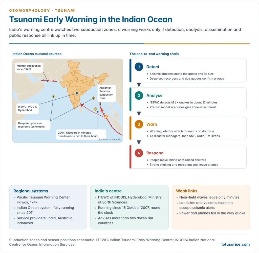
- The Indian Ocean has two main source zones:
- the Andaman–Sumatra (Sunda) subduction zone in the east;
- the Makran subduction zone off Pakistan and Iran in the north-west.
- The Mediterranean and Caribbean carry lower but real risk, as shown by the Lisbon earthquake (1755), whose tsunami struck Portugal and Morocco and crossed the Atlantic to the West Indies; tens of thousands died.
Major Tsunamis
| Year | Event | Source | Key facts |
|---|---|---|---|
| 1883 | Krakatau, Indonesia | Volcanic eruption | 30–40 m waves; ~36,000 deaths |
| 1946 | Aleutian Islands | M 8.6 earthquake | Devastated Hilo, Hawaii; led to PTWC |
| 1960 | Chile | M 9.5, largest recorded | Pacific-wide; deaths in Chile, Hawaii, Japan |
| 1964 | Alaska | M 9.2 | Coastal uplift up to ~11 m; Pacific-wide waves |
| 2004 | Sumatra–Andaman | M 9.1–9.3 | ~228,000 deaths in 14 countries |
| 2011 | Tohoku, Japan | M 9.0–9.1 | Run-up ~40 m; Fukushima accident |
| 2018 | Palu, Sulawesi | M 7.5 strike-slip + landslides | ~4,340 deaths |
| 2018 | Anak Krakatau | Volcano flank collapse | ~430 deaths; no warning |
| 2022 | Hunga Tonga–Hunga Ha’apai | Eruption and pressure wave | Global meteotsunami; deaths as far as Peru |
| 2025 | Kamchatka, Russia | M 8.8 | Pacific-wide alerts; small waves, mass evacuations |
- Other Pacific-wide tsunamis of the mid-20th century:
- Kamchatka (4 November 1952, Mw 9.0): waves of 15–18 m destroyed Severo-Kurilsk in the Kuril Islands and damaged Hawaii.
- Andreanof Islands, Aleutians (9 March 1957, Mw 8.6): run-up reached about 16 m on Kauai, Hawaii.
Indian Ocean Tsunami, 2004
- On 26 December 2004 an earthquake of M 9.1–9.3 ruptured about 1,300 km of the boundary where the Indian Plate subducts beneath the Burma Plate, off north-west Sumatra.
- The sea floor rose by several metres, displacing tens of cubic kilometres of water.
- Run-up reached about 51 m in Aceh; about 228,000 people died in 14 countries, the worst tsunami disaster on record.
- India: more than 10,000 deaths, mostly on the Tamil Nadu coast (Nagapattinam) and in the Andaman and Nicobar Islands.
- The waves reached the Nicobars within minutes and the Tamil Nadu coast in about two to three hours, yet no Indian Ocean warning system existed to use that time.
- Coasts backed by mangroves (Pichavaram, Muthupet) suffered less damage than open shores.
Tohoku Tsunami, Japan, 2011
- On 11 March 2011 an M 9.0–9.1 megathrust earthquake struck about 130 km east of Sendai, where the Pacific Plate subducts beneath north-east Honshu.
- Waves overtopped sea walls built for smaller events; run-up reached about 40 m near Miyako, and nearly 20,000 people were dead or missing.
- The quake shifted parts of Honshu about 2.4 m east, moved the Earth’s figure axis by 10–25 cm and shortened the day by about 1.8 microseconds.
- Flooding disabled the Fukushima Daiichi nuclear plant, forcing a 20 km evacuation zone; it showed that engineered defences alone cannot stop an extreme tsunami.
Non-seismic Tsunamis: Recent Lessons
- Palu (2018): a strike-slip fault, normally a weak tsunami source, triggered coastal and submarine landslides inside a narrow bay; waves arrived within minutes.
- Anak Krakatau (2018): a flank collapse of the volcano at night sent waves onto Java and Sumatra with no earthquake to trigger a warning.
- Hunga Tonga (2022): the eruption’s atmospheric pressure wave drove sea-level changes across all oceans, arriving faster than an ordinary tsunami.
Tsunami Risk to India
- East coast and islands: the Andaman–Sumatra subduction zone threatens the Andaman and Nicobar Islands (near-field, minutes) and the east coast (far-field, hours).
- Major coastal projects in the Nicobars lie within the 2004 rupture zone.
- West coast: the Makran subduction zone produced the 1945 Makran tsunami (M 8.1, 28 November 1945), which killed hundreds to a few thousand people on the Makran coast and reached Gujarat and Mumbai.
- Kutch (16 June 1819): the Rann of Kutch earthquake raised the Allah Bund ridge (about 80 km long, ~6 m high), sank the Sindri area, and a local tsunami flooded part of the Great Rann.
Tsunami Warning and Mitigation
Tsunami Early Warning System
- Earthquakes cannot be predicted, so the time of a tsunami cannot be foretold; historical records and numerical models only show where tsunamis are likely.
- The most effective defence is an end-to-end early warning system, built on two equally important parts:
- Detection: a network of sensors to identify and confirm a tsunami;
- Dissemination: a communication chain that reaches the coast in time for evacuation.
- Sensors:
- Seismic networks locate the earthquake and estimate its size within minutes.
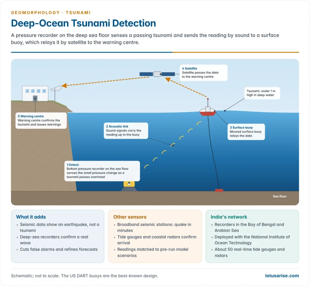
- Bottom pressure recorders (tsunami buoys) on the deep sea floor sense a passing tsunami as a tiny change in water pressure; the DART (Deep-ocean Assessment and Reporting of Tsunamis) buoys of the US are the best-known design.
- Tide gauges and coastal radars confirm arrival and size at the shore.
- Warnings reach the public by SMS, radio, television, sirens and loudspeakers.
Global and Regional Systems
- Pacific Tsunami Warning Center (PTWC): set up by the US in 1949 at Ewa Beach, Hawaii, after the 1946 Aleutian tsunami.
- After the 1960 Chile tsunami, UNESCO’s Intergovernmental Oceanographic Commission (IOC) built an international Pacific Tsunami Warning System in the 1960s.
- Indian Ocean Tsunami Warning and Mitigation System (IOTWMS): coordinated by the IOC after 2004 and fully operational since 2011.
- It runs on three Regional Tsunami Service Providers (RTSPs): India, Australia and Indonesia.
- Similar IOC systems cover the Caribbean and the North-east Atlantic and Mediterranean.
India’s Tsunami Early Warning Centre
- The Indian Tsunami Early Warning Centre (ITEWC) at the Indian National Centre for Ocean Information Services (INCOIS), Hyderabad, under the Ministry of Earth Sciences, was inaugurated on 15 October 2007.
- Network:
- a national network of broadband seismic stations, plus real-time data from global networks;
- bottom pressure recorders in the Bay of Bengal and Arabian Sea, deployed with the National Institute of Ocean Technology;
- about 50 real-time tide gauges and coastal radar stations.
- Performance: it detects Indian Ocean earthquakes above M 6 in under about 12 minutes and uses a database of pre-run model scenarios to issue location-specific warnings, alerts and watches by coastal zone.
- It serves as an RTSP for the whole Indian Ocean, advising more than two dozen rim countries, and works round the clock.
Mitigation and Preparedness
- Hazard mapping: inundation and coastal multi-hazard vulnerability maps guide land use and evacuation routes.
- Land-use control: Coastal Regulation Zone setbacks, and siting of critical facilities away from low shores.
- Bioshields: mangroves, casuarina belts and coastal dunes absorb wave energy, as the 2004 experience on the Tamil Nadu coast showed.
- Engineering: sea walls, breakwaters, tsunami-resistant buildings and vertical evacuation shelters on raised ground.
- Community preparedness:
- Tsunami Ready is an IOC recognition for communities that meet set indicators of mapping, signage, plans, drills and awareness.
- Venkatraipur (Ganjam) and Noliasahi (Jagatsinghpur), Odisha, were the first Indian Ocean communities recognised, in 2020, and 24 more Odisha villages followed in 2024; the programme is being extended to the Andaman and Nicobar Islands.
- Regional IOWave exercises test the whole warning chain, and 5 November is World Tsunami Awareness Day (UN General Assembly, 2015).
- Institutions: the National Disaster Management Authority issued national guidelines on the management of tsunamis in 2010.
Evaluation of Warning Systems
- Near-field tsunamis leave little time: the Andaman and Nicobar Islands or the Makran coast may get only minutes, so self-evacuation on strong shaking or sea withdrawal matters more than any bulletin.
- Non-seismic tsunamis from landslides and volcanoes escape seismic-based warnings, as Palu, Anak Krakatau and Tonga showed.
- Warning centres are adding volcano-tsunami procedures, and INCOIS is mapping submarine landslide zones.
- The “last mile” is the weakest link: sirens, power and phone networks often fail in the very quake that sets off the tsunami.
- Over-warning and complacency are risks, since many alerts end in small waves; yet the 2025 Kamchatka event, where millions were warned within minutes and about 1.9 million people evacuated in Japan, shows how far systems have come since 2004.
Previous Year Questions
- No direct PYQ has been asked on this sub-topic yet.


sir your notes are really good and in a well organised way .pls upload remaining topics
Sure
Too amazing notes. Thanks a lot 😍
thnq so much