In this article, You will read Himalayas Formation & Relief and Structure of Himalayas – for UPSC IAS.
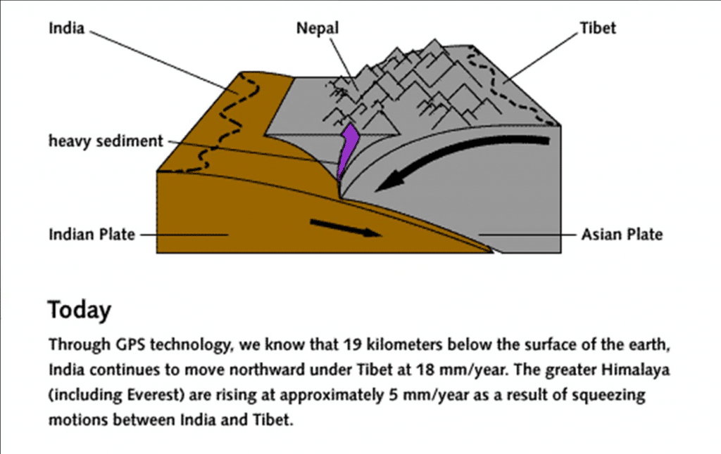
The Himalayan mountain range and Tibetan plateau have formed as a result of the collision between the Indian Plate and Eurasian Plate which began between 40 and 50 million years ago and continues today.
Because both these continental landmasses have about the same rock density, one plate could not be subducted under the other. The pressure of the impinging plates could only be relieved by thrusting skyward, contorting the collision zone, and forming the jagged Himalayan peaks.
Himalayas Formation
- The Himalayas are the youngest mountain chain in the world.
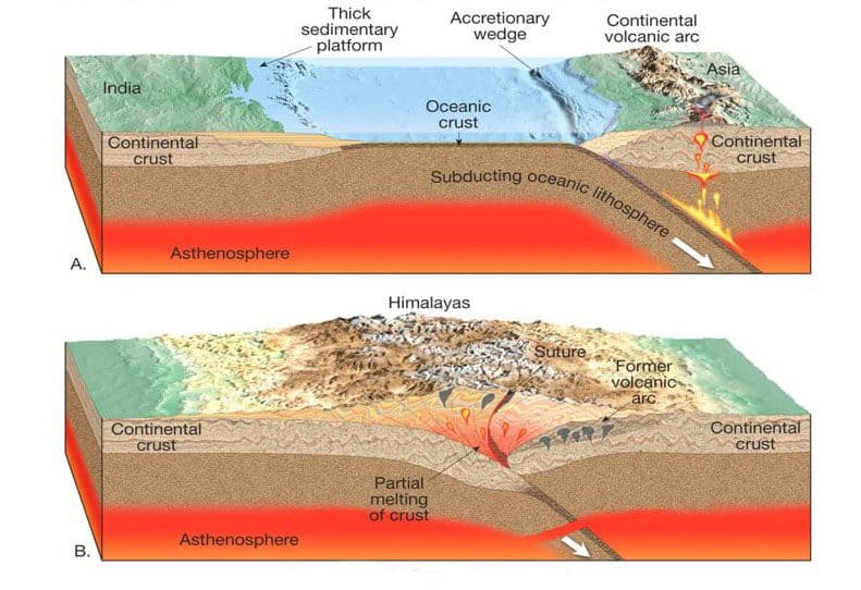
- Himalayan mountains have come out of a great geosyncline called the Tethys Sea and that the uplift has taken place in different phases.
- During Permian Period (250) million years ago, there was a supercontinent known as Pangaea.
- Its northern part consisted of present-day North America and Eurasia (Europe and Asia) which is called as Laurasia or Angaraland or Laurentia.
- The southern part of Pangaea consisted of present-day South America, Africa, South India, Australia, and Antarctica. This landmass was called Gondwanaland.
- In between Laurasia and Gondwanaland, there was a long, narrow, and shallow sea known as the Tethys Sea (all this was explained earlier in Continental Drift Theory).
- There were many rivers that were flowing into the Tethys Sea (some of the Himalayan rivers were older than the Himalayas themselves).
- Sediments were brought by these rivers and were deposited on the floor of the Tethys Sea.
- These sediments were subjected to powerful compression due to the northward movement of the Indian Plate. This resulted in the folding of sediments.
- An often-cited fact used to illustrate this process is that the summit of Mount Everest is made of marine limestone from this ancient ocean.
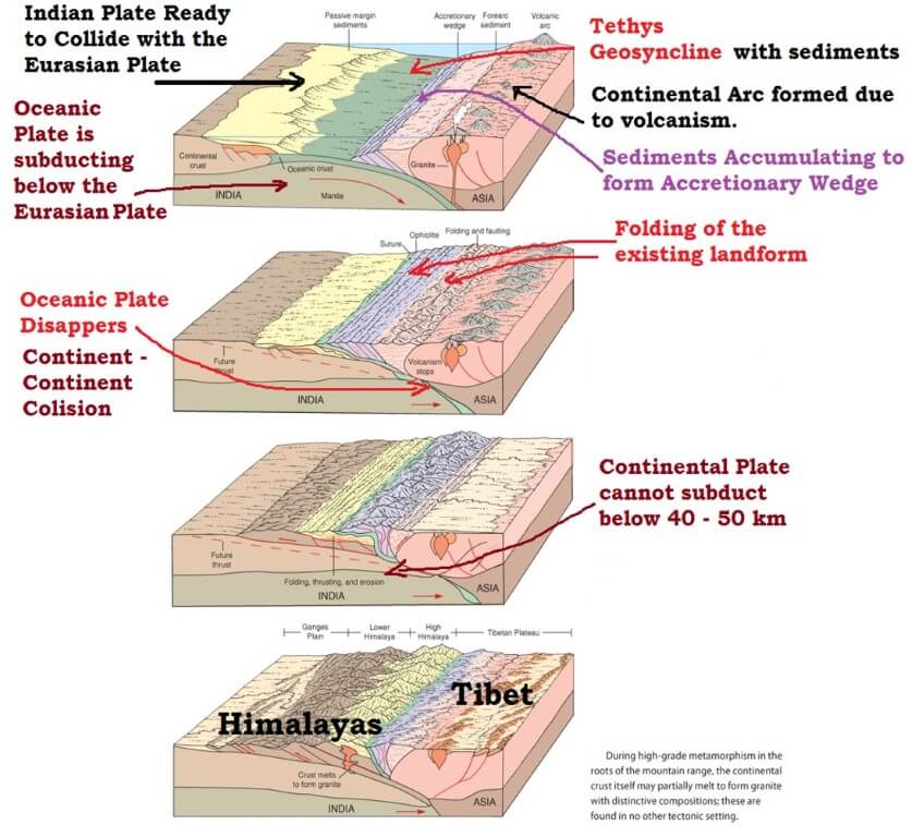
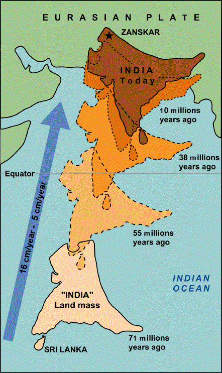
- Once the Indian plate started plunging below the Eurasian plate, these sediments were further folded and raised. This process is still continuing (India is moving northwards at the rate of about five cm per year and crashing into the rest of Asia).
- And the folded sediments, after a lot of erosional activity, appear as the present-day Himalayas.
- Tibetan plateau was formed due to upthrusting of the southern block of the Eurasian Plate.
- The Indo-Gangetic plain was formed due to the consolidation of alluvium brought down by the rivers flowing from the Himalayas.
- The curved shape of the Himalayas convex to the south is attributed to the maximum push offered at two ends of the Indian Peninsula during its northward drift.
Phases of Himalayas formation
The Himalayas do not comprise a single range but a series of at least three ranges running more or less parallel to one another. Therefore, the Himalayas are supposed to have emerged out of the Himalayan Geosyncline, i.e. the Tethys Sea in Six different phases following one after the other.
6 phases involved in the formation of Himalayas
- Phase 1 – 100 million years ago
- Phase 2 – 71 million years ago
- Phase 3 – The Drass volcanic arc
- Phase 4 – Greater Himalayas were raised
- Phase 5 – Rise of lesser Himalayas
- Phase 6 – Rise of the Shiwalik ranges
Phase 1 – 100 million years ago
- During Cretaceous Period, around 100 million years ago, the Indian plate was located b/w 10 ⁰ S – 40 ⁰ S, over the reunion hotspot
- The movement of the plate attained its mass velocity as it was closer to the equator (14cm/yr) and squeezing of the Tethys started towards the end of the Paleocene.
Phase 2 – 71 million years ago
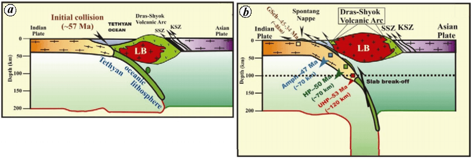
- Himalayan Orogenesis begins roughly about 71 million years ago and the plate with Gondwana continental piece drifted towards North East and the rigid Northwestern flangs composed of the Aravalli series collided with Eurasia.
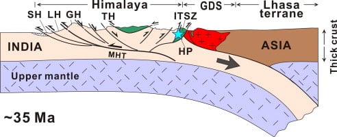
- The line of collision b/w the Tibetan Plateau and the Indian Plate is called (Indus–Tsangpo Suture Zone) which is a compressional tectonic fault line.
- As the plate began to subduct, crustal doubling below Tibet raised them into a high plateau with a thickness of around 60km
- Along the southern front of the ITSZ ( Indus-Tsangpo Suture Zone), the Murree Foredeep was formed and further south, the Shiwalik foredeep was created.
Orogenesis is the formation of mountains and orogeny is the process by which mountains are formed.
Suture zone is a linear belt of intense deformation, where distinct terranes or tectonic units with different plate tectonic, metamorphic, and paleogeographic histories join together.
Phase 3 – The Drass volcanic arc
- During Oligocene, the Drass volcanic area was formed and in the Tethys crust, a series of volcanic eruptions took place
- The plate has started anti-clock rotation and Drass became the Pivotal Axis
- Thus, in the western part, pressure and compression were gradually released but towards the East, squeezing of Tethyan sediments has started which marks the beginning of the rising of Tethyan.

Phase 4 – Greater Himalayas were raised
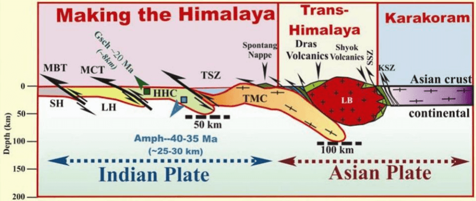
- The rotation continued and greater compression created a major thrust in the sediments of Murree foredeep and greater Himalayas were raised about 30-35 million years ago ( Oligocene to Eocene)
- The compressional thrust line is known as the Main Central Thrust (MCT).
Phase 5 – Rise of lesser Himalayas
- The sediments were being deposited in the Shiwalik foredeep and further movement in the plate resulted in the rise of lesser Himalayas during the Miocene (15-20 MYA)
- MCT separates greater and lesser Himalayas and the compressional thrust line along which the lesser Himalayas were lifted is called Boundary Thrust/Fault (MBT of MBF) line.
Phase 6 – Rise of the Shiwalik ranges
- In the Shiwalik foredeep, sedimentation by the Himalayan rivers fills up the molasse material.
- The partial feeding of the Shiwalik foredeep along the Himalayan Frontal Fault( HFF) led to the rise of the Shiwalik ranges which represent partially folded sedimentary range.
- Based on the tecto-geological history, the Himalayan relief and structure can be studied.
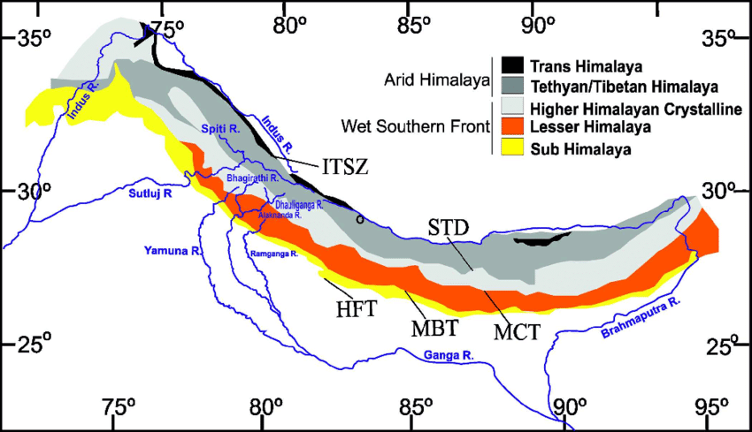
Relief and Structure of Himalayas
- Tibetan Plateau
- Indus –Tsangpo SutureZone
- Tethyan Himalayas
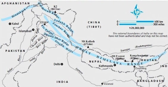
- Greater Himalayas
- MCT
- Lesser Himalayas
- MBF
- Shiwaliks
- HFF
- Indo Gangetic Basin
Tibetan Plateau
- Not a part of Himalayas, but formed due to Himalayan Orogeny
Indus- Tsangpo Suture Zone
- It is a compressional fault line that extends from the Indus gorge to the Tsangpo gorge almost for 3200 km.
- It represents the zone of plate collision where rocks are crushed, pulverized and mostly Paleozoic and ancient rocks are found.
- Presently, river Indus and river Tsangpo flow through the reverse faulted line of discontinuity (Suture – Line where two plates are welding).
Tethyan Himalayas
- The average height is 4000m
- It is compressed with Greater Himalayas and the absence of a longitudinal valley between them manifests the high compressional forces which have sandwiched them
- They have submarine, sedimentary, metamorphic rocks
- They represent initial upliftment in the Tethyan Geosyn or Murree foredeep.
Greater Himalayas
- The average height is 6000m
- Extends from Mt. Namcha Barwa to Nanga Parbat for 2500km
- The mightiest and the most majestic mountain range of the world, boasting of hundreds of peaks rising above 7000m
- High relief, deep gorges, vertical slopes, symmetrical convexity, and antecedent drainage mark the relief feature
- Due to iso-static adjustment and deep cutting of valleys, peaks are sharp and the valleys have escarps or free face.
- They are composed of metamorphic and sedimentary rocks.
- The core of the mountains has Batholith representing the intrusion of Magma (Granitic Magma)
- These mountains have asymmetrical folds due to high compression and they have fractured rocks in the eastern part because of the Indian Plate closed the Tethys like a door slamming shut.
Main Central Thrust (MCT)
- It makes the zone of Tectonic Thrust and the longitudinal axis along which the Greater Himalayas were lifted
- It’s a tectonic compressional valley.
- Rocks are fractured, pulverized and it forms a synclinal basin b/w the Greater Himalayas and the lesser Himalayas
- Kathmandu Valley, Kashmiri Valley, Kulu, and Kangra Valleys are examples of the Syncline basin
- Kulu is a transverse valley while Kangra and Manali are straight valley (These valleys are more prone to earthquakes due to fault beneath).
Lesser Himalayas
- The average height is 3800m, the length is about 2400kms, almost parallel to the Greater Himalayas but in the Western section, it is segmented into several parallel and transverse ranges
- Parallel Ranges – Pir Panjal, Dhaula Dhar
- Transverse Ranges – Ratan Pir, Nagtiba, Mussourie Range
- The central part in Nepal is called the Mahabharatha range and the eastern part is called the Dafla hills, Mishmi hills, Miri hills, Abor which are closely compressed with the Shiwaliks and difficult to isolate from Shiwalik Ranges
- Here the width of the Himalayas are much less than in the western section and the structure is complex with fracture, fault, pulverization of rocks.
Main Boundary Fault (MBF)
- This is the longitudinal axis along with the second major thrust in the Himalayas acted. However, it is not as deep as MCT. It is also a compressional fault line
- MCT is low angle reverse fault while MBF is a wide-angle reverse fault
- Thus, the valleys are wide and the rivers formed lakes in the valleys where Lakestrene sediments were deposited.
- Once the rivers were able to cut through the Shiwaliks they developed their course and these Lakestrene sediments formed the alluvial planes known as Doons. Example: Dehra dun, Patli dun
- The wide longitudinal valleys in b/w the lesser Himalayas and Shiwaliks are called “Doons” in western and central Himalayas and “Duars” in Eastern Himalayas.
Shiwaliks
- The average height is 800-1200m
- They are partially folded and formed of river sediments deposited in the foredeep
- They represent Hogback topography and the 300m contour line demarcates their boundary with the Gangetic Plain.
- In the western section, it is called Shiwalik
- In Nepal, it is called Churiaghat hills and in Assam, it is called Mishmi, Abor, Dafla, etc (same as in lesser Himalayas)
- Closer to Greater Himalayas in Nepal – Disappear after River Ganges.
Himalayan Frontal Fault (HFF)
- This marks the boundary b/w the Himalayan ranges and the Gangetic basin
- It is a wide-angle thrust line where the last compressional force in the Himalayas Orogeny has taken place.
[amazon box=”B08B8PRDHC”]

Good Content .. if PDF avail would be good
Buy his course and you will get it . This person is helping us a lot so least we can do is buying his courses which are so economical compare to this material’s quality … we have to understand that one cannot run free website for long if we can’t provide atleast minimal amount of fee for his work by purchasing his work
blog content is really good….. Really enjoyed of reading it.
Love this content…Useful and easily understandable contenet…Keep it up sir…
useful content
I like this…really helpful congrats to Lotusarise team
this is the best and very comprehensive yet brief explanation. Thank you so much. It helped me tremendously.
Sir,in NCERT it’s written that Indian plate density is more, and it’s subducting.
Yup, recent data shows that Indian plate is subducting under Eurasian plate
thank u for writing this content its helping me in my exams…
Keep reading, and Keep Supporting Guys👍.