

- The Indian rock system is the fourfold age classification of the country’s rocks: Archaean, Purana, Dravidian and Aryan. India holds rocks from almost every geological age, from gneisses more than 3.4 billion years old to alluvium still being laid down.
- The geological structure of a country explains the types and character of its rocks and slopes, the physical and chemical properties of its soils, the availability of minerals, and its surface and underground water.
- This makes geology a practical guide to farming, industry, land-use planning, transport routes, irrigation, groundwater use and hazard management (earthquakes, landslides, floods).
- The alluvial Indo-Gangetic plain has fertile soils but almost no minerals.
- The plateau’s crystalline rocks, especially at Chotanagpur, are rich in minerals.
Geological Structure and Time
Key Terms
- Geological structure: how rocks are laid down and arranged in the earth’s crust, as a result of earth movements or their absence.
- The term is also used for the morphological features of rocks, for example Gondwana structure.
- Geological time scale: the chronological dating of geological formations (strata) and of life, according to their time and place of origin, evolution and extinction.
- Giovanni Arduino (1759–60) laid its foundation by sorting the strata of northern Italy into four orders: Primary, Secondary, Tertiary and a fourth, later called Quaternary.
- The second International Geological Congress at Bologna, Italy (1881) formally set up the standard hierarchy of time units.
- The units run from longest to shortest: eon, era, period, epoch.
- The Precambrian makes up about 88% of geological time.
- Indian geological time scale: advocated by Sir Thomas Henry Holland, Director of the Geological Survey of India from 1903 to 1910.
- It gave India its own names for the four major divisions, because Indian rock successions match the European scheme only in part.
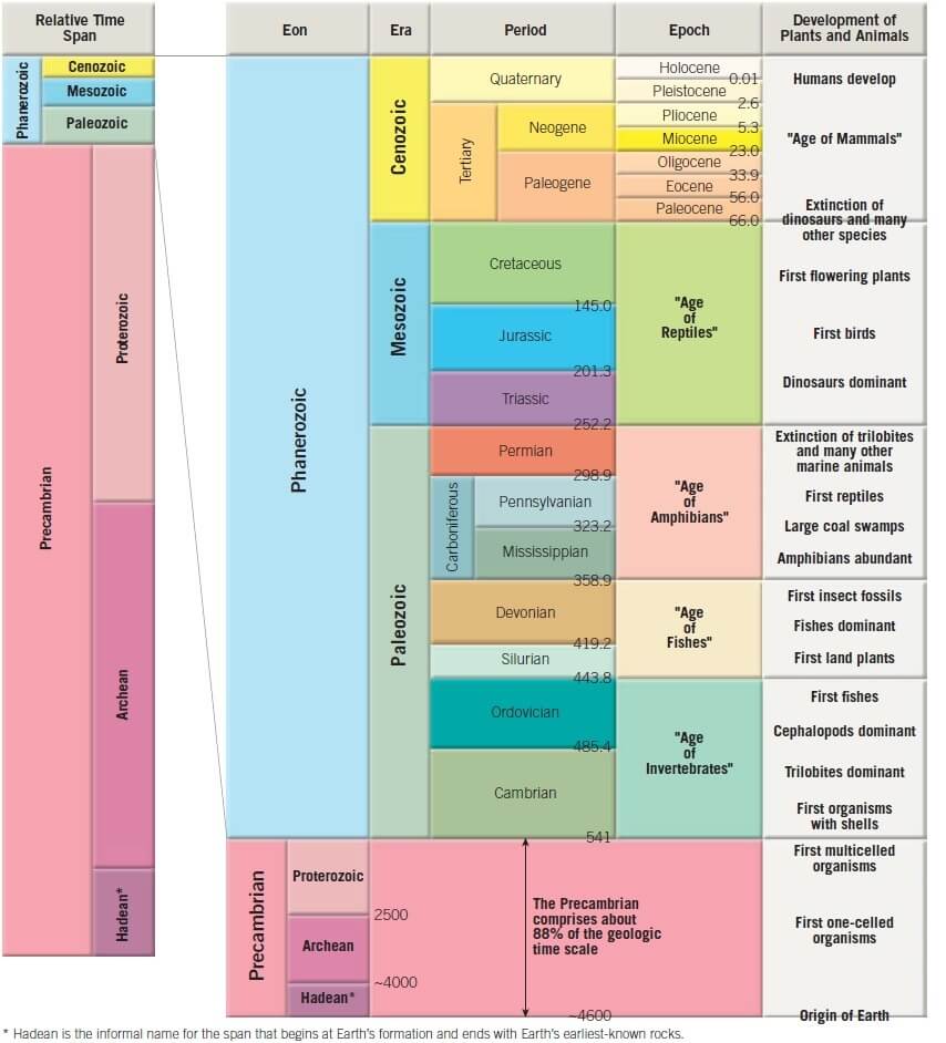

- The table sets the current international dates beside the older figures still found in Indian accounts.
| Era or eon | Period | Began (million years ago, ICS 2026) | Older Indian figure | Indian system |
|---|---|---|---|---|
| Cenozoic | Quaternary | 2.58 | about 1 | Aryan |
| Cenozoic | Neogene | 23.03 | Tertiary: 60–7 | Aryan |
| Cenozoic | Palaeogene | 66.0 | Tertiary: 60–7 | Aryan |
| Mesozoic | Cretaceous | 143.1 | 135–70 | Aryan |
| Mesozoic | Jurassic | 201.4 | 180 | Aryan |
| Mesozoic | Triassic | 251.9 | 280–225 | Aryan |
| Palaeozoic | Permian | 298.9 | 250 | Aryan |
| Palaeozoic | Carboniferous | 358.9 | 350 | Dravidian, Aryan from the Upper Carboniferous |
| Palaeozoic | Devonian | 419.6 | 400 | Dravidian |
| Palaeozoic | Silurian | 443.1 | 440 | Dravidian |
| Palaeozoic | Ordovician | 486.9 | 500 | Dravidian |
| Palaeozoic | Cambrian | 538.8 | 600 | Dravidian |
| Proterozoic eon | Pre-Cambrian | 2,500 | Purana: 1,400–600 | Purana |
| Archaean eon | Pre-Cambrian | 4,031 | about 4,000 | Archaean |
Geological Regions of India
- The rock systems of India are read against its physiographic divisions. The threefold division is the one generally accepted.
- Some scholars recognise only two: the Peninsular block and an Extra-Peninsular region that takes in both the Himalaya and the Indo-Gangetic plain.
| Feature | Peninsular India | Extra-Peninsular India | Indo-Gangetic plain |
|---|---|---|---|
| Extent | The plateau, plus the Meghalaya plateau and Kachchh–Kathiawar | The Himalaya and its eastern extensions, including the Andaman and Nicobar Islands | The great trough between the other two |
| Origin | One of the oldest landmasses on earth | Raised from the Tethys Sea | Aggradation by Himalayan and Peninsular rivers |
| Stability | Rigid block, little affected by tectonic forces; its interior has escaped marine submergence since the Cambrian | Weak, flexible crust: folded, faulted, overthrust and prone to severe earthquakes | Subsiding foredeep, still being filled |
| Relief | Open, senile | Youthful | Flat, featureless |
Major Events in India’s Geological History
- Peninsular India has been part of the old landmass since the formation of the earth’s crust.
- The Indian craton, the block of the subcontinent within Gondwanaland, later became part of the supercontinent Pangaea.
- Gondwanaland’s breakup and India’s northward drift towards the Eurasian craton:
- The figure of 225 million years ago often quoted for the breakup marks the first rifting of Pangaea. India’s own separation came in stages.
- India and Madagascar left East Africa about 160 million years ago and Antarctica about 130 million years ago.
- India separated from Madagascar about 88 million years ago and from the Seychelles about 64 million years ago.
- As part of this continental drift, the Arabian Sea and the Bay of Bengal took shape. The straight outlines of the coasts are linked to this faulting, a view associated with Eduard Suess.
- Upheaval of the Himalaya in the Tertiary period.
- The older figure of 65 million years ago for its start is now usually narrowed to a collision with Asia at about 60–55 million years ago, though estimates vary.
- Three later pulses raised the Greater Himalaya, the Lesser Himalaya and the Shiwaliks in turn.
- Aggradation of the Indo-Gangetic-Brahmaputra plain began in the Upper Pliocene and Pleistocene, after the Outer Himalaya had risen.
- It continues today through sedimentation in the floodplains of rivers and in the lower Gangetic plain.
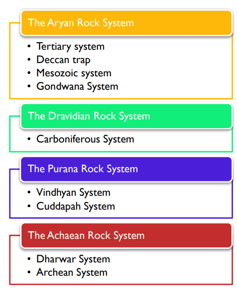
The Fourfold Classification
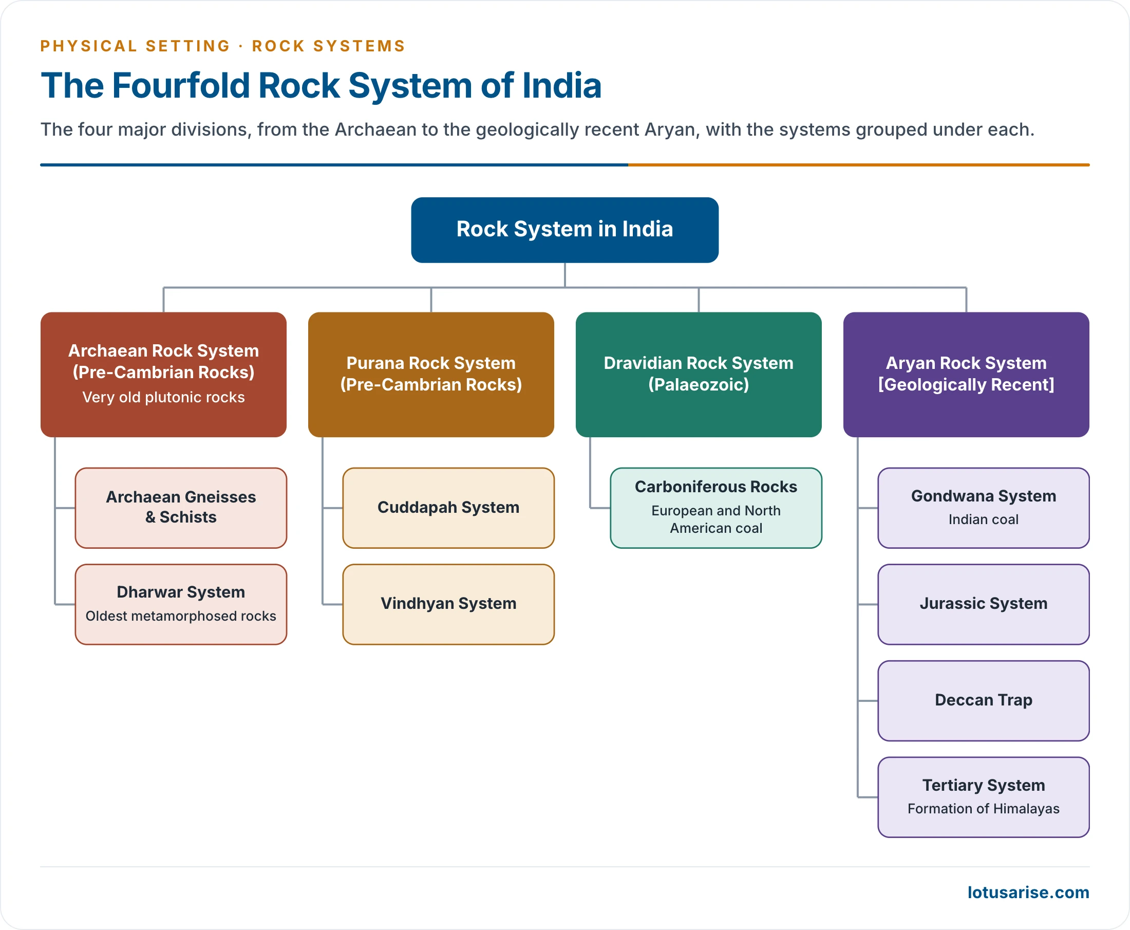
- From this complex history, the Geological Survey of India classifies the country’s rocks into four major divisions:
- The Archaean Rock System
- The Purana Rock System
- The Dravidian Rock System
- The Aryan Rock System
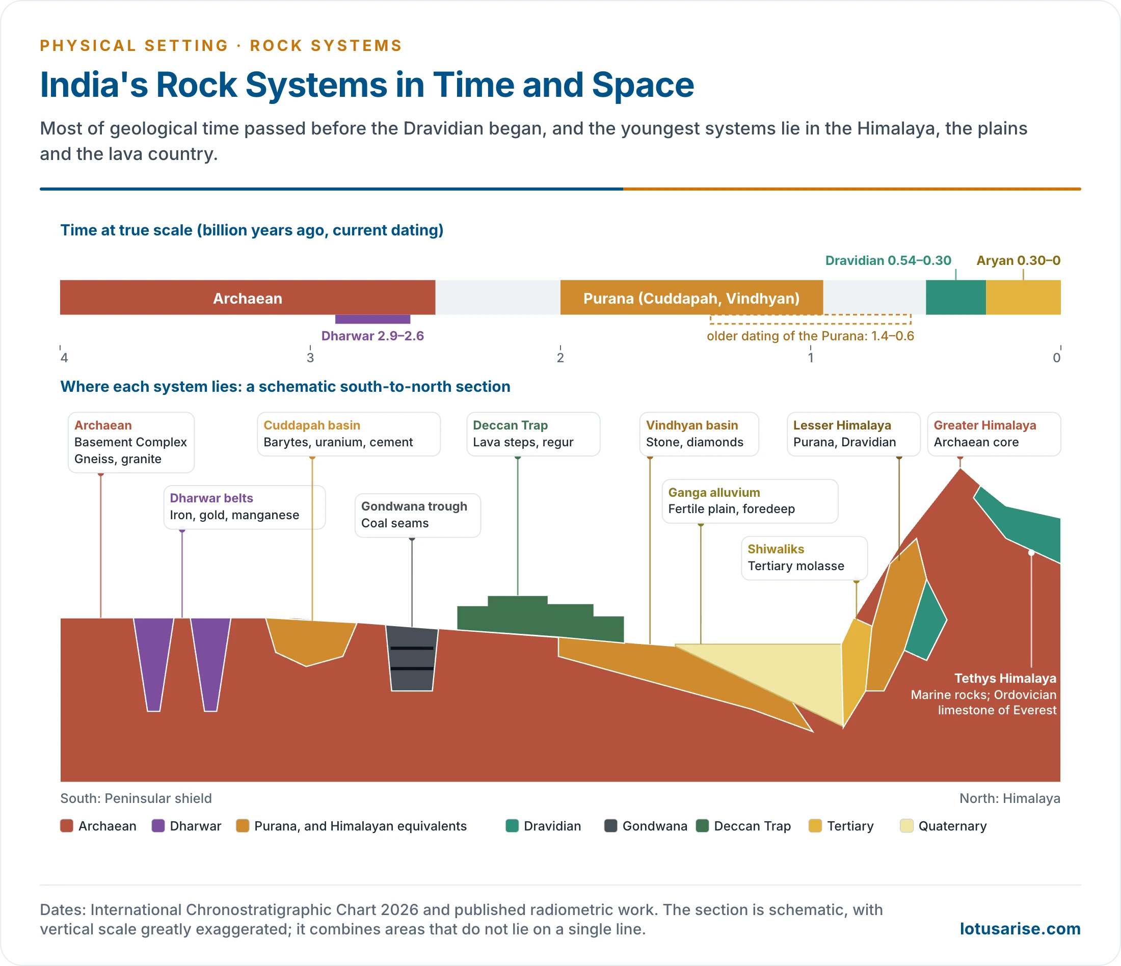
| System | Older dating | Current dating | Main rocks | Chief areas | Economic value |
|---|---|---|---|---|---|
| Archaean gneisses and schists | about 4,000 Ma | mostly 3,600–2,500 Ma | Gneiss, granite, schist | Two-thirds of the Peninsula, Himalayan core | Mica, copper, lead, zinc, silver |
| Dharwar | 3,100–2,300 Ma | about 2,900–2,600 Ma | Schist, quartzite, phyllite | Karnataka, Chotanagpur, Odisha, Aravalli | Iron, manganese, gold, copper |
| Cuddapah | 1,400–600 Ma | from about 2,000 Ma | Quartzite, shale, limestone | Andhra Pradesh, Chhattisgarh | Uranium, barytes, asbestos, cement limestone |
| Vindhyan | 1,300–600 Ma | from before 1,600 to about 950 Ma | Sandstone, shale, limestone | Sasaram to Chittaurgarh | Building stone, diamonds, limestone, glass sand |
| Dravidian | 600–300 Ma | 539–299 Ma | Fossiliferous shale, slate, quartzite | Himalaya, Salt Range | Little in India |
| Gondwana | from 250 Ma | from about 299 Ma | Sandstone, shale, coal | Damodar, Mahanadi, Godavari | Over 99% of India’s coal |
| Deccan Trap | end-Cretaceous to Eocene | about 66.4–65.4 Ma | Basalt | Maharashtra, Malwa, Saurashtra | Regur soil, road metal, agate |
| Tertiary | 60–7 Ma | 66–2.58 Ma | Sandstone, clay, limestone | Himalayan foothills, Assam, coasts | Petroleum, Tertiary coal, lignite |
| Quaternary | last 1 million years | last 2.58 million years | Alluvium, loess, moraine | Northern Plains, Karewas | Fertile soils, groundwater |
Archaean Rock System (Pre-Cambrian Rocks)
- The earliest phase of tectonic evolution saw the upper crust cool and harden, in the Archaean, before about 2.5 billion years ago, within the Precambrian.
- It is represented by the exposure of gneisses and granites, especially on the Peninsula.
- These rocks form the core of the Indian craton.
- India’s oldest crustal blocks are now named as cratons: Dharwar, Bastar, Singhbhum, Bundelkhand and Aravalli.
- The term Archaean was introduced by James Dwight Dana in 1872 for the oldest rocks of the earth’s crust.
- The Archaean group has two systems:
- Archaean system: granites and gneisses.
- Dharwar system: the first sedimentary rocks, now metamorphosed.
Archaean Gneisses and Schists
- Gneiss: mineral composition varies from granite to gabbro, with a foliated or banded structure. It is the commonest Archaean rock.
- Schists: mostly crystalline, and include mica, talc, hornblende, chlorite, epidote, sillimanite and graphite schists.
- These rocks are:
- The oldest rocks, of the Pre-Cambrian, classically placed at about 4 billion years.
- The oldest dated rocks of India are about 3.5–3.6 billion years old, in the Singhbhum craton. Zircon grains inside them reach 4.24 billion years, so still older crust once existed.
- Formed when the first molten crust solidified on a very hot earth. Much of it was later melted again and metamorphosed into gneiss.
- Known as the Basement Complex or Fundamental Complex, because they are the oldest rocks and form the base for all later layers.
- Azoic or unfossiliferous.
- Foliated, consisting of thin sheets.
- Thoroughly crystalline, from slow cooling at depth and from high-grade metamorphism.
- Intruded by plutonic rocks, which are igneous rocks that solidified deep inside the crust. Contorted and faulted throughout.
- The oldest rocks, of the Pre-Cambrian, classically placed at about 4 billion years.
- Distribution:
- They cover about two-thirds of the Peninsula: its central and southern parts, Odisha, Meghalaya, Madhya Pradesh, Chhattisgarh, the Chotanagpur plateau and all of Bundelkhand.
- They appear as isolated outcrops from north of Vadodara along the Aravalli.
- They also make up the crystalline core of the Himalaya’s high ranges.
- Three Peninsular types are commonly separated:
| Type | Character | Areas |
|---|---|---|
| Bengal gneiss | Thinly foliated; includes the khondalites, named after the Khond people | Eastern Ghats, Odisha, Hazaribagh, Nellore, Salem, Meghalaya |
| Bundelkhand gneiss | Massive, coarse, granite-like, criss-crossed by quartz veins | Bundelkhand, Baghelkhand, parts of Rajasthan and the south |
| Nilgiri gneiss (charnockite) | Dark, plutonic; named after Job Charnock, whose Kolkata tombstone is cut from it | Nilgiri, Palni and Shevaroy hills, Nellore, Balasore |
Dharwar System
- Age:
- Older accounts gave a very wide span, about 4 to 1 billion years ago. The sedimentary cycles were placed at 3,100–2,300 million years, with metamorphism about 1,000 million years ago.
- Dating now places the Dharwar Supergroup at about 2.9–2.6 billion years, above an older Sargur Group of about 3.35–3.2 billion years.
- Origin: a highly metamorphosed sedimentary rock system, formed from the sediments of eroded Archaean gneisses and schists, with some metamorphosed igneous rock.
- Darashaw Nosherwan Wadia treated them as India’s most ancient metamorphosed sedimentary system.
- They are the oldest metamorphosed rocks of the classification and are often hard to tell from their original forms.
- Rocks: hornblende schist, quartzite, phyllite, slate, crystalline limestone and dolomite.
- Distribution:
- Found in abundance in the Dharwar (Dharwad) district of Karnataka, which gives the name, and in the Dharwar–Bellary–Mysore belt.
- Jharkhand: Ranchi, Hazaribagh. Madhya Pradesh: Balaghat, Rewa.
- Chhattisgarh: Bastar, Dantewada, Kanker. Odisha: Sundargarh, Keonjhar.
- The Aravalli between Jaipur and Palanpur, the central and northern Himalaya, and the Meghalaya plateau.
- These are India’s economically richest rocks, carrying high-grade iron ore, manganese, copper, lead and gold, along with quartzite, slate and mica.
- Gold: the Champion series of the Kolar field, closed in 2001, and Hutti in Karnataka, still worked.
- Iron ore: the Iron Ore series of Singhbhum, Keonjhar and Bonai, feeding Jamshedpur, Durgapur, Rourkela and Bokaro, and Bellary–Hospet in Karnataka.
- Marble: the Raialo series (Makrana) and the green marble of the Champaner series. Both are now usually treated with the separate Aravalli–Delhi sequences.
- Other series: Chilpi, Sakoli and Sausar in central India, and the Khondalite series of the Eastern Ghats.

- On this map, the belt labelled “metamorphic” for Gondwana and Vindhyan is in fact mainly sedimentary.
Purana Rock System
- The Cuddapah and Vindhyan rock systems together form the Purana rock system. In India, Purana stands in for Proterozoic.
- They are formed by the erosion and deposition of Archaean and Dharwar rocks.
- The process was long placed between 1,400 and 600 million years ago. Radiometric dating now pushes both basins much further back, as shown below.
- They are mostly sedimentary and far less metamorphosed than the Dharwars.
Cuddapah System
- Named after the Cuddapah (Kadapa) district of Andhra Pradesh, where outcrops of these rocks were first studied and are best developed.
- Formation: sandstone, limestone, clay and slate settled in synclinal basins, classically described as lying between two mountain ranges.
- A great unconformity separates them from the Dharwars.
- They reach about 6,100 m in thickness at places, with several breaks in deposition.
- Age: dating now puts the start of sedimentation near 2,000 million years ago, with the younger Kurnool rocks in the Neoproterozoic. Older accounts started the system at 1,400 million years.
- Distribution:
- The largest outcrop lies in the Cuddapah and Kurnool districts: a crescent of about 45,000 sq km, concave towards the coast. Its shape suggests compression from the eastern side.
- Southern Chhattisgarh: Dantewada, Bastar, Kanker, Dhamtari, Raipur, Durg and Rajnandgaon.
- Isolated exposures: Singhbhum in Jharkhand, Kalahandi and Keonjhar in Odisha, and Karnataka.
- The Aravalli axis from Delhi to Idar in Gujarat, about 5,200 m thick at places.
- Economic significance:
- Ores of iron, manganese, copper, cobalt and nickel, often low in grade.
- Barytes, asbestos, steatite, jasper and chert.
- Large deposits of cement-grade limestone, and quartzite for building.
- Uranium: the strata-bound Tummalapalle deposit lies in the dolostone of the Vempalle Formation.
- Fossils are largely absent, though stromatolites occur in the Vempalle and Tadpatri formations.
Vindhyan System (1300-600 million years)
- The system takes its name from the Vindhyan mountains, though Oskar Spate was careful to separate the rocks from the hills.
- It comprises ancient sedimentary rocks, about 4,000 m thick, resting on the Archaean base: sandstones, shales and limestones.
- It is mostly unfossiliferous, with only a few traces of life, and a large area of the belt lies under the Deccan Trap.
- Distribution:
- It covers over 1,00,000 sq km from Sasaram and Rohtas in Bihar to Chittaurgarh in Rajasthan, with a gap at Bundelkhand. It is widest between Agra and Neemuch.
- The Great Boundary Fault divides it from the Aravalli.
- It also occurs in Chhattisgarh, the Bhima valley and Kurnool, and continues beneath the Gangetic alluvium.
- Two divisions, separated by an unconformity:
| Division | Older dating | Current dating | Origin and form | Groups and areas |
|---|---|---|---|---|
| Lower Vindhyan (Semri) | 1,300–1,100 Ma | about 1,630 Ma for its volcanic layers | Marine, calcareous, folded in places | Son valley, Chhattisgarh, Bhima valley, Mewar |
| Upper Vindhyan | 1,000–600 Ma | closing about 950 Ma | Fluvial and shallow-water, in undisturbed horizontal beds | Kaimur, Rewa, Bhander |
- Economic significance:
- Diamonds: its diamond-bearing horizons gave the famous Panna and Golconda stones.
- Panna’s placer horizons lie in the Upper Vindhyan. The Majhgawan pipe, India’s only mechanised diamond mine, is an intrusion of about 1,070 million years cutting the Kaimur sandstone.
- The Golconda name belongs to stones of the Krishna valley. Its region includes the diamond-bearing Banganapalle conglomerate of the Kurnool Group, the Vindhyan equivalent in the south.
- It is devoid of metalliferous minerals of any worth, but gives large quantities of durable and ornamental stone, flagstone, limestone and pure glass-making sand.
- Its red sandstone built the Sanchi stupa, Fatehpur Sikri, Agra Fort, Humayun’s Tomb and the Red Fort.
- Diamonds: its diamond-bearing horizons gave the famous Panna and Golconda stones.
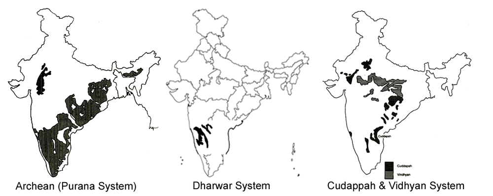
- On this map, the left panel shows the Archaean rocks. The word “Purana” in its label is a slip.
Dravidian Rock System (Palaeozoic)
- The Palaeozoic rock formations of India are called the Dravidian system.
- They were dated to 600–300 million years ago. The Palaeozoic is now placed at about 539–252 million years, the Dravidian part ending near 299 million years.
- The system is sometimes loosely called the Carboniferous rock system, after the high-quality coal formed in that period elsewhere in the world. That name fits only its last part.
- Distribution:
- The rocks are mostly Extra-Peninsular, in the Himalaya. The Gangetic plain has no outcrop, since its alluvium conceals what lies below.
- They are very scarce on the Peninsular shield, with small Lower Permian patches near Umaria, in the former Rewa State.
- Major areas: Pir Panjal, Handwara, Lidder valley and Anantnag in Kashmir; Spiti, Kangra and Shimla in Himachal Pradesh; Garhwal and Kumaon in Uttarakhand; and the Salt Range.
- Rocks: mainly shales, sandstones, clays, quartzites, slates, salts, talc, dolomite and marble.
- Pangaea and Tethys:
- Pangaea was assembled towards the end of this era, not broken. Its breakup came later, in the Mesozoic.
- The Tethys Sea, named by Eduard Suess (1893), lay along the northern edge of Gondwana. Its sediments form these Himalayan rocks.
- Life:
- The era marks the first abundance of shelly fossils, not the beginning of life, which reaches far back into the Precambrian.
- Plenty of fossil evidence appears in all formations of this time and shows marine conditions. It allows rocks to be dated and matched across distant areas.
- Coal: the Dravidian period saw the beginning of coal formation, with high-quality Carboniferous coal. These formations are not abundant in India.
- The system includes the rocks of five geological ages:
| System | Origin of name | Older date (Ma) | Rocks and Indian occurrence |
|---|---|---|---|
| Cambrian | Cambria, the Latin name for Wales | 600 | Haimanta system of Spiti (1,600 m), Kullu, Lahaul, Baramulla, Kumaon. Saline series of the Salt Range (900 m of fossil-bearing rock above salt marl) |
| Ordovician | The Ordovices, a people of Wales | 500 | Quartzite, grit, sandstone and limestone in Spiti, Lidder valley and Kumaon |
| Silurian | The Silures, on the Wales–England border | 440 | Spiti, a thin band around the Lidder anticline, Lahaul, Kullu, Kumaon |
| Devonian | Devon in England | 400 | Fossils and corals elsewhere, but the massive white Muth Quartzite (up to 900 m) of Spiti and Kumaon is almost barren. Also Lidder and Haridwar |
| Carboniferous (Lower and Middle) | “Coal-bearing” | 350 | Spiti, Kashmir, Shimla, the eastern Himalaya; Pir Panjal trap |
Carboniferous Rocks (350 million years)
- The Carboniferous rocks, about 350 million years old, are mainly limestone, shale and quartzite.
- They divide into Lower (slates, Pir Panjal trap), Middle (an age of great upheavals) and Upper (limestone and dolomite) groups.
- Mount Everest has long been described as Upper Carboniferous limestone.
- The summit rock is now identified as Ordovician limestone, the Qomolangma Formation, which carries fragments of trilobites and crinoids.
- Coal formation began in this age, and the name itself means coal-bearing.
- Most Indian coal is not Carboniferous.
- High-quality Carboniferous coal belongs to the USA (the Appalachian and Illinois basins, east and south of the Great Lakes), the UK and the Ruhr region.
Aryan Rock System
- The Aryan group begins in the Upper Carboniferous and runs to the Holocene: the last, longest and most eventful era of India’s geological history.
- It is fairly preserved in the Peninsula and appears in near-perfect sequence along the Himalayan border.
- The Aryan group is classified as follows:
| Era | Older epoch label | Periods | Indian formations |
|---|---|---|---|
| Upper Palaeozoic | Upper Primary | Upper Carboniferous and Permian | Lower Gondwana |
| Mesozoic | Secondary | Triassic, Jurassic and Cretaceous | Gondwana rock system, Jurassic system, Deccan Trap |
| Cenozoic | Tertiary | Paleocene, Eocene, Oligocene–Miocene and Pliocene | Tertiary system |
| Neozoic (an old label; the Quaternary now falls within the Cenozoic) | Quaternary | Pleistocene and Holocene (Recent) | Alluvium, Karewas, moraines |
Gondwana System
- Name: from Gondwana, “the land of the Gonds”, the region of central India named after the Gond people, who also live in parts of Telangana and Andhra Pradesh.
- Henry Benedict Medlicott applied it to these rocks in 1872. Eduard Suess extended it to the supercontinent Gondwanaland in 1885, on the evidence of the Glossopteris flora.
- Origin:
- The sediments were laid down in synclinal troughs on the ancient plateau surface. These are now understood as fault-bounded basins.
- As sediment accumulated, the loaded troughs subsided, keeping pace with deposition.
- Fresh water and sediment collected in these troughs, and terrestrial plants and animals thrived and were buried there.
- The deposits are river and lake beds, about 6,000 m thick, and record several climatic changes.
- Age: this happened from the Permian. Older accounts say 250 million years ago, but the Permian began about 299 million years ago, and sedimentation continued into the Early Cretaceous.
- Divisions: the coal lies in the Lower Gondwana. Talchir at the base is glacial, and the Damuda series above it holds the main seams. The Panchet above them has no coal.
- Distribution:
- Peninsula: the Damodar valley in Jharkhand and West Bengal, the Mahanadi valley in Chhattisgarh and Odisha, southern Madhya Pradesh, and a chain of troughs along the Godavari from Nagpur to the delta.
- Himalaya: Kashmir, Darjeeling and Sikkim, where the beds are so strongly deformed that they look quite unlike their Peninsular counterparts.
Gondwana Coal
- Gondwana rocks hold nearly 98% of India’s coal reserves in older accounts.
- The latest national inventory (1 April 2025) puts the share higher: 399.0 billion tonnes of a total 400.7 billion tonnes, about 99.6%. Tertiary coal makes up the remaining 1.7 billion tonnes.
- Gondwana coal is much younger than Carboniferous coal, and so its carbon content is low.
- It runs from thin seams to the exceptional 134 m seam at Singrauli.
- The rocks also have deposits of iron ore, copper, uranium and antimony. The ironstone shales of Raniganj are low in grade and rarely mined.
- Sandstones, slates and conglomerates serve as building materials, and fire clay and kaolin feed the ceramic industry.
Triassic System
- Almost unknown in the Peninsula, it extends from Hazara to Nepal, with fine sections on the southern flank of the Great Himalaya from Kashmir to eastern Kumaon.
- Its name means threefold, for its three divisions:
- Lower: over 100 m in Kashmir, 50 m at Byans, 12 m in Spiti.
- Middle: 275 m in Kashmir.
- Upper: 1,200–1,800 m of well-bedded limestone in Kashmir. In Spiti, the middle and upper parts total about 1,000 m, largely calcareous.
Jurassic System
- It takes its name from the Jura mountains on the France–Switzerland border.
- Himalayan belt: it covers wide areas in Tibet, southern Ladakh, Spiti, Nepal and Bhutan, with limestone 600–900 m thick. The Spiti shales are known for their ammonites.
- Marine transgression in the later Jurassic left thick shallow-water deposits in Rajasthan (Jaisalmer) and Kachchh.
- Coral limestone, oolitic limestone, sandstone, conglomerates and shales occur in Kachchh, over an area of about 190 km by 64 km.
- A second advance of the sea reached the east coast between Guntur and Rajahmundry, where marine beds alternate with Upper Gondwana rocks.
Cretaceous System
- The name comes from creta, Latin for chalk. It is the most widely spread of the systems across both the Peninsula and the Extra-Peninsula, and among India’s fullest marine records.
- Himalayan and north-eastern rocks:
- Spiti: sandstones, quartzites, limestones and shales.
- Kumaon: sandstones and shales. Rupshu and Burzil: limestones.
- Meghalaya: sandstones. The Lower Mahadek sandstone of the East Khasi Hills carries uranium.
- Peninsular rocks:
- Pondicherry–Tiruchirappalli belt: Upper Cretaceous marine beds, whose limestone feeds the cement plants of Ariyalur.
- Bagh Beds: marine outcrops along the Narmada valley, beneath the Deccan Trap.
- Lameta Beds: river and lake deposits of central India, lying under the Trap and famous for dinosaur remains.
Deccan Trap
- Origin: a volcanic outburst over a vast area of Peninsular India, between the close of the Cretaceous and the opening of the Eocene, gave rise to the Deccan Traps.
- Basaltic lava flowed out of fissures, burying the old topography over about ten lakh sq km. Recent work treats this as a minimum.
- Current dating places the bulk of the eruptions at about 66.4–65.4 million years ago, across the Cretaceous–Palaeogene boundary (66.0), in a total of more than 1.3 million cubic km. India then lay over the Réunion hotspot.
- Its share in the end-Cretaceous extinction, beside the Chicxulub impact, remains debated.
- Name: these deposits have flat tops and steep sides, and so are called “trap”, from the Swedish for a stair or step.
- Oskar Spate preferred the term Deccan Lava.
- Extent: weathering and erosion over millions of years have reduced the Trap to almost half its original size.
- About 5 lakh sq km survives today, chiefly across Kachchh, Saurashtra, Maharashtra, the Malwa plateau and northern Karnataka.
- Outliers occur in Telangana, Tamil Nadu, Jharkhand and Uttar Pradesh.
- Thickness: 3,000 m along the western coast near Mumbai, falling to 600–800 m towards the south, 800 m in Kachchh and only 150 m at Amarkantak at the eastern limit.
- Single flows vary from under a metre to 36 m. Some hills exceed 1,200 m in height.
- Value:
- Weathering of these rocks over a long time has produced black cotton soil, known as regur. The soil’s types and distribution follow from this parent rock.
- Basalt is the main rock, with dolerite, rhyolite and gabbro. It yields quartz, agate, calcite, building stone and road material.
- The lava plateau makes up the north-western Deccan.
- Three groups are recognised within the Trap:
| Group | Found in | Thickness | Inter-trappean beds | Layers of volcanic ash |
|---|---|---|---|---|
| The Upper Trap | Maharashtra and Saurashtra | about 450 m | Present | Present |
| The Middle Trap | Central India and Malwa | about 1,200 m | Very rare to absent | Present |
| The Lower Trap | Central India, with outliers to the south | about 150 m | Present | Very rare to absent |
- Current work on the Western Ghats section names three subgroups instead, from the base up: Kalsubai, Lonavala and Wai.
Tertiary System
- Age: Eocene to Pliocene, classically about 60 to 7 million years ago. The Tertiary is now dated from 66 to 2.58 million years ago.
- Two events mark it: the final breaking up of old Gondwanaland and the uplift of the Tethys geosyncline as the Himalaya.
- This is the pivotal period of India’s geology: the Himalaya rose and the country took its present shape.
- It is also called the Age of Mammals, for the abundance of their fossil remains.
- Spread: the Tertiary succession is fully spread over the Bengal and Ganges delta, the east coast and the Andaman Islands.
- It also occurs in the Salt Range, Potwar Plateau, the outer Himalaya of Jammu and Punjab, Assam, Sind and Baluchistan.
- Three divisions:
- Eocene (about 60 million years ago):
- Jammu to Shimla and Mussoorie, and the southern flank of the Pir Panjal.
- Rajasthan: lignite. Gujarat: Kachchh, Surat and Bharuch. Some deposits at Puducherry.
- North-East: limestones and coal-bearing sandstones of the Jaintia series in Meghalaya, the Barail series of the Surma valley and Naga Hills, and the Tertiary coal of Upper Assam.
- Oligocene and Lower Miocene (about 40–25 million years ago):
- The Oligocene is poorly developed, because denudation removed much of it. It survives in the Barail series, under a marked unconformity.
- The Miocene is fully developed: the Murree series of Jammu (25–40 km wide from the Indus to the Chenab) passes into the Dagshai–Kasauli band of Shimla, about 2,600 m of red clay and sandstone.
- The Surma series of Assam overlies the Barail, and the Garo Hills deposits have many marine fossils.
- Rocks of this group also occur in Kachchh, Mayurbhanj, Durgapur and Kollam.
- Shiwalik system (Middle Miocene to Lower Pleistocene, about 14 to 0.2 million years ago):
- Named after the Shiwalik hills between the Ganga and the Yamuna.
- Sandstones, grits, conglomerates, clays and silts up to about 5,000 m thick, laid down by rivers. Most are barren, but some beds are richly fossiliferous, and mammal fossils have been known from near Haridwar since the 1830s.
- Eocene (about 60 million years ago):
| Division | Thickness | Rocks | Age |
|---|---|---|---|
| Upper Shiwaliks | 1,800–2,750 m | Boulder conglomerate beds, sandstones, thick earthy clays; richly fossiliferous | Lower Pleistocene to Upper and Lower Pliocene |
| Middle Shiwaliks | 1,800–2,500 m | Gravels, sandstones, shales and clays | Upper to Middle Miocene |
| Lower Shiwaliks | 1,200–1,500 m | Bright red shales and sandstones | Middle Miocene |
- Shiwalik equivalents:
- Assam: the Tipam, Dupi Tila and Dihing series. These hold the oil-bearing beds of Digboi and Lakhimpur.
- Elsewhere: Kachchh and Saurashtra, a fossil-rich boring at Karikal, Mayurbhanj, Varkala in Keralam (Kerala), and the Cuddalore and Rajahmundry sandstones.
- Economic value: petroleum, lignite, bauxite and clays. Beyond the Himalayan belt, Tertiary rocks hold the Neyveli lignite of Tamil Nadu and the Mumbai High oilfield.
Quaternary: Pleistocene and Recent
- The Karewas of Kashmir and the bhangar and khadar of the Gangetic plains are sometimes listed with the Tertiary. They belong mainly to the Quaternary, the newest and most fertile part of the rock record.
- Age: the Quaternary began 2.58 million years ago, against the older estimate of about one million. Its younger division, the Holocene or Recent, began about 11,700 years ago.
- Karewas:
- Flat-topped terraces on the Kashmir valley floor and the flanks of the Pir Panjal, made of clays, sands, silts and conglomerate.
- Lake-and-river deposits over 1,000 m thick, laid from about 4 to 0.4 million years ago, when rising Pir Panjal blocked the drainage. They were once placed in the second interglacial.
- Value: their well-drained surface carries saffron at Pampore, along with almonds, walnuts and apples.
- Indo-Gangetic alluvium: the most important and extensive recent deposit, filling the great depression between the Himalayan foot and the Peninsula.
- Bhangar: older alluvium, Middle or Upper Pleistocene, above flood level.
- Khadar: newer alluvium of the lower valley tracts, flooded every year.
- The plain itself is a foredeep formed as the Himalaya rose.
- Other deposits: the Narmada alluvium, the fossil-bearing clays and gravels of the upper Satluj, and the valley alluvium of the Tapi, Godavari and Krishna.
Rock Systems Across India
Ice Ages in India
- Dharwar Ice Age: reflected in conglomerates near Kaldurg in South India.
- Gondwana Ice Age: the Talchir series of Odisha holds the evidence. Its boulders resemble those of Shimla, Hazara and the Salt Range.
- Pleistocene Ice Age: a run of cold and warm spells rather than one frigid stretch.
- Hellmut de Terra and T. T. Paterson (1939) divided it into four glacial and three interglacial periods in Kashmir. Sea level fell by about 100 m during the glacials, exposing more land.
- Evidence: glaciation down to about 1,800 m and moraines down to 1,400–1,650 m; polished and grooved rock on the lower Himalaya; and laminated clays in the Karewas.
- Glacial lakes: Sheshnag, Kaunsarnag, Kailash Kund, and the Gulmarg and Sanasar basins.
- Effects: the sudden decline of Shiwalik mammals. The Peninsula shows no evidence of Pleistocene glaciation.
- These glacial records connect with the wider story of Pleistocene glaciation.
Regional Pattern
- India’s geological history gives it a unique and diverse character. Different regions hold rocks of different geological periods.
- Different parts of India contain rocks of almost every type of geological structure and period, from the oldest rocks to the newest alluvium.
- Peninsular India holds the oldest rocks of the Archaean.
- The Indo-Gangetic plains hold sedimentary deposits, laid by rivers.
- The great folded mountain region carries varied sedimentary and metamorphic rocks.
- The stratigraphy of India can be set out as Archaean, Dharwar, Cuddapah, Vindhyan, Dravidian and Aryan systems, with the Aryan comprising Gondwana, Jurassic, Deccan Trap, Tertiary and Quaternary rocks.
- For the classes of rock themselves: the Archaean is mainly igneous and metamorphic, the Dharwar is metamorphosed sediment, the Deccan Trap is igneous, and the Purana, Gondwana and later systems are sedimentary.
Previous Year Questions
2026Briefly describe the origin, distribution and economic significance of Cuddapah and Dharwar rock systems of India.2025Referring to the location and physical formation of karewas, highlight their economic significance.2023Describe the origin, distribution and economic significance of the Gondwana system of rocks in India.2022India is bestowed with rich mineral resources due to its geological structure. Correlate the above statement with the large mineral belts of India.1989Give an outline of the geological history of the Peninsular India and in its terms. Explain the salient features of the relief of the areas.





its really helpful thankyou for providing it
hatsoff for the team ….extremely gratefull
Thanks for valuable feedback, Your comments motivate me to do a lot for you guys!
wowwowowowwowo
Yse
Thanks
Amazing content especially for geography. Gem you are
Unbelievable notes for upsc ((preliminary and,mains examination)) thanks for the notes sir.
wel explanation
Enough for upsc?
can i relly on it only
Yeah , definitely 👍
Well explained, Sir
I tried to find the best explanation on this topic and finally found it .just woow, everything is covered superbly.
sir i m from a very middle class family who cannot afford expensive coachings this site helped me a lot ,god bless u sir.
good job from lotusarise team its a very confusing and ignored topic but made easier for us thank u
really love this explanation
This content is better than Next IAS.
Helpful content 🫡