

- Erosion is the natural detachment and removal of loosened rock material and soil by exogenetic (surface) agents: running water, wind, ice, waves and gravity.
- Without human interference it is called geological (normal) erosion: a slow, universal part of denudation that has shaped landscapes since the crust first formed.
- Soil erosion, in operational terms, is the loosening and displacement of topsoil from the land. It may be slow (geological) or fast, when deforestation, floods, storms and other human activities speed it up.
- It is the most extreme form of soil degradation: the natural process is so accelerated that soil goes commonly 100–1,000 times faster than under natural cover, far faster than new soil forms.
- Forming 2–3 cm of soil can take up to 1,000 years, so soil lost to erosion is, on a human timescale, not renewable.
- Accelerated erosion is most active in humid regions where forests and grasslands have been cleared and livestock overgraze and trample the land at an alarming rate.
- Soil erosion and land degradation together disturb the ecological balance of the world. Rapid population growth strains land and soil, driving both processes at an accelerating pace.
- Up to 40% of the world’s land is degraded, affecting more than 3 billion people, and at least 100 million ha of healthy land was lost each year in 2015–2019.
Soil Erosion: Processes and Types

Geological versus accelerated erosion
- Geological erosion is the slow, natural removal of soil that keeps pace with, or is slower than, soil formation, so there is no net loss over time.
- Accelerated erosion is the abnormally increased rate triggered by human-induced land-use change.
- Because this is the form that threatens agricultural and ecological sustainability, “soil erosion” in common and technical usage almost always means this accelerated, man-induced variant.
| Basis | Geological (normal) erosion | Accelerated (man-induced) erosion |
|---|---|---|
| Cause | Natural agents under natural cover | Agents released by clearing, tillage, grazing, construction |
| Rate | Equal to or less than soil formation | Many times faster than soil formation |
| Net effect | Balanced profile; part of landscape evolution | Thinning or loss of topsoil; land degradation |
| Time scale | Geological | Years to decades |
| Control | Not needed | Needed: conservation measures |
The mechanics of erosion: detachment and transport
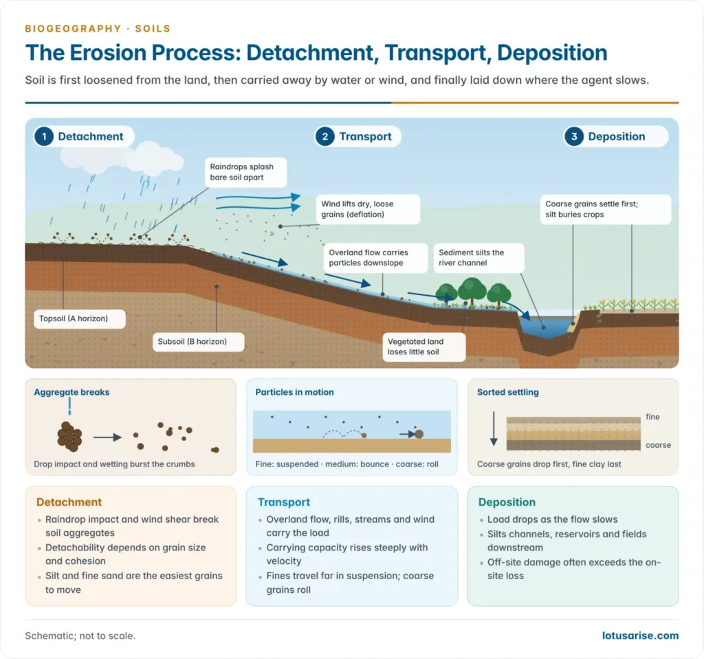
- Whatever the agent (water, wind, ice or gravity), soil erosion always works through two physical processes:
- Loosening and detachment of soil particles from the parent soil mass;
- Removal and transport of the detached particles downslope or downwind.
- When the agent loses energy, the load is laid down. Deposition is the third stage, and it creates the off-site damage of siltation.
- Detachability of particles is the crucial rate-limiting factor. As L. Donald Meyer and Walter H. Wischmeier (1969) showed in modelling erosion by water, it depends chiefly on grain size and cohesiveness.
- Particles coarser than about 0.2 mm need progressively greater flow velocity to move, because of their weight.
- Fine silt and clay are held by cohesion, so they too resist detachment; once loose, they travel far in suspension.
- Hence silt and fine sand are the most easily eroded grains, the pattern summed up in the curve of Filip Hjulström (1935).
- At the scale of a hillslope, Marie Morisawa (1968) identified two largely independent controls on the rate and type of erosion:
- Climate: rainfall intensity, seasonality and wind regime;
- Geology: rock type, structural weakness and slope material.
- These interact with land use to decide between gentle sheet wash and destructive gullying.
Factors that control the rate of erosion
| Factor | What raises erosion | What lowers it |
|---|---|---|
| Climate (erosivity) | Intense, concentrated rain; strong dry winds | Gentle, well-spread rain |
| Soil (erodibility) | Silty and fine sandy texture, weak structure, little organic matter | Stable aggregates, high organic matter, good infiltration |
| Topography | Steep and long slopes | Gentle, short slopes |
| Vegetation | Bare or sparse cover | Dense canopy, litter and roots |
| Land use | Up-and-down tillage, overgrazing, construction | Contour farming, terracing, cover crops |
- Soil properties decide erodibility. Texture, structure and organic matter set how readily aggregates break and how fast water infiltrates.
- Vegetation is the master control: canopy, litter and roots shield and bind the soil.
Measuring erosion: USLE and RUSLE
- The Universal Soil Loss Equation (USLE) of Walter H. Wischmeier and Dwight D. Smith (1965, revised 1978) predicts average annual sheet and rill erosion from a field:
- A = R × K × LS × C × P, where A is soil loss in tonnes per hectare per year.
- The Revised USLE (RUSLE) of Kenneth G. Renard and colleagues (1997) keeps the same factors with better data. Combined with satellite data and GIS, it now maps erosion over whole countries.
| Factor | Meaning | Example of its effect |
|---|---|---|
| R | Rainfall erosivity (energy × intensity of storms) | Monsoon downpours give very high R |
| K | Soil erodibility | Silty soils high, clayey and well-aggregated soils low |
| LS | Slope length and steepness | Doubling slope steepness much more than doubles loss |
| C | Cover and management | Forest near 0; bare fallow 1 |
| P | Support practice | Contouring, strip cropping, terracing below 1 |
- Soil loss tolerance (T value) is the maximum rate of loss that still sustains productivity, usually set between 2.5 and 12.5 t/ha/yr in India depending on soil depth. Erosion above T is accelerated erosion.
- For wind, the Wind Erosion Equation of N. P. Woodruff and F. H. Siddoway (1965) plays the same role.
- A national RUSLE mapping of India (2024) at 250 m resolution found about 30% of the country under minor erosion and about 3.2% under catastrophic erosion above 100 t/ha/yr.
- The Brahmaputra basin has the highest mean loss (about 48 t/ha/yr). Nine of the 20 most erosion-prone districts are in Assam.
- Rainfall erosivity was the most influential factor.
Water erosion
- Erosion is classified by its agent into water erosion and wind erosion.
- Running water is the principal agent. It acts through raindrops, overland flow, streams, waves and, in cold regions, ice.
- The intensity and nature of the process give rise to the following subtypes.
| Type | Mechanism | Key detail |
|---|---|---|
| Raindrop (splash) erosion | Raindrops strike bare soil like tiny bombs, splashing particles and breaking aggregates | A large drop of about 5 mm hits at about 9 m/s (32 km/h); vegetation intercepts drops before they reach the soil |
| Sheet (wash-off) erosion | A thin, uniform film of overland flow removes a layer of soil | Extremely slow; often unnoticed until fertility has fallen |
| Rill erosion | Finger-like channels form on cultivated land already suffering sheet erosion | Smoothed out by yearly tillage, but if unchecked they grow in number, width and depth every season |
| Gully erosion | Rills enlarge into gullies; deep gullies are called ravines | Gullies can reach about 30 m deep, ending normal farm operations |
| Tunnel (piping) erosion | Water moving below the surface scours pipes that later collapse into gullies | Common in dispersive, sodic and loess soils |
| Streambank erosion | Flowing water cuts the banks of streams and rivers | Can change the course of a river and damage roads along its banks |
| Landslide-driven erosion | Sudden mass movement when a slope loses balance under gravity | Inhibits farming and land use and can kill people and animals |
| Coastal erosion | Wave action and the landward advance of the sea | The adjoining land is often buried under sand |
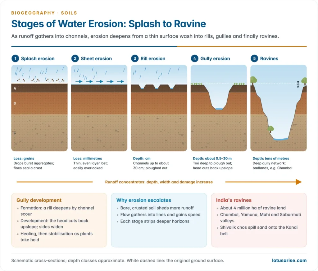
- Splash erosion also seals the surface: dislodged fine particles clog pores and form a crust, which cuts infiltration and raises runoff, so splash sets up the sheet wash that follows.
- Water erosion therefore progresses in stages: splash → sheet → rill → gully → ravine. The end stage, a maze of ravines, is called badland topography.
- A gully develops in four stages:
- Formation: a rill deepens by channel scour.
- Development: the gully head cuts back upslope and the channel widens; this is the most destructive stage.
- Healing: vegetation begins to colonise the floor and sides.
- Stabilisation: a stable gradient and plant cover; no further erosion.
- Indian examples:
- The Chambal, Yamuna, Mahi and Sabarmati ravines form part of India’s about 4 million ha of ravine land, across Uttar Pradesh, Madhya Pradesh, Rajasthan and Gujarat.
- The Shivalik hills of Punjab, Haryana and Himachal Pradesh are cut by chos, seasonal torrents that spread sand over the Kandi belt below.
- About a third of India’s coastline eroded between 1990 and 2018, most of all in West Bengal (60.5% of its coast), Puducherry, Kerala and Tamil Nadu.
Consequences of water erosion
- Erosion strips the most fertile part of the soil, the topsoil, and leaves the less fertile subsoil exposed.
- The fine particles of topsoil, which hold most of the nutrients and organic matter plants need, are lost first.
- It removes seeds and seedlings, leaving the soil bare. Bare soil is even more vulnerable to wind and water: a self-reinforcing cycle.
- Loss of cover and topsoil also cuts the soil’s ability to store water.
- Sheet, rill, gully and streambank erosion cause siltation of rivers, streams and fields downstream.
- Silt buries standing crops and pastures and causes sedimentation of streams, dams and reservoirs.
- Sedimentation degrades water quality and damages aquatic habitats and the organisms in them.
- Coastal erosion buries the adjoining land under sand.
Wind erosion
- Wind erosion is most common where natural vegetation has been destroyed: in arid and semi-arid regions and along the sandy shores of oceans, lakes and rivers, where little binds loose particles.
- It works in two ways:
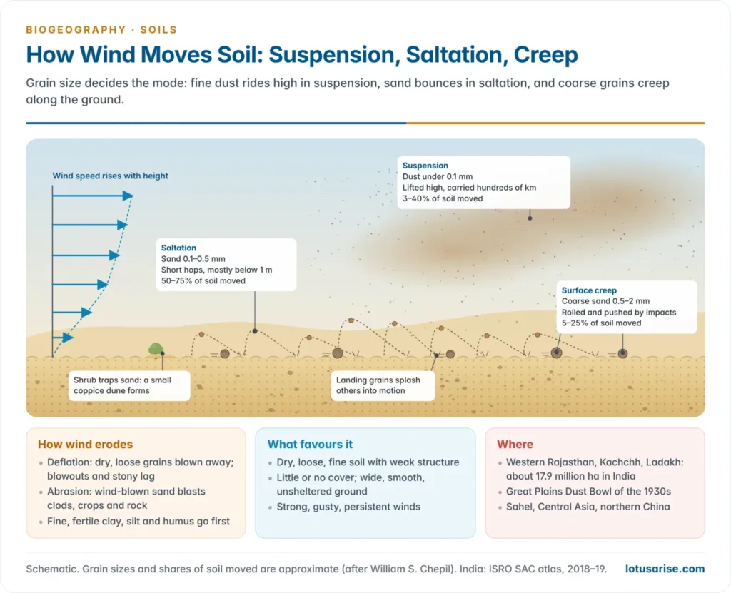
- Deflation: wind lifts and removes loose, dry particles, lowering the surface and leaving blowouts and stony lag. These are among the arid landforms wind creates.
- Abrasion: wind-blown grains sandblast soil clods, crops and rock.
- Conditions favouring it: dry, loose, fine soil with weak structure; little or no plant cover; a smooth, wide, unsheltered surface; and strong, gusty, persistent winds.
- William S. Chepil, the pioneer of wind-erosion research, showed that grains of about 0.1–0.5 mm move most readily. Wind moves soil in three modes:
| Mode | Grain size (approx.) | Share of soil moved (approx.) | Mechanism |
|---|---|---|---|
| Saltation | 0.1–0.5 mm | 50–75% | Grains lifted and dropped in short, repeated bounces close to the ground; each impact dislodges more grains |
| Suspension | Below 0.1 mm | 3–40% | The finest dust is carried high and over long distances, causing regional dust storms |
| Surface creep | 0.5–2 mm | 5–25% | Coarser grains rolled or pushed along the ground by strong winds and saltating grains, never fully airborne |
- The Dust Bowl of the 1930s on the North American Great Plains is the classic case. Ploughed-up prairie grassland blew away in drought years, and it led to the US Soil Conservation Service (1935) under Hugh Hammond Bennett.
- In India, wind erosion affects about 17.9 million ha, almost all in the arid north-west: western Rajasthan, Kachchh and the cold desert of Ladakh. Pre-monsoon dust storms carry Thar dust across the Indo-Gangetic Plain.
Consequences of wind erosion
- Wind selectively removes the finer soil material, the organic matter, clay and silt, in suspension, leaving coarser and far less fertile material behind.
- Most plant nutrients are held on the fine colloidal fraction, so the productive capacity of the soil is lost with it.
- Wind erosion damages roads and fertile fields directly by burying them under drifting sand, and sandblasting cuts young crops.
Causes and Consequences of Accelerated Erosion
- Four broad categories of human activity turn slow, geological erosion into the destructive, accelerated form: deforestation, farming practices, mining and economic extraction, and developmental construction.
Deforestation
- Deforestation includes the felling of trees, removal of forest litter, and browsing and trampling of vegetation by livestock; forest fires add to it.
- It leads directly to erosion and then to wider land degradation, nutrient loss and the breakdown of the soil–plant relationship that had held the ground.
- Clearing upper catchments turns rivers flashy and silt-laden. Deforestation of the Shivaliks produced the chos, and deforestation in the Himalaya adds to the sediment load of the Ganga and Brahmaputra systems.
Farming
- Agriculture is the single largest human cause of soil erosion. Crops are grown and harvested and the land is re-ploughed, leaving it intermittently exposed to wind and rain and preventing the replenishment of soil moisture. It causes the worst erosion on farmland, sheet (wash-off) erosion.
- In arid and semi-arid areas, sand blows and sand shifts act like sheet erosion with wind as the agent. The creeping effect of desertification sets in, and the land’s fertility is lost progressively.
Agricultural practices that accelerate erosion
- Tilling and ploughing disturb the natural surface and destroy protective cover.
- Continuous cropping of the same land, and extension of cultivation onto marginal and sub-marginal land, encourage erosion.
- Cultivation on mountain slopes without treatment such as bunding, terracing or trenching causes erosion and severe nutrient loss.
- Jhum (shifting) cultivation in the north-eastern hill states (Nagaland, Mizoram, Manipur, Meghalaya) is the Indian illustration. As population pressure shortens the fallow cycle from 20–30 years to a few years, sheet and gully erosion accelerate.
- Monoculture accelerates erosion in three ways:
- the whole field is harvested at once, leaving it bare;
- without standing vegetation, rain is not retained and runs off, carrying topsoil;
- a single disease or pest can wipe out the crop and expose the soil.
- Overgrazing keeps too many animals on a piece of grassland. Trampling and grazing destroy the vegetation, leaving land open to wind and water erosion and compacting the surface.
- It is widespread in the semi-arid tracts of western Rajasthan, where loss of grass cover speeds desertification, and is a leading cause of bioloss in rangelands worldwide.
Mining and economic activities
- Extracting metals, minerals and fossil fuels disturbs the land severely, leaving spoil heaps, open pits and bare overburden that erode rapidly and change the surrounding landscape.
- Jharkhand, with its coal and iron-ore belts on the Chotanagpur plateau, has the highest share of degraded land of any state (68.8%). Water erosion of its slopes and mined land is the main process.
Developmental work, settlements and transport
- Building houses, roads, railways, communication lines and recreational facilities disturbs the land massively, causes erosion and disrupts natural drainage.
- Hill roads cut without slope protection trigger landslides, as along Himalayan highways; such landslides strip soil from whole slopes.
Consequences of soil erosion
| On-site (where soil is lost) | Off-site (where sediment goes) |
|---|---|
| Loss of fine topsoil, nutrients and organic matter | Siltation of rivers, canals and fields |
| Loss of seeds and seedlings; bare, more erodible soil | Sedimentation of dams and reservoirs; lost storage and power |
| Lower water-holding capacity; more drought stress | Floods from silted channels; shifting river courses |
| Gullies and ravines that end cultivation | Eutrophication and damage to aquatic habitats |
| Shallower soils, lower yields, abandoned land | Sand burial of fields and roads by wind and coastal erosion |
- Scale in India: India loses an estimated 5.3 billion tonnes of soil a year, about 16.4 t/ha/yr.
- About 29% is carried to the sea and lost for ever, 10% settles in reservoirs and cuts their storage, and the rest is shifted from place to place on land.
“Creeping death”: why erosion is so dangerous
- It is slow and unseen. Sheet erosion removes a millimetre or two a year, invisible until yields fall and the paler subsoil shows through.
- It is practically irreversible. Topsoil that took centuries to form can go in a few storms on bare land.
- It is self-reinforcing. Thinner soil supports less cover, and less cover allows more erosion, until the land is abandoned as wasteland or badland.
Erosion, degradation and the food supply
- About 95% of our food comes from the soil, so erosion and degradation strike food security at its base.
- Lower yields: erosion can cut crop yields by up to 50% on badly eroded land and could reduce global yields by up to 10% by 2050.
- India: water erosion causes an annual loss of about 13.4 million tonnes of rainfed cereals, oilseeds and pulses, worth about ₹205 billion at 2011–12 support prices. About 126 million ha (39% of the country) loses more than 10 t/ha/yr.
- Shrinking and costlier inputs:
- Eroded and salinised land needs more fertiliser for the same yield.
- Silted reservoirs supply less irrigation water.
- Salt-affected land, about 10% of the world’s irrigated cropland, yields less.
- Wider stakes: land degradation costs about US$878 billion a year worldwide, and it pushes people from farming and fuels migration and conflict. These links make it central to food security and to SDG 2 (zero hunger) and SDG 15.3 (land degradation neutrality).
Land and Soil Degradation
Concept
- Land degradation is a decline in the productivity of land, in both biological and economic terms, caused by climatic and human factors, leading to loss of ecosystem functions.
- Soil degradation is the narrower decline in soil quality: its physical, chemical and biological health.
- Desertification is land degradation in arid, semi-arid and dry sub-humid areas resulting from various factors, including climatic variations and human activities (UNCCD, 1994).
- It is not the advance of deserts: it is the degradation of drylands, often in patches far from any desert.
- Degraded land is classified by the reduction in its productive capacity:
| Class | Reduction in crop yield potential |
|---|---|
| Slight degradation | Up to 10% |
| Moderate degradation | 10–50% |
| Severe degradation | More than 50% of the land’s potential yield capacity lost |
- Types of degradation:
| Type | Processes |
|---|---|
| Physical | Water and wind erosion, compaction, crusting and sealing, waterlogging |
| Chemical | Salinisation and alkalisation, acidification, nutrient depletion, pollution |
| Biological | Loss of organic matter and soil organisms, vegetation degradation |
- The global picture:
- The first world assessment, the Global Assessment of Human-induced Soil Degradation (GLASOD), led by L. Roel Oldeman (1991), mapped about 1,964 million ha of human-induced soil degradation.
- Of this, water erosion made up 56%, wind erosion 28%, chemical degradation 12% and physical degradation 4%.
- In 2015 the FAO judged 33% of the world’s soils moderately to highly degraded.
- If the 2015–2019 trend continues, 1.5 billion ha must be restored by 2030 to reach a land-degradation-neutral world.
Causes of land degradation
- GLASOD’s causes of human-induced degradation: overgrazing (35%), deforestation (30%), agricultural mismanagement (28%), over-exploitation of vegetation for fuelwood (7%) and industrial and urban activities (about 1%).
- Overgrazing dominates in Africa and Australia, deforestation in Asia and South America, and agricultural mismanagement in North America.
- At the farm level, three causes stand out in the green-revolution belts: agrochemicals (chemical fertilisers and pesticides), excessive irrigation, and the cultivation of high-yielding varieties (HYVs).

Agrochemicals and their harmful effects
- Agrochemicals are applied for two reasons: to replenish soil nutrients with chemical fertilisers, and to destroy pests with toxic chemicals called pesticides.
Adverse effects of chemical fertilisers
- Plants take up nutrients continuously, and repeated cropping depletes them; hence the periodic need for fertilisers. Excessive use, however, harms the land.
- Micronutrient depletion: most fertilisers supply only the macronutrients nitrogen, phosphorus and potassium (NPK).
- Heavy NPK doses push yields and so draw more micronutrients from the soil.
- Soils run short of zinc, iron, copper and boron, and productivity falls. Zinc deficiency is now widespread in Indian soils.
- Distorted NPK ratios: subsidised urea encourages nitrogen-heavy application, unbalancing the soil and acidifying it over time.
- Eutrophication: fertiliser not taken up by plants washes into water bodies, causing algal blooms that strip oxygen and kill aquatic life.
- Nitrate pollution:
- Often only a third to a half of the nitrogen applied to cereals is taken up by the crop. Much of the rest leaches into groundwater aquifers.
- Excess nitrate in drinking water causes methaemoglobinaemia (“blue baby syndrome”) in bottle-fed infants.
Adverse effects of plant protection chemicals (biocides)
- Toxic chemicals used to kill pests are collectively termed biocides: agents that kill organisms.
- Biocides are not selective. They kill non-target and useful organisms too: earthworms, pollinators and the natural enemies of pests.
- They stay chemically active long after killing their targets (pests, weeds, fungi or rodents). This persistence, with biomagnification up food chains, makes them harmful over the long term.
Problems due to excessive irrigation
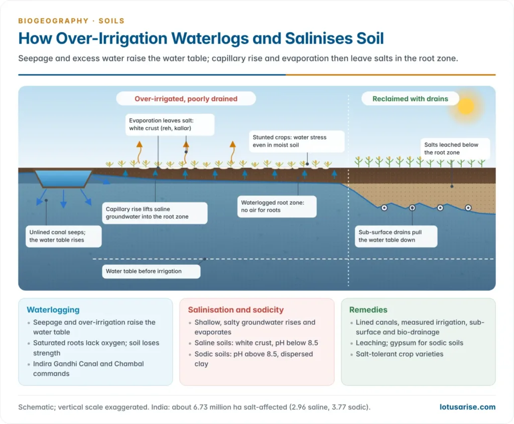
- Excessive irrigation leads to two linked degradation pathways: waterlogging and accumulation of salt.
- Waterlogging: irrigation without drainage, and seepage from unlined canals, raise the water table until the root zone is saturated.
- Waterlogged soil lacks air, especially the oxygen roots need to respire.
- It also lacks mechanical strength: it cannot hold plants upright, so they fall over and lodge in the mud.
- Salt affectation: in hot climates, irrigation water evaporates rapidly and leaves its dissolved salts behind.
- Where the water table is within about 2 m, capillary rise brings saline groundwater to the surface, where it evaporates.
- Over repeated cycles the salts build up into a thick white or grey efflorescence.
- Plants in saline soil cannot absorb water and nutrients properly and suffer physiological drought: water stress even when the soil is moist.
- Saline and sodic (alkali) soils differ in their salts and in how they are reclaimed. Salinisation and alkalisation as soil-forming processes also occur naturally in dry climates.
| Basis | Saline soil | Sodic (alkali) soil |
|---|---|---|
| Dominant salts | Chlorides and sulphates of sodium, calcium and magnesium | Sodium carbonate and bicarbonate; high exchangeable sodium |
| pH | Below 8.5 | Above 8.5, often 9–10.5 |
| Surface | White salt crust | Black, dispersed, hard surface (“black alkali”) |
| Structure | Usually good | Clay dispersed; very poor infiltration |
| Reclamation | Leaching with good water plus drainage | Gypsum to replace sodium, then leaching |
- Global extent: about 1,381 million ha (10.7% of the world’s land) is salt-affected. So is about 10% of both irrigated and rainfed cropland.
- India: about 6.73 million ha is salt-affected: 2.96 million ha saline and 3.77 million ha sodic.
- The worst-hit areas are Gujarat (mostly saline, coastal and the Rann), and Uttar Pradesh, Punjab and Haryana (mostly sodic usar and canal-command salinity).
- The area could reach 16.2 million ha by 2050 if poor drainage and saline groundwater use continue.
Impact of high-yielding varieties (HYVs)
- HYVs are man-made varieties of crops, fodder plants, forest trees, livestock and fish. They raised food production sharply, but with heavy environmental costs.
- They need assured irrigation and heavy doses of fertilisers and pesticides, so they indirectly drive both the agrochemical and the excessive-irrigation pathways above.
- The rice–wheat system of the green revolution belt, with residue burning, has depleted organic carbon, micronutrients and groundwater in Punjab and Haryana.
Other degradation processes
- Soil acidification:
- It comes from heavy rainfall leaching bases, acid-forming fertilisers, and acid rain near industrial areas.
- Below about pH 5.5, aluminium and manganese become toxic and phosphorus is fixed. About 17.9 million ha of India’s soils are acid-degraded, mainly in the north-east, the Western Ghats and the eastern plateau.
- Nutrient mining and loss of organic matter:
- Crops remove more nutrients than are returned, and residues are burnt instead of being returned.
- Most Indian soils are now low in organic carbon, which weakens structure and makes them more erodible.
- Compaction, crusting and sealing:
- Heavy machinery and trampling compact the subsoil.
- Urban growth seals the surface under concrete and asphalt, a permanent loss of soil.
- Soil pollution is the build-up of toxic substances to levels that harm organisms, crops and people.
- Sources: industrial effluents and sludge, mining waste, municipal solid waste, e-waste, pesticides, and sewage irrigation.
- Indian hotspots: the chromite belt of Sukinda (Odisha), with hexavalent chromium; the industrial corridors of Vapi and Ankleshwar (Gujarat) and Patancheru (Telangana); and peri-urban fields irrigated with sewage around large cities.
- Remedies: treatment at source, phytoremediation, bioremediation, liming of acid sites and safe disposal of waste.
- Mass movement and frost shattering degrade mountain land in the Himalaya. Vegetation degradation, the thinning of forest and scrub cover, is India’s second-largest degradation process.
Desertification
- Drylands are areas with an aridity index below 0.65. They cover about 41% of the world’s land and over two-thirds of India.
- Causes:
- Climatic: droughts, rainfall variability and rising temperatures.
- Human: overgrazing, over-cultivation of marginal land, cutting of woody vegetation for fuel, faulty irrigation, and excessive groundwater pumping.
- Processes: wind erosion and sand encroachment in arid areas; water erosion and vegetation degradation in semi-arid and dry sub-humid areas; and salinisation in irrigated drylands.
- Desiccation and soil loss:
- Removal of cover exposes the soil to sun and wind, so it dries out. Organic matter and soil life decline, aggregates collapse, and the loose, dry surface is blown or washed away.
- Higher surface albedo and lower evapotranspiration can further reduce local rainfall, a feedback first argued by Jule Charney (1975) for the Sahel.
- India: about 83.7 million ha of drylands were undergoing desertification in 2018–19.
- Wind erosion dominates the arid zone of Rajasthan, Gujarat and Ladakh.
- Water erosion dominates the semi-arid Deccan, as in Maharashtra, Karnataka and Telangana.
- Drought years accelerate both.
Soil Conservation and Land Restoration
Principles of soil conservation
- Retain vegetation cover so the soil is not exposed to rain. Roots hold particles together, and plants intercept rainfall and break the impact of raindrops.
- Control cattle grazing to protect the vegetative cover.
- Adopt crop rotation and keep land fallow at times, so the soil recovers structurally and biologically.
- Improve vegetation and soil management to raise soil organic matter.
- Against streambank erosion, store runoff in the catchment as long as possible: maintain vegetation cover and build dams for water storage.
- Against coastal erosion:
- Re-establish protective beach vegetation.
- The best way to control dune erosion is not to disturb the dunes and the coastal system at all.
- Site buildings and other development behind the dune system.
- Against wind erosion:
- Keep vegetation cover on sandy soils above 30%.
- Control the wind’s access to bare soil by leaving stubble (the remains of a crop after harvest) or mulch on the surface.
- Break wind speed with trees planted as a shelter belt.
- Treat land according to its capability: steep, shallow land goes to forest or grass, not to the plough.
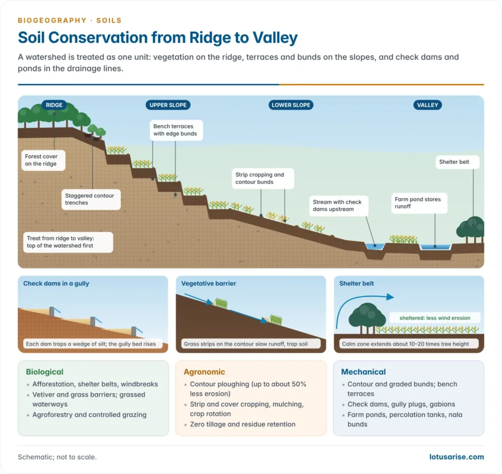
- Treat a watershed as a whole, from ridge to valley.
Biological measures: trees and vegetation
- Trees break the force of the wind and shield the soil from sun, rain and wind. Their roots hold soil particles together, anchoring them against detachment.
- Shelter belts and windbreaks: rows of trees and shrubs at right angles to the prevailing wind cut wind speed for a distance of about 10–20 times their height downwind.
- The arid-zone research centre at Jodhpur has stabilised shifting dunes in western Rajasthan with shelter belts, micro-windbreaks and grass and shrub planting.
- Afforestation of degraded slopes and catchments, and vegetating gullies.
- Vegetative barriers: strips of dense grass such as vetiver along the contour slow runoff and trap sediment.
- Grassed waterways carry runoff safely off fields without scouring.
- Agroforestry and social forestry combine trees with crops and pasture on farmland and commons. Agroforestry keeps the soil covered and returns litter to it.
Cultivation and farming techniques
| Technique | Mechanism | Note |
|---|---|---|
| Cultivation direction | Ploughing at right angles to the wind direction | Simple, needs no structures |
| Contour ploughing | Tilling across the slope instead of up and down it; ridges act as tiny dams that hold water and let it soak in | Can reduce erosion by up to 50% |
| Strip farming (strip cropping) | Widely spaced rows of the main crop, with the spaces filled by another crop for full cover | Slows runoff and lets water infiltrate |
| Terracing | Levelling steps on steep slopes so water cannot run straight down | Terraces can themselves erode and need maintenance |
| Timing of tillage | Ploughing in autumn leaves soil bare all winter; retaining cover until spring sowing, or until the rains in the tropics, shortens exposure | Low-cost scheduling change |
| No-till (zero-till) cultivation | Machines loosen soil, plant seed and control weeds with minimum disturbance | Weeds and insects may increase because they are no longer disturbed |
| Polyvarietal cultivation | Several varieties of one crop that mature at different times | The field is never bare all at once |
| Addition of organic matter | Ploughing in crop residues or green manure crops | Microbes produce sticky polysaccharides that glue soil particles |
| Mulching | Covering soil with straw, residues or plastic | Absorbs raindrop impact and cuts evaporation |
| Cover and mixed cropping | Close-growing crops or intercrops between main crops | Keep the ground covered through the rains |
- Conservation agriculture combines minimum tillage, permanent residue cover and crop rotation.
- Zero-till wheat after rice, with the Happy Seeder sowing into standing stubble, spread across the Indo-Gangetic Plain. It saves soil, water and fuel and cuts stubble burning.
Mechanical (engineering) measures
- Contour bunds: earthen embankments along the contour on gentle slopes in low-rainfall areas, holding water in place.
- Graded bunds: bunds with a slight gradient that lead excess runoff safely away in high-rainfall areas.
- Bench terraces: level or inward-sloping steps on slopes of about 16–33%; the classic hill-farming measure.
- Trenches and pits: staggered contour trenches on degraded hills for afforestation and recharge.
- Gully control: brushwood and loose-stone check dams, gabions (wire-mesh boxes of stones) and drop structures across gullies, plus a peripheral bund to stop the gully head advancing.
- Water harvesting structures: farm ponds, percolation tanks and nala bunds store runoff and recharge groundwater.
- Ravine reclamation: levelling shallow ravines for farming and planting trees and grass in deep ravines, as in the Chambal valley.
Agricultural technologies against soil degradation
- Organic farming and green manures:
- Instead of chemical nitrogen, harness biological nitrogen fixation by bacteria in the root nodules of legumes.
- Add organic fertilisers such as cow dung, compost and farm waste. These cut the excessive and prolonged use of chemical fertilisers and their toxic side-effects.
- India’s National Mission on Natural Farming (November 2024), with an outlay of ₹2,481 crore, aims to bring 7.5 lakh ha and 1 crore farmers under chemical-free natural farming.
- Biofertilisers:
- Micro-organisms are essential to fertile soils. They build soil structure, add available nutrients and improve physical condition.
- Rhizobium, Azotobacter, Azospirillum, blue-green algae, phosphate-solubilising bacteria and mycorrhizae are used to improve crop nutrition.
- Biological pest control:
- Natural predators and parasites of pests and pathogens control them without poisons.
- They do not enter the food chain or poison other animals, so they are unlikely to harm people, unlike persistent biocides.
- Integrated pest management (IPM) combines them with resistant varieties and minimal, targeted spraying.
- Balanced fertilisation: apply nutrients on soil-test values. The Soil Health Card scheme (2015) gives farmers plot-wise recommendations, including micronutrients.
- Reclaiming problem soils:
- Sodic soils: gypsum, organic matter and salt-tolerant varieties bred at the Central Soil Salinity Research Institute, Karnal.
- Waterlogged saline soils: sub-surface drainage and bio-drainage with trees such as eucalyptus.
- Acid soils: liming.
- Ravines and mined land: levelling, topsoil replacement and afforestation.
Watershed management
- A watershed is the area draining to a common outlet. Treating it from ridge to valley links soil conservation, water harvesting, afforestation and livelihoods in one plan.
- Sequence: treat the upper catchment first (forest, trenches), then the arable slopes (bunds, terraces), then the drainage lines (check dams, ponds), so that structures below are not silted by erosion above.
- Indian successes:
- Sukhomajri (Haryana), in the Shivalik foothills, began in the late 1970s. Small earthen dams and community control of grazing cut the silting of Chandigarh’s Sukhna Lake and raised crop and grass yields.
- Ralegan Siddhi and Hiware Bazar (Maharashtra) turned drought-prone villages green through community watershed management, grazing and felling bans, and water budgeting.
- Hill areas need watershed treatment most:
- Steep slopes, intense monsoon rain, fragile rocks and shallow soils combine with jhum, road cutting and deforestation.
- Bench terracing, contour trenching, spring-shed management and catchment afforestation are the core measures.
Indian Context
Extent of land degradation in India
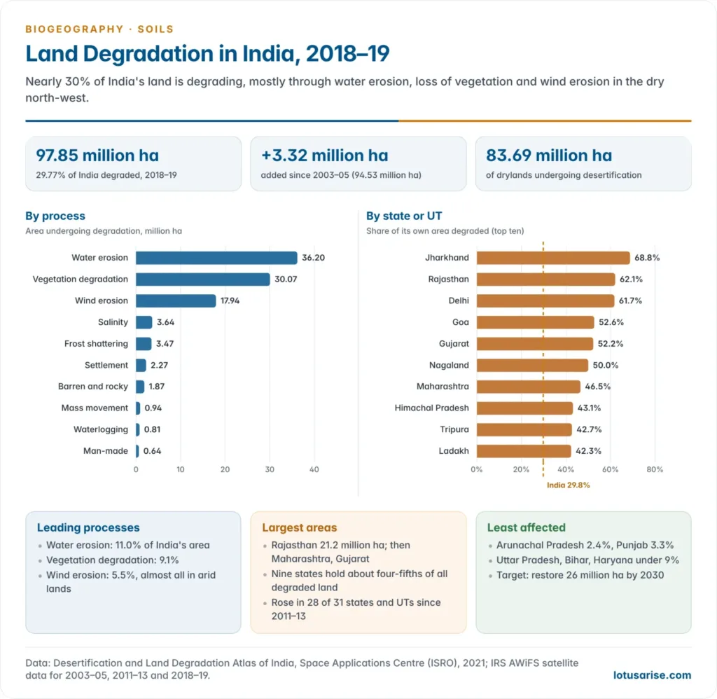
- The Desertification and Land Degradation Atlas of India (Space Applications Centre, ISRO, June 2021) is the latest national assessment. It maps the 2018–19 status from IRS AWiFS satellite data and compares it with 2003–05 and 2011–13.
- 97.85 million ha, 29.77% of India’s area, was undergoing land degradation in 2018–19, up from 94.53 million ha (28.76%) in 2003–05 and 96.40 million ha (29.32%) in 2011–13.
- Degradation rose in 28 of 31 states and UTs between 2011–13 and 2018–19.
- Within drylands, 83.69 million ha was undergoing desertification.
| Process (2018–19) | Area (million ha) | Share of India’s area |
|---|---|---|
| Water erosion | 36.20 | 11.01% |
| Vegetation degradation | 30.07 | 9.15% |
| Wind erosion | 17.94 | 5.46% |
| Salinity | 3.64 | 1.11% |
| Frost shattering | 3.47 | 1.05% |
| Settlement | 2.27 | 0.69% |
| Barren and rocky land | 1.87 | 0.57% |
| Mass movement | 0.94 | 0.29% |
| Waterlogging | 0.81 | 0.25% |
| Man-made (mining and others) | 0.64 | 0.19% |
| Total | 97.85 | 29.77% |
- By area, Rajasthan (21.2 million ha), Maharashtra, Gujarat, Ladakh, Karnataka, Jharkhand, Odisha, Madhya Pradesh and Telangana hold degraded land equal to about 24% of India’s area: roughly four-fifths of all degraded land.
- By share of their own area, Jharkhand (68.8%), Rajasthan (62.1%), Delhi (61.7%), Goa (52.6%) and Gujarat (52.2%) have more than half their land degraded.
- Arunachal Pradesh (2.4%) and Punjab (3.3%) have the least; Uttar Pradesh, Bihar, Haryana, Assam and Kerala have under 11%.
- The Land Degradation Vulnerability Assessment (SAC, November 2024) goes further, rating vulnerability from climate, soil, terrain and population data in 30 pilot districts.
- Dryland districts are the most at risk: about 95% of Kachchh and 84% of Pali fall in the high and moderate classes.
- Other estimates: an ICAR assessment (2010) put degraded and wasteland at about 120.4 million ha.
- Water and wind erosion accounted for 94.9 million ha, soil acidity 17.9, sodicity 3.7, salinity 2.7, waterlogging 0.9 and mining and industrial waste 0.3 million ha.
- Estimates differ because of differences in method, scale and definition.
Regional problems
- North-east hills: jhum on steep slopes; acid soils; very high erosion in the Brahmaputra valley and the Meghalaya plateau.
- Himalaya:
- Deforestation, road cutting, landslides and frost shattering; heavy sediment loads in the Ganga and Brahmaputra.
- Seasonal chos in the Shivalik foothills.
- Western Rajasthan and Kachchh: overgrazing-driven wind erosion and sand drift on the margins of the Thar; desertification.
- Canal commands of Punjab, Haryana and western Uttar Pradesh: salinisation and waterlogging produce the reh, kallar and usar lands. Waterlogging and salinity also affect parts of the Indira Gandhi Canal command in Rajasthan.
- Chambal, Yamuna and Mahi valleys: gully and ravine erosion; the Chambal ravines are the classic case of gullying advancing into farmland.
- Chotanagpur plateau (Jharkhand, Odisha, Chhattisgarh): mining and water erosion of lateritic uplands.
- Coasts: erosion of about a third of the shoreline; cyclone and storm-surge damage.
- Traditional responses: bench terraces in the Himalayan foothills and the Western Ghats, the zabo system of Nagaland and the khadin run-off farming of the Thar are long-standing indigenous answers to slope and dryland erosion.
Institutional response
| Period | Programme or institution | Focus |
|---|---|---|
| 1953–1974 | Central Soil Conservation Board (1953); soil conservation research centres (1954); Central Arid Zone Research Institute, Jodhpur (1959) | Research and demonstration; dune stabilisation |
| 1970s | Drought Prone Areas Programme (1973–74); Desert Development Programme (1977–78) | Drought-prone and desert districts |
| 1989–1991 | Integrated Wastelands Development Programme (1989); National Watershed Development Project for Rainfed Areas (1990–91) | Watershed-based treatment |
| 2009–2015 | Integrated Watershed Management Programme (2009–10), merged into PMKSY as its watershed component (2015–16) | Ridge-to-valley watershed projects |
| 2008–2015 | National Action Plan on Climate Change (2008); its National Mission for Sustainable Agriculture (2014–15); Soil Health Card (2015) | Soil health, rainfed area development |
| 2021–2026 | Watershed Development Component of PMKSY 2.0 | ₹8,134 crore for about 49.5 lakh ha |
| 2025 | Aravalli Green Wall Project (launched 5 June 2025) | 5-km green belt around the Aravalli range in Gujarat, Rajasthan, Haryana and Delhi (29 districts) |
- The ICAR-Indian Institute of Soil and Water Conservation, Dehradun, and the Central Soil Salinity Research Institute, Karnal, lead research on erosion control and problem soils.
- Land degradation neutrality: at the UNCCD COP14 in New Delhi (September 2019) India raised its pledge to restore 26 million ha of degraded land by 2030.
- Global frameworks:
- UNCCD (1994), with its COPs: COP16 in Riyadh (December 2024) and COP17 in Ulaanbaatar (August 2026). COP17 launched a US$1.2 billion Rangelands Flagship Initiative in the International Year of Rangelands and Pastoralists.
- SDG target 15.3 on land degradation neutrality, the Bonn Challenge and the UN Decade on Ecosystem Restoration (2021–2030).
- Gaps: poor upkeep of structures after projects end, weak community participation, subsidy-driven fertiliser imbalance and little drainage in canal commands.
Previous Year Questions
2026Deforestation in the upper reaches of a river augments the magnitude of soil erosion. Elaborate your answer citing the example of any North Indian river.2026Soil and water conservation are the major challenges in the development of hill areas of India. Explain.2024“Soil erosion is creeping death.” Explaining the statement, suggest various soil conservation measures.2022The process of desertification leads to soil desiccation and soil loss. Explain.2021Soil erosion and soil degradation are threats to the food supply. Discuss.2021Discuss the role of watershed management for soil and water conservation in hilly regions of India.2017What do you understand by soil pollution? Delineate the areas vulnerable to it in India and suggest remedial measures.2005Short note: Soil erosion and conservation.





Sir plz quickly upload rest topics of optional
Ok, Rabindra
sir, your notes are very helpful.
Thanks, Keep reading
Your notes are so helpful to us, who can’t afford to go coaching. Thanks a lot for your condition less support.
Got a foundation for your notes
This is so helpful thank u so much lotusarise 🙏🏻
Sir you’re doing great job for us, we’re highly indebted to your efforts ❤️🙏👏🙌
I’ve a request, can you please add some India related examples in Paper 1 notes (wherever possible) as it helps in linking our answers with Paper 2
thank you sir.