

Introduction: Why Hill Areas Need Special Planning

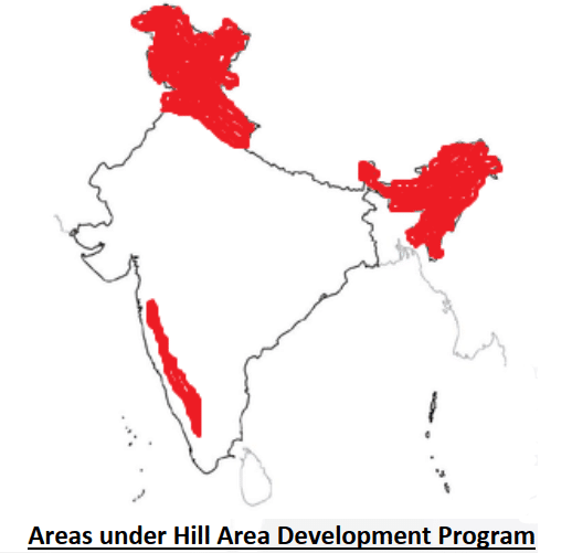
Hill area constitutes 18% of the total area of India where approximately 70 million of the total population dwells. The areas identified under HADP (Special Category States + designated hill areas) account for 22% of total geographical area of India where only 10% of Indian population dwells — reflecting sparse population density, inaccessibility, and historically low development investment.
India’s hill areas span a vast arc from the Himalayas in the north to the Western Ghats and Eastern Ghats in the peninsula, covering states and regions with enormous ecological, cultural, and economic diversity. Despite their richness in natural resources — water, biodiversity, minerals, and scenic landscapes — hill areas consistently lag behind the plains in most development indicators.
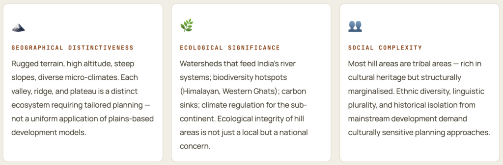
“Development should respect geography” — the philosophy that drives HADP. What works in the Indo-Gangetic Plain (irrigation-intensive Green Revolution agriculture, large factories) does not work on steep slopes with thin soils, poor connectivity, and fragile ecosystems. Hill area development requires a fundamentally different planning framework built around the area’s own ecological and cultural potential.
Characteristics of Hill Areas — Why They Are Structurally Disadvantaged
- Hilly areas are characterized by poor accessibility and difficult terrain. Soils on the slopes are thin, less productive, and prone to soil erosion. The overall milieu comprising topography, climate, culture, and economy is different from plains — thus a different planning approach is required for hilly areas.
- ⛰️ Physiographic Constraints
- Rugged terrain limits connectivity and infrastructure construction. Slope gradient constrains land use — cultivation confined to terraces; grazing limited to alpine meadows. Natural hazards (landslides, avalanches, earthquakes, cloudbursts) are endemic. Thin, less productive, erosion-prone soils.
- 🌧️ Climatic Extremes
- High precipitation on windward slopes vs. rain-shadow aridity on leeward sides. Harsh winters make many areas inaccessible for months. Climate change is accelerating glacial retreat, increasing cloudbursts, and changing snowfall patterns — disrupting traditional water availability.
- 🚫 Accessibility Deficit
- Road and rail construction is technically difficult and enormously expensive per km in mountains. Many hill communities remain connected only by seasonal roads or footpaths. This isolation raises the cost of all services — inputs, healthcare, education, market access.
- 🌲 Ecological Fragility
- Mountain ecosystems are fragile and slow to recover from disturbance. Deforestation triggers soil erosion and landslides. The ideal: 60% of the geographical area of mountainous states should be forested to maintain ecological stability and watershed functions.
- 💰 High Development Cost
- The development of mountainous regions depends on four high-expenditure requirements: transport network, land development, afforestation, and energy. Each costs multiple times more per beneficiary than in plains regions — requiring special central assistance.
- 🧑🌾 Outmigration
- Limited livelihood options and high infrastructure costs drive the outmigration of working-age population — especially men — to plains. Villages become feminised, ageing, and further depopulated. Development is thus both a consequence of outmigration and a precondition for reversing it.
| Dimension | Plains | Hill Areas | Planning Implication |
|---|---|---|---|
| Terrain | Flat, uniform | Rugged, variable, slope-dominant | Infrastructure 3-5× more costly per km; land use planning essential |
| Soil | Deep, alluvial, fertile | Thin, rocky, erosion-prone | Terracing, afforestation, soil conservation mandatory |
| Climate | Predictable, agricultural | Altitudinal variation, extreme seasons | Zone-specific crop planning; climate adaptation critical |
| Connectivity | Dense road/rail network | Sparse, seasonal roads; no rail in many areas | Connectivity is prerequisite for all other development |
| Economy | Commercial agriculture, industry | Subsistence agriculture, forest products, tourism | Horticulture, eco-tourism, small industries as development base |
| Population | Dense, urbanising | Sparse, rural, outmigrating | Community-based development; women’s participation essential |
| Governance | Well-staffed administration | Under-staffed, poorly connected administration | Decentralised Panchayati Raj; community self-governance |
Planning Philosophy for Hill Areas
The unique character of hill areas demands a distinctive planning philosophy — one that integrates economic development with ecological conservation, and that recognizes the hill communities as both the beneficiaries and custodians of development.
Four Pillars of Hill Area Development
- The development of mountainous regions depends upon the development of four things — all requiring high expenditure:
- (1) Transport network,
- (2) Land development,
- (3) Afforestation, and
- (4) Energy.
- Planning should be directed towards building physical infrastructure while emphasizing environmental considerations — ensuring that the externalities of development do not take a toll on the natural and cultural setting of hill areas.
- 🛣️ Transport Network
- Roads, railways, ropeways, helipads. Connectivity is the master multiplier — without it, no other investment reaches its intended beneficiaries. High priority and high cost.
- 🌾 Land Development
- Terracing, bunding, check dams, soil conservation — converting fragile slopes into productive, stable agricultural or horticultural land. Prerequisite for food security and livelihood.
- 🌳 Afforestation
- Restoring and maintaining forest cover to 60% of hill area — protecting watershed functions, preventing landslides, maintaining biodiversity, and supporting community forest-based livelihoods.
- ⚡ Energy
- Hydro-power potential is enormous in hill areas — but electricity from hydro projects must benefit local hill communities, not just distant plains consumers. Solar mini-grids for remote villages.
The Special Planning Requirement
- Most of the hill areas are tribal areas — they are also getting the benefit of the Tribal Area Sub-Plan. Apart from this, all the rural development schemes are also being implemented in hill areas. But these general programmes are insufficient — the Hill Area Development Programme (HADP) provides the additional, area-specific planning framework that accounts for the unique physiographic, ecological, and cultural milieu of hill areas.
Hill Area Development Programme (HADP)
- The Hill Area Development Programme (HADP) was launched during the Fifth Five Year Plan (1974-79) as an area-based planning initiative. DDP, CADP, and TADP were also launched during the same plan. It was based on the modified Gadgil formula for central assistance to states. HADP was the first identified among all area development programmes in India — reflecting the early recognition of hill areas as uniquely disadvantaged backward regions.
- The National Committee on the Development of Backward Areas (1981) recommended that all hill areas in the country with elevations above 600 metres, and not covered under the Tribal Sub-Plan, should be treated as Backward Hill Areas.
Original 15 Districts under HADP
| State (at time of launch) | Districts Covered | Current State | Key Characteristic |
|---|---|---|---|
| Uttar Pradesh (UP) — Hill Districts | Dehradun, Pauri Garhwal, Tehri Garhwal, Chamoli, Uttarkashi, Nainital, Almora, Pithoragarh (8 districts) | Uttarakhand (bifurcated 2000) | Himalayan watershed; Char Dham; apple horticulture; tourism |
| Assam — Hill Districts | Mikir Hill (Karbi Anglong) and North Cachar Hills (2 districts) | Assam | Dense forest; Karbi and Dimasa tribal communities; tea |
| West Bengal | Darjeeling district (major part) | West Bengal | Darjeeling tea; tourism; Gorkha cultural region |
| Tamil Nadu | Nilgiri district | Tamil Nadu | Nilgiri biosphere reserve; tea, coffee; tribal communities |
Extended Coverage — 163 Talukas of Western Ghats
- In addition to the original 15 districts, HADP covers 163 talukas of the Western Ghats area: Maharashtra (62 talukas), Karnataka (40 talukas), Tamil Nadu (29 talukas), Kerala (29 talukas), and Goa (3 talukas).
- This extension recognizes the Western Ghats as one of the world’s biodiversity hotspots — requiring special area-specific planning to balance conservation with development for the communities living in and around the Ghats.
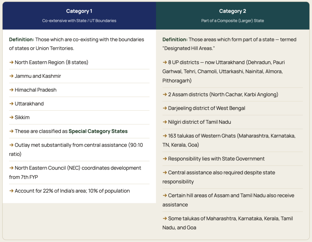
Two Categories of Hill Areas Under HADP
HADP divides India’s hill areas into two distinct administrative categories, each with different governance arrangements and funding patterns:
Objectives of Hill Area Development Programme
- HADP focuses on people’s participation — especially women — with the following three ecological objectives:
- (1) Eco-restoration — restoring degraded hill ecosystems;
- (2) Eco-development — developing the economy in harmony with ecology;
- (3) Eco-preservation — protecting intact ecosystems from degradation.
- The programme also focused on socio-economic development of tribal communities along with conservation of soil and water resources. Development of land use plans for both forest and cultivated areas was a key focus.
Complete List of HADP Objectives
- Harness indigenous resources: Exploit the hill area’s unique natural potential — horticulture, animal husbandry, forestry, plantation agriculture — through appropriate technology and market linkages
- Socio-economic development of tribal communities: Address the specific deprivation of hill-dwelling tribal populations through targeted programmes; HADP complements the Tribal Sub-Plan
- Conservation of soil and water resources: Watershed management, soil conservation, afforestation, and water harvesting to maintain the hill ecosystem’s productive capacity
- Land use plan development: Scientific land use planning for both forest areas (what to protect, what to manage sustainably) and cultivated areas (terracing, cropping pattern, soil conservation)
- People’s participation, especially women: Women are the primary land managers in hill areas (due to male outmigration); their participation in planning is not just equity — it is effectiveness
- Infrastructure development: Roads, energy, communication, schools, health centres — the physical prerequisites for any other development
- Eco-restoration, eco-development, eco-preservation: The three-phrase ecological philosophy of the 7th Plan (see Section 8)
Basic Objective (Planning Commission Statement)
“The basic objective of the Hill Areas Development Programme has been socio-economic development of the hills and the people living there in harmony with ecological development. The programmes implemented under the HADP have, therefore, aimed at promoting the basic life support systems with sustainable use of the natural resources of these areas.” — Planning Commission of India, HADP Document
Components and Sectoral Focus of HADP
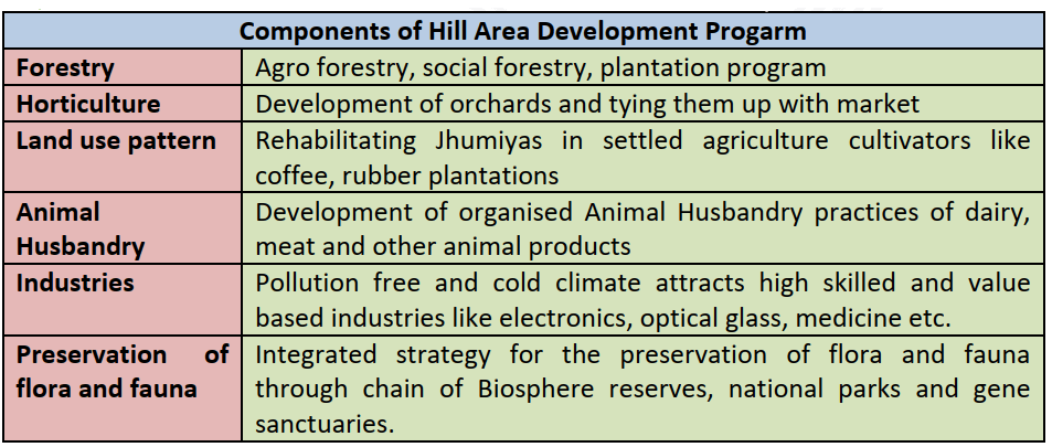
The detailed plans for the development of hill areas were drawn keeping in view their topographical, ecological, social, and economic conditions. HADP’s sectoral focus is specifically designed to match the hill area’s ecological potential:
| Sector | Activities | Rationale | Regional Example |
|---|---|---|---|
| Horticulture | Fruits (apple, kiwi, pear, walnut, cherry), vegetables (temperate), medicinal and aromatic plants, floriculture | Temperate slopes unsuitable for food grains are ideal for high-value horticultural crops; better income per unit area than cereals | Uttarakhand apple (Pauri, Uttarkashi); Himachal Pradesh apple; Nilgiri vegetables; Darjeeling horticultural crops |
| Plantation Agriculture | Tea, coffee, cardamom, rubber (at lower altitudes) | High-rainfall Western Ghats and Darjeeling-Nilgiri slopes are globally unique environments for quality tea production | Darjeeling tea; Nilgiri tea and coffee; Munnar (Western Ghats) cardamom |
| Animal Husbandry | Cattle, yak, sheep, goat rearing; dairy development; wool production | Alpine and sub-alpine meadows support pastoral economies; dairy provides regular income to marginal farming families | Uttarakhand dairy (cooperatives); Himachal Pradesh sheep and wool; NE India mithun (gayal) |
| Poultry | Local and improved breeds; egg and meat production | Low capital requirement; rapid income generation; fits into subsistence household economy; women-operated | NE India backyard poultry; Nilgiri hills turkey and quail |
| Forestry | Social forestry, farm forestry, joint forest management (JFM), NTFP (non-timber forest products) | Forests are the primary ecological and livelihood resource; sustainable forest management reconciles conservation with community income | JFM programmes in Uttarakhand and HP; NE India community forest management; Western Ghats NTFP collection |
| Small-Scale and Village Industry | Handicrafts, handloom weaving, sericulture, agro-processing, tourism-based enterprises, bamboo and cane products | Local raw materials + traditional skills + proximity to tourist markets = viable local enterprise; reduces need to migrate for income | Darjeeling handicrafts; Manipur handloom; Nagaland bamboo crafts; Uttarakhand agro-processing |
| Afforestation | Plantation by Panchayats, schools, local organisations; private nurseries of multipurpose trees | Ecological necessity for slope stability and water conservation; community-based afforestation more sustainable than departmental plantation | Van Panchayat system (Uttarakhand); NE India community forests; Western Ghats agroforestry |
| Watershed Management | Watershed-based land and water conservation; ISRO remote sensing for boundary delineation | Watershed is the natural planning unit for hill areas; ridge-to-valley treatment ensures upstream-downstream linkages; Nilgiri adopted watershed-based plan | Nilgiri Bhavani-Moyar-Kabini watershed plan; Uttarakhand microwatershed development |
The Eco-Triad: Eco-Restoration, Eco-Development, Eco-Preservation
- The Seventh Five-Year Plan laid particular emphasis on the development of ecology and environment in hill areas, summarised in three interconnected ecological principles — the Eco-Triad. These three concepts guide both the philosophy and the specific interventions of HADP:
- 🌱 Eco-Restoration
- Restoring degraded hill ecosystems to functional stability. Activities: afforestation of denuded slopes, reclamation of eroded gullies, restoration of degraded wetlands and springs (jal sanrakshan), rehabilitation of overused grazing lands, soil conservation engineering.
- Target: Restore 60% forest cover in hill states; recover degraded alpine meadows; stabilise landslide-prone slopes.
- ⚙️ Eco-Development
- Economic development in harmony with ecological capacity. Not zero development — but development designed to work with the ecosystem, not against it. Horticulture instead of rice on steep slopes; eco-tourism instead of mass tourism; sustainable NTFP harvesting instead of clear-felling.
- Target: Raise incomes while maintaining ecological services; sustainable livelihoods as both economic and environmental strategy.
- 🛡️ Eco-Preservation
- Protecting intact hill ecosystems from anthropogenic degradation. Protected areas (biosphere reserves, national parks, wildlife sanctuaries); buffer zones around sensitive habitats; regulation of construction in ecologically sensitive zones; prevention of mining in fragile ridges and watersheds.
- Target: Maintain biodiversity; preserve cultural landscapes; ensure ecological services continue for future generations.
- 🌱 Eco-Restoration
Evolution of HADP’s Approach Across Plans
| Plan Period | HADP Approach | Emphasis |
|---|---|---|
| 5th FYP (1974-79) | Largely beneficiary-oriented | Direct asset transfer and income generation for individuals in hill areas |
| 6th FYP (1980-85) | Shift to eco-development; similar sectoral approach to state plans | Ecology integrated with development; but still following general sectoral approach |
| 7th FYP (1985-90) | Eco-restoration, eco-preservation, eco-development — the Eco-Triad | Explicit ecological philosophy; evolution of integrated plans for socio-economic + ecological conservation |
| 8th FYP (1992-97) | Special programme for infrastructure in hill areas | Infrastructure as the binding constraint; connectivity and energy pushed to foreground |
| 9th FYP (1997-2002) | Allocations increased to ₹5,400 crore; community involvement | Larger resource allocation; local community participation as implementation strategy |
| Recent Plans (10th+ and NITI) | Stronger emphasis on local community involvement, modernisation of agriculture, small-scale industries | Sustainable development; SDG alignment; climate adaptation for hill areas |
Gadgil Formula and Financial Architecture
As per the Gadgil Formula, special central assistance needs to be given to certain areas which require more financial support due to their backward situation. The financial assistance constitutes 90% assistance by Central Government and 10% by State Government — a significantly more favourable ratio than the 60:40 arrangement for general states. This 90:10 ratio recognizes that hill states have limited own-revenue capacity and high per-capita development costs.
Areas Identified Under Gadgil Formula for Hill Area Special Assistance
- The following areas have been identified for special central assistance:
- 🏔️ Full Hill States (Special Category)
- Sikkim, Arunachal Pradesh, Nagaland, Manipur, Mizoram, Meghalaya, Tripura (NE states) + Jammu and Kashmir, Himachal Pradesh, Uttarakhand. These states qualify for 90:10 funding for all central plan schemes.
- 🌿 Hill Districts Within States
- Certain hill areas of Assam (Karbi Anglong, North Cachar) and Tamil Nadu (Nilgiri). Some talukas of Maharashtra, Karnataka, Kerala, Tamil Nadu, and Goa (Western Ghats). These receive special assistance despite being within general category states.
- 🏔️ Full Hill States (Special Category)
- North Eastern India — Special Focus: North-Eastern India is more focused under HADP. Since the 7th Plan, special allocation is made in the name of the North Eastern Council (NEC). The NEC was formed in 1971 as a statutory advisory body for coordinated economic and social development of the North-East. From the 7th Plan onwards, a dedicated North-East allocation ensures that the region’s development is not crowded out by competing demands from other backward regions.
Budget Evolution — Dramatic Growth in Allocation
- HADP allocations have drastically increased from the 5th Plan to the 9th Plan, reflecting growing policy commitment to hill area development:
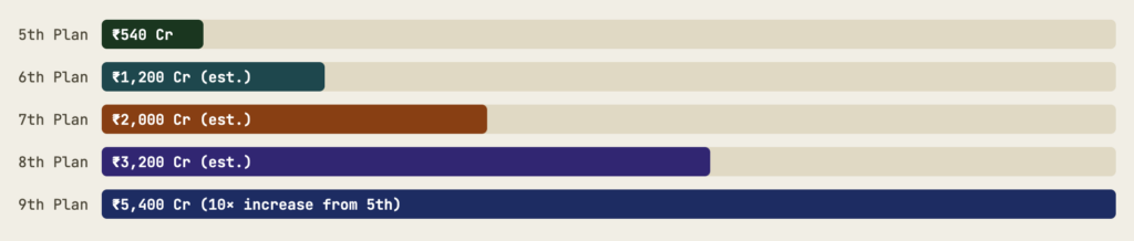
- HADP allocations grew from ₹540 crore (5th Plan) to ₹5,400 crore (9th Plan) — a 10-fold increase reflecting the escalating priority of hill area development.
Utilisation Problem
Despite increased allocation, actual utilisation remains a concern. Nagaland and Arunachal Pradesh have utilised only 60% of their allocated funds under HADP — leaving 40% unspent. Per head allocation of central assistance to North-East India is ₹5,200, but due to lack of proper management, there has been lopsided and even non-utilisation of funds. This paradox — high allocation, low utilisation — reflects the institutional capacity deficit in hill states more than any lack of developmental need.
Physical Infrastructure Development in Hill Areas
In order to strengthen physical infrastructure, the Ministry of Surface Transport and Railways have undertaken various projects to expand and improve roadways, railways, and waterways in hilly regions. There is a comprehensive road map for infrastructure development in the Northeast under Vision 2020 North East.
Road Connectivity — SARDP-NE and BRO
- SARDP-NE (Special Accelerated Road Development Programme for North-East): Comprehensive road development plan targeting construction of 44,000 km of roads in North-East India — connecting district headquarters, border areas, and international trade routes
- High altitude all-weather roads: Border Roads Organisation (BRO) developing 9,000 km of high altitude all-weather roads in North-East — critical for both development and national security
- Char Dham All-Weather Road (Uttarakhand): Connecting four major Himalayan pilgrimage centres (Yamunotri, Gangotri, Kedarnath, Badrinath) through 4-lane highways — connectivity and religious tourism development combined
- Trans-Arunachal Highway: 1,800 km highway connecting all district headquarters of Arunachal Pradesh — addressing the state’s extreme connectivity deficit
Rail Connectivity — Extending to Hill Areas
- Kathgodam-Nainital extension: Extending the Kathgodam terminus rail line to Nainital — bringing rail connectivity to a major hill tourism destination in Uttarakhand
- Kumarghat Terminus to Agartala extension: Extending rail connectivity into Tripura’s capital — critical for an isolated NE state
- Jiribam Terminus to Imphal: Rail extension connecting Manipur’s capital — the Barak Valley to Imphal rail project (now largely complete) ending Manipur’s rail isolation
- Kashmir railway: Udhampur-Srinagar-Baramulla Rail Link (USBRL) — world’s highest rail bridge (Chenab Bridge, 359m) — bringing rail to the Kashmir Valley
- 25 major rail projects in NE: Of which 11 declared National Projects — including Lumding-Sabroom, Rangiya-Murkongselek, Agartala-Akhaura link to Bangladesh
Energy Development in Hill Areas
- North-East India has over 40,000 MW of hydro-power potential — only 2% harnessed; vast scope for power development benefiting both local states and national grid
- Small hydroelectric projects (SHP) for local village electrification — not requiring large dams that displace communities
- Solar mini-grids for remote high-altitude villages beyond grid reach — PM-Surya Ghar scheme applicable to hill areas
- Renewable energy mix (solar + micro-hydro + wind) for hill areas reduces dependence on diesel, which must be transported at enormous cost
Digital Connectivity — The New Infrastructure Frontier
- BharatNet optical fibre network extended to gram panchayats in hill states — internet connectivity reducing market and information isolation
- Satellite-based broadband (OneWeb, Starlink) emerging as solution for extremely remote hill areas beyond terrestrial connectivity reach
- Digital health (telemedicine) and digital education (online schools) transforming service delivery in inaccessible hill villages without physical infrastructure
Infrastructure and Ecological Risk: Large-scale road construction in fragile Himalayan terrain without adequate scientific analysis has caused massive destruction — visible in recurring monsoon landslides. The Char Dham road project drew environmental criticism for blasting through fragile slopes. The current approach of creating large road networks has led to physical damage and destruction in hill areas. Hill infrastructure must be built with respect for geological fragility — using less invasive technologies (tunnels, ropeways, elevated roads) rather than slope-cutting.
Problems in Hill Area Development
Tribal Isolation and Non-Cooperation with Administration
- The tribal dwellers of hilly and forested areas do not cooperate with the administration in development activities due to their isolation from mainstream society. Historical experiences of displacement (dams, industrial projects) and exploitation have created deep mistrust of government-driven development. This is not backwardness but rational self-protection — a response to past harm that must be addressed through rights-based, community-led development approaches rather than top-down implementation.
Militant Outfits Exploiting Tribal Grievances
- Militant outfits in Jammu and Kashmir and tribal areas of North-East have taken advantage of the simplicity of tribes, inciting feelings against the establishment — resulting in violence that makes foreign investors reluctant to invest. Dulhasti project in J&K was abandoned due to militant threats; Kashmir railways face similar challenges. Internal rivalry among tribal groups (Nagas vs. Bodos; inter-tribal conflicts in Manipur) also hampers development.
Improper Utilisation of Allocated Funds
- Per head allocation of central assistance to North-East India is ₹5,200, but due to lack of proper management, there has been lopsided and even non-utilisation of funds. Nagaland and Arunachal Pradesh have utilised only 60% of their allocated funds under HADP. Reasons: weak institutional capacity, poor project preparation, contractor shortages, difficult terrain causing cost and time overruns, corruption and leakages.
Tribes vs. Non-Tribes Conflict
- Increasing hostility between tribes and non-tribes has been a major obstacle in hill development. Influx of migrants from plains — attracted by economic opportunities in hill towns — creates competition for land, jobs, and resources with indigenous hill communities. This is both a security concern and a development challenge — development that brings in outsiders without benefiting locals deepens rather than resolves the conflict.
Extreme Events Overwhelming Regular Funds
- Special allocation of funds is required for handling extreme natural hazard events that cannot be managed by regular development funds. Kedarnath flood (2013), Chamoli disaster (2021), Joshimath subsidence (2023) — each requiring thousands of crores in emergency relief and reconstruction that completely overshadows regular HADP investments. Climate change is making such extreme events more frequent — requiring a permanent disaster risk reduction component in HADP.
Development Benefits Concentrated in Urban Areas
- The people from tribal and hilly areas are not very enthusiastic about developmental activities due to unawareness, poverty, and scattered settlements. The development process is slow and skewed — urban areas within hill regions usually benefit more than rural communities. District headquarters and hill stations receive disproportionate infrastructure investment while remote villages remain isolated. This urban bias within hill area planning reproduces the core-periphery dynamic at a smaller scale.
Accelerating Ecological Degradation from Climate Change
- Climate change is creating new challenges for hill area development that HADP was not designed to address: melting glaciers disrupting water availability for irrigation and drinking; increasing cloudbursts and flash floods destroying infrastructure; changing snowfall patterns affecting water-intensive apple horticulture; rising temperatures pushing agricultural zones upward and threatening mountain-specific crops. The Indian Himalayan Region (IHR) is highly vulnerable to climate change — requiring climate adaptation as a core component of hill area planning.
Circular Migration Depopulating Hill Villages
- Limited livelihood options, poor connectivity, inadequate educational facilities, and lack of healthcare drive circular migration of working-age men from hill villages to plains cities. This leaves behind ageing, women-only villages unable to sustain agricultural productivity. Paradoxically, remittances from migrants fund consumption but not investment — the men return only seasonally. Development that cannot retain local population is ultimately counterproductive.
Solutions for Hill Area Development
- The way forward for hill area development requires:
- Politico-administrative commitment as the need of the hour;
- Focus on people’s participation;
- A comprehensive development scheme for hilly areas.
- Additionally, upgradation of skills of women at Krishi and Van-Vigyan Kendras, and social fencing — voluntary and self-imposed discipline in managing society’s resources at the local level — are essential complementary interventions.
🏛️ Governance & Political Will
- Politico-administrative commitment at highest levels
- Ring-fencing of HADP funds to prevent reallocation
- Decentralised planning through strengthened hill panchayats
- PESA Act implementation in Schedule V hill areas
- Rights-based approach: Forest Rights Act, Community Forest Rights
- Strict enforcement of construction codes in seismic zones
👩🌾 Women’s Empowerment
- Upgradation of skills of women at Krishi Vigyan Kendras (KVK)
- Van-Vigyan Kendras for women’s forestry and NTFP skills
- Women’s SHG network for collective livelihood marketing
- Women as primary decision-makers in land use planning (recognising their role as de facto farm managers)
- Gender-sensitive infrastructure (safe roads, connectivity for healthcare access)
🌱 Social Fencing & Community Management
- Social fencing: voluntary and self-imposed discipline in managing community resources
- Van Panchayat system (Uttarakhand) as model for community forest management
- Joint Forest Management (JFM) with benefit-sharing
- Community-based watershed user associations
- Gram Sabha as primary decision-making body for local resource use
♻️ Sustainable Economy & Livelihood
- GI tags for unique hill products (Darjeeling tea, Kinnaur apple, Nilgiri biosphere honey)
- Eco-tourism regulation with carrying capacity limits
- Climate-resilient horticulture: diversify beyond apple to climate-adapted crops
- Renewable energy: solar mini-grids + micro-hydro for villages
- Agro-processing clusters to add value to hill products locally
- One District One Product (ODOP) for hill districts
🌍 Climate Adaptation
- Climate risk assessment integrated into HADP planning
- Spring rejuvenation programmes to restore himalayan springs (Jal Jeevan Mission hill adaptation)
- Disaster Risk Reduction (DRR) as core HADP component
- Eco-sensitive zone regulations around vulnerable ridges
- Science-based construction protocols for road and dam projects in fragile zones
🔗 Connectivity & Integration
- SARDP-NE completion on schedule for 44,000 km NE roads
- Rail projects: Imphal, Nainital, Kashmir — must be completed
- Ropeways as environmentally lower-impact alternative to roads in fragile zones
- Digital infrastructure: BharatNet + satellite broadband for remote villages
- Helipad network for medical emergency access in remote hill areas





Nice content !! Really helps in geography optional .
Thanku so much ma’am/sir
I was unable to understand the concept now it is crystal clear.