

- The Earth is not a uniform expanse of rock, water and soil but a mosaic of distinct regions defined by their physical conditions and living inhabitants. The largest of these living regions are biomes (Greek bios, life): macro-scale bioclimatic landscapes or biotic areas.
- Formally, a biome is a major world community classified chiefly by its dominant vegetation and marked by the special adaptations of its organisms to that environment: tropical rainforest, savanna, desert, steppe, taiga or tundra.
- Biomes exist because climate sorts life forms. Wherever temperature and moisture are alike, plants of similar form (evergreen broadleaf trees, tussock grasses, cushion plants) evolve, even on continents that share no species.
- Biomes are not fixed. Their boundaries moved with the ice ages and are shifting again under present warming and land conversion.
The Biome Concept

Meaning and definition
- A biome is a broad-scale collection of flora and fauna that differs in detail from one ecosystem to the next but shares common characteristics across its extent.
- Its ecosystems receive similar nutrients and energy, so similar kinds of plants and animals occur throughout, even though individual ecosystems differ in scale, structure and function.
- Origin of the term: Frederic Clements introduced “biome” in 1916, in his address to the first meeting of the Ecological Society of America, for the whole biotic community.
- Clements and Victor Shelford (Bio-Ecology, 1939) tied it to the climax idea: a biome is the plant and animal community of formation rank, in equilibrium with a regional climate.
- Formation and biome: a plant formation is a vegetation unit (rainforest, steppe) recognised by its life forms. It becomes a biome when plants, animals and soils are studied together.
- Some ecologists exclude soils, which evolve far more slowly than biota; others limit biomes to land, because marine units are hard to delimit.
- Green plants dominate every biome physically, since their biomass dwarfs that of animals, so biomes are named after their vegetation.
- Modern consensus: a biome is a large-scale ecosystem, at least sub-continental, defined by climate, dominant plant life form and the functional traits of its organisms.
Biome, ecosystem, ecoregion and realm
- A biome must not be confused with an ecosystem. An ecosystem is the local interaction of living (biotic) communities with their non-living (abiotic) environment; a biome is a broad geographical class containing many interrelated ecosystems that share one macroclimate.
- One tropical rainforest biome holds freshwater river ecosystems, canopy ecosystems and forest-floor decomposer networks.
- Similar biomes recur in widely separated regions wherever the controls are alike: Mediterranean scrub in California, Chile, the Cape, south-west Australia and the Mediterranean basin.
- Their species differ but their life forms converge. A biome is defined by form and climate; a biogeographic realm by shared evolutionary history.
| Unit | Basis | Scale | Example |
|---|---|---|---|
| Ecosystem | Local interactions of biota and environment | Pond to forest stand | A sal forest patch in Chhattisgarh |
| Ecoregion | Distinct assemblage of species within a biome and realm | Thousands to lakhs of km² | Malabar Coast moist forests |
| Biome | Climate and dominant life form | Sub-continental to global | Tropical and subtropical moist broadleaf forests |
| Realm | Shared evolutionary history of lineages | Continental | Indomalayan realm |
What shapes a biome
- The same factors that govern the distribution of plants and animals, namely climate, soil, relief, other organisms and history, shape biomes at the largest scale. The architecture of a biome is set by:
- Plant structure: whether trees, shrubs or grasses dominate.
- Leaf phenology and form: broadleaf or needleleaf, evergreen or deciduous, soft or hard (sclerophyllous).
- Spatial configuration: the density and spacing of plants, from closed-canopy forest through open woodland to scattered savanna trees.
- Macroclimate: latitude, solar radiation, relative humidity, weather systems and regional topography.
- The expansion or contraction of a biome is not a function of temperature alone: precipitation and its seasonality, humidity, wind direction and atmospheric pressure all move its edges.
- Soil, landforms and water also control biomes, through the lithosphere, hydrosphere and cryosphere. Waterlogged, saline or very sandy ground carries azonal vegetation (swamps, mangroves, heath) unlike the climatic type around it.
- Disturbance and history: fire and grazing keep many savannas and grasslands open where the climate could carry forest; continental drift isolated floras; people have cleared, burned and herded for millennia.
- Ecotones: biomes meet along transition belts (forest–savanna, forest–tundra), where species of both mix and an edge effect raises diversity.
Theoretical Frameworks of Biome Classification
- The classification of biomes is not static; it depends on whether a scheme prefers a few broad classes or many sub-classes.
- Broad consensus systems recognise five or six foundational biomes: forest, grassland, freshwater, marine, desert and tundra. Deeper ecological work uses more rigorous models.
Three orders of biomes
- A classical hierarchy, built on the close link between world climates and vegetation, groups land biomes in three orders:
| Order | Basis | Biomes |
|---|---|---|
| First | Climatic zone | Tundra; Temperate; Tropical |
| Second | Dominant vegetation | Tundra: arctic, alpine. Temperate: boreal (taiga), temperate deciduous forest, temperate grassland, Mediterranean, warm temperate. Tropical: tropical forest, savanna, desert |
| Third | Regional variants | Taiga: North American, Asiatic, mountain forest. Temperate grassland: Russian steppe, prairie, pampa, Australian grassland. Tropical forest: evergreen, semi-evergreen, deciduous, semi-deciduous, montane, swamp. Savanna: savanna forest, savanna grassland. Desert: arid, semi-arid |
The Whittaker biome diagram
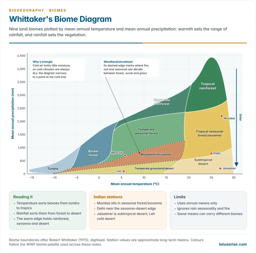
- Robert Whittaker (1970, 1975) charted land biomes against two independent climatic variables: mean annual temperature (MAT) on the horizontal axis and mean annual precipitation (MAP) on the vertical axis. Vegetation types fall into predictable fields.
- Shape of the diagram:
- It is roughly a triangle: very wet climates exist only where it is warm, because cold air holds little moisture. Cold climates occupy a narrow precipitation range, warm climates the full range.
- Tundra occupies the cold, dry corner (MAT below about −5 °C), boreal forest about −5 to +5 °C; temperate forests, grasslands and woodlands fill the middle.
- Along the warm edge, falling rainfall turns rainforest into seasonal forest and savanna, then desert: the whole moisture gradient in one column.
- Woodland and shrubland occupy a broad central band where soil, fire and the seasonality of rain decide between forest, scrub and grassland; Whittaker drew it with a dashed boundary for that reason.
- Limit: annual means hide seasonality. A Mediterranean climate and a summer-rain grassland can share the same MAT and MAP.
Heinrich Walter’s zonobiomes
- In contrast to Whittaker’s annual averages, Heinrich Walter evaluated the seasonality of temperature and precipitation, recorded on his climate diagrams (with Helmut Lieth, 1960s).
- He mapped nine zonobiomes (ZB I–IX), each with its own zonal soil and vegetation. Cold stress and drought stress, not annual totals, are the real gatekeepers of plant form.
- Two regions with identical annual rainfall are separated if one has rain all year and the other a long summer drought.
- Departures from the zonal type: orobiomes (altitudinal belts of mountains), pedobiomes (vegetation of unusual soils: saline, sandy, waterlogged) and zonoecotones (broad transitions such as forest-steppe).
| Zonobiome | Climate | Zonal vegetation | Zonal soil |
|---|---|---|---|
| ZB I Equatorial | Humid all year | Tropical evergreen rainforest | Ferralsols (latosols) |
| ZB II Tropical | Summer rain, winter drought | Deciduous forest, savanna | Red earths, vertisols |
| ZB III Subtropical arid | Hot desert | Desert vegetation | Desert soils (aridisols) |
| ZB IV Mediterranean | Winter rain, summer drought | Sclerophyllous woodland and scrub | Mediterranean brown and red soils |
| ZB V Warm temperate | Humid, mild winters | Temperate evergreen forest | Red and yellow podzolic soils |
| ZB VI Nemoral (typical temperate) | Short cold winter | Deciduous broadleaf forest | Brown earths, grey forest soils |
| ZB VII Continental arid | Cold winter, dry | Steppe to cold desert | Chernozems to sierozems |
| ZB VIII Boreal | Cold temperate, short summer | Coniferous forest (taiga) | Podzols |
| ZB IX Polar | Arctic and antarctic | Tundra | Tundra (gley) soils with permafrost |
Other schemes
- Holdridge life zones (Leslie Holdridge, 1947): a triangular grid of biotemperature, annual precipitation and the ratio of potential evapotranspiration to rainfall, giving dozens of life zones repeated by latitude and altitude.
- Köppen: Wladimir Köppen drew his climate boundaries partly from vegetation limits, so the Köppen classification and the climatic regions of the world match the biomes closely: Af with rainforest, Aw with savanna, BW with desert, Cs with Mediterranean scrub, Dfc with taiga, ET with tundra.
The WWF scheme: 14 terrestrial biomes
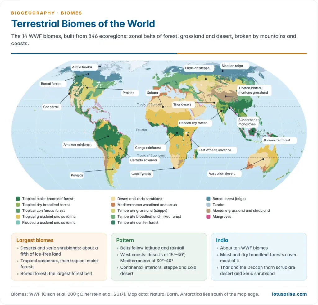
- The WWF map (David Olson and others, 2001; updated by Eric Dinerstein and others, 2017) divides the land into 846 ecoregions, grouped into 14 biomes and 8 biogeographic realms: the standard base for global conservation planning.
- It separates forests by temperature and leaf type and grasslands by temperature and flooding, and treats mangroves and montane grasslands as biomes of their own.
| WWF biome | Share of ice-free land (approx.) | Typical regions |
|---|---|---|
| Deserts and xeric shrublands | 20% | Sahara, Arabia, Thar, Australia, Atacama, Gobi |
| Tropical and subtropical grasslands, savannas and shrublands | 16% | Sudan–Guinea and East African savannas, Cerrado, northern Australia |
| Tropical and subtropical moist broadleaf forests | 15% | Amazon, Congo, Borneo, Western Ghats, North-east India |
| Boreal forests/taiga | 12% | Canada, Alaska, Scandinavia, Siberia |
| Temperate broadleaf and mixed forests | 9% | Eastern USA, Europe, eastern China, Himalaya |
| Temperate grasslands, savannas and shrublands | 8% | Prairies, steppes, pampas, veld |
| Tundra | 6% | Arctic coasts and islands |
| Montane grasslands and shrublands | 4% | Tibetan Plateau, Andean páramo and puna, East African highlands |
| Tropical and subtropical dry broadleaf forests | 3% | Central India, Deccan, Mexico, Madagascar |
| Temperate conifer forests | 3% | Pacific North-west, Himalayan conifer belts |
| Mediterranean forests, woodlands and scrub | 2.5% | Mediterranean basin, California, Chile, Cape, south-west Australia |
| Flooded grasslands and savannas | 1% | Sudd, Pantanal, Okavango, Rann of Kachchh |
| Tropical and subtropical coniferous forests | 0.5% | Mexico, Central America, Caribbean, Himalayan chir pine belt |
| Mangroves | 0.2% | Sundarbans, Indonesia, Brazil, Nigeria |
Productivity of biomes
- Net primary productivity (NPP), the organic matter plants add after their own respiration, falls from warm, wet biomes to cold or dry ones, tracking the Whittaker gradient.
| Biome | Area (million km²) | Mean NPP (g dry matter/m²/year) | Total NPP (billion tonnes/year) |
|---|---|---|---|
| Tropical rainforest | 17.0 | 2,200 | 37.4 |
| Tropical seasonal forest | 7.5 | 1,600 | 12.0 |
| Temperate deciduous forest | 7.0 | 1,200 | 8.4 |
| Boreal forest | 12.0 | 800 | 9.6 |
| Savanna | 15.0 | 900 | 13.5 |
| Mediterranean woodland and scrub | 8.5 | 700 | 6.0 |
| Temperate grassland | 9.0 | 600 | 5.4 |
| Tundra and alpine | 8.0 | 140 | 1.1 |
| Desert and semi-desert scrub | 18.0 | 90 | 1.6 |
| Extreme desert, rock, sand and ice | 24.0 | 3 | 0.07 |
| Open ocean | 332.0 | 125 | 41.5 |
- In this classic estimate by Robert Whittaker and Gene Likens (1975), tropical rainforests produce about a third of all land NPP from roughly a ninth of the land. Deserts, tundra and the open ocean are the biological deserts at the low end.
A. Terrestrial Biomes
1. Forest Biomes
- Forests are large areas dominated by trees. By climate and kind of tree they are grouped into tropical rainforests, tropical deciduous (monsoon) forests, temperate deciduous forests and boreal (northern coniferous) forests.
- Tropical forests hold about 45% of the world’s forest area and boreal forests about 27% (FAO, 2020).
Tropical rainforest biome
- Location: low-altitude areas near the equator, mostly 10°N–10°S: the Amazon basin, the Congo basin and West Africa, and the Indo-Malayan region and New Guinea.
- It reaches farther on rain-fed windward coasts: Veracruz in Mexico (about 19°N), eastern Madagascar and Brazil’s Atlantic Forest (towards 30°S).
- Although these areas are physically isolated, their forests show great similarity of structure and function. It is called the optimum biome, as neither heat nor moisture ever limits growth.
- Climate (Köppen Af):
- Monthly means of 25–28 °C, an annual range of only 1–3 °C and a daily range of 5–10 °C, larger than the annual one.
- Rainfall above 2,000 mm, every month wet, mostly as convectional afternoon downpours. Humidity is high and the growing season continuous.
- Soils: Ferralsols (oxisols, latosols), deep and intensely weathered by laterisation; silica is leached, leaving iron and aluminium oxides and nutrient-poor kaolinite clay.
- The humus layer is thin, not rich: litter decays within weeks, and almost all nutrients sit in the living biomass. Nutrient cycling is rapid and tight, with root mats and mycorrhizal fungi recapturing nutrients from the litter.
- If the canopy is removed, the soil soon becomes infertile, and exposed laterite can harden into crust.
- Vegetation:
- A broad-leaved evergreen forest of dense growth and extreme diversity: a hectare in western Amazonia can hold about 300 tree species, against a few dozen in a temperate forest.
- All green plants strive to reach the light: they grow very tall, climb, or live as epiphytes (plants growing on other plants without drawing food from them).
- Tree features: tall straight trunks, buttress roots, thin bark, dark leathery leaves with thick cuticles against strong sunlight, and drip tips that shed water quickly; many flower on the trunk (cauliflory).
- Lianas (woody climbers up to 200 m long) bind the canopy into a web; rainforests hold about 90% of all climbing species. Epiphytes include orchids, bromeliads, ferns and mosses; hemi-epiphytes such as strangler figs send roots down to the soil.
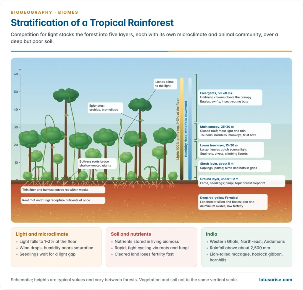
- Vertical stratification: competition for light builds five strata:
- Emergents of 30–60 m or more, with umbrella crowns; the tallest known tropical tree, a yellow meranti in Sabah, Borneo, is about 100 m;
- the main canopy at 25–30 m, a nearly continuous layer that intercepts most light and rain;
- a lower tree layer at 15–20 m, with larger leaves to catch scarce light;
- a broken shrub layer of about 5 m, with saplings;
- a sparse ground layer of herbs and ferns, since only about 1–3% of sunlight reaches the floor.
- Downward through the strata, light and wind fall and humidity rises. Seedlings wait in the dark until a fallen tree opens a light gap.
- Fauna:
- Rich and largely arboreal: monkeys, apes, sloths, flying squirrels, snakes, tree frogs, birds and countless insects live in the trees, where the bulk of the foliage is. Climbing aids include claws, adhesive pads and prehensile tails; flying squirrels, lizards and frogs glide.
- Food is available all year, so animals rarely migrate, and the forest is active day and night.
- Animal strata follow the plant strata:
| Animal community | Typical members |
|---|---|
| Above the canopy | Fast-flying insect-eating birds and bats (swifts, falconets) |
| Main canopy | Fruit-eating birds and bats, monkeys, squirrels (toucans, hornbills, parakeets) |
| Middle zone, flying | Birds and insectivorous bats |
| Middle zone, climbing | Squirrels, civets, monkeys, lizards, moving along lianas between strata |
| Large ground animals | Forest elephants, okapi, tapirs, gorillas, pigs, mouse deer, cassowaries |
| Small ground animals | Pheasants, junglefowl, rodents, and hidden (cryptozoic) animals in the litter |
- Ground animals are smaller than their open-country relatives: the forest elephant is smaller than the savanna elephant. Snails, centipedes, millipedes and many insects work the forest floor.
- Ecological significance:
- The most diverse and productive land ecosystem, with mean NPP of about 2,200 g/m²/year.
- Gene pool: on only about 7% of the land surface today it holds an estimated half or more of all land species, the source of many foods, drugs (quinine, curare, vincristine) and crop relatives.
- Carbon and water: a huge carbon store; evapotranspiration recycles much of the rain, and the Amazon’s “flying rivers” carry moisture to southern Brazil and the La Plata basin.
- Soil protection on steep, rain-lashed slopes, and the homes of forest peoples: the Yanomami of Amazonia, the Mbuti and Baka of the Congo, the Penan of Borneo.
- Human use: shifting cultivation (jhum in North-east India, milpa in Central America, ladang in Indonesia), gathering and hunting, plantations (rubber, oil palm, cocoa), logging, cattle ranching and soya in Amazonia, mining and dams.
- India: tropical wet evergreen forests where rainfall exceeds about 2,500 mm, in the Western Ghats (Silent Valley, Agumbe), North-east India (Namdapha, Dihing Patkai) and the Andaman and Nicobar Islands.
- Typical trees are dipterocarps, rosewood, ebony and Mesua; animals include the lion-tailed macaque, the hoolock gibbon (India’s only ape), the Malabar giant squirrel and the great hornbill.
- Current threats:
- Tropical primary forest loss set a record in 2024, then fell 36% to about 4.3 million ha in 2025, still far above a decade earlier (Global Forest Watch, 2026); fire causes a growing share.
- About 20% of the Amazon is cleared and 6% badly degraded. A 2024 study warned that 10–47% of the Amazon could face compounding drought, heat and clearing by 2050, risking a shift to degraded, savanna-like vegetation.
- Clearing for cattle, soya, oil palm and timber, with mining and fire, drives tropical deforestation. In India, the Great Nicobar development project threatens a large block of island rainforest.
Tropical deciduous (monsoon) forest biome
- Monsoon forest, also called dry forest or tropical deciduous forest, is often open and grades into woodland, with shrubs and grasses in the gaps.
- Unlike rainforest it is deciduous: most trees shed their leaves in the long dry season, which comes at the time of low sun and cooler temperatures.
- Location: the wet–dry tropics, mostly 10°–25° N and S: South and South-east Asia (India, Sri Lanka, Bangladesh, Myanmar, Thailand, Cambodia, Laos, Vietnam), East Africa and western Madagascar, northern Australia, Central America, the West Indies and eastern Brazil.
- Climate (Köppen Am, Aw):
- A long rainy season alternates with a dry, rather cool season. India has a hot dry summer (March–June, maxima of 38–48 °C), a warm wet season (July–October) and a dry winter (10–27 °C).
- Rainfall of about 1,000–2,000 mm, 80% or more in three or four monsoon months. The length of the dry season matters more than the annual total.
- Soils: red and yellow soils, laterites on wet uplands, and black soils (vertisols) on the Deccan basalts; leaf fall gives a seasonal pulse of litter.
- Vegetation:
- Fewer species and lower density than rainforest, so less competition for light. Trees are mostly 12–30 m tall in four strata: two tree layers, an often evergreen shrub layer and a ground layer.
- Trees have thick, rough bark and either large leaves shed in the dry season or small, hard xerophytic leaves; climbers and epiphytes are far fewer.
- Moist deciduous forests (about 1,000–2,000 mm) carry teak, sal, Terminalia, shisham and bamboo. Dry deciduous forests (about 500–1,000 mm) carry teak, tendu, Anogeissus, palas and khair, grading into thorn forest.
- The teak of the monsoon forests of southern Asia was once abundant, but much was cut and exported to the West for furniture, panelling and decking.
- Fauna: fewer species than rainforest because the vertical structure is simpler; breeding and movement follow the seasonal rhythm of leaf and grass.
- Large mammals include elephant, tiger, leopard, gaur, sambar, chital, sloth bear, dhole, and the Asiatic lion in the dry teak forests of Gir and the wider Saurashtra landscape, Gujarat (891 lions in the 2025 count).
- Human use: the biome carries the largest human population and the most domestic animals of any tropical biome: settled farming, shifting cultivation, timber (teak, sal) and minor forest produce (tendu leaves, mahua, lac, sal seed) for forest-dwelling communities.
- India: the most extensive forest type of India: sal in the Shiwalik foothills, Chota Nagpur and Odisha; teak in the Western Ghats, Madhya Pradesh and Maharashtra.
- Current threats: one of the most disturbed ecosystems in the world.
- Dry-season fires (lightning, carelessness, deliberate burning for jhum and fresh grazing), heavy grazing, mining in the coalfields of central India, and encroachment.
- Clearing has accelerated rill and gully erosion, river siltation and floods, and invasive Lantana camara has overrun much of the understorey.
Temperate deciduous forest biome
- Location: forests of broad-leaved deciduous trees once covered most of western and central Europe, eastern North America and eastern Asia, with small areas in Patagonia and Australia.
- In Western Europe it goes with the marine west-coast climate; the dominant trees are oak and ash, with beech in cooler, moister areas. In Asia it forms a belt between the boreal forest to the north and the steppe to the south.
- Climate (Köppen Cfb, Cfa, Dfa, Dfb): a moderate 500–1,500 mm spread through the year, a growing season of four to six months and higher light intensity. The temperature regime lacks extremes, but a marked cold season must be endured; the climate is less extreme than the boreal forest’s.
- Soils: mostly brown earths (Cambisols) and grey-brown podzolic soils (Luvisols, Alfisols).
- Larger amounts of nutrients are used and move faster than in the boreal forest. Autumn leaf fall returns nutrients in bulk, and the nutrient-rich litter decays under bacteria and earthworms into mildly acid, crumbly mull humus.
- Vegetation:
- Trees drop their leaves in the cold season, a physiological drought when soil water is frozen. Common trees are oak, beech, birch, hickory, walnut, maple, elm, ash and chestnut.
- Four layers: a canopy of 20–35 m, smaller trees, shrubs and herbs. Herbs such as bluebells flower in spring before the canopy leafs out, and autumn brings leaf colouring.
- Where these forests are cleared by lumbering, pines readily develop as second-growth forest.
- Fauna: deer (white-tailed, red, roe), black and brown bears, wild boar, wolves (once widespread), foxes, badgers, squirrels and songbirds; many animals hibernate, store food or migrate for winter.
- Human use: probably more modified by human activity than any other biome. Its fertile soils became the farmland, towns and industrial heartland of Europe, the eastern USA and eastern China; primeval fragments survive at Białowieża on the Poland–Belarus border.
- Related forests: temperate rainforests on cool, wet west coasts (Pacific North-west, southern Chile, New Zealand) and temperate conifer forests in drier or mountain areas.
- India: the Himalayan temperate broadleaf forests at about 1,500–2,500 m: oaks (banj, moru, kharsu), rhododendron, maple, walnut, horse chestnut and laurels, with the red panda and Himalayan black bear. The Chipko movement (1973) began in these Garhwal forests.
- Current threats: fragmentation, imported pests and diseases (ash dieback, emerald ash borer, chestnut blight), deer overbrowsing and nitrogen deposition.
Boreal forest (taiga) biome
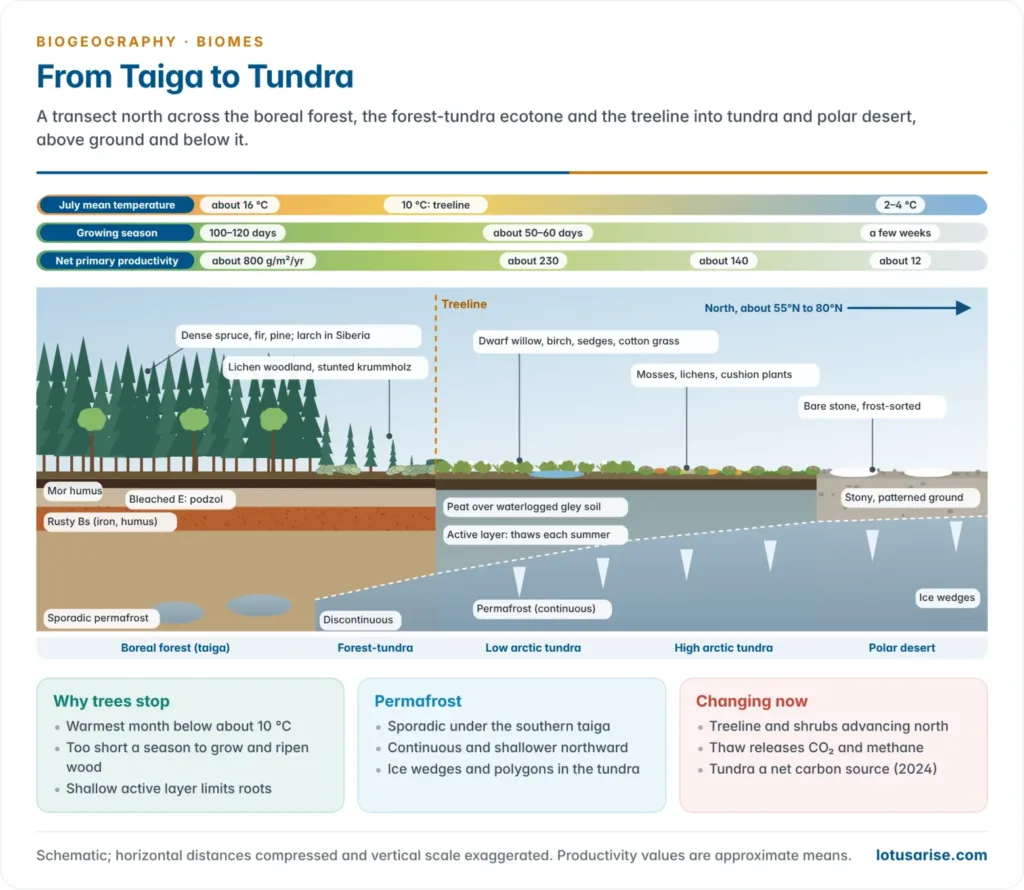
- Boreal forest is the cold-climate needle-leaf forest of high latitudes, in two great continental belts, North America and Eurasia, spanning the land masses from west to east between about 45°N and 70°N.
- These belts closely match the subarctic (boreal-forest) climate. It is the largest forest biome, with no southern-hemisphere counterpart because there is no land at those latitudes.
- Climate (Köppen Dfc, Dfd):
- Low temperatures all year. The warmest month averages above 10 °C, which lets trees grow, but winters fall many degrees below freezing, to about −50 °C in north-east Siberia, and permafrost often extends into the northern forest.
- The growing season lasts only three or four months, and solar energy is small even then.
- Precipitation of 400–700 mm, mostly snow, whose weight can damage trees.
- Landscape and soils:
- Severe glacial and periglacial activity has left subdued relief and abundant surface water: lakes, bogs and muskeg.
- Needle litter is acid and nutrient-poor; decomposition is mostly fungal, since bacteria are slow in the cold, giving acid mor humus.
- The typical soil is the podzol (spodosol), strongly leached and highly acidic, with peat in hollows and permafrost soils in the north.
- Vegetation:
- Conifers form dense canopies that intercept much light and precipitation, so it is dark and dry beneath, with little undergrowth.
- Species-poor: evergreen spruce, fir and pine in North America, Europe and western Siberia; larch in north-central and eastern Siberia. Larch sheds its needles in winter: a deciduous needle-leaf tree.
- Adaptations: needle leaves with thick cuticles cut water loss; the conical shape sheds snow; evergreenness lets photosynthesis start as soon as spring arrives.
- Birch, aspen and willow recolonise after fire; toward the tundra the forest opens into lichen woodland.
- Conifers of low nutrient demand, low diversity and the harsh climate make the nutrient cycle slow and impoverished.
- Fauna: moose, woodland caribou, wolf, lynx and snowshoe hare (whose numbers cycle about every ten years), brown bear, wolverine, sable, the Amur tiger in the mixed forests of the Russian Far East, crossbills and summer insect swarms that feed migrant birds.
- Human use: timber, pulp and paper (Canada, Russia, Sweden, Finland), fur trapping, mining and the Alberta oil sands, hydropower (James Bay) and reindeer herding.
- India: no true taiga, but the Himalayan subalpine forests at about 2,800–3,800 m (silver fir, spruce, blue pine, Himalayan birch) are its ecological analogue.
- Current threats: fire (Canada’s 2023 season burned a record 17.2 million ha, more than double the 1989 record), bark-beetle outbreaks, permafrost thaw and logging of intact forest.
- The treeline is advancing north while interior drought kills trees; unlike the tundra, the boreal forest remains a carbon sink.
2. Grassland Biomes
- Grasslands are areas dominated by grasses. With savannas they cover about a fifth or more of the land, in tropical and temperate regions where rainfall is too low or seasonal, or fire and grazing too frequent, for continuous trees. They have well-defined dry and rainy seasons and many local names.
| Region | Name of the grassland |
|---|---|
| North America | Prairies |
| Eurasia | Steppes (puszta in Hungary) |
| Africa | Savanna; veld in South Africa |
| South America | Pampas (temperate); llanos, campos and cerrado (tropical) |
| Australia | Downs |
| New Zealand | Canterbury tussock grassland |
| India | Grasslands and savannas (Deccan, Banni, Terai, Himalayan alpine meadows) |
- Grasslands contrast with forests:
- Much smaller biomass, a large share of it in roots.
- Grasses intercept less precipitation than trees, except at peak growth; the grass form aids stemflow, and surface run-off is greater than from forested slopes.
- NPP is roughly half that of an adjacent forest, but the standing crop is far smaller, so nutrient reservoirs are limited and held mostly in roots and soil.
- Two main types are distinguished: temperate grasslands, where woody growth is absent or negligible, and tropical grassland (savanna), where scattered trees are much more common.
Savanna biome
- Meaning: to climatologists, savanna is the tropical wet-and-dry climate (Köppen Aw); to botanists, a tropical vegetation of grasses with scattered trees and shrubs. The biome has a ground cover of partly xeromorphic grasses, a middle layer of sparse shrubs and an upper layer of scattered trees.
- Location: about 5°–20° N and S, flanking the equatorial forests: the llanos of Venezuela and Colombia, the campos and cerrado of Brazil; the Sudan and Guinea savannas, East Africa (Serengeti) and the miombo woodlands of Africa; northern Australia; and India.
- Climate (Köppen Aw):
- Distinct wet and dry seasons, high temperatures and abundant sunshine; no month is cooler than about 18–20 °C.
- Rainfall runs from 250–500 mm on the desert fringe to 1,300–2,000 mm near the rainforest, 80–90% in the wet season; the dry season lasts four to eight months.
- Three seasons: a cool dry season (days 26–32 °C), a hot dry season (32–38 °C) and a warm wet season.
- The Indian savanna has the greatest extremes, 45–48 °C in May–June and 5 °C or less in January, with under 1,500 mm in about three months.
- Soils: mostly Ferralsols. Many have near-surface lateritic crusts (ferricrete), an impermeable layer in which nutrients, especially phosphates and nitrates, are markedly lacking. Termite mounds recycle nutrients and mix the soil.
- Vegetation:
- Rain-green: the brown, withered grasses of the dry season give way rapidly to tall, lush growth with the summer rains.
- Grasses are coarse, tufted perennials, mostly under 1 m but up to 3.5 m; elephant grass reaches 5 m. Genera include Hyparrhenia, Panicum, Pennisetum, Andropogon, Themeda and Imperata.
- Trees are 6–12 m tall with flat-topped (umbrella) crowns: acacias, the baobab (which stores water in its swollen trunk) and dom palm in Africa, eucalyptus in Australia, pines in Honduras.
- Adaptations: deep roots (5–20 m) to groundwater, leaf shedding or leathery leaves in the dry season, thick fire-resistant bark and protected buds (pyrophytes), and root tubers that store water.
- Tree cover ranges from about 50% to nil; the greater diversity of tropical over temperate grasslands comes largely from these woody plants.
- Four types: woodland (closed) savanna, usually in a belt next to the rainforest with an open, park-like look; tree savanna (scattered trees over grass); shrub savanna (shrubs over grass); and grass savanna (grass alone, with bare patches).
- Origin: is savanna a climatic climax?
- Climate: too little soil moisture in the long dry season to support full tree cover, so trees stand far apart.
- Fire sweeps most savannas each dry season. The trees are fire-resistant; fire regenerates grass, mineralises litter and kills seedlings of forest trees.
- Herbivores and people: browsing elephants and millennia of burning and herding. Much African savanna is a delicate balance of climate, soils, vegetation, animals and fire, partly created by people rather than a pure climatic climax.
- Soils: lateritic crusts and nutrient-poor soils exclude trees in places.
- Current view: between about 1,000 and 2,500 mm of rain, forest and savanna are alternative stable states, and fire decides which one holds. This is why savanna boundaries correlate poorly with rainfall and the length of the rainy season, and why, like prairies, savannas show little ecotone development against the rainforest.
- Fauna:
- The African savanna has the world’s greatest variety of large grazing mammals: about 40 species of large herbivores in East Africa, up to 16 grazing together. With them come predators: lions, leopards, cheetahs, hyenas, jackals and wild dogs. Elephants are the largest animals of the savanna and adjacent woodland.
- Grazing succession limits competition: the giraffe browses treetops, the zebra crops coarse grass heads, the wildebeest grazes medium grass and the gazelle short grass.
- Seasonal movement: some species stay put (giraffe, hartebeest); buffalo, zebra, wildebeest, eland and elephant migrate in the dry season, as in the Serengeti–Mara migration of over a million wildebeest.
- Elsewhere: kangaroos (about 50 species) and the emu in Australia; rhea, giant anteater and maned wolf in South America.
- Termites are the key decomposers, moving tonnes of soil and plant matter per hectare each year.
- Productivity: mean NPP about 900 g/m²/year, from about 1,500 in woodland savanna to 200 in desert-scrub savanna; where large herds survive, animal biomass is among the highest of any ecosystem.
- Human use: pastoralism (Maasai, Fulani), ranching, millet, groundnut and cotton farming, wildlife tourism (Serengeti, Kruger) and the soya and cattle frontier of the Brazilian cerrado.
- India: Indian savannas are mostly derived: they arose within and around deciduous forests after long clearing, burning and grazing, and are dominated by shrubs rather than grasses.
- They cover the Deccan plateau, Banni (Kachchh) and semi-arid fringes; the Terai and Brahmaputra floodplains carry tall-grass flooded savannas (Kaziranga, Manas, Dudhwa) with the one-horned rhino.
- Animals include the blackbuck, chinkara, Indian wolf, Great Indian Bustard and lesser florican. The cheetah, extinct in India since 1952, was reintroduced at Kuno in 2022.
- Current threats:
- Conversion: in 2023, for the first time, Brazil’s cerrado lost more native vegetation than the Amazon, about 1.1 million ha.
- Woody encroachment (bush thickening) from overgrazing, fire suppression and rising CO₂ across Africa and Australia; poaching and fencing cut migration routes.
- In India, savannas have long been misclassified as “wastelands” or degraded forest; a 2024 remote-sensing study warned that tree planting on them destroys an ancient ecosystem.
Temperate grassland biome
- Location: continental interiors in the westerly belt, too far from the sea for enough rain to support trees. Southern-hemisphere grasslands lie on the south-eastern margins of the continents, so their climate is milder.
- The Eurasian steppes are the most extensive, over 3,200 km from the Black Sea across the Russian plain to the Altai, with outliers in Hungary (puszta) and Manchuria.
- The prairies run from the Rockies foothills east to the deciduous forest. The southern hemisphere has the pampas of Argentina and Uruguay, the veld of South Africa, the downs of the Murray–Darling basin and the Canterbury grassland of New Zealand.
- Climate (Köppen BSk, Dfa, Dfb):
- Continental extremes in the north: Winnipeg’s July exceeds 20 °C and its January falls to about −20 °C, an annual range near 40 °C, against 10–12 °C in the southern hemisphere.
- Precipitation of 250–750 mm, mostly in early summer; the Eurasian steppe lies under snow for months.
- Soils: the richest farm soils on Earth. Grass roots decay in place each year, building a deep, dark, humus-rich A horizon, while low rainfall leaves a calcium carbonate layer at depth.
- These pedocals are chiefly chernozems (black earths) and drier kastanozems (chestnut soils), Mollisols in soil classification.
- Across the Russian steppe, soils change southward with rainfall: degraded chernozems and grey forest soils, true chernozem, chestnut soils, then grey desert soils (sierozems).
- Vegetation:
- Perennial grasses form the climax, with flowering herbs (forbs); trees grow only on steep slopes or near water.
- Single-layered: the canopy is formed by leaves, joined briefly by flowering stalks. Grass flowers lack petals; wind pollinates them and disperses the seed.
- Roots outweigh shoots: roots reach 2 m while shoots stand 0.6–1.2 m, and root biomass (about 2,000 g/m²) exceeds shoot biomass (about 1,600 g/m²).
- Tall-grass prairie has tall grasses with forbs. Steppe, or short-grass prairie, has sparse clumps of short grasses, grading into semi-desert in dry areas and into prairie where rain is higher.
- Origin: mostly climatic (continental drought), though fire and grazing helped keep them treeless.
| Region | Sub-types and rainfall | Dominant grasses |
|---|---|---|
| Eurasian steppe | Forest-steppe (500–600 mm): oak, lime, elm, maple in Europe; birch, aspen, willow in Siberia. Meadow and grass steppe (400–500 mm) on deep chernozem. Semi-arid steppe (300–350 mm) on chestnut soils | Feather grass (Stipa), fescue (Festuca); wormwood (Artemisia) in the south |
| North American prairie | Tall-grass (east, about 1,000 mm), mixed (Great Plains), short-grass (west, about 400 mm) | Big bluestem and switch grass (1.5–2.5 m); needle grass; buffalo grass and blue grama (under 60 cm) |
| Pampas | Humid pampa (east, 900 mm), sub-humid pampa (west, 450 mm) | Briza, Bromus, Paspalum, Panicum, Lolium; lucerne introduced |
| South African veld | Plateau at 1,500–2,000 m: Themeda (red grass) veld, sour veld, alpine veld in the Drakensberg | Red grass (Themeda triandra), Aristida, Eragrostis |
| Australian downs | Tall, short and xerophytic grasslands as rainfall falls inland | Kangaroo grass (Themeda), Poa tussock, Danthonia, Stipa; mulga scrub |
| Canterbury, New Zealand | Short and tall tussock grassland | Festuca, Poa, Chionochloa |
- Climate links: prairies match the drier parts of the moist continental climate, steppes the semi-arid continental climate, and the pampa a moist subtropical climate with mild winters.
- Fauna:
- Each region is dominated by a few large grazers: bison and pronghorn in the prairies, saiga, Przewalski’s horse and Mongolian gazelle in the steppes, guanaco and pampas deer in the pampas, antelopes in the veld, kangaroos in the downs.
- Burrowing rodents abound (prairie dogs, gophers, sousliks, viscacha, mole rats). Jackrabbits and jumping mice leap to see over the grass; grazers are fast, sturdy and herd-living, and many migrate.
- Predators include wolves, coyotes, foxes, eagles, hawks and rattlesnakes. Flightless running birds fill one niche on three continents: rhea, emu and ostrich. New Zealand’s giant moas were hunted to extinction.
- Uniqueness of the Eurasian steppe:
- The largest continuous temperate grassland on Earth, from Hungary to Manchuria, with a classic north–south zonation of forest-steppe, grass-steppe and semi-arid steppe matched by soils.
- Severe continentality, with the largest annual temperature ranges of any grassland and long snow cover.
- Its own fauna (saiga, Przewalski’s horse, Mongolian gazelle, steppe eagle, bobak marmot) and a long history of horse-borne nomadic pastoralism, from the Scythians to the Mongols.
- Much was ploughed for wheat, notably in the Soviet Virgin Lands campaign (from 1954). The saiga recovered from a few tens of thousands in 2005 to over 1.9 million in Kazakhstan, and the IUCN moved it from Critically Endangered to Near Threatened in December 2023.
- Human use: the “granaries of the world“. Tall-grass prairie gives rich land for cultivation; short-grass prairie occupies vast semi-arid areas suited to grazing. Wheat and maize dominate the prairies, the Kazakh steppe and the pampas, and the drier fringes became cattle and sheep ranches.
- India: no true temperate grassland; the nearest analogue is the cold Trans-Himalayan steppe of Ladakh (Changthang) and Spiti, grazed by pashmina goats, yaks, the kiang and Tibetan gazelle.
- Current threats:
- The least protected biome, with the highest ratio of converted to protected land; only a few per cent of the tall-grass prairie survives.
- The bison fell from tens of millions to under a thousand by 1889 through mass hunting; prairie dogs and their predators declined with ploughing.
- The Dust Bowl (1930s): ploughing and drought let wind strip the loose soils of western Kansas, Oklahoma and Texas.
- Exotic species: European rabbits and sheep in Australia, and clovers and ryegrass that suppressed native grasses. Overgrazing and land-use change still degrade rangelands from Mongolia to the Sahel.
3. Desert Biome
Hot deserts
- The desert is a highly evolved ecosystem supporting a multitude of plants and animals built to save and find water. The biome includes semi-desert and dry desert in the tropical, subtropical and mid-latitude dry climates; deserts and xeric shrublands are the largest WWF biome, about a fifth of the ice-free land.
- Location:
- Tropical deserts at about 15°–30° N and S on the western sides of continents, under the subtropical highs and beside cold currents: the Sahara, Arabian, Thar, Kalahari, Namib, Atacama, Sonoran and Australian deserts.
- Mid-latitude (cold-winter) deserts in continental interiors and rain shadows: the Gobi, Taklamakan, Turkestan, Patagonian and Great Basin deserts.
- Climate (Köppen BWh, BWk):
- Rainfall below about 250 mm, highly unreliable and unevenly spread: years of drought broken by a single storm.
- Extremes of temperature, with daily ranges of 20–30 °C. Air temperatures exceed 50 °C in the Sahara and Death Valley, and satellites have measured ground temperatures near 70 °C in Iran’s Lut desert.
- Potential evaporation far exceeds rainfall, and strong winds move sand and dust.
- Soils: thin, coarse and poor in humus: Aridisols, sand (Arenosols), calcrete and gypsum crusts, saline soils in basins and grey desert soils (sierozems).
- Vegetation:
- Desert plants vary widely in appearance; the biome includes formation classes transitional from grassland and savanna into true desert.
- Semi-desert, from the tropical to the mid-latitude zone, consists mainly of sparse xerophytic shrubs, such as the sagebrush of the middle and southern Rockies and the Colorado Plateau.
- Dry desert has plants widely dispersed: small, hard-leaved or spiny shrubs, succulents (cacti) and hard grasses. Many small annuals appear only after rare, heavy downpours.
- In the Mojave and Sonoran deserts plants are often large, giving the look of woodland: the saguaro cactus and the Joshua tree.
- Drought evaders (ephemerals) finish their life cycle in weeks after rain; succulents store water; drought endurers have deep roots or dormant stems. American cacti and African euphorbias look alike though unrelated: convergent evolution.
- Plant adaptations to hot, dry conditions:
- Mostly shrubs, widely spaced.
- Leaves absent or reduced to scales or spines, with thick cuticles and sunken stomata.
- Leaves and stems succulent and water-storing; in some plants even the stem contains chlorophyll for photosynthesis.
- CAM photosynthesis, with stomata open only in the cool night.
- Root systems well developed: widespread and shallow to catch showers, or very deep (phreatophytes) to tap groundwater, such as Prosopis and the khejri of the Thar.
- Fauna: desert animals are insects, reptiles and burrowing rodents. The desert shrew, fox, kangaroo rat, wood rat, rabbit and armadillo are common mammals of American deserts. The camel, the “ship of the desert”, travels long distances without drinking for several days; the oryx, addax and gazelles also survive.
- Animal adaptations:
- Animals are physiologically and behaviourally adapted: many are fast runners, and most are nocturnal to avoid the sun’s heat; many burrow or aestivate.
- They conserve water by excreting concentrated urine; herbivores such as the kangaroo rat get enough water from the seeds they eat.
- Many have long legs to keep the body off the hot ground, and large ears to shed heat (fennec fox).
- Lizards are mostly insectivorous and can live without drinking for several days.
- Human use: nomadic pastoralism (Bedouin, Tuareg, and the Raika and Rabari of the Thar), oasis farming, canal irrigation (the Indira Gandhi Canal), oil and minerals, tourism and solar power (Bhadla Solar Park, Rajasthan).
- India: the Thar (hot desert) and the cold desert of Ladakh and Lahaul–Spiti. The Thar carries khejri, rohida, ber, phog and sewan grass, with the chinkara, blackbuck, desert fox, spiny-tailed lizard and Great Indian Bustard.
- Current threats: desertification on the margins, overgrazing, groundwater depletion, invasive Prosopis juliflora, and power lines and solar parks. The Great Indian Bustard survives in about 16% of its Thar habitat; a 2026 survey estimated about 130 birds there.
Biological deserts
- A biological desert is any area of extremely low productivity and biomass, whatever its rainfall, where life is held back by scarcity of water, heat, light or nutrients.
- Types:
- Hot deserts (water-limited): Sahara, Atacama, Rub’ al Khali.
- Cold and polar deserts: the high Arctic, Antarctica (the Dry Valleys are among the driest places on Earth) and the cold desert of Ladakh.
- Oceanic deserts (nutrient-limited): the clear blue subtropical gyres, where a strong thermocline keeps nutrients from the sunlit surface.
- Human-made deserts: monoculture plantations (“green deserts“) and oxygen-starved dead zones in coastal seas such as the Gulf of Mexico and the Baltic.
- Characteristics:
- Very low NPP, usually below about 200 g/m²/year, with sparse, patchy cover and much bare ground.
- Low species richness but a high share of specialists and endemics.
- Short, simple food chains with few trophic levels and few large animals.
- Pulsed productivity: boom and bust after rare rain or upwelling, with long dormant phases (seed banks, cysts, aestivation).
- Slow nutrient cycling and low resilience: off-road tracks or overgrazing take decades to heal.
4. Mediterranean Biome
- The Mediterranean (sclerophyll) biome is named after its hard-leaved evergreen trees and shrubs, adapted to dry summers and wet winters.
- Location: about 30°–40° (to 45°) on the western sides of continents: the lands around the Mediterranean Sea, central and southern California, central Chile, the Cape region of South Africa and south-west and southern Australia.
- Climate (Köppen Cs):
- Cool, wet winters (5–10 °C) and warm, dry summers (20–27 °C), with abundant sunshine.
- About 350–900 mm of rain, mostly in winter from westerly cyclones. The seasonal shift of pressure belts brings subtropical highs and summer drought.
- Soil moisture peaks in winter and spring, when growth is greatest, and runs out in summer, which halts growth.
- Soils: reddish terra rossa on limestone and brown Mediterranean soils (Luvisols, Cambisols); thin, stony and easily eroded after fire or clearing.
- Vegetation:
- Sclerophyll formations from mixed evergreen forest near the coast through woodland and dwarf forest to scrub.
- Adaptations: small, stiff, leathery leaves, thick cuticles, hairs, sunken stomata and thick bark; the mastic tree closes its stomata through drought. Roots include deep taproots into fractured rock (almond), shallow-and-deep systems (chamise) and bulbs and tubers (geophytes).
- Fire adaptations: resprouting (eucalypts send up stems from burnt stumps), cones that open after fire (serotiny) and seeds that germinate after fire or smoke.
| Region | Shrubland name | Trees and features |
|---|---|---|
| Mediterranean basin | Maquis, degraded to garrigue, then batha or phrygana (dwarf shrubs) | Evergreen holm and cork oaks low down, then deciduous oaks, beech, fir and pine; olive, Aleppo pine, cedar; Arbutus, Pistacia and carob shrubs yield gums, resins, tannins and dyes |
| California | Chaparral; coastal sage scrub | Oaks 6–23 m with thick trunks and flat crowns; chaparral favours poorer, lighter soils |
| Central Chile | Matorral | Close counterpart of chaparral |
| Cape, South Africa | Fynbos | Showy flowering shrubs (Erica, proteas, Freesia); about 9,000 plant species, most found nowhere else |
| South-west Australia | Mallee scrub; kwongan heath | About 100 eucalypt species, including karri (70 m and more) and jarrah; forest gives way inland to grassland and mallee |
- Fauna:
- California and Chile: mule deer, ground squirrels, wood rats, rabbits, coyote (the Chilean fox is its counterpart), lizards, snakes and raptors; the Chilean guanaco turned from browsing to grazing. Wolves, mountain lions and grizzly bears became rare under human pressure.
- Cape: clearance and hunting by settlers made the quagga (a zebra) extinct and the bontebok rare; duiker and steenbok shelter in fynbos, and hyraxes, baboons and leopards survive in the mountains.
- Australia: western grey kangaroo, wallabies, honeyeaters and wrens. Mediterranean basin: the Iberian lynx, which recovered enough to move from Endangered to Vulnerable on the IUCN Red List in 2024.
- Productivity: mean NPP about 700 g/m²/year.
- Biodiversity: the five Mediterranean regions cover less than 5% of the land yet hold roughly a fifth of the world’s vascular plant species. All five are biodiversity hotspots, and the Cape is ranked as a floristic kingdom of its own.
- Human use: a cradle of agriculture and civilisation, with the classic triad of wheat, olive and vine, plus citrus, cork and transhumant sheep and goat herding; today also dense coastal cities and mass tourism (Los Angeles, Cape Town, Perth, Athens).
- India: no true Mediterranean biome, but two convergent types: the subtropical dry evergreen forests of the Shiwalik foothills of Punjab and Jammu (wild olive, Acacia modesta), watered partly by winter western disturbances; and the tropical dry evergreen forests of the Coromandel coast, fed by the north-east monsoon.
- Fire and current threats:
- Fire is a near-annual event, from lightning and from people who burn after grazing to bring fresh growth.
- Benefits: plants resprout vigorously, some seeds germinate better, ash mineralises nutrients, and fire destroys toxic root secretions that slow litter decay and nitrogen fixation.
- Harms: frequent fire alters soil structure and speeds erosion in winter storms, raising river silt loads.
- Fire seasons are growing longer and fiercer: in January 2025 the Palisades and Eaton fires burned about 15,000 ha of chaparral-clad hills and suburbs of Los Angeles.
- Urban sprawl, water scarcity (Cape Town’s near “Day Zero” in 2018), invasive species and overgrazing add pressure. The Mediterranean basin is a climate-change hotspot, warming and drying faster than the global average.
- Fire is a near-annual event, from lightning and from people who burn after grazing to bring fresh growth.
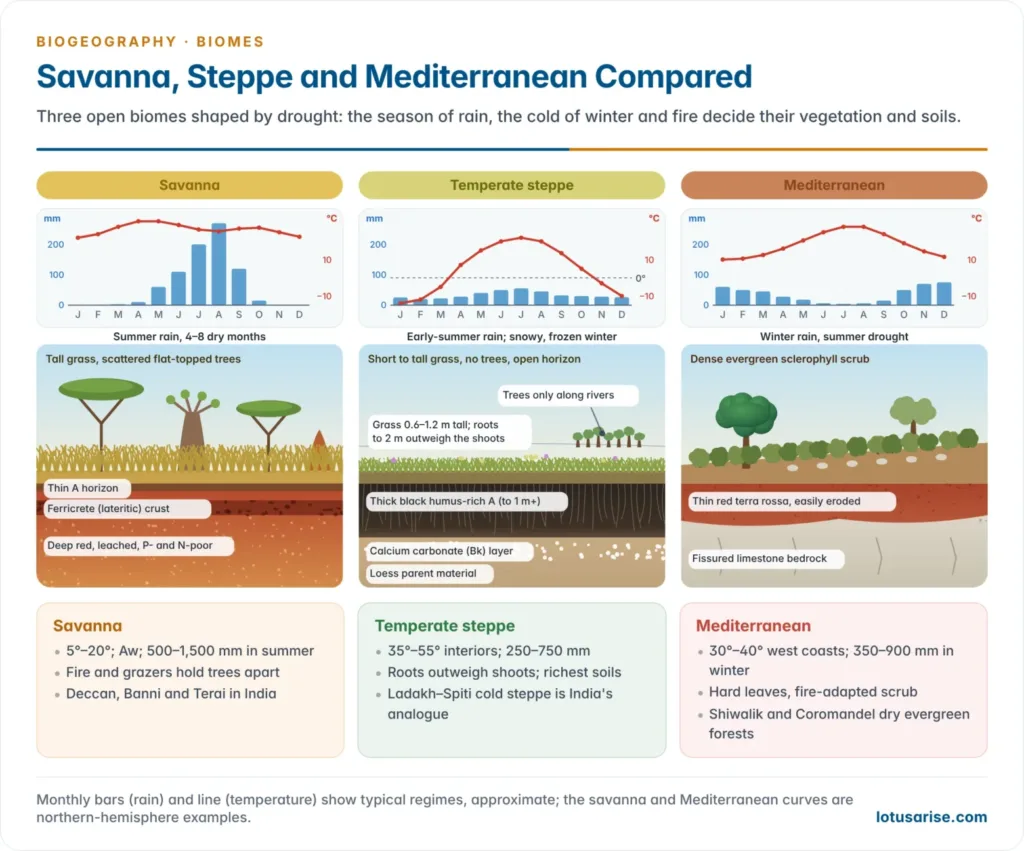
| Feature | Savanna | Temperate grassland (steppe) | Mediterranean |
|---|---|---|---|
| Latitude and position | 5°–20°, between rainforest and desert | 35°–55°, continental interiors | 30°–40°, west coasts |
| Rain season | Summer (wet–dry tropics) | Early summer; snowy winter | Winter; summer drought |
| Temperature | Warm all year | Hot summer, very cold winter | Mild winter, warm summer |
| Vegetation | Tall grass with scattered trees | Short to tall grasses, treeless | Evergreen sclerophyll scrub and woodland |
| Soils | Ferralsols, lateritic crusts | Chernozem, chestnut soils | Terra rossa, brown Mediterranean soils |
| Key animals | Large grazers and predators | Bison, saiga, burrowing rodents | Deer, rodents, reptiles, raptors |
| Human use | Pastoralism, ranching, parks | Wheat, maize, ranching | Olive, vine, citrus, cities |
| Indian analogue | Deccan and Terai savannas | Ladakh–Spiti cold steppe | Shiwalik and Coromandel dry evergreen forests |
5. Tundra Biome
- Tundra (from a Finnish word for a barren, treeless upland) is the treeless vegetation of very cold regions where conditions are too severe for trees. There are two types, arctic and alpine.
- Location:
- Arctic tundra lies between the polar ice caps and the northern limit of the boreal forest: northern Alaska and Canada, coastal Greenland, the arctic seaboard of European Russia and Siberia, and the arctic islands.
- Antarctic tundra is confined to the Antarctic Peninsula and sub-Antarctic islands; Antarctica has only two native flowering plants. Alpine tundra lies above the treeline on high mountains.
- Arctic zones (by latitude, not altitude): low arctic tundra in the south, middle arctic tundra, and high arctic tundra on the northernmost islands (the Queen Elizabeth Islands), passing into polar desert.
- Climate (Köppen ET):
- Long, severe winters with polar night and short, cool summers: summer may reach about 15 °C, winter about −57 °C. The warmest month stays below 10 °C, which keeps trees out.
- Very low precipitation, below about 250–400 mm, mostly snow, so the tundra is a cold desert. Snow lies seven to eight months, swept by blizzards.
- The growing season is generally under 50–60 days between spring and autumn frosts, so productivity is low.
- Soils: permafrost (permanently frozen subsoil) underlies arctic tundra; only a thin active layer thaws each summer.
- Meltwater cannot drain, so soils are waterlogged, gleyed and peaty (Cryosols); dry stony ground carries only lichens and mosses.
- Freeze–thaw sorts the ground into polygons, stone circles and solifluction lobes, the periglacial landforms.
- Vegetation:
- Cryophytes, adapted to cold; only a few per cent of the world’s plant species, fewer northward. Typical plants are cotton grass, sedges, dwarf heaths, dwarf willows and birches, mosses and lichens such as reindeer moss.
- Most plants are only 5–8 cm high, hugging the ground, which is warmer than the air, and sheltering under snow. They grow as cushions (moss campion), rosettes (snow saxifrage), mats (mountain avens) and tussocks.
- Long-lived and slow-growing: the arctic willow (Salix arctica) stays a few centimetres tall but can live 150–300 years. Thick cuticles and epidermal hairs protect plants from chill.
- Flowering, pollination, seed ripening and dispersal must fit into about 50 summer days, so most plants are perennials that form flower buds a year ahead.
- Fauna:
- Residents are well insulated: the musk ox (dense under-wool and long outer hair, moulted in summer), arctic fox (double fur coat, active down to about −50 °C), arctic hare, lemmings, ptarmigan, snowy owl, and the polar bear on the coast and sea ice.
- The ptarmigan, arctic fox and stoat turn white in winter. Large bodies with small ears and tails reduce heat loss. Lemmings, shrews and voles tunnel under the snow, and lemming numbers boom and crash every few years.
- Migrants: caribou and reindeer travel hundreds of kilometres between summer calving grounds on the tundra and winter shelter in the taiga; ducks, geese and swans breed in summer pools; the arctic tern winters off Antarctica, enjoying two summers a year.
- Insects (mosquitoes, midges, blackflies) have short life cycles completed in the brief summer. Their swarms feed young birds and torment caribou, which take refuge in pools and streams.
- Residents are well insulated: the musk ox (dense under-wool and long outer hair, moulted in summer), arctic fox (double fur coat, active down to about −50 °C), arctic hare, lemmings, ptarmigan, snowy owl, and the polar bear on the coast and sea ice.
- Productivity: NPP falls from about 230 g/m²/year in the low arctic to about 140 in the high arctic and 12 in polar desert. Little sunlight, poor soils, permafrost and the short season limit it; wet litter builds peat, and food scarcity makes many animals migratory.
- Human use: the Inuit of Greenland, Canada and Alaska, the Sami of Scandinavia, the Nenets of north-west Siberia, the Sakha (Yakuts) of the Lena basin and the Chukchi and Koryaks lived as nomads on fish, seals, walrus, caribou and reindeer.
- Most now live in settled or semi-nomadic communities and herd reindeer; rifles and snowmobiles have replaced harpoons and sledges, enlarging their impact on wildlife.
- The tundra also hosts oil, gas and mineral extraction (Prudhoe Bay, Yamal, Norilsk), and the Northern Sea Route is opening to shipping.
- India: alpine tundra above about 4,000–4,500 m in the Himalaya and the cold desert of Ladakh, with cushion plants, brahma kamal, the snow leopard, Himalayan marmot and bharal.
- Current threats:
- The Arctic is warming nearly four times as fast as the globe; permafrost temperatures in 2024 were the highest on record at nearly half of Alaska’s monitoring sites.
- NOAA’s Arctic Report Card 2024 found that the tundra has become a net source of carbon dioxide, and remains a methane source, as soils thaw and fires grow more frequent.
- Pipelines, roads, mines and spills (the Norilsk diesel spill of 2020) scar fragile ground that heals over decades.
6. Mountain Biome
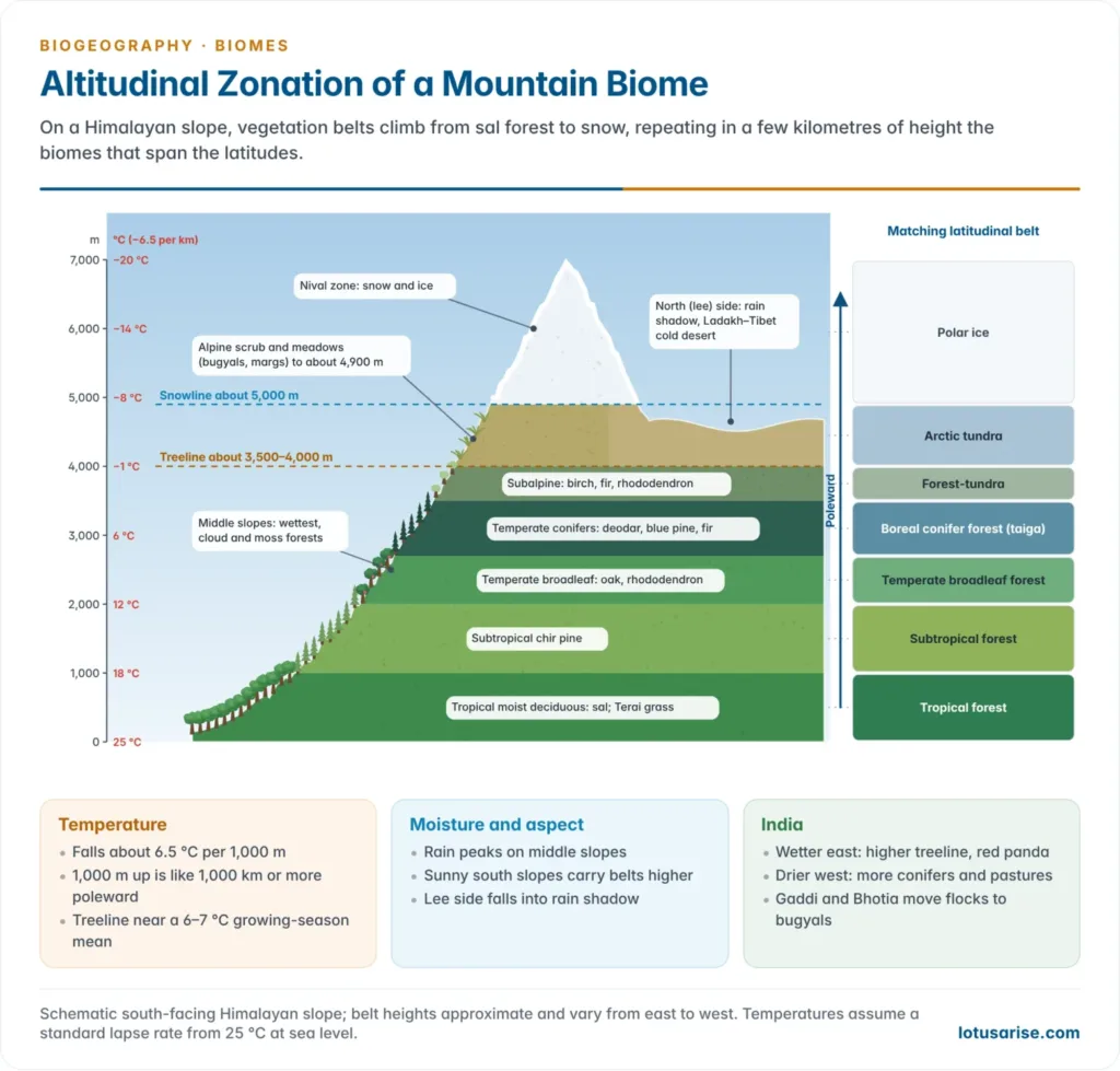
- The mountain biome is a stack of climates: on a high mountain, biomes spread over thousands of kilometres of latitude are compressed into a few thousand metres of altitude. Heinrich Walter called these belts orobiomes.
- Alexander von Humboldt and Aimé Bonpland mapped them on Chimborazo in the Andes (published 1807), the first scientific profile of vegetation zones.
- Climate–vegetation relationship:
- Temperature falls with height at an average lapse rate of about 6.5 °C per 1,000 m. Climbing 1,000 m is roughly like moving 1,000 km or more poleward, so tropical, temperate, boreal and tundra-like belts follow one another upslope.
- Precipitation rises with height through orographic uplift to a zone of maximum rainfall on middle slopes, then falls. This band carries the densest forests and cloud forests draped in mosses and epiphytes.
- Aspect: in the northern hemisphere, sunny south-facing (adret) slopes are warmer and drier than shady north-facing (ubac) slopes, so belts sit higher on the sunny side; windward slopes are wetter than leeward ones.
- Thin air, intense UV and wind favour small, hairy, dark-pigmented plants; wind shapes stunted krummholz near the treeline.
- Treeline: trees stop where the mean growing-season temperature falls to about 6–7 °C, so treelines rise from about 1,000 m in southern Scandinavia to 3,500–4,500 m in the tropics and the eastern Himalaya.
- Mass-elevation effect: large high massifs such as the Tibetan Plateau heat the air above them, so their treelines and snowlines lie higher than on isolated peaks.
- Soils thin out upslope, while temperature inversions can place cold-air belts in valleys below warmer slopes.
| Zone | Andes (tropical) | Himalaya (India, approx.) |
|---|---|---|
| Hot foothill | Tierra caliente (below about 1,000 m): rainforest, bananas, cacao | Tropical moist deciduous sal forest, Terai grassland (below 1,000 m) |
| Warm | Tierra templada (1,000–2,000 m): montane forest, coffee | Subtropical chir pine (Pinus roxburghii) forest (1,000–2,000 m) |
| Cool | Tierra fría (2,000–3,200 m): cloud forest, maize, wheat, potato | Temperate broadleaf forest of oak, rhododendron and laurels (1,500–2,500 m); conifers: deodar, blue pine, spruce, fir (2,500–3,500 m) |
| Cold | Páramo and puna (3,200–4,800 m): grasses, cushion plants, llamas | Subalpine fir, birch and rhododendron to the treeline (about 3,500–4,000 m); alpine scrub and meadows (bugyals) to about 4,800 m |
| Frozen | Tierra helada (above about 4,800 m): rock and ice | Nival zone: snow and ice above about 5,000 m |
- Eastern and western Himalayan forest belts differ: the wetter east has richer broadleaf and rhododendron forests, higher treelines and the red panda; the drier west has more conifers and dry alpine pastures, and Ladakh beyond the Great Himalaya is cold desert.
- Fauna: zoned like the plants: snow leopard, ibex, bharal, markhor, Himalayan tahr, musk deer, Himalayan monal, yaks and pikas; in the Andes the llama, alpaca, vicuña and Andean condor.
- Human use: transhumance (the Gaddi, Bakarwal and Bhotia move flocks to alpine meadows in summer), terrace farming, apple orchards, medicinal herbs, hydropower, pilgrimage and tourism.
- Current threats: elevation-dependent warming (mountains warm faster than lowlands), upslope shifts of plants and the treeline, glacier retreat, slopes destabilised by roads and dams (the Joshimath subsidence, 2023), invasive weeds and overgrazing of alpine meadows.
Terrestrial biomes at a glance
| Biome | Köppen | Rainfall (mm) | Soil | Vegetation | Indian analogue |
|---|---|---|---|---|---|
| Tropical rainforest | Af | Over 2,000 | Ferralsol, thin humus | Evergreen broadleaf, five strata | Western Ghats, North-east, Andamans |
| Tropical deciduous | Am, Aw | 1,000–2,000, seasonal | Red, laterite, black | Teak, sal, bamboo | Central India, Deccan, Shiwaliks |
| Savanna | Aw | 500–1,500 | Ferralsol, ferricrete | Grass with scattered trees | Deccan, Banni, Terai |
| Hot desert | BWh | Under 250 | Aridisol, sand, salts | Xerophytes, succulents | Thar |
| Mediterranean | Cs | 350–900, winter | Terra rossa | Sclerophyll scrub | Shiwalik dry evergreen |
| Temperate grassland | BSk, Dfa | 250–750 | Chernozem, chestnut | Grasses, no trees | Ladakh–Spiti cold steppe |
| Temperate deciduous | Cfb, Dfb | 500–1,500 | Brown earth, mull | Oak, beech, maple | Himalayan oak forests |
| Boreal (taiga) | Dfc, Dfd | 400–700 | Podzol, mor | Spruce, fir, pine, larch | Himalayan subalpine fir–birch |
| Tundra | ET | Under 400 | Cryosol, permafrost | Mosses, lichens, sedges, dwarf shrubs | Himalayan alpine zone, Ladakh |
| Mountain | H (highland) | Varies with height | Thin, immature | Altitudinal belts | Himalaya, Western Ghats sholas |
B. Aquatic Biomes
- An aquatic ecosystem is the plant and animal community of a water body. Aquatic biomes are classified by salinity into freshwater and marine, with estuaries and wetlands between them.
Freshwater ecosystems
- Water on land that is continuously cycling and low in dissolved salts is fresh water; its study is limnology.
- Lentic (still) waters: ponds, lakes, bogs and swamps.
- Lotic (running) waters: springs, mountain brooks, streams and rivers, changing downstream from cold, fast, oxygen-rich headwaters to warm, slow, silty lowland rivers.
- Physical characteristics:
- Low dissolved salts; temperature varies daily and seasonally.
- Water is densest at 4 °C: the surface of tropical lakes never falls below 4 °C, that of temperate lakes swings above and below it, and that of polar lakes never rises above it.
- In temperate regions the surface freezes but organisms survive below, insulated by floating ice.
- In summer a warm epilimnion lies over a cold hypolimnion, separated by the thermocline; temperate lakes overturn in spring and autumn, mixing oxygen and nutrients.
- Light has a great influence; suspended material blocks its penetration. Some animals rise to the surface for oxygen, and aquatic plants use dissolved carbon dioxide.
- Lakes and ponds are inland depressions holding standing water. Lake Superior is the largest freshwater lake by area and Lake Baikal in Siberia the deepest. In India, Chilika (Odisha) is the largest brackish coastal lagoon and Wular (Jammu and Kashmir) one of the largest freshwater lakes.
- Zones of a lake: the shallow littoral zone with rooted plants; the limnetic zone of open, lit water beyond it; the dark profundal zone; and the benthic zone (bottom), where decomposers work.
- Trophic status: oligotrophic lakes are deep, clear and nutrient-poor; eutrophic lakes are nutrient-rich and prone to algal blooms and oxygen loss when sewage or fertiliser enters.
- Organisms float, swim or stay fixed, according to size and habit. Microscopic floaters (algae, diatoms, protozoans, larval forms) are plankton; free swimmers are nekton; rooted plants, molluscs and other bottom dwellers are benthos.
- Wetlands are periodically inundated areas that support a flourishing aquatic community, including frogs and other amphibians: swamps, marshes, bogs and mangroves.
- Lying between aquatic and terrestrial ecosystems, they form an ecotone (a transitional zone between two ecosystems) and show an edge effect.
- They purify water, store floods, recharge groundwater and store carbon; wetlands of international importance are listed under the Ramsar Convention (1971).
Marine ecosystem
- Oceans cover about 71% of the Earth’s surface and are habitable throughout. Their living biomass is small next to land plants, but marine phytoplankton carry out about half of global photosynthesis.
- In many ways the sea is more favourable to life than land: it is more equable, oxygen and carbon dioxide are readily available (if unpolluted), and many crustal minerals are dissolved in it. Its main gradients are temperature, salinity and light.
- Salinity is highest where temperature, and hence evaporation, is highest, in the subtropics. Many marine organisms tolerate only a narrow range, which confines them to certain depths or areas. In the open oceans it ranges only from about 37‰ in the subtropics to 33‰ in polar seas.
- Temperature varies far less than on land: from about 32 °C in the warmest seas to −2 °C in the coldest, against a land range of about 90 °C. Vertical and horizontal currents even out temperature, salinity and dissolved gases and help drive the global energy budget.
- Light controls photosynthesis in the sea as on land. Surface light varies with latitude and season, and much is reflected in high latitudes and rough seas, so marine plants are confined to the euphotic (sunlit) zone, the upper 100–200 m.
- Zones: the intertidal (littoral) zone; the neritic zone over the continental shelf, to about 200 m; and the oceanic (pelagic) zone, divided by depth into epipelagic (to 200 m), mesopelagic (to 1,000 m), bathypelagic (to 4,000 m), abyssopelagic (to 6,000 m) and hadal (trenches). The floor is the benthic zone.
- Marine plants are far less diverse than land plants: algae dominate, and the few flowering plants (seagrasses) grow near shore. Seaweeds are the most visible, but about 99% of marine plant life is microscopic phytoplankton, one-celled organisms with chlorophyll such as diatoms and dinoflagellates.
- Productivity: nearshore areas also receive nutrients from rivers, so coastal and estuarine waters are among the most fertile parts of the sea, as are upwelling zones (Peru, Benguela); the open subtropical gyres are biological deserts.
- Animal life:
- The sea is richest at the higher levels of classification: almost every major animal group (phylum) occurs in the sea, and several nowhere else. Insects are almost absent, with exceptions such as the sea skater.
- Maximum diversity lies in the tidal and nearshore zone and on coral reefs.
- Free floaters: diatoms, algae, dinoflagellates and jellyfish. Free swimmers: fish, large crustaceans, squid, turtles, and mammals such as seals, porpoises, dolphins and whales. Bottom dwellers are mostly sessile (fixed) or slow: sponges, corals, crabs and starfish.
- Special marine ecosystems: estuaries (brackish, nutrient-rich fish nurseries); mangroves, salt-tolerant tidal forests with stilt roots and breathing roots (India’s mangrove cover is about 4,992 km², ISFR 2023, led by the Sundarbans); and coral reefs, the “rainforests of the sea”.
- Adaptations:
- Lightweight animals and plants float and move with the currents.
- Marine organisms tolerate high salt concentrations through osmoregulation, the process that keeps a constant osmotic pressure in the body fluids.
- Swimming animals have streamlined bodies, many laterally compressed.
- Deep-sea forms show bioluminescence (they emit light) and depend on food sinking from the upper zones; some live on chemosynthetic bacteria at hydrothermal vents.
Global Disruptions and Biome Shifts
- The distribution of biomes is not permanent. Because biomes are defined by temperature and moisture limits, any shift in global climate moves their boundaries.
- During the Pleistocene glaciations the taiga and tundra spread far south and rainforests shrank into refugia; the present pattern is only about 10,000 years old.
- Present climate change is driving biome change at an accelerating rate, on top of direct land conversion.
Poleward and upward range shifts
- As temperatures rise, species are moving toward higher latitudes and higher elevations to track their climatic niches. Meta-analyses assessed by the Intergovernmental Panel on Climate Change (IPCC) show that roughly half of the thousands of land and marine species studied have already shifted their ranges.
- The taiga–tundra shift: the boreal forest is advancing northward into tundra. Warming lengthens its growing season, but interior drought raises tree mortality and fuels catastrophic fires, as in Canada in 2023.
- The mountain squeeze: montane grasslands and shrublands expand upward into alpine meadows, and high-altitude specialists such as the American pika and alpine flora run out of higher ground. Himalayan treelines and alpine plants are moving upslope too.
- Savanna and forest edges: repeated drought and fire can push degraded rainforest toward savanna, the feared Amazon “dieback”, while CO₂ and fire suppression thicken woody cover in savannas.
Permafrost degradation and Arctic greening
- Polar amplification has warmed the Arctic nearly four times as fast as the global average since 1979, degrading permafrost widely.
- When permafrost thaws, the ground collapses (thermokarst), creating “drunken forests” where trees tilt wildly as the soil turns to mud beneath them.
- Feedback loop: thawing exposes ancient frozen organic matter to microbes, releasing carbon dioxide and methane that accelerate warming; in 2024 the tundra was reported to be a net carbon source.
- Arctic greening: taller woody shrubs colonise the warming soils, permanently altering the tundra’s low-growing vegetation; darker shrubs also absorb more sunlight than snow-covered tundra.
Marine biome collapse: coral bleaching
- The marine biome faces the dual threat of rising ocean temperatures and ocean acidification, caused by seawater absorbing excess carbon dioxide. Coral reefs are exceptionally sensitive.
- When water exceeds the local seasonal maximum by even 1–2 °C for weeks, the bond between coral polyps and their symbiotic zooxanthellae breaks down; the corals expel the algae, losing their main food source and colour: coral bleaching.
- If the heat persists, corals starve and die, the reef framework collapses, and thousands of associated species, from invertebrates to large fish, lose their habitat.
- The fourth global bleaching event (2023–2025) exposed about 84% of the world’s reef area to bleaching-level heat, the most extensive on record.
Why biomes matter
- Biomes are the ultimate expression of life’s adaptation to the physical limits of the planet, from rain-soaked equatorial canopies to frozen polar expanses. They regulate the carbon and water cycles, purify water and sustain the biodiversity on which society depends.
- Climate change and land conversion are breaking these ancient boundaries. Protecting biomes needs climate mitigation together with large protected landscapes and connected corridors that give species room to adapt and move.
Previous Year Questions
2026Explain the vertical zonation of vegetation of the Himalayas.2017Describe the characteristics of biological deserts.2016Bring out the ecological significance of Tropical Rainforest Biome.2014State the uniqueness of the Eurasian Steppe Biome.2013Bring out the relationship between climate and vegetation in the Mountain Biome.2011Define the term biome. List the terrestrial biomes and describe the characteristics of Savanna biome.2009Give a brief account of the principal land biomes and their latitudinal distribution.1996Write short note: Man, and the Amazon rainforest.





with due respect, the content is good but one thing worth mentioning is that aquatics are not biomes but ecosystems
their is no accurate defination of ecosystem, ecosystem can be small as leaves and can big as biosphere