

- Water underpins ecological security, farm growth and rural livelihoods. Yet India faces a paradox: it receives ample rain, but much of it runs off in a few monsoon weeks, bringing floods in some places and drought in others. The problem is sharpest in rainfed, semi-arid and hilly areas.
- Average annual water availability was assessed at 1,862 BCM (about 1,999 BCM on the later estimate). Of the older total, 1,123 BCM was utilisable: 690 BCM surface water and 433 BCM replenishable groundwater.
- Per capita availability fell from 6,008 cubic metres a year in 1947 to under 1,800 by 2014, and about 1,486 in 2021.
- Watershed management treats land, water, vegetation, livestock and people within one natural drainage unit, to conserve rainwater, check erosion, raise productivity and strengthen livelihoods.
- In India it grew from soil conservation works in river valley catchments into the Integrated Watershed Management Programme (IWMP, 2009–10). It has been the Watershed Development Component of the Pradhan Mantri Krishi Sinchayee Yojana (WDC-PMKSY) since 2015–16, with a second phase, WDC-PMKSY 2.0, for 2021–26.
Watershed: Concept and Delineation

What is a Watershed?
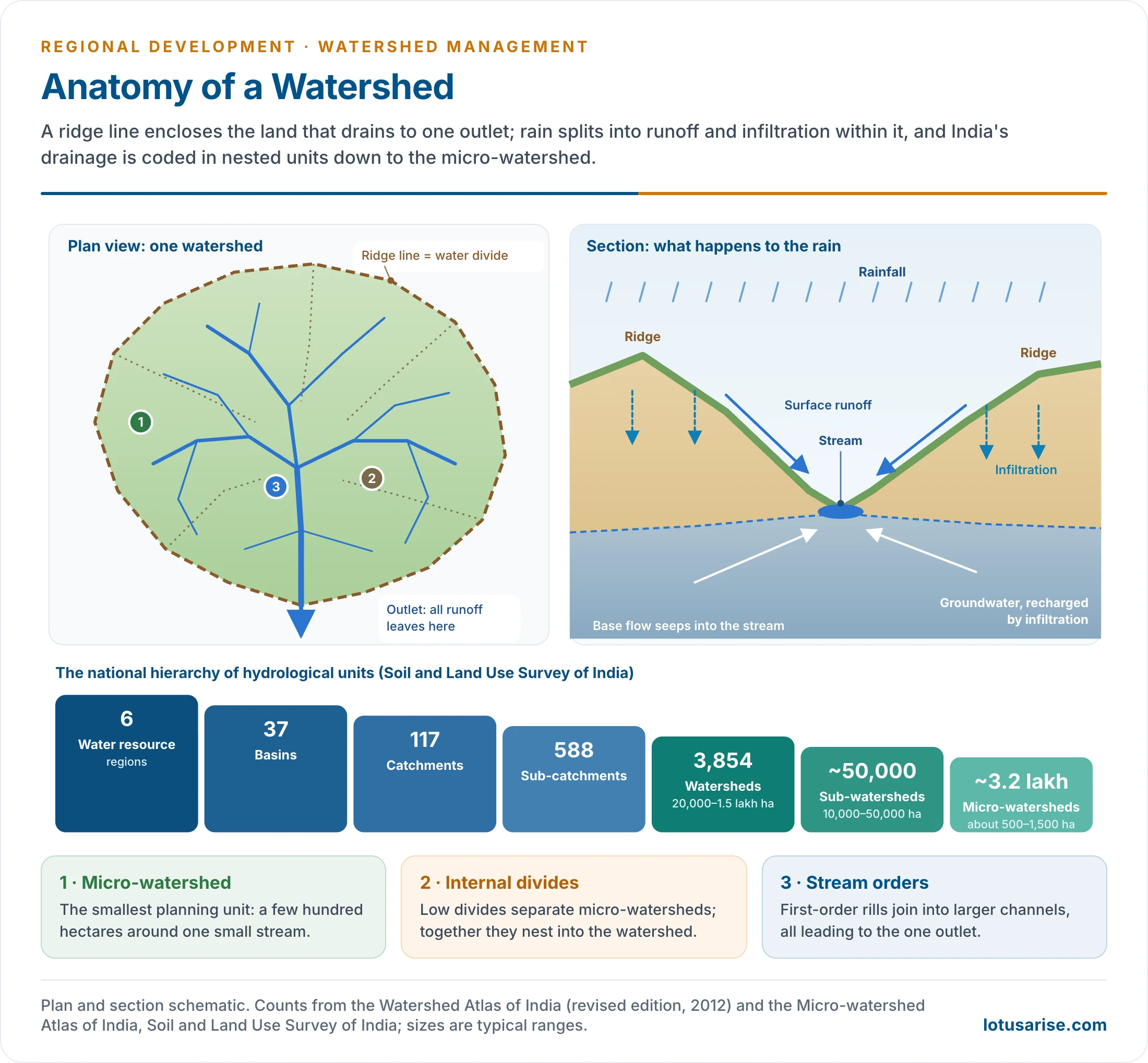
- A watershed is a geo-hydrological unit of land that drains its rainfall to a common outlet: a stream, river, lake or reservoir.
- Every drop that falls inside it flows, over or under the ground, towards the same point.
- Its boundary is the water divide (drainage divide). In hills this is a sharp ridge line; on undulating plains it can be hard to trace.
- Watersheds are nested: small watersheds join to form larger ones, up to a whole river basin. Size ranges from a few hectares to thousands of square kilometres. In broad terms they are called micro, mini and macro watersheds.
- A watershed is at once a physical, biological, economic and social system.
- Land, water and vegetation are naturally linked. If the upper catchment is degraded, the lower areas suffer from siltation, floods, poor groundwater recharge and falling farm output.
- It is bounded vertically by the zone of human activity and horizontally by the area whose water drains to one point.
- Usage differs: American usage equates watershed with catchment (the drained area), while older British usage meant the divide itself. Indian planning follows the first meaning.
Delineation and Codification
- The Soil and Land Use Survey of India (formerly the All India Soil and Land Use Survey Organisation) of the Ministry of Agriculture has built a national system of delineation and alphanumeric codification.
- The first Watershed Atlas of India (1990) divided the country into 6 water resource regions, 35 basins, 112 catchments, 500 sub-catchments and about 3,200 watersheds.
- The revised atlas (2012) and the Micro-watershed Atlas on 1:50,000 scale, prepared with digital elevation models, refined this.
| Level | Revised count | Typical size | Code |
|---|---|---|---|
| Water resource region | 6 | Whole drainage systems (Indus, Ganga, Brahmaputra, east-flowing, west-flowing, Rajasthan’s inland drainage) | Number 1–6 |
| Basin | 37 | Large river basin | Letter |
| Catchment | 117 | Major tributary system | Number |
| Sub-catchment | 588 | Part of a catchment | Letter |
| Watershed | 3,854 | About 20,000–1,50,000 ha | Number |
| Sub-watershed | About 50,000 | 10,000–50,000 ha | Letter |
| Micro-watershed | About 3.2 lakh | About 500–1,500 ha in the atlas | Number |
- For project planning, the smaller units are classed by area:
- sub-watershed: 10,000–50,000 ha;
- milli-watershed: 1,000–10,000 ha;
- micro-watershed: 100–1,000 ha;
- mini-watershed: 1–100 ha.
- Every village falls in one or more micro-watersheds. The unique code lets different departments plan in the same hydrological frame and avoid duplicating work.
- Delineation uses stream networks and drainage divides on topographical maps and digital elevation models. It starts at the outlet and follows the highest ground around the drainage area, crossing contours at right angles.
Watershed as a Spatial Unit for Planning
- A watershed becomes a practical agricultural unit in two situations: when it serves as a drainage line or for flood control, and when it is accepted as a planning unit for hydro-electric power, irrigation and drinking water.
- Why it suits planning:
- it is a natural and functional region: runoff, erosion, sediment and groundwater all move within it, so causes and effects lie inside one boundary;
- upstream–downstream links become visible: treating the ridge protects the valley;
- it fits multi-resource planning: land, water, forest, livestock and people together;
- it can be nested from micro-watershed to river basin, matching the levels of multi-level planning;
- outcomes are measurable at the outlet: runoff, silt, water table, cropped area.
- Limits:
- watershed boundaries rarely match village, panchayat or district boundaries, while budgets, data and elected bodies follow administrative units;
- a micro-watershed may cover parts of several villages, and a village may lie in several watersheds, which complicates ownership and benefit-sharing;
- it is a weak unit for non-land activities: markets, services and industry follow towns and roads;
- on flat alluvial plains and in coastal and urban areas, divides are indistinct and groundwater flow crosses them;
- benefits fall mainly to landowners, so equity needs special provisions.
- The working compromise: treat the micro-watershed as the technical unit of works and the gram panchayat as the institutional unit, with the Gram Sabha approving watershed plans and the panchayat plan carrying them.
- Projects cluster micro-watersheds of about 1,000–5,000 ha to fit a block or group of panchayats.
Watershed Approach and Village-Level Planning
- A village plan built on the watershed starts from micro-watershed maps of slope, soil, drainage, land use and wells, rather than from a list of schemes.
- The Gram Sabha sees its land as part of a drainage system:
- ridge land, often commons or forest, is treated first;
- private fields get bunds and farm ponds;
- drainage lines get check dams that serve several villages.
- Where one micro-watershed spans several villages, an inter-village watershed committee or the block panchayat coordinates works and shares water.
- The village water budget becomes the basis for crop planning, drinking-water security and the location of new wells.
- Watershed works fill the natural resource part of the Gram Panchayat Development Plan and the wage-employment shelf of works, so that labour, money and planning meet on the same map.
Watershed Management
Meaning
- Watershed management is the scientific and participatory management of land, water and biological resources within a watershed, to achieve ecological balance and sustainable development.
- It includes:
- soil and moisture conservation;
- rainwater harvesting and groundwater recharge;
- afforestation and pasture development;
- drainage line treatment;
- crop planning;
- livestock and livelihood development;
- community participation and institution building.
- It is not merely a water conservation programme but a comprehensive rural development strategy.
Principles of Watershed Management
- Use land according to its capability, as set by land capability classification: crops on good land, trees and grass on steep or shallow land.
- Conserve as much rainwater as possible where it falls (in situ conservation).
- Drain excess water at a safe velocity and divert it to storages (farm ponds, tanks) for later use.
- Prevent gully formation, and build check dams at suitable points to control erosion, store water and recharge groundwater.
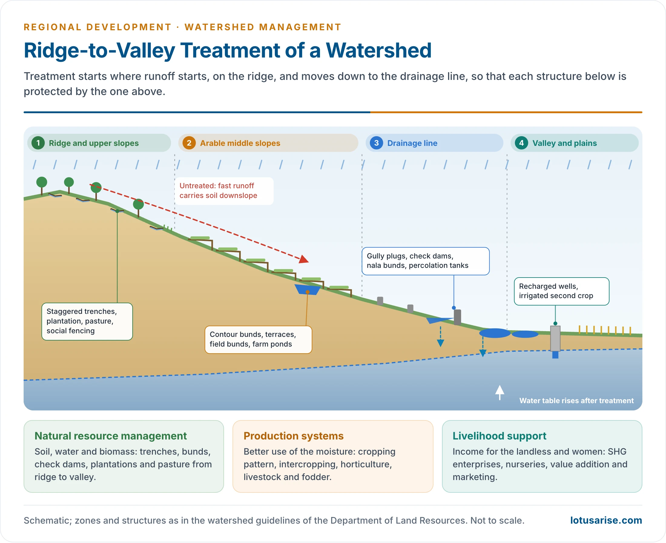
- Treat from ridge to valley: start at the top of the watershed, where runoff begins, and move down to the drainage lines.
- Choose a cropping pattern suited to the watershed, and maximise productivity per unit area, per unit time and per unit of water.
- Involve the community in planning, execution, maintenance and benefit-sharing; equity for the landless and women.
Objectives
- Conserve soil and rainwater, and harness surplus water to create water sources and recharge groundwater.
- Stabilise crop yields through suitable cropping and crop management; raise cropping intensity and the land equivalent ratio through intercropping and sequence cropping.
- Cover non-arable land with afforestation, horticulture and pasture according to land capability; use marginal and wastelands through agroforestry and alternative land uses.
- Raise and stabilise incomes, and cut the risk in aberrant weather, through alternative enterprises.
- Restore ecological balance in the man–animal–plant–land–water complex of the watershed.
- Improve infrastructure for storage, transport and marketing.
The Three-Pronged Approach
- Modern watershed programmes rest on three linked components:
- natural resource management: soil, water and biomass;
- production systems: area, cropping pattern, productivity, livestock;
- livelihood support: income generation, enterprises and marketing, especially for the landless.
- The first builds the resource base, the second uses it, and the third spreads the gains to people who own no land in the watershed.
Major Activities
- Physical works, by zone:
- ridge and upper slopes: staggered contour trenches, continuous contour trenches, vegetative barriers, afforestation, pasture and social fencing against grazing;
- middle slopes and arable land: contour and graded bunds, terraces (bench terraces in the hills), field bunds, land levelling, farm ponds;
- drainage lines: gully plugs, loose-boulder and gabion check dams, nala bunds, percolation tanks and sub-surface dykes;
- valley and plains: recharge of wells, tanks and ponds, and community storages.
- Production activities: improved cropping, intercropping, horticulture, sericulture, dairy, fisheries, poultry, goat rearing and organic farming.
- Livelihood activities: nurseries, cottage industries, value addition, micro-enterprises and support for asset-less households.
Planning for Watershed Management
Planning Steps
- Selection and prioritisation: watersheds are ranked on rainfall, erosion, degradation, groundwater stress, poverty and the share of SC/ST population, using remote sensing and census data.
- Preparatory phase:
- entry point activities build trust: a drinking-water source or repaired tank, chosen by the village;
- participatory rural appraisal (PRA): resource mapping, transect walks, seasonal calendars and wealth ranking;
- formation of the watershed committee, user groups and self-help groups.
- Resource inventory and the detailed project report (DPR):
- maps of soils, slope, land use, drainage, groundwater and erosion from satellite data, digital elevation models and field survey;
- treatments decided on a ridge-to-valley plan, by land capability;
- a water budget: rain received, runoff, storage, recharge and safe use.
- Works phase: soil and water conservation, drainage line treatment, plantations, production systems and livelihoods, with monitoring.
- Consolidation and withdrawal: handover of assets to the watershed committee, user groups and gram panchayat; a watershed development fund from user contributions pays for upkeep.
Remote Sensing and GIS
- Comprehensive planning starts with maps from remote sensing.
- Satellite imagery gives a synoptic view of the watershed: its land, water and vegetation and the links between them.
- It estimates the area and yield of major crops, the spread of pests, disease and drought, and the status of resources.
- It helps locate check dams and farm ponds.
- Mechanical, agronomic, agro-ecological and forestry measures are then planned together.
- The SRISHTI geo-portal (2015), built with the National Remote Sensing Centre, monitors WDC projects. Field staff upload geo-tagged, time-stamped photographs of each work through a mobile application; about 23 lakh works have been geo-tagged.
Institutions under IWMP and WDC-PMKSY
- State Level Nodal Agency: sanctions projects and oversees the programme in the State.
- Watershed Cell-cum-Data Centre: at the district.
- Project Implementing Agency (PIA): a line department, NGO or other agency for each project.
- Watershed Development Team: technical experts supporting the PIA.
- Watershed Committee: at the village level, set up by the Gram Sabha, with user groups and SHGs under it.
Case Study: Watershed Planning Ignored in Gurugram
- In July 2016 two hours of heavy rain paralysed Gurugram with deep waterlogging and traffic gridlock. The root cause was planning that ignored the watershed.
- The city lies between the Firozpur Jhirka–Delhi ridge on the west and the Delhi ridge on the east. Its natural drainage was a set of depressions and seasonal streams that collected water inland rather than draining to the Yamuna.
- The Delhi–Jaipur highway (old NH-8) crosses several of these watersheds near their middle and blocks the natural south-to-north drainage. Built-up areas covered the depressions and streams.
- The lesson: urban and infrastructure planning must follow drainage lines and watershed boundaries, just as rural planning does.
- The same lesson recurs elsewhere:
- Chennai (2015), where encroached lakes, wetlands and the Pallikaranai marsh could no longer hold flood water;
- Bengaluru (2022), whose linked chains of tanks and connecting storm channels had been built over.
- Cities built on old tank cascades flood when the cascade is broken.
Significance
- Agriculture: more soil moisture and protective irrigation, a second crop and higher, steadier yields in rainfed farming.
- Water: floods are moderated, tanks and reservoirs silt up less, wells are recharged, and crops get rainwater, which mitigates drought.
- Soil: erosion is checked and degraded land is restored.
- Livelihoods and poverty:
- wage work during construction;
- more crops, fodder, milk and fuelwood afterwards;
- social forestry and cottage industry incomes;
- less distress migration;
- tribal and dryland villages escape the drought–debt cycle.
- Hilly regions: on steep Himalayan and Western Ghats slopes, terracing, contour trenches, spring and springshed recharge, check dams and plantations protect soil, revive springs and reduce landslides and flash floods.
- Ecology: more vegetation and biodiversity, and a landscape kept healthy and sustainable.
Evidence of Impact
- A comprehensive assessment of Indian watershed programmes by the International Crops Research Institute for the Semi-Arid Tropics (ICRISAT), drawing on hundreds of project studies, reported:
- soil loss reduced by about 1.1 tonnes per hectare a year;
- additional water storage of about 38 hectare-metres in a 9,500 ha watershed;
- irrigated area up by about 52% and cropping intensity by about 35.5% in treated watersheds;
- higher returns in low-income regions and in areas of 700–1,000 mm annual rainfall;
- better results where people participated;
- larger watersheds (over 1,000 ha) doing better than very small ones (below 500 ha).
- Third-party end-line evaluations of completed WDC-PMKSY projects report higher water tables, yields, vegetative cover and household incomes.
Watershed Management in Hilly Regions
- Steep slopes, thin soils, intense monsoon rain and deforestation make the Himalaya, the North-Eastern hills and the Western Ghats the most erodible terrain. The gains of treatment are correspondingly large.
- Measures:
- bench terraces and stone risers on cultivated slopes;
- contour trenches and plantations on upper slopes;
- gully plugs and gabion check dams on torrents;
- landslide stabilisation with bio-engineering;
- agroforestry and horticulture in place of shifting cultivation.
- Springshed management: many Himalayan springs, the main drinking-water source of hill villages, have dried or turned seasonal.
- Mapping the recharge area of each spring through hydrogeology, then trenching and planting there, revives flows. Sikkim’s Dhara Vikas programme is the best-known example.
- WDC-PMKSY 2.0 added springshed rejuvenation as an activity.
- Problems:
- small terraced holdings;
- high cost and difficult access;
- out-migration of working-age men;
- community land tenure in the North-East;
- the need to combine watershed work with forest management and disaster risk reduction.
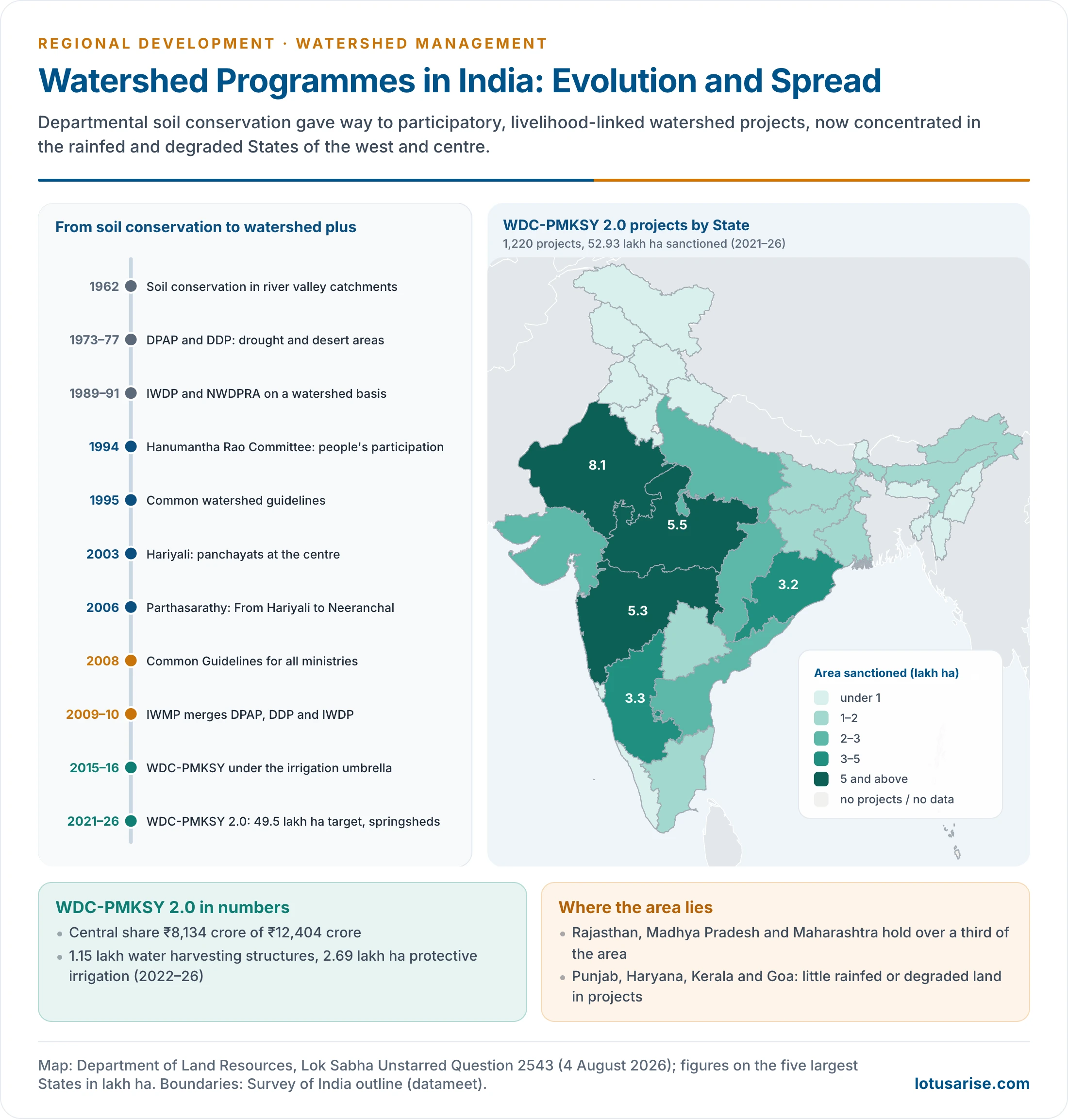
Evolution of Watershed Programmes in India
From Soil Conservation to Participation
- Early phase: soil conservation, flood control and protection of farmland.
- A centrally sponsored scheme of soil conservation in the catchments of river valley projects began in 1962.
- Works such as contour bunds, terraces, check dams, gully plugs and afforestation were engineering-led and departmental, with little community role.
- Area programmes:
- the Drought Prone Areas Programme (1973–74);
- the Desert Development Programme (1977–78), for hot and cold deserts.
- Both recognised that land degradation, water scarcity and poverty are linked, and both moved to a watershed basis from the late 1980s.
- The Integrated Wastelands Development Programme (1989) of the National Wastelands Development Board did the same.
- Rainfed farming: the Indian Council of Agricultural Research ran 47 model watersheds from the early 1980s. The National Watershed Development Project for Rainfed Areas (NWDPRA) of the Agriculture Ministry followed in 1990–91, at the close of the Seventh Plan period.
- It aimed to conserve rainwater, improve soil moisture, raise biomass and restore ecological balance: a shift from drought relief to sustainable rainfed farming.
- Participatory turn:
- The C. H. Hanumantha Rao Committee (1994) criticised the departmental, engineering-only approach. It called for the involvement of local communities, panchayats, NGOs, SHGs and user groups.
- The 1995 guidelines brought DPAP, DDP and IWDP under a common participatory approach.
- Hariyali Guidelines (2003): gave panchayats the central role in planning, implementation and monitoring.
- Parthasarathy Committee (2006): the Technical Committee on Watershed Programmes, chaired by S. Parthasarathy, reported as From Hariyali to Neeranchal.
- It reviewed government, NGO and donor programmes and urged a shift from a purely structural focus to livelihoods, with a national authority for rainfed areas.
- The National Rainfed Area Authority was set up in 2006–07.
- Common Guidelines (2008): one set of rules for watershed projects of all ministries, revised later.
Integrated Watershed Management Programme (2009–10)
- IWMP merged DPAP, DDP and IWDP into one programme of the Department of Land Resources, under the Common Guidelines 2008.
- Features:
- clusters of micro-watersheds of about 1,000–5,000 ha treated as one project;
- a project period of 4–7 years in three phases: preparatory, works, and consolidation and withdrawal;
- unit cost raised from ₹6,000 to ₹12,000 per ha in the plains and ₹15,000 in hilly and difficult areas;
- central funding of 90%;
- scientific planning with remote sensing; equity, gender sensitivity, decentralisation and post-project sustainability.
| Budget head (revised Common Guidelines) | Share of project cost |
|---|---|
| Administrative costs | 10% |
| Monitoring and evaluation | 1% + 1% |
| Preparatory phase: entry point activities, institution and capacity building, DPR | 4% + 5% + 1% |
| Watershed development works | 56% |
| Livelihoods for asset-less persons | 9% |
| Production systems and micro-enterprises | 10% |
| Consolidation phase | 3% |
- Under the first phase (IWMP, then WDC-PMKSY 1.0, 2009–22), the Department supported 6,382 projects. They created or revived 7.65 lakh water harvesting structures, brought 16.41 lakh ha under protective irrigation and benefited about 36 lakh farmers.
- Weaknesses seen in the IWMP phase:
- long delays in preparing DPRs and releasing funds, so many projects overran their period;
- weak project implementing agencies and thin technical teams;
- livelihood funds spread too thinly to change incomes;
- watershed committees that faded once the project closed.
- The shorter project period, higher unit costs and geo-tagged monitoring of WDC 2.0 respond to these lessons.
WDC-PMKSY and WDC-PMKSY 2.0
- In 2015–16 IWMP became the Watershed Development Component of PMKSY, which serves the goals of Har Khet Ko Pani and Per Drop More Crop. Its funding became 60:40, and 90:10 for hilly and North-Eastern States.
- Activities: ridge area treatment, drainage line treatment, soil and moisture conservation, rainwater harvesting, nurseries, afforestation, horticulture, pasture and livelihoods for asset-less persons.
- WDC-PMKSY 2.0 was approved on 15 December 2021 for 2021–22 to 2025–26:
- a physical target of 49.5 lakh ha;
- an outlay of ₹12,404 crore, of which ₹8,134 crore is the central share;
- unit costs raised to ₹22,000 per ha in the plains and ₹28,000 per ha in hilly, difficult and left-wing extremism areas;
- a shorter project period of 3–5 years;
- springshed rejuvenation added on NITI Aayog’s advice;
- treatment on a saturation basis through convergence with other schemes;
- GIS and remote sensing for planning;
- a new-generation focus on climate resilience, rainfed productivity, livelihood security, community institutions, digital monitoring and convergence.
- Progress (August 2026):
- 1,220 projects sanctioned over 52.93 lakh ha, above the target, in 28 States and the UTs of Jammu and Kashmir and Ladakh, at a cost of ₹12,973 crore;
- in 2022–26, 1.15 lakh water harvesting structures created or revived, 2.69 lakh ha brought under protective irrigation and 23.29 lakh farmers benefited;
- in April–September 2025 alone, 17,237 water harvesting structures created or revived, 35,882 ha brought under protective irrigation, 4.86 lakh farmers benefited and 13,953 ha under plantation or horticulture;
- in January 2025, 56 additional projects worth ₹700 crore were sanctioned for 10 best-performing States, and sanctioned projects are still being completed.
- Neeranchal National Watershed Project: a World Bank-assisted project approved in 2014, to strengthen the institutions and technical support of the watershed programme in nine States: Andhra Pradesh, Chhattisgarh, Gujarat, Jharkhand, Madhya Pradesh, Maharashtra, Odisha, Rajasthan and Telangana.
- Aims: institutional change in watershed and rainfed management; better focused and coordinated programmes with quantifiable results; sustainability after project support ends; and, through a watershed plus approach, better equity, livelihoods and incomes through forward linkages.
- Disbursement was negligible. The project was suspended in 2019, and the undisbursed credit was cancelled in July 2019. Its ideas survive in the scientific-planning features of WDC 2.0.
Village Successes
- Sukhomajri (Panchkula district, Haryana, Siwalik foothills):
- From the mid-1970s, grazing and fuelwood cutting on the bare Siwalik hills were silting Sukhna Lake in Chandigarh.
- Scientists of the Central Soil and Water Conservation Research and Training Institute built small earthen dams with the villagers. Their water irrigated fields, so villagers agreed to stop grazing the hills (social fencing).
- Fodder grass and tree cover returned and siltation fell. Water was shared by all households, landless included, through a water users’ society, later a Hill Resource Management Society.
- Scaling up across the Shivaliks in the 1990s was less successful, because dams silted where institutions were weak.
- Ralegan Siddhi (Ahmednagar district, Maharashtra):
- From 1975, under Anna Hazare, the drought-prone village built nala bunds, percolation tanks, check dams and contour trenches. Social rules followed: shramdaan (voluntary labour) and bans on free grazing, tree felling and liquor.
- Groundwater and cropping rose sharply and the village became a model of community watershed work.
- Later, unchecked borewells and water-hungry crops lowered the water table again, and the village needed tankers in the drought of 2016. Recharge without demand management is not enough.
- Hiware Bazar (Ahmednagar district, Maharashtra):
- Under sarpanch Popatrao Pawar (from 1989), the gram sabha used the State employment guarantee scheme to build trenches, bunds and plantations.
- It then regulated demand:
- a ban on borewells for irrigation (1993–94);
- a ban on water-guzzling sugarcane and bananas;
- village water budgeting from 2002–04, matching each season’s crops to the rain received, using rain gauges and observation wells.
- Its groundwater has stayed high even in drought years. Incomes rose and migration reversed.
- Jhabua (Madhya Pradesh): under the State’s Rajiv Gandhi Mission for Watershed Management (1994), tribal villages treated degraded hills and revived tanks, among the earliest large-scale participatory watershed programmes.
Traditional Watershed Wisdom
- Indian communities managed water by watershed long before the term entered planning:
- tank cascades (eris) of Tamil Nadu and Karnataka, where each tank’s surplus feeds the next one downstream;
- johads (earthen check dams) of Alwar, Rajasthan. Their revival by the voluntary group Tarun Bharat Sangh from the mid-1980s helped the Arvari river flow again;
- khadins of Jaisalmer: runoff from rocky uplands is held behind an earthen bund and the moist bed is cropped;
- kuhls of Himachal Pradesh and zabo of Nagaland, which combine forest, water storage, paddy and livestock in one slope system;
- bamboo drip irrigation in Meghalaya.
- These systems rest on community rules for upkeep and sharing, the element that modern programmes find hardest to build.
- National campaigns now draw on them: the Jal Shakti Abhiyan (2019; “Catch the Rain” from 2021) and Mission Amrit Sarovar (2022), which builds or revives ponds in every district.
State and District Initiatives
| Initiative | Place | Approach | Result |
|---|---|---|---|
| Kuan Talab Jiao Abhiyan | Jakhni, Banda district, Uttar Pradesh (Bundelkhand) | Community revival of wells and ponds, field bunds | Year-round water in a drought belt; recognised as a model jal gram |
| Mazhapolima (2009) | Thrissur district, Keralam (Kerala) | Rooftop rainwater led into open wells, by the district administration with panchayats, NGOs, community bodies and technical agencies | Thousands of low-cost well recharges; household water security, above all in summer |
| Pani Panchayats (Act 2002) | Odisha, e.g. Sunei project, Mayurbhanj | Farmers’ bodies distribute and maintain irrigation water, with seats for women | Fairer head–tail sharing even in dry years; better coordination, crop productivity and ownership of works |
| Mission Kakatiya (2015) | Telangana | Desilting and repair of thousands of minor irrigation tanks, feeder channels, bunds and field channels | Larger storage, recharge, stabilised tank commands, higher farm output and revival of tank irrigation |
| Meri Chhat Mera Pani | Chitrakoot district, Uttar Pradesh | Rooftop harvesting on public buildings, soak pits, check dams | Recharge in an aspirational, water-scarce district |
- These initiatives show that water security comes from decentralised, village-level action as well as from large dams and canals.
Challenges and Way Forward
Key Challenges
- Scale of land degradation: the ISRO Desertification and Land Degradation Atlas of India (2021) found about 97.85 million ha, or 29.77% of the country, degraded in 2018–19. Water erosion was the largest process, at 11.01% of the area.
- Rainfed dependence: net irrigated area was about 56.4% of net sown area in 2023–24, so about 43–44% is still unirrigated (an older reckoning put about 60% of cultivated area as rainfed). Crops, fodder and incomes there follow the monsoon.
- Watershed development matters most in rainfed, hilly, tribal, drought-prone and degraded regions.
- Groundwater stress: the Dynamic Ground Water Resources Assessment 2025 put annual recharge at 448.52 BCM, extractable resources at 407.75 BCM and extraction at 247.22 BCM, a stage of extraction of 60.63%.
- 730 of 6,762 assessment units (10.8%) are over-exploited, 201 critical and 758 semi-critical, concentrated in Punjab, Haryana, Rajasthan and Delhi, and in parts of Karnataka, Tamil Nadu, Uttar Pradesh and Madhya Pradesh.
- The 2024 assessment gave recharge of 446.90 BCM, extractable resources of 406.19 BCM, extraction of 245.64 BCM and a stage of 60.47%, with 751 units (11.1%) over-exploited, 206 critical and 711 semi-critical.
- Recharge structures must be paired with demand-side measures: crop choice, micro-irrigation and water budgeting.
- Weak participation: where projects run as departmental works, people stay passive beneficiaries. Check dams, ponds, bunds and plantations then decay after the project ends.
- Inequitable benefits: watershed gains are land-based. Owners of land near recharge gain most; the landless, women and herders who lose grazing commons gain least, unless livelihood components are protected.
- Poor convergence: agriculture, rural development, forests, water resources, livestock, panchayats and livelihood missions still work in silos. Structures without horticulture, micro-irrigation, credit and markets yield limited gains.
- Climate change: more intense rain causes runoff, erosion and flash floods, and longer dry spells drain soil moisture. Designs must use local rainfall trends, groundwater data and risk maps.
- Measuring outcomes: reporting still counts structures and money spent more than water tables, yields and incomes.
- Institutional sustainability: watershed committees and user groups are project bodies. Unless they are absorbed into gram panchayat standing committees or registered water user bodies, no one owns the assets after withdrawal.
- Boundary mismatch: micro-watersheds cut across villages and forest compartments, which complicates permissions, especially on forest land in the upper catchment.
Way Forward
- Ridge-to-valley treatment on a saturation basis, by land capability, with the upper slopes treated first.
- Strengthen WDC-PMKSY: report outcomes (groundwater rise, productivity, income, drought resilience and vegetation) and not only structures and spending.
- Science plus community knowledge: remote sensing, GIS, drones and aquifer maps, combined with PRA. Villagers know the seasonal streams, degraded commons, old tanks, grazing pressure and water conflicts.
- Watershed plus livelihoods: horticulture, agroforestry, dairy, fisheries, poultry, goat rearing, bee-keeping, minor forest produce and small enterprises. Landless households, women, SC/ST communities and marginal farmers should be central to benefit-sharing through watershed committees, SHGs and user groups.
- Water budgeting and crop diversification: every watershed should know how much rain it receives, stores, recharges and can safely use. Millets, pulses, oilseeds, horticulture and agroforestry should replace water-intensive crops in stressed areas.
- Post-project maintenance: a watershed development fund and clear maintenance rules for watershed committees, panchayats and user groups. Without upkeep, the programme becomes asset creation, not resource management.
- Convergence:
- rural employment works for labour-intensive soil and water conservation;
- PMKSY for irrigation and water-use efficiency;
- DAY-NRLM for SHGs and livelihoods;
- FPO schemes for markets;
- the National Mission for Sustainable Agriculture for climate-resilient farming;
- the Jal Shakti Abhiyan for water conservation;
- CAMPA and the Green India Mission for afforestation.
- Plan through the panchayat: make the watershed plan part of the Gram Panchayat Development Plan, so that the hydrological unit and the elected local body work as one.
- Watershed management is ultimately about rebuilding the relationship between land, water, people and livelihoods: from a structure-building approach to an ecosystem-and-livelihood approach.
Previous Year Questions
2025“Watershed is the most appropriate spatial unit for planning.” Comment.2021Discuss the role of watershed management for soil and water conservation in hilly regions of India.2021Stream basins and drainage divides are important components to delineate a watershed area. Explain.2019Discuss how watershed management has become a tool in eradication of rural poverty in India.2015Discuss the relationship of watershed approach to village level planning.2012Answer the following: Salient features of watershed planning and its advantages and disadvantages.2001Explain the concept of watershed and its utility in land management.1999Discuss the relevance of ‘watershed’, as an ecosystem for the purpose of sustainable development.





nicely explained
thanks
Great Work Lotus Arise Team
Very good 🙂😊 water is important so water seeds are good.
Good information
👍 good