

- Multi-level planning distributes the functions of planning across territorial and administrative levels: the Centre, the State, the district, the block, the municipality and the village.
- Its core idea: national priorities need local translation, and local needs need higher-level support. Each level plans what it can plan best, and the levels are knitted into one system.
- In India it rests on a constitutional base, the 73rd and 74th Amendments (1992). Its working instruments are the District Planning Committee and the Gram Panchayat Development Plan. Its best-known experiment is Kerala’s People’s Plan Campaign (1996).
- Panchayati Raj institutions (PRIs), with nearly half their elected members women, have also become one of the largest arenas of women’s political participation in the world.
Concept of Multi-Level Planning

Single-Level and Multi-Level Planning
- Single-level planning: plans are formulated and decisions taken at the national level. The process is centralised, and lower territorial levels appear only at the implementation stage.
- Multi-level planning: the national territory is divided into smaller territorial units, their number depending on the country’s size and its administrative, geographical and cultural setting. Each level takes part in data collection, plan formulation, implementation and monitoring.
- It has been defined as planning for a variety of regions which together form a system and subordinate systems:
- lower-level plans provide the base for higher-level plans;
- higher-level plans provide the framework for lower-level plans;
- people participate directly at the lowest levels;
- every unit is treated as a system, which makes planning more effective.
- India recognises five stages, which also mark five phases of change in planning policy:
- national: sectoral with inter-State and inter-regional planning;
- State: sectoral with inter-district and inter-regional planning;
- district or metropolitan: regional planning;
- block: village planning;
- panchayat level.
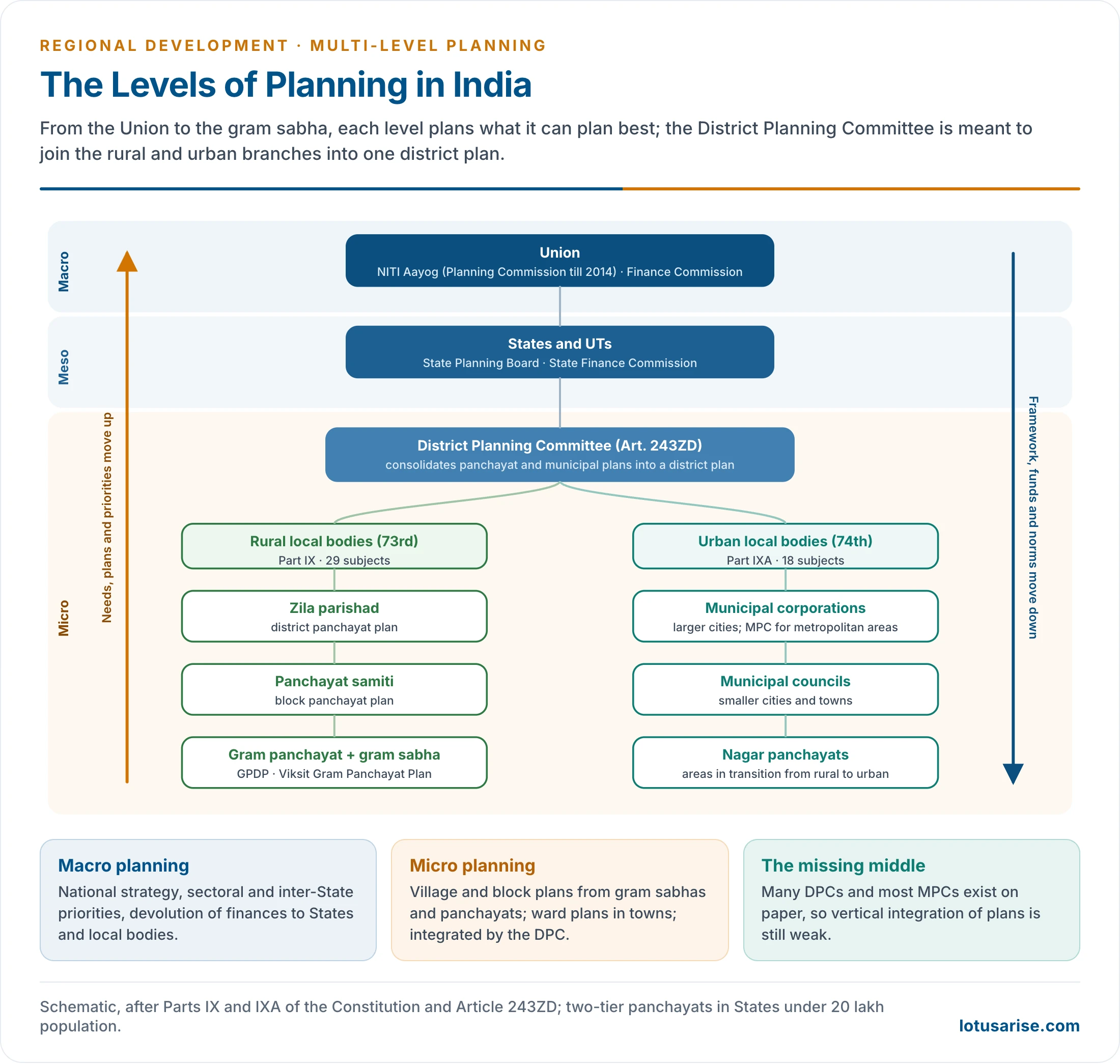
- It suits a hierarchy of planning regions: macro (nation, State or macro-region), meso (district, metropolitan region, river basin) and micro (block, cluster, village, watershed).
Decentralised Planning and Multi-Level Planning
- Decentralised planning: the functions of formulating, adopting, executing and supervising plans are distributed among regional and local bodies instead of resting with one central authority. It is planning from below.
- Multi-level planning gives it operational shape: it decides which level should plan what and how the plans fit together.
- Defence, foreign trade, railways and national highways need national planning.
- Rural roads, drinking water, local markets, primary schools, health sub-centres and village livelihoods need district, block or village planning.
- Decentralisation has three forms:
- deconcentration: field offices of government get more power;
- delegation: agencies act for government;
- devolution: elected local governments get functions, funds and functionaries.
- Only devolution makes planning genuinely democratic.
Need for Multi-Level Planning in India
- Size and diversity: one central model cannot capture the needs of Rajasthan’s deserts, Keralam’s coastal villages, Himalayan settlements, the tribal plateaus of central India and metropolitan regions such as Mumbai or Delhi.
- Regional variation in resources, climate, ecology, poverty, employment and infrastructure.
- Democratic demand for people’s participation, and better targeting of beneficiaries.
- Efficiency: less information cost, fewer delays and less red tape; better implementation and monitoring.
- Use of local resources and local knowledge; integration of rural and urban development.
- Localising the Sustainable Development Goals at the panchayat level.
Evolution of Multi-Level Planning in India
From Centralised Planning to Decentralisation
- Before Independence: panchayats are an old tradition. The British recognised them as local administrative units, and strengthened them partly to blunt national demands. Mahatma Gandhi held that India lives in its villages. About a third of villages had panchayats in 1947.
- Early plans (1951–66): planning was centralised through the Planning Commission (1950) and the Five-Year Plans, for national integration, industrialisation and resource mobilisation. The Second and Third Plans saw the need for district, block and village plans, but capacity was weak.
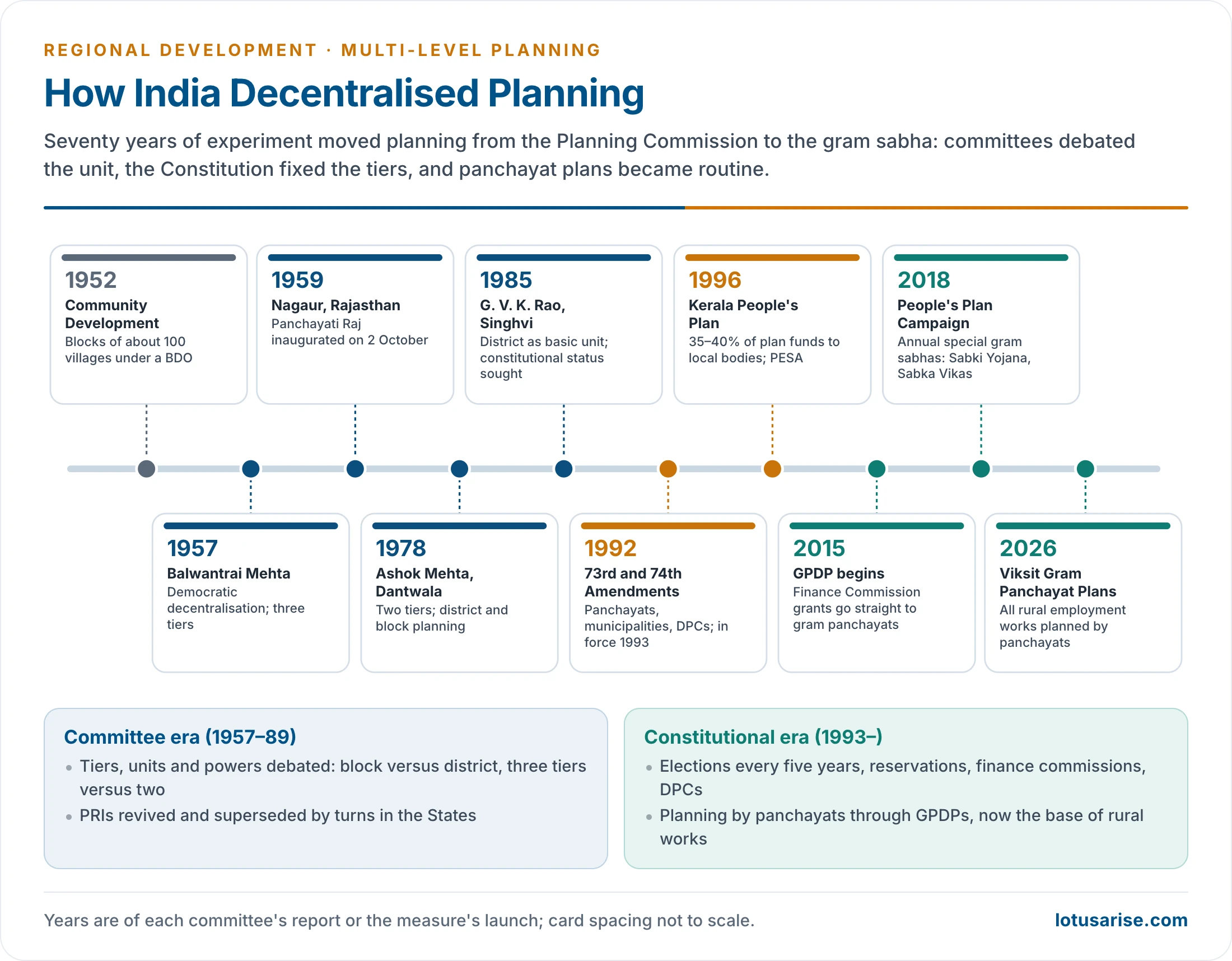
- The Community Development Programme (1952) created development blocks of about 100 villages and 60,000 people under a Block Development Officer. It was the first unit of planning below the district. Block Advisory Committees, later Block Development Committees, did not bring people in.
- Balwantrai Mehta Committee (1957): found community development failing for want of people’s participation. It recommended democratic decentralisation:
- a three-tier Panchayati Raj: gram panchayat, panchayat samiti and zila parishad, with the block as the key unit;
- well-defined rights and duties for each tier, with sufficient resources, and social and economic programmes to run through them;
- the National Development Council accepted it in 1958;
- Rajasthan inaugurated Panchayati Raj in Nagaur on 2 October 1959, followed by Andhra Pradesh, Maharashtra and Gujarat.
- Patterns varied: some States had three tiers, some two (village and block), and some only one.
- Early gains: Andhra Pradesh in education and health; Rajasthan in early development work; Tamil Nadu in education, water supply, roads and nutrition; Maharashtra and Gujarat in decentralised planning. Villagers lost their fear of officials and could approach the Block Development Officer directly.
- Third Plan (1961–66) and the Administrative Reforms Commission (1967) stressed district planning. The Planning Commission issued guidelines for district plans in 1969.
- Fourth and Fifth Plans: special area and target-group programmes (integrated rural development, drought-prone and hill areas) made the district and block the units of delivery.
- Maharashtra set up District Planning and Development Councils from 1972, and Gujarat followed with district planning boards (1979), giving districts a share of State plan funds. A Minister of State chaired these bodies.
- Ashok Mehta Committee (1977–78): set up in December 1977 with 14 members, it reported in August 1978 with about 132 recommendations. It found PRIs weakened, but held that they could be strong instruments of development through participation. It recommended:
- a two-tier system of zila parishad and mandal panchayat (a group of villages), with the district as the first point of decentralisation below the State;
- compulsory taxation powers for PRIs, with taxes such as entertainment tax and special land and building taxes passed to them;
- open participation of political parties;
- regular elections and social audit, by a district agency and a committee of legislators, of funds for weaker sections;
- a committee of the State legislature on Panchayati Raj, with Scheduled Caste and Scheduled Tribe members;
- no supersession on partisan grounds, with elections within six months of any supersession;
- urban amenities in rural areas to reduce migration.
- M. L. Dantwala Working Group (1978): made the block the unit of planning for employment, minor irrigation, soil conservation and local infrastructure. The Sixth Plan (1980–85) took up block-level planning.
- C. H. Hanumantha Rao Working Group (1984) on district planning, and the G. V. K. Rao Committee (1985): made the district the basic unit of planning and wanted PRIs revived to plan and run rural development.
- L. M. Singhvi Committee (1986): sought constitutional recognition of local self-government and a central place for the gram sabha. The 64th Amendment Bill (1989) failed in the Rajya Sabha.
- 73rd and 74th Amendments (1992): passed in December 1992. They came into force on 24 April 1993 (Panchayats, Part IX) and 1 June 1993 (Municipalities, Part IXA).
- PESA (1996) extended Part IX to the Fifth Schedule areas, giving the gram sabha special powers over land, minor forest produce and local plans in tribal areas.
| Committee | Year | Key recommendation | Unit stressed |
|---|---|---|---|
| Balwantrai Mehta | 1957 | Three-tier Panchayati Raj; democratic decentralisation | Block (panchayat samiti) |
| Ashok Mehta | 1977–78 | Two tiers: zila parishad and mandal panchayat; taxation powers; party participation | District |
| M. L. Dantwala | 1978 | Block-level planning for employment and local resources | Block |
| C. H. Hanumantha Rao | 1984 | Decentralised district planning | District |
| G. V. K. Rao | 1985 | PRIs to plan and run rural development; district as basic unit | District |
| L. M. Singhvi | 1986 | Constitutional status for local self-government; gram sabha | Village and district |
Constitutional Basis
- Article 40 (Directive Principles) asks the State to organise village panchayats as units of self-government.
- 73rd Amendment (Part IX, Articles 243 to 243O):
- gram sabha of all voters of the village (Article 243A);
- three tiers of panchayats, with two tiers in States of under 20 lakh population (243B);
- direct elections every five years through a State Election Commission (243E, 243K);
- reservation of seats and chairpersons’ posts for SC and ST in proportion to population, and not less than one-third for women (243D);
- a State Finance Commission every five years to review panchayat finances (243I).
- Article 243G lets States endow panchayats with powers to prepare and implement plans for economic development and social justice, including the 29 subjects of the Eleventh Schedule: agriculture, minor irrigation, watershed development, rural housing, roads, poverty alleviation, education and health, among others.
- 74th Amendment (Part IXA): municipal corporations, municipal councils and nagar panchayats for transitional areas, which replaced older bodies such as Notified Area Committees for small towns. Article 243W and the Twelfth Schedule (18 subjects, urban planning among them) give municipalities their planning role.
- Article 243ZD: a District Planning Committee (DPC) in every district.
- It consolidates the plans of panchayats and municipalities into a draft development plan for the district.
- At least four-fifths of its members are elected by and from the elected members of the district panchayat and the municipalities, in proportion to the rural and urban populations.
- It must weigh spatial planning, sharing of water and natural resources, infrastructure and environmental conservation.
- Article 243ZE: a Metropolitan Planning Committee for every metropolitan area of 10 lakh or more.
- Implications for multi-level planning:
- the district and the panchayat became a constitutionally mandated third stratum of planning, beside the Union and the States;
- DPCs and MPCs provide the vertical link that integrates village, block, town and district plans;
- State Finance Commissions and Finance Commission grants give the lower levels assured resources;
- reservations made the planning bodies socially representative;
- regular elections ended the long supersession of PRIs.
- Multi-level planning in India is therefore not only administrative; it has a constitutional foundation.
Levels of Planning in India
| Planning level | Territorial unit | Planning body | Plan concept |
|---|---|---|---|
| Macro | Nation | NITI Aayog (Planning Commission until 2014) | National policy, sectoral and inter-State planning |
| Meso | State, resource region, river valley, metropolitan region | State Planning Board; Metropolitan Planning Committee | State plan, regional and town-and-country planning |
| Micro: district | District | District Planning Committee | Integrated district plan, area development |
| Micro: block | Block, sub-area | Panchayat samiti (intermediate panchayat) | Block plan, employment and credit planning |
| Micro: village | Gram panchayat, village | Gram sabha and gram panchayat; ward committees in towns | GPDP, target-group plans |
National Level
- The Planning Commission was set up on 15 March 1950 by a Cabinet resolution, not by the Constitution or a statute, with the Prime Minister as chairman. The National Development Council (1952) gave the States a voice.
- It prepared perspective plans of 15–25 years, Five-Year Plans and annual plans, allocated central assistance to States and coordinated ministries. No big plan could go ahead without its approval. Perspective plans mattered chiefly as a guide to long-term objectives.
- It also issued guidelines on district and regional planning.
- Central plan assistance to States was shared by the Gadgil formula (1969, revised as the Gadgil–Mukherjee formula in 1991). It weighted population, per capita income (favouring poorer States), fiscal performance and special problems, and so carried a regional-equity element into multi-level planning.
- Special category States (hill and North-Eastern States) received most of their plan assistance as grants.
- NITI Aayog replaced it on 1 January 2015 as a think tank without powers of allocation. Planning shifted to cooperative and competitive federalism:
- indices and rankings (SDG India Index, Multidimensional Poverty Index);
- the Aspirational Districts Programme (January 2018: 112 districts, 49 indicators in five themes);
- the Aspirational Blocks Programme (January 2023: 500 blocks across 27 States and 4 UTs, about 40 indicators).
- These run on convergence, collaboration and competition, and bring district- and block-level planning into national policy.
- The Finance Commission transfers grants to local bodies, which gives the lower levels their own plan money.
State Level
- The State Planning Board (in some States a commission or a transformation institution modelled on NITI) mirrors the national body. It coordinates the plans of departments and districts and formulates, monitors and reviews the State plan.
- Most economic and social data are available at the State level. State Planning Boards can therefore plan for regional interests, and the Centre and the States are the two principal actors in planning.
- The Board or State Planning Commission, usually headed by the Chief Minister with some ministers and experts, stayed in constant touch with the Planning Commission on plans and allocations.
- It works through development departments (agriculture, animal husbandry, rural development, public works, industries), social welfare departments (health, education) and coordinating departments (home, revenue, finance, planning).
- State plans ran for five years. States raised their own finances, with Central aid and loans.
- States that take plan formulation seriously, with district-wise allocation and devolution to PRIs, perform better. Andhra Pradesh, Keralam (Kerala), Karnataka and Maharashtra are examples.
- The Seventh Schedule and Article 246 divide powers through the Union, State and Concurrent Lists, originally of 97, 66 and 47 items and now of about 98, 59 and 52. Central law prevails in a conflict over a Concurrent subject.
- Under the Constitution, agriculture, irrigation, land, public health, local government and, for long, education are State subjects, so the States set the extent of devolution to panchayats. Railways, telecommunications and much mining and major industry fall to the Centre.
District Level
- The district is the pivot of micro-level planning. It has administrative and technical expertise, a long tradition of record-keeping since British times, data sources, and a system that can involve people.
- Many scholars therefore see the district as the ideal unit: the gram panchayat and the block are thought too small, with no administrative frame or data system of their own.
- The district has elected representatives on its District Board or zila parishad, and offices of agriculture, irrigation, animal husbandry, fisheries, forestry, education, health, public works, cooperation, transport and social welfare, besides bodies such as the Electricity Board.
- Before 1993 the Constitution did not recognise the district as a third stratum of planning. District planning was run through district development councils, the Collector or a District Planning Officer, under the zila parishad and its chairman.
- The District Magistrate’s role varied: chairman of the zila parishad in Karnataka and Tamil Nadu, a member without a vote in Bihar and Uttar Pradesh, and an adviser elsewhere.
- State steps to devolve power between 1959 and 1993 were isolated and half-hearted.
- Constraints identified in district planning:
- reluctance of State governments and their departments to devolve administrative and financial authority;
- poor coordination among district agencies;
- no institutional arrangements for consulting participants;
- lack of trained planners and of simple methods suited to local capability;
- planning without a clear grasp of resource limits;
- a surfeit of data but no method to select the critical minimum information;
- little people’s participation.
- Without “polycentric institutions” (user groups and pressure groups), the exercise depends on the goodwill of officials.
- Since 1993: DPCs have been constituted in most States. Few prepare a genuinely integrated district plan: many are chaired by a minister or the Collector, meet rarely and lack technical staff, so district plans remain compilations of departmental schemes.
- The District Development Coordination and Monitoring Committee (DISHA, 2016), chaired by the senior MP, monitors central schemes in each district.
Block Level
- Development blocks were created under the Community Development Programme to supervise development plans. Each had about 100 villages and 60,000 people, with a Block Development Officer, extension officers and village-level workers.
- General supervision lay with Block Samitis under the Block Pramukh and elected representatives. The BDO was helped by five extension officers (agriculture, animal husbandry, cooperation, panchayats, rural industries), with an overseer, social education organiser, progress assistant, stockman, medical officer, sanitary inspector and lady health visitor.
- Community development failed, but the block survived as a unit of micro-level planning. Its main aim was to absorb local labour surpluses and involve people more closely. The Dantwala Working Group (1978) and the Sixth Plan made it the unit for area planning, employment and rural development.
- Why the block: a viable size of area and population, closeness to local problems, easy identification of target groups, use of local resources and greater participation.
- Content: agriculture, minor irrigation, soil conservation, animal husbandry, fisheries, forestry, processing of farm produce, small and cottage industry, input supply, credit and marketing, local infrastructure, training of local youth, and social services (water supply, health, education, shelter, sanitation, local transport and welfare). The strategy rests on employment planning, growth-centre planning and credit planning.
- Seven stages of block planning:
- identification;
- resource inventory;
- plan formulation;
- employment plan;
- areal or layout plan, which locates services in a hierarchy of growth points and service centres;
- credit plan;
- integration and implementation.
- Main objectives: self-reliance, an end to unemployment, less socio-economic disparity, skills for self-employment, higher productivity and best use of local resources.
- Main focus: identifying target groups, plans that create jobs, minimum needs and special programmes for weaker sections.
- Objectives set by the Working Group (1978):
- optimum use of local development potential;
- a larger share of benefits for small and marginal farmers, landless labourers and rural artisans;
- minimum needs;
- infrastructure that creates assets for the poor;
- institutions against exploitation of the poor;
- technological upgrading, skills and an end to unemployment through public works.
Panchayat (Village) Level
- Structure: the gram panchayat at the village, the panchayat samiti at the block and the zila parishad at the district. The gram sabha, the assembly of all voters, is the forum of direct democracy and approves plans and beneficiary lists.
- The “village” here is roughly a revenue village or a group of them.
- Running the plan: the Village Development Officer and secretary are responsible, under the gram sabha, headed by the Gram Pradhan. Funds for programmes such as IRDP and JRY came directly from the Centre.
- Functions: agriculture, rural industries, drinking water, sanitation, medical relief, village roads, tanks and wells, grazing grounds, maternity and child welfare, and in many States primary education and collection of land revenue.
- Panchayats identify beneficiaries of anti-poverty programmes and implement wage and housing schemes.
- Gram Panchayat Development Plan (GPDP):
- begun in 2015, when the 14th Finance Commission’s grants went directly to gram panchayats;
- since 2 October 2018 prepared each year through the People’s Plan Campaign (“Sabki Yojana, Sabka Vikas”) in special gram sabhas;
- frontline workers of about 20 line ministries take part, and SHG federations prepare Village Prosperity and Resilience Plans to feed it;
- in 2025–26, about 2.55 lakh of 2.64 lakh gram panchayats (96%) uploaded their GPDPs on eGramSwaraj (launched April 2020), which serves over 2.7 lakh PRIs in all, and over 2.4 lakh made payments online.
- Viksit Gram Panchayat Plans: under the rural employment guarantee in force from 1 July 2026, all works must come from these plans, aggregated up to the block, district and State and linked to the PM Gati Shakti spatial master plan.
- Digital tools:
- Gram Manchitra for spatial planning;
- SVAMITVA drone surveys for property records;
- Meri Panchayat and SabhaSaar for gram sabha proceedings;
- the Panchayat Advancement Index, whose baseline for 2022–23 grades panchayats on nine SDG themes.
How PRIs Plan at the Grassroots
- Identify needs: ward sabhas and gram sabhas list problems; frontline workers present data on health, nutrition, schooling and water.
- Assess resources: own revenue, Finance Commission grants, scheme funds, labour available under the employment programme, and natural resources mapped by watershed.
- Prioritise and prepare the GPDP: working groups draft projects by theme, the gram sabha approves them, and the plan is uploaded with costs and locations.
- Implement and pay: works executed through user groups or contractors, with online payments and geo-tagged assets.
- Monitor and audit: social audit, gram sabha review of last year’s plan, and the Panchayat Advancement Index.
- Link upwards: the panchayat samiti and zila parishad prepare block and district panchayat plans, and the DPC integrates them with municipal plans.
Kerala’s People’s Plan Campaign (1996)
- Launched on 17 August 1996, at the start of the Ninth Plan, the campaign devolved 35–40% of the State’s plan outlay to local bodies and asked them to plan its use.
- Stages:
- gram sabhas to identify needs;
- development seminars;
- task forces of experts and volunteers to prepare projects;
- panchayat plans;
- integration at block and district levels;
- approval by expert committees.
- Strengths: large-scale participation, a cadre of voluntary technical experts, transparency and a shift of real money and power.
- Limits: uneven quality of projects, delays and leakages in the early years, and a later drift towards departmental control. Its successor, Kudumbashree (1998), linked women’s neighbourhood groups to the panchayats.
- It remains India’s most cited model of devolved, bottom-up planning.
Other State Experiences
- Maharashtra (1962): strong zila parishads under its 1961 Act, with district-level control of rural development, primary schools and health centres.
- West Bengal (1978): regular panchayat elections, contested on party lines, from 1978. Panchayats were tied to land reform (Operation Barga, the recording of sharecroppers) and to the selection of beneficiaries, which gave the rural poor a political voice.
- Karnataka (1983–87): an Act of 1983 created elected mandal panchayats and zila parishads on Ashok Mehta lines (first elections 1987). Districts got real budgets, and the model shaped the 73rd Amendment.
- Madhya Pradesh (2001): Gram Swaraj, which gave the gram sabha itself executive committees for development, public works and social justice.
- The lesson: decentralisation works where political will devolves money and staff along with functions.
Urban Decentralisation under the 74th Amendment
- The 74th Amendment created elected municipal corporations, municipal councils and nagar panchayats, with reservation for SC, ST and women, State Finance Commissions and ward committees in cities of three lakh or more.
- Planning gaps:
- most urban planning is still done by State development authorities and parastatals (water boards, housing boards) rather than by elected councils;
- Metropolitan Planning Committees exist on paper in only a few metropolitan areas and function in fewer;
- many Twelfth Schedule functions, urban planning above all, have not been transferred;
- own revenues, chiefly property tax, are low.
- District integration: DPCs are meant to join urban and rural plans. In practice towns and their rural hinterlands are planned separately, which hurts town planning in peri-urban areas.
Panchayati Raj and Women’s Empowerment
- Reservation: Article 243D reserves at least one-third of seats and chairpersons’ posts for women, including within the SC and ST quotas.
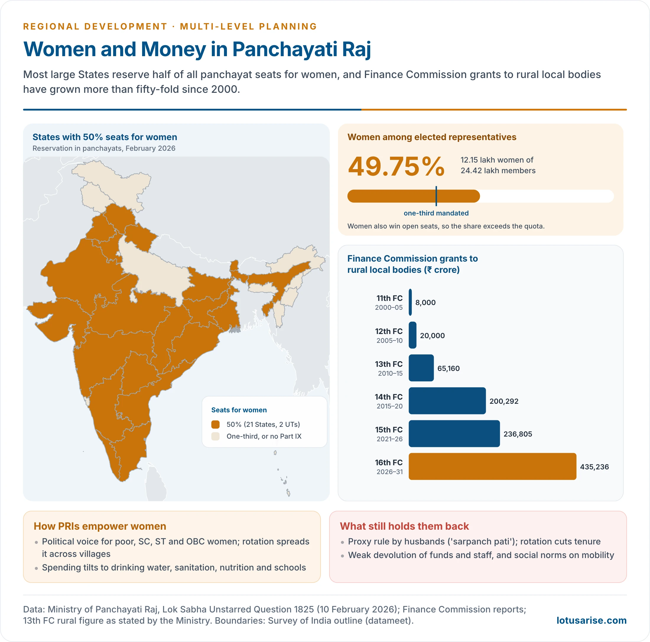
- 21 States and 2 UTs have raised this to 50%, among them Bihar (the first, in 2006), Madhya Pradesh, Rajasthan, Maharashtra, Keralam, Odisha, West Bengal and Andhra Pradesh.
- The Union Cabinet resolved on 27 August 2009 to reserve 50% of panchayat seats for women. In 2009 there were 28.18 lakh elected representatives, 36.87% of them women.
- Scale (February 2026): of 24.42 lakh elected representatives, 12.15 lakh (49.75%) were women, the world’s largest body of women in elected office. The figure exceeds the reserved share because women also win open seats.
How PRIs Empower Women
- Political voice: millions of women from poor, SC, ST and OBC households have entered public office. Rotation of reserved seats spreads the experience across villages.
- Changed priorities: studies of reserved seats in West Bengal and Rajasthan found that women-led councils invested more in drinking water, roads and other goods that women had asked for. Women pradhans have also pushed sanitation, nutrition, school enrolment and anganwadi services.
- Confidence and leadership: elected women gain public standing, mobility and bargaining power at home. Many move from ward member to pradhan, and then to block and district office.
- Institutional channels:
- mahila sabhas held before the gram sabha in several States;
- women’s quorum rules in gram sabhas;
- gender-responsive GPDPs;
- Model Women-Friendly Gram Panchayats (744 identified across 32 States and UTs in 2025–26).
- Convergence with SHGs: DAY-NRLM’s women’s collectives now prepare Village Prosperity and Resilience Plans for the GPDP. SHG leaders often contest panchayat seats, as Kudumbashree members in Keralam do.
- Capacity building: the Revamped Rashtriya Gram Swaraj Abhiyan (2022–26) trained about 28.6 lakh women representatives by December 2025. The Sashakt Panchayat-Netri Abhiyan gives specialised leadership training.
Limits
- Proxy representation: the “sarpanch pati” or “pradhan pati”, where husbands or male relatives wield the office.
- On the Supreme Court’s direction, an advisory committee (2023) examined the practice. Its report (February 2025) proposed legal safeguards, penalties, social audit and training, and a task force was set up in April 2025.
- Rotation of reserved seats every term limits the time women have to build experience and a constituency.
- Patriarchal norms, illiteracy and low mobility, and harassment and violence against assertive women leaders.
- Weak devolution of funds and functionaries, which limits what any panchayat, run by men or women, can do.
- Two-child norms and educational qualifications for candidates in some States have excluded poorer women.
Achievements and Problems of Decentralised Planning
Achievements of the 73rd Amendment
- Regular elections to over 2.5 lakh gram panchayats and their equivalents. Over 24 lakh elected representatives, including SC, ST and women members, make it the widest base of representation in any democracy.
- Functions: States such as Keralam, Karnataka, Maharashtra, West Bengal and Rajasthan devolved many Eleventh Schedule subjects with staff and funds.
- Finances: Finance Commission grants to rural local bodies grew steadily, all of them devolved to elected panchayats:
| Finance Commission | Award period | Grants to rural local bodies |
|---|---|---|
| 11th | 2000–05 | ₹8,000 crore |
| 12th | 2005–10 | ₹20,000 crore |
| 13th | 2010–15 | ₹65,160 crore |
| 14th | 2015–20 | ₹2,00,292 crore |
| 15th | 2021–26 | ₹2,36,805 crore (plus health grants to local bodies) |
| 16th | 2026–31 | ₹4,35,236 crore |
- The 16th Finance Commission recommended ₹7,91,493 crore for all local bodies: ₹4,35,236 crore rural and ₹3,56,257 crore urban. Basic and performance grants, 80% and 20%, are split 60:40; urban bodies also get ₹66,100 crore as a special infrastructure component and urbanisation premium.
- Entry conditions: constitution of the local bodies, publication of their accounts, and timely constitution of State Finance Commissions.
- Participatory planning: GPDPs in almost every panchayat; gram sabhas that approve beneficiary lists, plans and social audits; and works chosen locally under the rural employment programme.
- Service delivery: drinking water under the Jal Jeevan Mission, sanitation, rural housing and roads are increasingly planned and monitored by panchayats.
Merits of Decentralised Planning
- Cost-effective decisions: centralised planning faces high information costs, loss of time, uniform schemes ill-suited to local conditions and distortions as decisions pass down the line. Several semi-autonomous levels with real powers decide better, and socio-political compulsions may in any case require powers to be shared.
- More freedom for regional bodies and local enterprise, and less bureaucratic delay and red tape.
- Planning from below spreads political and economic authority to lower and horizontal levels, values local factors and suits a pluralistic society.
- Realistic plans: central planners often do not know ground realities. Local planners do.
- It guards against concentration of power and encourages individual initiative.
Problems and Demerits
- Decentralised plans may not reflect national priorities, and may weaken the integrating forces needed against divisive ones.
- Local elites may corner benefits or block changes that empower other groups; the disadvantaged may be too weak to claim their share.
- Limited technical capacity at lower levels: few planners, engineers and accountants in gram panchayats. Many representatives, women especially, have had little preparation in planning and management, so progress has been slow and halting.
- No clear concept: PRIs are seen variously as administrative agencies, as grassroots democracy and as rural government.
- Weak political will: elections are delayed in some States, and MPs and MLAs often see panchayat members as rivals.
- Role of bureaucracy: officers see themselves as agents of government, and dislike working under panchayat members.
- Factions: the wealthy and influential tend to win, and elections can divide villages into hostile groups.
- Incomplete devolution: the “3Fs” (functions, funds, functionaries) remain largely with State departments.
- Panchayats raise little own-source revenue. Most of their money comes as tied grants for central schemes.
- Parallel bodies: user committees, project societies and MP and MLA local area funds bypass panchayats.
- Weak DPCs and MPCs, so plans are not integrated vertically; delayed elections and the supersession of local bodies in some States.
- On balance, an optimum mix of centralised and decentralised planning is desirable.
- Core-sector industry, communications and inter-State infrastructure need central planning.
- Agriculture, rural development, water supply and local services benefit from decentralised planning.
- Widely dispersed, resource-diverse, location-specific problems, rural development above all, need decentralised planning most.
People’s Participation
- Channels:
- the gram sabha and, in towns, ward sabhas and committees;
- social audits of works and payments, pioneered at scale in Andhra Pradesh under the rural employment guarantee;
- user groups for water, forests and watersheds;
- SHG federations;
- public disclosure of works and funds on panchayat walls and portals.
- What participation achieves: plans that match local priorities, better identification of the poor, lower leakage and ownership of assets.
- Conditions for it to be meaningful:
- real powers and money at the level where people meet;
- information in time;
- fixed gram sabha calendars and quorum rules;
- representation of women, SC, ST and the landless;
- and follow-up, so that decisions are seen to be carried out.
- Obstacles: low gram sabha attendance, domination by caste and landed elites, gender norms, lack of information, and the feeling that decisions are made elsewhere.
A Blueprint for Integrated Regional Development Planning
- Delineate nested planning regions: a village cluster or micro-watershed, the block, the district and a planning region of several districts. Agro-climatic zones or river basins can serve as the regional frame.
- Build the resource and needs base: a GIS inventory of land, water, forests, minerals, settlements, services and poverty, with Gram Manchitra and Panchayat Advancement Index data.
- Plan the settlement system: a hierarchy of central villages, service centres, growth points and towns, so that services and markets are within reach and growth impulses spread.
- Prepare plans bottom-up:
- GPDPs and ward plans at the base;
- block plans for employment, credit and minor irrigation;
- an integrated district plan through the DPC;
- a regional plan that adds inter-district infrastructure, industry and environment.
- Converge budgets: central schemes, State plans, Finance Commission grants, CSR and credit mapped onto the same spatial plan, with the employment programme’s works shelf drawn from it.
- Protect the environment: watershed treatment, eco-sensitive zones and climate risk built into every level.
- Monitor outcomes through dashboards and social audit, with the aspirational-district method of ranking and competition.
Way Forward
- Genuine devolution: clear activity mapping of functions among the three tiers, with untied, predictable funds and trained staff. Strengthen own-source revenue: property tax, user charges and local fees.
- Active, professional DPCs:
- GIS-based planning and sectoral experts;
- a statutory duty to integrate GPDPs, block plans and municipal plans into one district plan;
- a link to State budgets.
- Data-driven planning: integrate eGramSwaraj, Gram Manchitra, the Panchayat Advancement Index, aspirational district and block dashboards and SDG localisation into one planning platform.
- Strengthen gram sabhas, so that planning does not become a clerical exercise: fixed calendars, quorum rules, mahila sabhas and social audit.
- Convergence of local plans with:
- the rural employment guarantee;
- the Jal Jeevan Mission;
- PMAY-G;
- DAY-NRLM;
- PMKSY and watershed development;
- health and education missions;
- climate adaptation.
- Women’s leadership: longer tenure of reserved seats, end proxy representation through training and penalties, and support networks for elected women.
- Outcome-based monitoring: poverty reduction, school attendance, health outcomes, water security, livelihoods and environmental sustainability, not expenditure alone.
- Multi-level planning combines national direction, State leadership, district coordination and grassroots participation. It is not only an administrative technique but a democratic instrument for inclusive and sustainable development.
Previous Year Questions
2026Discuss how Panchayati Raj institutions play a crucial role in the empowerment of women in India.2024The 73rd Constitutional Amendment Act devolved functions, finances and functionaries for planning of rural areas in India. Discuss the major achievements with examples.2022Can the Panchayat Raj institutions play a role in grassroot level planning in India? If yes, discuss how.2021Critically examine how the Panchayati Raj system is a catalyst in decentralized planning in India.2020The success of Panchayati Raj depends upon meaningful participation of people at the grassroots level. Examine.2018Examine the role of people’s participation in successful decentralized planning in India.2017“An effective three-tier Panchayat Raj System will strengthen the bottom-up approach to multi-level planning in India.” Explain.2015Decentralized planning through the strengthening of the Panchayat system is the focus of planning in India in recent times. Suggest a blueprint for an integrated regional development plan.2015Discuss the concept of multi-level planning as practised in India, and explain the implications of 73rd and 74th constitutional Amendments in this respect.2007Critically examine the Panchayati Raj setup.2005Discuss Panchayati Raj as a measure of decentralised planning in India.2002Give a reasoned account of regional disparities in economic development in India and bring out the contribution of decentralised planning in solving this problem.2000Explain the concept of multi-level planning in India.1999Write short note: Nature and utility of multi-level planning in India.1997Evaluate the benefits of block level development planning in India.1992Examine critically the advantages and disadvantages of multi-level planning with special reference to India.1988Write short note: Significance of District Planning in India.





I following this site from very first of my prepration..this site always gives me extra edge of information..thank u lotus arise🙏
dipti #are u prepapring for upsc?///geography optional????
r u done with it?
very helpful sir
Pdf mil jayegi
https://store.lotusarise.com/
questions for active revision