

Command Area Development

- India’s irrigation policy after Independence focused heavily on building large dams, reservoirs and canal networks. However, by the early 1970s, a serious policy gap became visible: irrigation potential was being created, but not fully utilised at the farm level. Water reached the canal system, but often failed to reach every farmer’s field in the right quantity, at the right time, and in a reliable manner.
- It was to address this “last-mile irrigation gap” that the Command Area Development Programme (CADP) was launched in December 1974 as a Centrally Sponsored Scheme. Its central idea was simple but transformative: irrigation development should not stop at dam and canal construction; it must continue up to the farm gate through field channels, drainage, land levelling, water scheduling, farmer participation and scientific crop planning.
Meaning of Command Area Development
- A command area is the cultivable area that can be irrigated by a particular irrigation project, canal system or water source. Command Area Development refers to the systematic development of this area so that the irrigation potential already created through major and medium irrigation projects is actually used for raising agricultural productivity.
- In other words, CAD is the bridge between irrigation infrastructure and agricultural outcome.
Genesis of the Command Area Development Program
- The Irrigation Commission in 1972 and the Committee of Ministers in 1973 highlighted the growing gap between irrigation potential created and irrigation potential utilised. They recommended a coordinated area development approach for each major irrigation project.
- Accordingly, CADP was launched in 1974-75. Initially, it covered 60 major and medium irrigation projects with a Culturable Command Area of about 15 million hectares. Later, its scope expanded across several States and Union Territories. In 2004, the programme was restructured and renamed as the Command Area Development and Water Management Programme (CADWM) to give greater emphasis to efficient water management, farmer participation and sustainability.
- At present, CADWM is linked with the broader irrigation vision of Pradhan Mantri Krishi Sinchayee Yojana (PMKSY), especially the objective of “Har Khet Ko Pani”.
- The programme seeks to achieve three broad objectives:
- Bridging the gap between irrigation potential created and utilised through micro-level infrastructure.
- Optimising agricultural production and productivity by ensuring timely and equitable water supply.
- Improving the socio-economic condition of farmers through better water use, higher yields and participatory irrigation management.
- Modernisation: The program entered its most recent phase, M-CADWM, in April 2025, focusing on high-tech infrastructure like pressurised pipe networks and digital monitoring.
- Thus, the programme is not merely an engineering scheme; it is an integrated rural development intervention.
Command Area Development Programme
- The Command Area Development Programme was launched in 1974-75 with the set objectives of improving the utilization of created irrigation potential and optimizing agriculture production and productivity from irrigated agriculture through a multidisciplinary team under an Area Development Authority. It is about the command areas of the major and medium irrigation projects in the country.
- The programme was restructured and termed as “Command Area Development and Water Management (CADWM) Programme” from 1 April 2004.
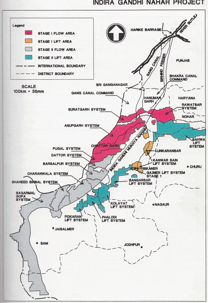
- This programme was initially introduced in 60 major and minor projects, including the Indira Gandhi Canal Command Area in 1974.
- Subsequently, the Command Area Development Programme has spread 110 districts in 13 states, covering about 15 million hectares of irrigated agricultural land.
- So far it has covered 310 irrigation projects with a Culturable Command Area (CCA) of about 28.45 mha.
- Financial assistance is provided to the state governments on a 50:50 basis for the construction activities.
Major Components of the Programme
- The CADWM Programme includes both physical and institutional components.
- On-Farm Development Works
- This includes construction of field channels, field drains, land levelling, land shaping and realignment of field boundaries. Field channels are crucial because they carry water from the outlet to individual farms. Without them, canal irrigation remains incomplete.
- Warabandi System
- Warabandi means rotational distribution of irrigation water among farmers. It aims to ensure equity between head-reach and tail-end farmers. This is particularly important in canal commands where upstream farmers often receive more water than downstream farmers.
- Drainage Development
- Irrigation without drainage can create waterlogging and salinity. Therefore, CAD includes field drains, intermediate drains and link drains to remove excess water and protect soil health.
- Reclamation of Waterlogged Areas
- Waterlogging reduces productivity and damages soil structure. CADWM provides for preventive and remedial measures such as surface drainage, sub-surface drainage, vertical drainage and, where feasible, bio-drainage.
- Correction of System Deficiencies
- Many irrigation systems perform below capacity due to siltation, damaged channels, poor maintenance and inadequate control structures. CADWM therefore includes correction of deficiencies above the outlet up to distributaries of specified capacity.
- Farmer Participation
- Formation of Water Users’ Associations (WUAs) is a key institutional reform. Farmers are expected to participate in planning, execution, distribution of water and maintenance of field channels and drains.
- Adaptive Trials and Demonstrations
- Scientific water management practices such as border irrigation, furrow irrigation, check basin methods, optimal irrigation intervals and crop-water scheduling are tested and demonstrated for farmers.
- Training and Extension
- The programme includes training of irrigation officials, CAD authorities, field staff and farmers. Institutions such as WALMIs play an important role in building capacity on water management, participatory irrigation and crop planning.
Achievements of CAD
- CAD has contributed to the creation of micro-level irrigation infrastructure in several canal commands. Field channels have been constructed, warabandi has been introduced in many areas, and awareness of participatory irrigation management has improved.
- The programme also shifted the policy focus from mere construction of irrigation projects to efficient utilisation of created potential. This is a major conceptual achievement in Indian irrigation planning.
- However, the achievements have been uneven. In many States, CAD became narrowly focused on field channel construction, while broader goals such as crop diversification, drainage, farmer participation and integrated water management received less attention.
Major Problems and Weaknesses
- The most serious weakness of CAD has been the unreliability of irrigation water supply. If water does not reach the outlet predictably, field channels and warabandi alone cannot solve the problem.
- Other major challenges include:
- Poor coordination among irrigation, agriculture, revenue, credit and extension departments.
- Limited authority of CAD agencies over water release and agricultural inputs.
- Inadequate maintenance of canals and field channels.
- Weak farmer participation in many projects.
- Conflict between head-reach and tail-end farmers.
- Slow progress in land levelling due to small holdings and high cost.
- Inadequate drainage leading to waterlogging and salinity.
- Insufficient monitoring and evaluation.
- Lack of reliable field-level data on crop productivity, water use and farmer income.
- Thus, the programme’s challenge is not only technical but also institutional.
Need for a Holistic Approach
- For CAD to succeed, irrigation must be managed from headworks to farm gate as one integrated system. The completion of on-farm development works should be seen as the beginning of improved water management, not the end of the programme.
- A strong CAD strategy must include:
- assured water delivery,
- functional WUAs,
- conjunctive use of surface and groundwater,
- drainage management,
- crop planning according to water availability,
- regular maintenance,
- scientific monitoring,
- and convergence with agriculture, credit, markets and rural infrastructure.
Contemporary Relevance
- The relevance of CAD has increased in the context of climate change, groundwater depletion and rising demand for “more crop per drop”. In April 2025, the Union Cabinet approved Modernisation of Command Area Development and Water Management (M-CADWM) as a PMKSY sub-scheme for 2025-26 with an initial outlay of Rs. 1,600 crore.
- The modernised approach emphasises underground pressurised piped irrigation, micro-irrigation support, SCADA, Internet of Things-based water accounting, and Irrigation Management Transfer to Water User Societies.
- This shows that CAD is evolving from traditional canal command development to a more technology-enabled, farmer-managed and efficiency-oriented irrigation model.
Administrative and Financial Framework of CAD
- The administrative and financial framework of the Command Area Development (CAD) program has evolved from a traditional top-down authority model to a decentralised, participatory, and increasingly modernised system. It operates through a multi-tier structure involving central, state, district, and community-level entities.
1. Administrative and Institutional Framework
- The program is implemented as a cooperative federal initiative where the central government provides policy direction and funding, while state governments handle execution.
- Central Level: The Ministry of Jal Shakti (Department of Water Resources, River Development & Ganga Rejuvenation) acts as the nodal agency. The Central Water Commission (CWC), through its CAD Cells and Project Monitoring Organization (PMO), provides overall monitoring, coordination, and appraisal of Detailed Project Reports (DPRs).
- State Level: Implementation is the responsibility of State Governments, typically through Command Area Development Authorities (CADAs). These are often semi-autonomous bodies led by a CAD Commissioner or Secretary and are intended to be multidisciplinary, incorporating experts in engineering, agronomy, and soil science.
- District and Local Level: Under recent modernization (M-CADWM), a District Level Implementation Committee (DLIC), chaired by the District Collector, oversees cluster selection and inter-departmental coordination. At the grassroots, Water Users’ Associations (WUAs) or Water User Societies (WUS) are mandatory; they are responsible for local operation and maintenance (O&M) and water distribution after infrastructure is handed over by the government.
- New Modernization Roles (M-CADWM):
- Irrigation Service Providers (ISP): Contractors who provide “Irrigation as a Service” (IaaS) and are accountable to the WUS for water delivery.
- Farmer Relationship Agencies (FRA): Specialized institutions (like universities or NGOs) that provide handholding, training, and capacity building for WUS development.
2. Financial Framework
- The program is funded as a Centrally Sponsored Scheme, with costs shared between the Union and the States based on specific ratios and ceiling costs.
- Cost-Sharing Ratios
- The funding pattern varies depending on the state category and the type of activity:
- General Funding Pattern: Typically 60:40 (Centre:State) for most states.
- Special Category States: For the North Eastern and Himalayan states (and Union Territories like J&K and Ladakh), the ratio is 90:10.
- Specific Activity Ratios (Prioritized Projects):
- Structural Interventions: Usually shared 50:50 between Centre and State.
- Non-Structural Interventions: Generally 60:40 (Centre:State), but 75:25 for North Eastern/Himalayan states.
- Functional Grants to WUAs: A one-time grant (e.g., ₹1,000–₹1,200 per hectare) shared as 45:45:10 (Centre:State:Farmer) to encourage local ownership.
- The funding pattern varies depending on the state category and the type of activity:
- Budgetary Mechanisms and Outlays
- PMKSY Integration: Since 2015-16, CADWM has been a sub-component of Pradhan Mantri Krishi Sinchayee Yojana (PMKSY) under “Har Khet Ko Pani”.
- NABARD Funding: To ensure steady progress for 99 prioritized projects, funding is often routed through the Long Term Irrigation Fund (LTIF) via NABARD.
- M-CADWM Outlay: The 2025 modernization update has an initial outlay of ₹1,600 crore (₹1,100 crore Central share, ₹500 crore State share) for pilot projects.
- Procedure for Release of Funds
- Central Assistance is released in two installments:
- First Installment (60%): Released based on annual targets and the submission of a checklist for holistic implementation.
- Second Installment (40%): Released after the state submits Utilization Certificates (UCs) showing that at least 50% of the first installment has been spent, along with physical progress reports.
- Central Assistance is released in two installments:
3. Monitoring and Accountability
- Three-Tier Monitoring: Includes field-level monitoring by CWC CAD Cells, assimilation of cross-learning by the PMO, and overall project review by a Project Implementation Review Committee (PIRC) at the zonal level.
- Digital Governance: Progress must be updated monthly on a web-based Management Information System (MIS). Modernized projects utilize SCADA and IoT for real-time water accounting and performance-linked incentives.
- Audits: Annual third-party audits of WUAs and financial audits by the Comptroller and Auditor General (CAG) or State Auditor General are mandatory to ensure transparency.
Indira Gandhi Canal Command Area Development Program
- The Command Area Development was introduced in the Indira Gandhi Canal Command Area in 1974.
- The main objectives of the Indira Gandhi Canal Command Area were as under:
- To Reduce Water Pilferage of Canal Water: The wastage of water results not only in under-utilisation of water but also leads to water-logging and soil salinity, affecting adversely the yield and production of crops.
- Development of Social Amenities and Infrastructural Facilities: Since the Indira Gandhi Canal Command Area was newly colonised, there was an urgency to provide civic amenities and infrastructural facilities to supply the necessary agricultural inputs to the farmers. Emphasis, therefore, was laid on the construction of roads, markets and storage facilities to enhance agricultural production.
- Control of Wind Erosion: There was a serious menace of wind erosion in the Indira Gandhi Canal Command Area which was a potential danger for the silting of the canal and its distributaries. Therefore, efforts need to be made to reduce the wind erosion in the command area of the canal.
- lining of the Canal: The areas through which the canal passed being desertic and sandy, there was a strong possibility of water seepage and waterlogging. To check and minimize the water seepage, lining of the canal was imperative.
- Reclamation of Land: Provisions for leveling of land and reclamation of degraded land.
- Afforestation and Pastures Development: Afforestation along the banks of the canal, its distributaries as well as along the new rural and urban settlements to stabilize the sand dunes. The migratory sand dunes not only damage the arable land and pastures but also bury the orchards and settlements under the sand.
- Implementation of the Indira Gandhi Canal Command Area has helped in bringing the land under irrigation rapidly, increase in water use efficiency, agricultural production, and productivity.
- The improvement in irrigation not only led to a phenomenal increase in agriculture production but also introduced changes in the patterns and rotation of crops.
- Due to the availability of canal water, farmers have adopted the cultivation of wheat, barley, groundnut, mustard, cotton, green manuring crops, orchards, and vegetables in place of Bajara, Millets, and Pulses.
- The Indira Gandhi Canal has brought much prosperity to farmers of the region and cropping patterns have changed substantially.
- However, there occurred numerous environmental and ecological problems in the command area. Apart from waterlogging, the underground water table is rising, rendering the agricultural and pasture lands useless from the agriculture point of view.
- The water-logged areas have become the breeding grounds for mosquitoes and malaria. These problems need to be addressed on a priority basis.
- The Command Area Development and Water Management (CADWM) Programme was started initially in December 1974 to improve the irrigation potential utilization and optimize the agricultural production and productivity through the integrated and coordinated approach of efficient water management.
- Who implements the program?
- The Ministry of Water Resources coordinates and monitors the implementation of CADWM at the national level and the Programme is being implemented through the Command Area Development Authorities (CADAs) at the State level.
- Initially, 60 major and medium irrigation projects were taken up under the CAD Programme, covering a Culturable Command Area (CCA) of about 15.00 million hectares.
- During XII Plan, the CADWM programme has been implemented with Accelerated Irrigation Benefits Programme (AIBP). The programme is being implemented under Pradhan Mantri Krishi Sinchai Yojna (PMKSY) – Har Khet Ko Pani from 2015-16. The ongoing CADWM programme has now been restricted to the implementation of CAD works of 99 prioritized AIBP projects.
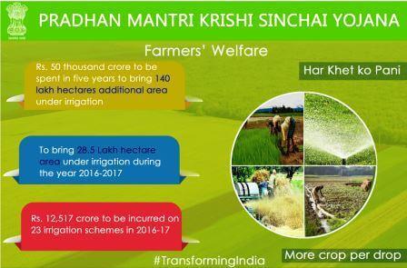
Pradhan Mantri Krishi Sinchai Yojna (Pmksy)
- PMKSY is a proposed scheme by the Government of India which envisaged to connect the irrigation system’s three crucial components – the Field application, water sources, and distribution network for optimal usage
- The new irrigation scheme assumes importance as 65 percent of the total 142 million hectares of farmland in the country are still not covered under irrigation.
- The PMKSY intends to focus on an ‘end-to-end solution‘ in the irrigation supply chain by implementing the new program in a “project mode” with decentralized state-level planning and execution.
- The PMKSY projects would be scrutinized by the State Level Project Screening Committee (SLPSC) and sanctioned by the State Level Sanctioning Committee already set under Rashtriya Krishi Vikas Yojana.
- The state agriculture department would be the nodal agency for implementation of PMKSY projects, while there would also be an inter-ministerial National Steering Committee (NSC) for periodic review of the same.
- A state will become eligible to access PMKSY funds only if it has prepared the district irrigation plans and state irrigation plans and sustained an increasing expenditure trend in the irrigation sector in the state plan.
- PMKSY funds would be given to states as 75 percent grant by the central government and the remaining 25 percent share is to be borne by the state government. For the northeastern regions and hilly states, the funding pattern would be 90:10.
- PMKSY Envisages Interlinking of Perennial Rivers to avoid Drought and Flood Situations.
- Strengthening of Krishi Vikas Kendras or Agriculture Science Centres in all the districts of the country to aid the farmers with new technology up-gradation for irrigation.
- Linkage of the scheme with Mahatma Gandhi National Rural Employment Scheme to channelize the available workforce to productive and value-added work.
Modernization of Command Area Development and Water Management (M-CADWM)
The Modernization of Command Area Development and Water Management (M-CADWM) is a high-tech sub-scheme of the Pradhan Mantri Krishi Sinchayee Yojana (PMKSY) approved by the Union Cabinet in April 2025. Designed to represent a paradigm shift to “Irrigation 4.0,” the program moves away from traditional gravity-based open canal systems toward a modernized, demand-led, and digitally managed irrigation infrastructure.
1. Core Objectives and Paradigm Shift
The primary goal of M-CADWM is to bridge the persistent gap between irrigation potential created and utilized while significantly boosting Water Use Efficiency (WUE).
- Efficiency Targets: It aims to increase on-farm water use efficiency from the current average of 35% to 75%.
- Sustainable Management: The scheme shifts from a “supply-side” engineering focus to a “demand-side” management approach, treating all water sources (surface, ground, and reused water) as a single resource in a cluster.
- Farmer Prosperity: By enabling precision agriculture through reliable water delivery, the program seeks to increase agricultural production, crop diversification, and overall farmer income.
2. Technological Infrastructure
M-CADWM introduces several cutting-edge technologies to modernize the irrigation network:
- Pressurized Piped Irrigation Networks (PPIN): The traditional open field channels are replaced by underground pressurized pipes. This eliminates evaporation and percolation losses (typically 20-30%) and serves undulating terrains without requiring individual farmer pumps.
- SCADA and IoT Integration: The system uses Supervisory Control and Data Acquisition (SCADA) for centralized automated control and Internet of Things (IoT) sensors at the farm level to monitor soil moisture, pressure, and flow in real-time.
- Digital Water Accounting: Moving away from area-based fees, water usage is measured volumetrically through digital meters.
- Satellite-Based Monitoring: Daily satellite imagery is utilized to calculate evapotranspiration (ET) and soil moisture, ensuring that water supply matches the precise crop requirements.
3. Institutional and Management Reforms
A critical component of M-CADWM is the professionalization and decentralization of irrigation management:
- Water User Societies (WUS): The command area is divided into manageable clusters (50 to 5,000 ha) where farmers form a WUS. These societies are legally registered entities responsible for local distribution and charge collection.
- Irrigation as a Service (IaaS): Construction contractors are transformed into Irrigation Service Providers (ISPs). They are contracted for long periods (minimum 5 years post-construction) to ensure on-demand water delivery and are directly accountable to the WUS.
- Farmer Relationship Agencies (FRA): Specialized institutions (like universities or NGOs) provide five years of handholding support to WUSs, training them in technical, financial, and agri-business management.
4. Administrative and Financial Framework
The scheme operates under a multi-tier governance structure:
- Governance Levels: Includes an Empowered Committee at the central level, State Level Steering Committees chaired by Chief Secretaries, and District Level Implementation Committees (DLIC) led by District Collectors.
- Funding Pattern: The initial total outlay for 2025-2026 is ₹1,600 crore. The cost is shared between the Centre and States in a 60:40 ratio for general states and 90:10 for North Eastern and Himalayan states.
- Performance-Linked Incentives (PLI): Incentives are designed for States and WUSs that achieve early project completion or high levels of micro-irrigation adoption.
5. Implementation Phases
- Phase I (2025-2026): Focuses on pilot projects across various agro-climatic zones selected through challenge funding to the states.
- Phase II (April 2026 onwards): Based on learnings from the pilots, a full National Plan for Command Area Development and Water Management will be launched for the 16th Finance Commission period.
6. Expected Benefits
- Environmental Impact: Phase I alone is expected to conserve approximately 150 million cubic meters (MCM) of water and save an estimated 0.64 million kg of CO2 by eliminating the need for individual pumps.
- Economic Upliftment: By turning clusters into “Agri growth engines,” the scheme promotes “Make in India” for irrigation automation and creates direct livelihood opportunities for approximately 80,000 farmers in the pilot phase.
- Youth Engagement: The introduction of modern, tech-driven irrigation is intended to attract younger generations back to farming.





Excellent. Matter provided with powerful insights and knowledge.
Thanks Samvid
You people have put the information So perfectly and simply….to the point and exact! Great 👌