

- Large dams and mining are the two most direct ways in which the economy rearranges the hydrosphere and the lithosphere. A dam re-plumbs a river basin; a mine removes and re-piles the crust itself.
- Both are part of the wider human impact on ecology and environment, but they are concentrated, engineered and long-lived: a reservoir or an open pit changes a landscape for centuries.
- Economic geology is the study of earth materials that people use for economic ends: metallic and non-metallic minerals, fossil fuels, construction materials and groundwater, with their origin, exploration and extraction.
- Its environmental implications arise at every stage: exploration, extraction, beneficiation, smelting, transport, use and waste disposal.
- Both activities carry a classic development dilemma: water, power, food security and raw materials on one side; submergence, displacement, pollution, habitat loss and disaster risk on the other.
- The costs fall mostly on forest, riverine and tribal communities, while the benefits flow to cities, industry and irrigated plains. This makes dams and mines a core theme of political ecology as well as environmental science.
Large Dams and the Environment

What counts as a large dam
- The International Commission on Large Dams (ICOLD, founded 1928) defines a large dam as one 15 m or more in height from the lowest foundation to the crest.
- A dam of 5–15 m also counts if it impounds more than 3 million m³ of water.
- India’s Dam Safety Act, 2021 uses the term “specified dam”: a dam above 15 m, or 10–15 m high when it meets set design conditions (large reservoir, high flood discharge and so on).
- Numbers:
- The world has more than 58,000 large dams on ICOLD’s register. China, the USA and India have the most.
- India’s National Register of Large (Specified) Dams 2023 lists 6,138 completed and 143 under construction, a total of 6,281.
- Maharashtra alone has 2,333 completed large dams; Madhya Pradesh and Gujarat follow.
- About 234 of India’s large dams are more than a century old, and a large share are over 50 years old. Ageing is now a safety issue in its own right.
| Type | Function | Indian example |
|---|---|---|
| Storage (multipurpose) dam | Stores monsoon flow for irrigation, power, flood control, water supply | Bhakra, Hirakud, Sardar Sarovar, Tehri |
| Diversion dam or barrage | Raises water level to divert flow into canals; little storage | Farakka, Harike, Prakasam |
| Run-of-river hydropower | Small pondage; water passes through tunnels and turbines | Many Himalayan projects (Teesta, Alaknanda, Bhagirathi) |
| Pumped storage | Pumps water uphill in surplus hours, generates at peak | Tehri pumped storage, Srisailam |
| Embankment (earth or rockfill) | Mass of earth and rock; suits broad valleys | Tehri (260.5 m, India’s tallest), Hirakud |
| Concrete gravity or arch | Weight of concrete (gravity) or arch thrust resists water | Bhakra (226 m), Sardar Sarovar; Idukki (arch) |
Why dams are built: benefits
- Irrigation: storage evens out the seasonal monsoon, turning one rain-fed crop into two or three irrigated crops. Large canal commands underpinned the Green Revolution.
- Hydropower: hydroelectric power is renewable, has low operating emissions and gives flexible peaking power. Pumped storage now balances solar and wind output on the grid.
- Flood moderation: reservoirs absorb flood peaks, as the Damodar Valley dams were designed to do for lower Bengal.
- Drinking and industrial water for cities: Chennai, Bengaluru, Delhi and Hyderabad all depend on distant reservoirs.
- Inland navigation, reservoir fisheries, tourism and drought-proofing of dry regions such as Saurashtra, Kachchh and western Rajasthan.
- Jawaharlal Nehru called such projects the “temples of modern India” when dedicating Bhakra. The multipurpose river valley projects of the 1950s–70s became symbols of national development.
Environmental threats of large dams
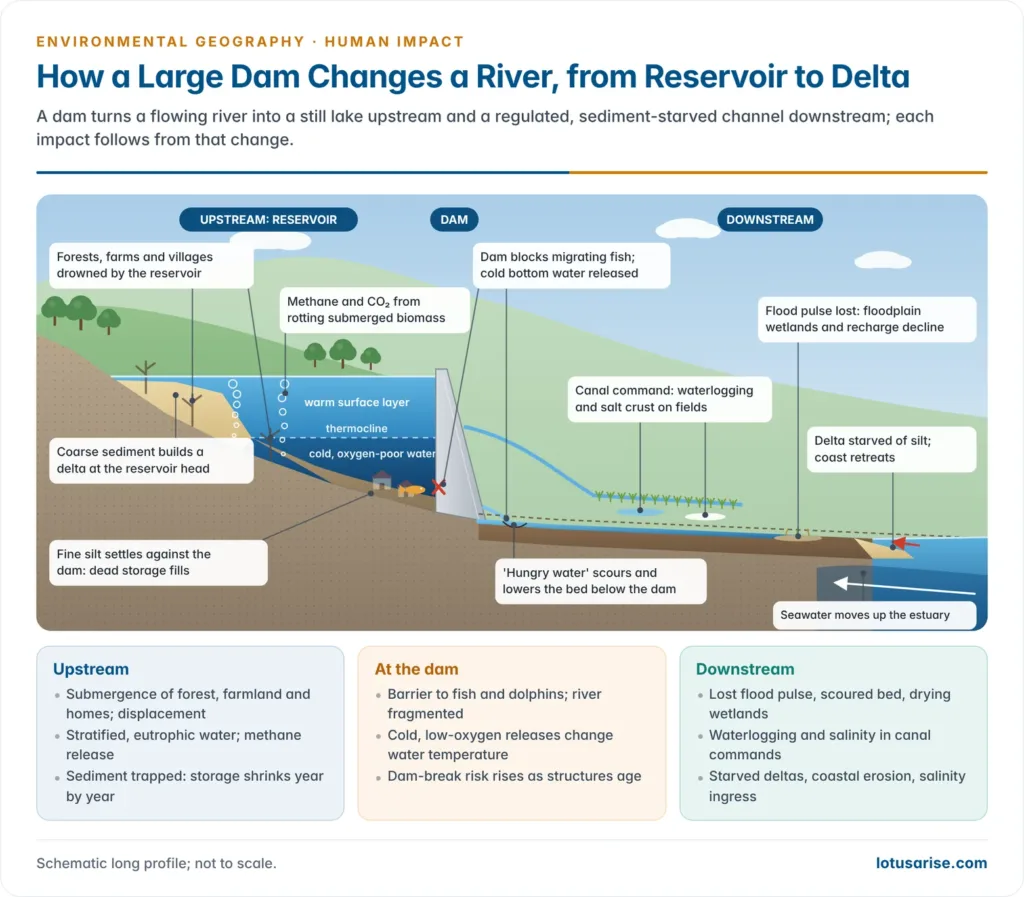
- A dam turns a flowing (lotic) river into a still (lentic) lake upstream and a regulated, sediment-starved channel downstream. Almost every impact follows from that single change.
Upstream: submergence and the reservoir
- Submergence of land: forests, farmland, villages, sacred sites and wildlife habitat disappear under the reservoir.
- Valley floors are the most fertile and biodiverse parts of a landscape, so the loss is disproportionate to the area.
- Reservoirs also fragment habitat, isolating animal populations on either bank and cutting migration routes.
- Changes in water quality:
- Deep reservoirs stratify thermally: a warm surface layer over a cold, oxygen-poor hypolimnion.
- Decaying submerged vegetation and nutrient inflow cause eutrophication, algal blooms and weeds such as water hyacinth.
- Anoxic bottom water releases iron, manganese and hydrogen sulphide.
- Greenhouse gases: flooded biomass decomposes and releases carbon dioxide and methane.
- Warm, shallow tropical reservoirs emit most. Global estimates put reservoir emissions at roughly 1.3% of human greenhouse-gas emissions, mostly as methane.
- So hydropower is low-carbon but not zero-carbon.
- Evaporation loss: large, shallow reservoirs in hot, dry regions lose a sizeable share of stored water to the air.
- Health: still water and seepage zones breed vectors. Malaria and schistosomiasis rose around the Aswan High Dam, and malaria spread in some Indian canal commands.
- Upstream backwater can flood areas far above the dam: Polavaram’s backwater is a dispute among Andhra Pradesh, Telangana, Odisha and Chhattisgarh.
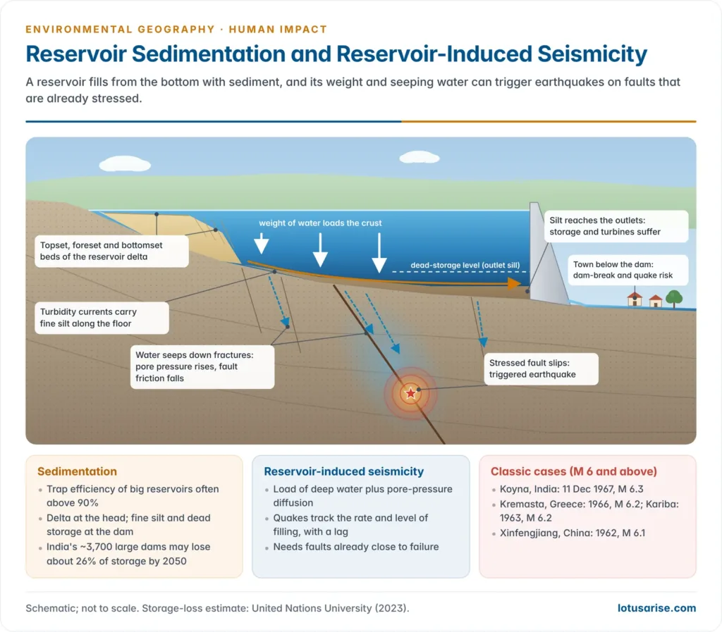
Sedimentation and loss of storage
- Every river carries sediment. When it enters the still reservoir, flow velocity drops and the load settles.
- Coarse load builds a delta at the head of the reservoir; fine silt and clay travel further as turbidity currents and settle against the dam.
- The trap efficiency of a large reservoir is often above 90%: nearly all incoming sediment stays behind the wall.
- Consequences:
- Steady loss of live storage, reducing irrigation, power and flood-cushion capacity.
- Abrasion of turbines in Himalayan projects that carry quartz-rich silt in the monsoon.
- Raised bed and backwater at the reservoir head, worsening upstream flooding.
- Indian scale:
- India loses an estimated 5.3 billion tonnes of soil a year to erosion, and about 10% of it ends up in reservoirs.
- A United Nations University study (2023) estimated that India’s roughly 3,700 large dams will lose about 26% of their original storage by 2050.
- Root cause: catchment degradation. Deforestation, road cutting and mining in the hills multiply sediment yield, so a dam’s life is decided far upstream of it.
Reservoir-induced seismicity
- Reservoir-induced (triggered) seismicity (RIS) is earthquake activity set off by filling or emptying a large reservoir, usually where faults are already close to failure.
- Two mechanisms:
- Loading: the weight of a deep water column adds stress to the crust beneath.
- Pore-pressure diffusion: water seeps down fractures, raising pore-water pressure and reducing the friction that locks a fault.
- Seismicity often follows the rate and level of filling, with a lag of months as pressure diffuses.
- Koyna (Maharashtra): the reservoir was impounded in 1962. On 11 December 1967 a magnitude 6.3 earthquake struck near the dam and killed about 180 people.
- It is the largest known case of RIS. Seismicity in the Koyna–Warna region still rises and falls with reservoir levels, as the work of seismologist Harsh K. Gupta documented.
- Other cases of magnitude 6 or above: Xinfengjiang, China (1962, M 6.1), Kariba, Zambia–Zimbabwe (1963, M 6.2) and Kremasta, Greece (1966, M 6.2).
- Implication: high dams in Seismic Zones IV and V, such as Tehri in the Garhwal Himalaya, need site-specific seismic design and dense monitoring networks.
Downstream: altered flow, sediment starvation and deltas
- Flow regulation: the natural flood pulse disappears. Floodplains lose the seasonal silt and moisture that renewed their soils, wetlands and fisheries.
- Too little water: diversion and abstraction can leave dry or near-dry stretches below dams and barrages in the lean season.
- The Ganga environmental flow notification (October 2018) set minimum flows for the upper Ganga: 20% of the monthly average in the dry season, 25% in the lean months and 30% in the high-flow season.
- Hungry water: water released from the dam has dropped its sediment, so it scours the bed and banks below, lowering the channel and undermining bridges.
- Delta starvation: with the sediment trapped upstream, deltas stop growing and the sea erodes them.
- After the Aswan High Dam (1970), the Nile delta coast retreated fast, and farmers had to replace the lost silt with chemical fertiliser.
- The Indus delta has shrunk under upstream barrages and dams.
- Salinity ingress: reduced freshwater flow lets seawater push up estuaries. The Narmada estuary near Bharuch turned more saline after Sardar Sarovar was completed, hurting fisheries and drinking-water supply.
- Lower groundwater recharge on floodplains that are no longer flooded.
- Mis-timed releases during extreme rain can worsen floods instead of moderating them. Releases from Chembarambakkam lake were blamed in part for Chennai’s 2015 flood, and the role of reservoir releases in the Kerala floods of 2018 is still debated.
Fish, river connectivity and aquatic life
- A dam is a barrier to migratory fish: species that breed upstream (such as mahseer) or move between sea and river (such as hilsa) lose access to spawning grounds.
- After Farakka Barrage (1975), the hilsa fishery of the middle Ganga, once important as far upstream as Allahabad, collapsed.
- Barrages fragment populations of the Gangetic river dolphin, India’s National Aquatic Animal, into isolated stretches.
- Cold, oxygen-poor water released from the bottom of a reservoir changes downstream temperature and kills sensitive species.
- Riparian forests and wetlands that depend on seasonal flooding wither.
- Fish ladders and passes help only some species and rarely work on high dams.
Command-area effects: waterlogging and salinity
- Canal irrigation without drainage raises the water table, causing waterlogging, and evaporation then draws salts up to form saline and alkaline (reh, kallar, usar) soils.
- Parts of the Indira Gandhi Canal command in western Rajasthan, and older canal tracts of Punjab, Haryana and the Tungabhadra and Chambal commands, show this problem.
- Monocropping of water-hungry crops (rice, sugarcane) in dry regions, and heavy fertiliser use, follow assured canal water.
- Seepage and standing water extend vector habitats; malaria rose in the Indira Gandhi Canal tract after irrigation arrived.
Social costs: displacement and resettlement
- The World Commission on Dams (2000) estimated that dams have physically displaced 40–80 million people worldwide, most of whom never regained their former livelihoods.
- In India, development projects have displaced tens of millions since 1947, and dams are the largest single cause. A disproportionate share are Adivasis.
- Problems of resettlement:
- loss of common property (forests, grazing land, river fisheries) that is rarely compensated;
- landless labourers, tenants and fisherfolk who hold no legal title;
- poor or delayed rehabilitation and the break-up of community and culture;
- “downstream displacement” of fishers and floodplain farmers, who are seldom counted.
- The Right to Fair Compensation and Transparency in Land Acquisition, Rehabilitation and Resettlement Act, 2013 now requires a social impact assessment, consent in some cases, and rehabilitation entitlements. The Forest Rights Act, 2006 gives gram sabhas a say over forest land.
Dam safety and disaster risk
- Dam failure is a low-probability, very-high-consequence hazard: the flood wave from a breach can be far larger than any natural flood.
- Machchhu-II, Morbi (Gujarat), 11 August 1979: the earthen dam failed under extreme rain, and thousands died in the town below.
- Tiware (Maharashtra), 2019 and Annamayya (Andhra Pradesh), 2021: small and medium dams breached in heavy rain, with deaths downstream.
- Teesta III (Sikkim), October 2023: the South Lhonak glacial-lake outburst destroyed the dam at Chungthang. Hydropower in high Himalayan valleys sits squarely in the path of high-altitude hazards.
- Causes of failure: overtopping by floods larger than the design flood, piping and seepage in earth dams, foundation weakness, earthquakes, and poor maintenance of ageing structures.
- Mullaperiyar: built in 1895 on the Periyar in Kerala and operated by Tamil Nadu under an 1886 lease, this ageing masonry dam is a long-running inter-state dispute.
- The Supreme Court allowed a water level of 142 ft in 2014. In 2025 it asked a reconstituted supervisory committee to resolve the two states’ operational disputes.
- Dam Safety Act, 2021 (passed in December 2021):
- sets up a National Committee on Dam Safety (policy) and a National Dam Safety Authority (regulator), with State Committees and State Dam Safety Organisations;
- requires owners to run pre- and post-monsoon inspections, prepare emergency action plans, and arrange periodic comprehensive safety evaluations by expert panels;
- provides penalties for obstruction and non-compliance.
- Debate: water is a State subject, so states such as Tamil Nadu questioned Parliament’s power to regulate dams wholly within a state.
- The Dam Rehabilitation and Improvement Project (DRIP) funds the repair of existing dams in its later phases (2021–2031).
Indian and global case studies
| Project | River and state | Key environmental and social issues |
|---|---|---|
| Sardar Sarovar (dedicated 2017; 163 m) | Narmada; Gujarat, with submergence in Madhya Pradesh and Maharashtra | Submergence of about 245 villages, mostly in the Nimar plains of Madhya Pradesh; Narmada Bachao Andolan; World Bank withdrawal (1993); salinity ingress in the estuary |
| Tehri (260.5 m) | Bhagirathi; Uttarakhand | Old Tehri town submerged; Seismic Zone IV; slope instability around the reservoir rim; opposed by Sunderlal Bahuguna |
| Polavaram (national project, 2014) | Godavari; Andhra Pradesh | About 1.9 lakh people affected, mostly Koya and Konda Reddi Adivasis; backwater submergence in Telangana, Odisha, Chhattisgarh; diaphragm wall damaged by the 2020 flood |
| Mullaperiyar (1895) | Periyar; Kerala (operated by Tamil Nadu) | Ageing masonry dam in a seismic area; inter-state dispute over safety and water level |
| Teesta III, Chungthang | Teesta; Sikkim | Destroyed by the 2023 South Lhonak GLOF; cascade of projects in a narrow Himalayan valley |
| Ken-Betwa link (Daudhan dam, 77 m) | Ken; Madhya Pradesh | About 9,000 ha submerged, including over 10% of Panna Tiger Reserve’s core |
| Three Gorges (22,500 MW) | Yangtze; China | About 1.3 million people relocated; reservoir landslides; sediment cut to the Yangtze delta |
| Aswan High Dam (1970) | Nile; Egypt | Delta erosion; loss of fertile silt; schistosomiasis; evaporation from Lake Nasser |
- Narmada and the political ecology of dams: the Narmada Bachao Andolan, led by Medha Patkar and joined by Baba Amte, questioned the costs and the beneficiaries of Sardar Sarovar.
- The independent Morse Review (1992) found resettlement and environmental planning inadequate, and the World Bank withdrew in 1993.
- The Supreme Court (October 2000) allowed construction to proceed with rehabilitation conditions.
- The case shows how a river is remade into produced nature, with costs and benefits distributed along lines of power and place. It remains the classic Indian example in people’s environmental movements.
- The Brahmaputra: China began building a very large hydropower complex on the lower Yarlung Tsangpo (Medog) in July 2025, estimated at about 60 GW.
- India has proposed the Siang Upper Multipurpose Project in Arunachal Pradesh as a storage buffer, but local Adi villages oppose the submergence. Transboundary dams add geopolitical and downstream-flow risk to the ecological one.
The World Commission on Dams (2000) and the dams debate
- The World Commission on Dams (WCD) was set up in May 1998 with support from the World Bank and IUCN, chaired by South Africa’s water minister Kader Asmal.
- It reviewed the record of about 1,000 dams in 79 countries. Its report, Dams and Development: A New Framework for Decision-Making, was released by Nelson Mandela in London in November 2000.
- Findings: dams had made an important contribution to development, but too often at an “unacceptable and often unnecessary” social and environmental cost.
- Large dams frequently fell short of their irrigation and power targets and exceeded their cost and time estimates.
- Ecosystem and species losses were often irreversible, and mitigation usually failed.
- Five core values: equity, efficiency, participatory decision-making, sustainability and accountability.
- Seven strategic priorities:
- gaining public acceptance;
- comprehensive options assessment (alternatives considered before a dam is chosen);
- addressing existing dams (their performance and outstanding impacts);
- sustaining rivers and livelihoods;
- recognising entitlements and sharing benefits;
- ensuring compliance;
- sharing rivers for peace, development and security.
- Reception: NGOs and affected people welcomed it. Several dam-building governments, India’s water resources ministry among them, rejected its key recommendations as impractical.
- Its framework still shapes environmental and social safeguard standards, sustainability protocols for hydropower and the language of free, prior and informed consent.
- Big dams versus small storage: critics argue that tanks, check dams, watershed treatment and groundwater recharge deliver water more cheaply and equitably. Supporters reply that only large storage can carry the monsoon surplus across seasons and regions.
River linking
- The National Perspective Plan (1980) proposes 30 links: 16 in the Peninsular and 14 in the Himalayan component, to move water from “surplus” to “deficit” basins. The National Water Development Agency (1982) studies them; the interlinking of rivers plan is the largest dam-and-canal scheme ever proposed in India.
- The Ken-Betwa link, the first to start, had its foundation stone laid on 25 December 2024, at an approved cost of ₹44,605 crore.
- Ecological and economic concerns:
- “Surplus” is questionable when monsoon peaks coincide in donor and recipient basins, and climate change makes flows less predictable.
- Submergence of forests and protected areas (Panna), new displacement and huge capital and energy costs for lifting water.
- Reduced freshwater and sediment to deltas (Ganga–Brahmaputra, Godavari, Krishna), raising salinity and coastal erosion.
- Mixing of biota between basins, and inter-state and international disputes (Nepal, Bangladesh).
- Intra-basin transfers and local storage within one basin are usually more feasible economically, socially and ecologically than long inter-basin links.
Mining and the Environment
Mining in India: scope and scale
- Mining is the extraction of valuable minerals from the earth. It is the most direct use of economic geology and the most visibly destructive, because it removes the ground itself.
- Mineral groups:
- Fuel minerals: coal and lignite, oil and gas, uranium.
- Metallic minerals: iron ore, bauxite, copper, zinc–lead, chromite, manganese, gold.
- Non-metallic and minor minerals: limestone, dolomite, mica, building stone, sand and gravel.
- Scale: India’s coal output crossed 1 billion tonnes in 2024–25, and demand for steel, cement and critical minerals (lithium, rare earths, graphite) is rising.
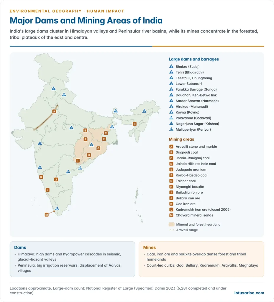
- Geography: most deposits lie in the ancient Peninsular rocks that are also India’s forest and tribal heartland.
- Chotanagpur, Odisha and Chhattisgarh hold most coal, iron ore and bauxite.
- The Karnataka–Goa iron belt and the Aravalli belt of Rajasthan add metals and stone.
- This overlap of minerals, forests and Adivasi homelands is the root of most mining conflict.
Methods of mining and their typical impacts
- Different methods damage the environment in different ways. The method decides where the damage falls: on the surface, underground, in the river or on the coast.
| Method | How it works | Typical environmental problems | Example |
|---|---|---|---|
| Open-cast (open-pit) | Overburden removed; mineral dug from a widening, benched pit | Huge land and forest loss, overburden dumps, dust, groundwater drawdown, noise and blasting | Jharia, Singrauli, Talcher, Korba coal; Bailadila iron ore |
| Strip mining | Shallow seams mined in long strips | Topsoil destroyed over wide areas; altered drainage | Coal and lignite (Neyveli) |
| Underground (shaft and gallery) | Tunnels follow the seam or vein | Subsidence, mine fires, methane, roof falls, flooding of old workings, mine-water discharge | Jharia and Raniganj underground; Kolar gold fields (now closed) |
| Mountaintop removal | Ridge tops blasted off; spoil dumped in valleys | Levelled hills, buried headwater streams | Central Appalachia (USA) |
| Rat-hole mining | Narrow horizontal burrows into thin seams | Acid drainage, unsafe for workers, uncontrolled land damage | Jaintia Hills, Meghalaya |
| Placer and sand mining | Sand and gravel scooped or dredged from beds, beaches, floodplains | Lowered riverbeds, bank collapse, falling water tables, coastal erosion | River sand in many states; mineral sands at Chavara (Kerala) |
| Quarrying | Stone cut or blasted from hills | Hills flattened, dust, silicosis, aquifer damage | Aravalli stone; limestone for cement |
| In-situ leaching | Chemicals pumped into ore bodies to dissolve metal | Groundwater contamination | Uranium and copper elsewhere in the world |
Environmental impacts of mining
Land and landscape
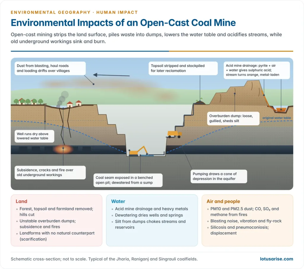
- Scarification: open pits, benches, overburden dumps, tailings ponds and voids create landforms with no natural counterpart. In 2018 the Supreme Court was told that 31 hills of the Aravalli in Rajasthan had disappeared through illegal mining.
- Overburden: for every tonne of coal, open-cast mines remove several tonnes of rock and soil. Loose dumps are unstable, slide in heavy rain and shed sediment into streams.
- Loss of topsoil and forest: stripping the topsoil, which took centuries to form, ends the land’s productivity unless it is stored and returned.
- Mining is a leading cause of forest diversion in central India; the Hasdeo Arand forests of Chhattisgarh are a current flashpoint.
- Subsidence: the ground sinks over underground workings as roofs and pillars fail, cracking houses, roads and railway lines (Jharia, Raniganj).
- Mine fires: coal seams exposed to air ignite spontaneously and burn for decades.
Water
- Acid mine drainage (AMD): when sulphide minerals such as pyrite in coal and metal ores meet air and water, they oxidise to sulphuric acid and dissolved iron.
- The acid leaches heavy metals (arsenic, cadmium, lead, mercury) from rock, and iron precipitates as orange “yellow boy” on stream beds.
- AMD can continue for centuries after a mine closes. Rivers in the Jaintia Hills of Meghalaya, such as the Lukha and Kopili, have turned acidic below rat-hole coal mines.
- Groundwater drawdown: pits are dewatered by continuous pumping, creating a cone of depression that dries village wells and springs kilometres away.
- Siltation: bare dumps and haul roads raise sediment loads.
- Iron-ore mining at Kudremukh in the Western Ghats silted the Bhadra river until the Supreme Court ordered mining to stop by the end of 2005.
- Coal mining in the Damodar valley silts its reservoirs.
- Tailings dams: fine waste from ore processing is stored as slurry behind earth embankments; their failure is catastrophic.
- Mariana (Brazil), November 2015 and Brumadinho (Brazil), January 2019 (about 270 deaths) buried rivers and towns under iron-ore tailings.
- Coastal and estuarine damage: ore transport by barge and port handling, as in Goa’s Mandovi and Zuari estuaries, spreads fines and metals.
Air, noise and climate
- Dust: blasting, crushing, haul roads and loading raise particulate matter (PM10 and PM2.5), a chronic air pollution problem in mining towns such as Dhanbad, Singrauli and Korba.
- Coal fires release carbon dioxide, carbon monoxide, sulphur dioxide and toxic hydrocarbons; coal-bed methane escapes from seams.
- Smelters and thermal plants that cluster around mines add sulphur dioxide, fly ash and mercury.
- Blasting causes ground vibration, noise and fly-rock, damaging nearby houses.
Biodiversity
- Habitat loss and fragmentation: mines and their roads, railways and conveyor belts cut through forests and wildlife corridors, especially elephant routes in Odisha, Jharkhand and Chhattisgarh. This drives human–elephant conflict.
- Western Ghats and Aravallis: mining in these hills removes endemic-rich forests and the natural barrier against desert spread towards the Indo-Gangetic plains.
- Rivers: acid, metals and silt kill aquatic life; sand mining destroys the habitat of gharials in the Chambal and turtle nesting beaches.
Health and society
- Occupational disease: silicosis among sandstone and stone-quarry workers (Rajasthan adopted a pneumoconiosis policy in 2019), coal workers’ pneumoconiosis, asbestosis.
- Community exposure: dust, polluted water and radiation concerns around uranium tailings at Jaduguda (Jharkhand).
- Displacement and the “resource curse”: mineral-rich districts of central India are among the poorest. Benefits leave the region while costs stay, a pattern that has fed alienation and conflict.
- Indigenous consent: Niyamgiri (Odisha): in 2013 the Supreme Court left the decision on bauxite mining in the Niyamgiri hills to the gram sabhas of the Dongria Kondh. All the gram sabhas rejected the project, a landmark for the Forest Rights Act.
Beyond the mine: processing, use and other earth resources
- Beneficiation and smelting create their own waste streams.
- Red mud, the caustic residue of alumina refining, is stored in large ponds; the Ajka (Hungary) red-mud spill of 2010 flooded villages, and the Lanjigarh refinery’s ponds in Odisha raised similar fears.
- Fly ash from coal power is held behind ash dykes; the Sasan ash-dyke breach at Singrauli (April 2020) swept slurry over fields and killed several people.
- Oil and gas: spills, blowouts and flaring. The Baghjan gas-well blowout (Tinsukia, Assam, 2020) burned for months beside the Dibru-Saikhowa National Park and the Maguri-Motapung wetland.
- Use of fossil fuels is the largest implication of all: their burning drives climate change, acid rain and urban smog, far beyond the mining districts.
- Groundwater mining: pumping beyond recharge, as in Punjab, Haryana and western Rajasthan, lowers water tables, causes land subsidence and draws up geogenic arsenic and fluoride.
- Positive side: economic geology also guides safe siting of dams, tunnels and waste repositories, groundwater prospecting and mine reclamation, so it is part of the solution as well as the problem.
Coal fires and subsidence: Jharia
- Jharia coalfield (Dhanbad, Jharkhand) holds India’s main reserve of prime coking coal. Underground fires have been reported there since 1916.
- Causes: old unscientific workings, spontaneous combustion of coal exposed to air, and open-cast mining that let air into burning seams.
- Effects:
- Subsidence, cracks venting hot gases, collapse of homes and roads;
- air pollution (carbon monoxide, sulphur dioxide, particulates) and respiratory disease;
- loss of a non-renewable coking-coal resource.
- Response: the Jharia Master Plan (2009) for fire control and resettlement moved slowly. In June 2025 the Union Cabinet approved a revised Jharia Master Plan of ₹5,940.47 crore.
- It handles the most vulnerable sites first and gives each family a livelihood grant of ₹1 lakh plus access to credit, alongside resettlement colonies.
- Chasnala (1975): water from old flooded workings burst into an active mine near Dhanbad and killed 375 miners, a reminder of the hazards of abandoned workings.
Sand and stone mining
- Sand and gravel are the most used natural resource after water. Construction demand makes illegal sand mining a large, often violent, unregulated trade.
- Effects of riverbed sand mining:
- lowering of the riverbed and headward erosion, undermining bridges and embankments;
- falling riverside water tables, because sand beds store and recharge groundwater;
- bank collapse, loss of fish breeding grounds and turtle and gharial nesting sites;
- coastal erosion when sand supply to the coast falls. Mineral-sand mining along Chavara–Alappad (Kollam, Kerala) is linked to severe shoreline loss.
- Kerala rivers such as the Periyar and Bharathapuzha have deepened sharply through sand mining, and the Chambal sanctuary faces illegal extraction.
- Regulation:
- The Sustainable Sand Mining Management Guidelines, 2016 made a District Survey Report the first step before any lease.
- The Enforcement and Monitoring Guidelines for Sand Mining, 2020 add replenishment studies, no riverbed mining in the monsoon, drone surveillance (including at night), source-to-destination tracking, online sales and district task forces. Where the two conflict, the 2020 guidelines prevail.
- Stone quarrying in the Aravallis, the Western Ghats and around cities flattens hills, lowers aquifers and fills the air with silica dust.
Indian mining case studies
| Region | Mineral | Problem | Judicial or policy response |
|---|---|---|---|
| Goa | Iron ore | Illegal and excess extraction; silted rivers and estuaries; dried springs; dust | Supreme Court halted mining (October 2012); reopened with a 20-million-tonne annual cap (2014); 88 lease renewals quashed (February 2018) and mining stopped; auctioned blocks began reopening from 2024 |
| Bellary (Karnataka) | Iron ore | Illegal mining and export boom; forest loss; dust; damaged roads and farms | Supreme Court ban (2011) after Lokayukta and expert reports; phased resumption under production caps and reclamation plans |
| Aravalli (Haryana, Rajasthan) | Stone, marble, silica sand | Hills removed, aquifers lowered, dust, desert spread | Ban in Haryana’s Aravallis (2009); Supreme Court accepted a 100-m height definition of Aravalli hills (20 November 2025), then kept it in abeyance and set up a new expert committee (29 December 2025); centre barred new mining leases across the range (24 December 2025) |
| Meghalaya (Jaintia Hills) | Coal (rat-hole) | Acid streams, unsafe mines, land damage | National Green Tribunal ban (2014); Ksan mine flooding (December 2018) trapped 15 miners |
| Kudremukh (Karnataka) | Iron ore | Silting of the Bhadra, loss of shola–grassland in a national park | Supreme Court ordered mining to end (2005) |
| Niyamgiri (Odisha) | Bauxite | Sacred hill of the Dongria Kondh; forest and streams | Gram sabhas rejected mining (2013) under the Supreme Court’s order |
| Jharia (Jharkhand) | Coking coal | Fires, subsidence, air pollution | Jharia Master Plan (2009), revised (2025) |
Towards Sustainable Dams and Mining
Solutions for large dams
- Before building:
- Comprehensive options assessment: compare the dam with alternatives such as watershed treatment, tanks, groundwater recharge, demand management and smaller run-of-river schemes.
- Rigorous environmental impact assessment, with cumulative basin studies for cascades of dams (Alaknanda, Bhagirathi, Teesta, Siang) rather than one project at a time.
- Avoid protected areas, high seismic and glacial-hazard zones and the last free-flowing rivers.
- Design and operation:
- Environmental flows that mimic the natural flood pulse; multi-level outlets that release oxygenated water.
- Sediment management: catchment treatment, sediment sluicing and flushing, bypass tunnels.
- Fish passes, hatcheries and protection of key spawning tributaries.
- Integrated reservoir operation with flood forecasting, so that releases are planned before a storm.
- People:
- Land-for-land resettlement, livelihood restoration and benefit sharing (a share of power revenue to affected villages).
- Free, prior and informed consent of Adivasi communities.
- Safety: implement the Dam Safety Act: instrumentation, inspections, emergency action plans, dam-break flood mapping and warning systems downstream.
- Existing and obsolete dams: retrofit fish passes and outlets, and decommission unsafe or useless dams.
- The Elwha (2011–14) and Klamath (completed 2024) removals in the USA restored salmon runs and sediment supply.
Solutions for mining
- Law and governance:
- The Mines and Minerals (Development and Regulation) Act, 1957 is the core law. The environmental legislation around it covers clearances, forests, water and air.
- Prior environmental clearance under the EIA Notification 2006 (Category A or B by size), forest clearance under the Van (Sanrakshan Evam Samvardhan) Adhiniyam, and gram sabha consent under the Forest Rights Act.
| MMDR amendment | Main changes |
|---|---|
| 2015 | Auction made mandatory for leases; 50-year leases; District Mineral Foundation (DMF) and National Mineral Exploration Trust created; stiffer penalties for illegal mining |
| 2021 | Captive and merchant mine distinction removed; captive mines may sell up to 50% of output; clearances transfer to new lessees |
| 2023 | Exploration licences for deep-seated and critical minerals; Centre to auction critical and strategic minerals; six minerals (including lithium) removed from the atomic minerals list |
| 2025 | Exploration trust widened into a National Mineral Exploration and Development Trust; lease area may be extended for deep-seated minerals; critical minerals may be added to existing leases |
- Sharing benefits with affected people:
- District Mineral Foundations receive 30% of royalty from leases granted before 12 January 2015 and 10% from auctioned leases.
- By January 2025, 645 DMFs had collected about ₹1.04 lakh crore, but actual spending was only about ₹56,000 crore.
- The Pradhan Mantri Khanij Kshetra Kalyan Yojana (PMKKKY), revised in 2024, requires at least 70% of DMF funds to go to high-priority sectors: drinking water, environmental protection and pollution control, health, education, livelihoods and sanitation.
- Weaknesses: idle funds, spending on urban infrastructure instead of affected villages, and little say for affected people.
- Mining practice:
- Progressive mine closure plans, with financial guarantees, so that reclamation proceeds while mining continues rather than after it ends.
- Topsoil stripping and storage, concurrent backfilling of worked-out pits, regrading of dumps and revegetation with native species.
- Dust control (water sprinklers, covered conveyors, surface miners that cut instead of blasting) and green belts.
- Mine-water treatment and reuse; neutralisation and capping of sulphide wastes against AMD.
- Fire control by trenching, blanketing and inert-gas injection; resettlement from unstable ground.
- Star rating of mines under the Ministry of Mines’ sustainable development framework rewards good practice.
- Ecological restoration: reclaimed pits and dumps are converted into lakes, forests and eco-parks, a form of ecosystem restoration under the UN Decade (2021–2030).
- No-go and limits: keep mining out of ecologically sensitive zones (parts of the Western Ghats, the Aravallis, dense forests and wildlife corridors), cap output to carrying capacity as in Goa, and enforce sand-mining guidelines with technology.
- Demand side: recycling of metals, construction and demolition waste and manufactured sand reduce pressure on new extraction. The energy transition will lower coal demand but raise demand for critical minerals.
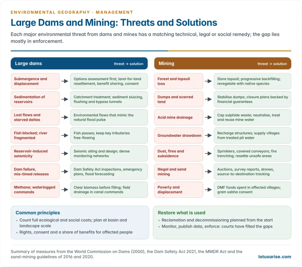
Evaluation
- Dams and mines are neither inherently good nor bad. Their net value depends on site, scale, design and who decides.
- A well-sited, well-run reservoir can serve millions for a century; a badly sited one can silt up, fail or impoverish whole valleys.
- Common lessons from both:
- Count the full costs: ecological, social and long-term risks, not just engineering and money.
- Plan at the basin and landscape scale, not project by project.
- Give affected communities rights, consent and a share of benefits.
- Restore what is used: reclamation and decommissioning belong in the plan from the start.
- In an era of climate change (more extreme rain, glacial-lake outbursts, shifting river flows) and a critical-minerals rush, the precautionary and sustainable-development principles matter more, not less.
Previous Year Questions
2026Construction of large dams poses serious challenges. Describe the threats and solutions associated with it.2023What are the environmental implications of economic geology? Discuss.2021Discuss the ecological and economic challenges of river linking in India.2019“Intrabasins linkages of rivers are more feasible economically, socially and ecologically”. Discuss with suitable examples from India.2017Interlinking of rivers may serve as a major source of assured irrigation and all-weather inland navigation in India. Comment on its feasibility taking into account physical, economic and ecological implication.2012Discuss how different types of mining lead to different types of environmental problems.




