

- Environmental Impact Assessment (EIA) is the systematic procedure for identifying, predicting, evaluating and mitigating the likely consequences of a proposed project before the decision to build it is taken.
- Every large project, whether a dam, highway, mine, port, thermal plant or metro, can permanently alter ecosystems, displace communities and use up natural capital that took millennia to build.
- EIA brings these consequences into view while the design can still change.
- EIA is at once a technical instrument and a democratic process.
- As a technical instrument it draws on ecology, hydrology, atmospheric science and socio-economics to forecast and quantify environmental change.
- As a democratic process it gives affected communities, civil society and government agencies a structured chance to scrutinise a project and hold decision-makers to account.
- Core purpose: to ensure that development does not damage the ecological functions and productivity of natural systems, or the living standards of the people who depend on them.
- It is one of the main working tools of environmental management and of the sustainable development agenda set out in Our Common Future, the report of the Brundtland Commission (1987).
Concept, Objectives and Principles of EIA

Meaning and definitions
- EIA is usually described as an assessment of the impacts of planned activities on the environment: land, water, air, flora, fauna and people.
- It aims not only to reduce harm but also to find ways for a project to make a positive contribution to the environment and human well-being.
- International Association for Impact Assessment (IAIA, 1999): EIA is “the process of identifying, predicting, evaluating and mitigating the biophysical, social, and other relevant effects of development proposals prior to major decisions being taken and commitments made.”
- Espoo Convention (UNECE, 1991): EIA is “a national procedure for evaluating the likely impact of a proposed activity on the environment.”
- Impact means the change in an environmental parameter, over a given period and area, that results from an activity, compared with what would have happened without the project.
- For example, a new thermal plant raises sulphur dioxide levels. The impact is not the extra gas itself but its effect on human health, crops, forests and other parts of the ecosystem.
EIA in four dimensions
| Question | Answer |
|---|---|
| What is EIA? | A process, a decision-making tool, a part of project planning and a way of addressing environmental concerns |
| Why is it needed? | Mines, dams, roads, tourism and industry cause deforestation, water depletion, habitat loss and displacement; prediction matters as resources shrink |
| What does it produce? | An Environmental Impact Statement (EIS) or EIA report, with an Environmental Management Plan (EMP), which guides approval, modification or rejection |
| What makes it sound? | Coverage of all project phases, public and stakeholder input, reliable data, accepted methods, plain language and monitoring after approval |
| What is related to it? | Strategic Environmental Assessment (SEA) of policies and plans; Integrated Environmental Assessment (IEA) of environment–society interactions; Social Impact Assessment (SIA) |
Objectives of EIA
- Integrate environment into decisions: make sure environmental considerations are explicitly addressed in development decisions, alongside cost and engineering.
- Anticipate and avoid harm: foresee and minimise adverse effects before a project is set in motion. Preventing damage is cheaper than repairing it.
- Protect natural productivity: safeguard the productivity and capacity of natural systems and the ecological processes that keep them working.
- Promote sustainable resource use: favour development that optimises the use and management of land, water, energy and materials.
- Ensure compliance with local, national and international law throughout the project’s life.
- Inform decision-makers with objective, up-to-date data so they can approve, amend or reject a proposal.
Scope of EIA
- The scope varies with the project, its location and the applicable law. A full assessment normally covers these components:
- Project description: goals, scale, setting and phases (construction, operation, decommissioning).
- Baseline: the existing state of air, water, land, biota and society, against which change is measured.
- Impact identification and prediction: environmental, social and economic effects, positive and negative, short- and long-term.
- Analysis of alternatives: other sites, designs, technologies and the “no-project” option.
- Mitigation: design changes, technology and management steps that avoid, reduce or offset harm and strengthen benefits.
- Cumulative effects: how the project interacts with other existing and planned projects in the same ecosystem or basin.
- Public participation: hearings, consultations and written comments.
- Reporting: the EIS and its non-technical summary, submitted to the regulator and made public.
- Monitoring and compliance: follow-up through the whole life cycle of the project.
The environment as EIA sees it
- For assessment, the environment is treated as a composite of three domains:
| Domain | Components |
|---|---|
| Physical | Geology, terrain, soils, climate, surface and groundwater, air quality, noise |
| Biological | Terrestrial and aquatic ecosystems, rare and endangered species, sensitive habitats, protected areas |
| Socio-cultural | Population, land use, livelihoods, goods and services, public health, recreation, heritage and customs |
- Impacts are classified along several axes. A good assessment states each axis for every significant impact:
- Nature: beneficial or adverse.
- Order: direct (primary) impacts, such as the forest cleared for a reservoir; and indirect (secondary or higher-order) impacts, such as the malaria that follows standing water.
- Duration and reversibility: short- or long-term; reversible or irreversible (an extinct species, a drowned valley).
- Extent: local, regional or global.
- Combination: cumulative (the sum of many small projects) and synergistic (effects that interact to exceed their sum).
- Probability: certain, likely or unlikely; low-probability, high-damage events such as dam failure need separate risk assessment.
Four approaches of EIA
| Approach | What it does |
|---|---|
| Aid to decision-making | Gives unbiased evidence on ecosystems, biodiversity, air, water and society; does not dictate an outcome but frames the risks and benefits of each option |
| Formulation of development actions | Shapes the project itself by testing alternatives of site, design and technology and choosing the least damaging |
| Stakeholder consultation | Provides a forum for communities and interest groups through disclosure, hearings and dispute resolution |
| Instrument of sustainable development | Balances economic, social and environmental goals, so that development follows sustainability principles |
- Unlike a pollution standard, EIA does not fix an environmental outcome in advance.
- It places the responsibility on decision-makers to choose wisely on the basis of evidence and public input.
- It is therefore a procedural tool: its strength depends on how honestly it is done and how seriously its findings are used.
Principles of EIA
- EIA rests on two sets of principles: basic principles, which apply throughout, and operating principles, which set out the sequence of steps.
Basic principles
- Systematic and comprehensive: cover every likely impact, from air and water to culture and health.
- Early integration: begin at the pre-feasibility and design stage, when changes are still cheap.
- Transparent and participatory: the public must have access to information and a real chance to comment.
- Consideration of alternatives, including the “no-action” alternative.
- Cumulative effects: account for the combined effect of several projects on one area.
- Precautionary and predictive: forecast the state of the environment with and without the project, and lean towards caution where the science is uncertain.
- Multidisciplinary: draw on ecologists, hydrologists, sociologists, air-quality and heritage specialists.
- Enforceable recommendations: mitigation must be practical and must name who carries it out.
- Independent review to keep the process impartial and credible.
- Adaptive: continue monitoring and adjust management as new information arrives.
Operating principles: the steps of an EIA
- Screening: decides whether an EIA is needed and at what level (none, rapid or comprehensive).
- Scoping: identifies the key issues, study boundaries and alternatives, and sets the terms of reference (ToR).
- Baseline study and impact analysis: describes existing conditions and predicts the nature, magnitude, extent and duration of impacts.
- Mitigation and impact management: proposes measures and an Environmental Management Plan.
- Evaluation of significance: judges the residual impacts that cannot be mitigated, using criteria and thresholds.
- EIS or EIA report: documents findings, alternatives, mitigation and public input for the authority and the public.
- Review and decision: an expert body checks the report’s adequacy against the ToR, and the authority approves with conditions or rejects.
- Follow-up: monitoring, compliance and audit once the project is built.
- Public participation runs alongside every step, from scoping to follow-up, and is formally anchored in the public hearing.
- The process is iterative, not a straight line: findings at the impact-analysis stage often send the proponent back to redesign the project or rethink the site.
History and the Indian Framework of EIA
Global evolution
- EIA grew out of mid-twentieth-century concern over the environmental costs of rapid industrial growth.
- The turning point was the US National Environmental Policy Act (NEPA) of 1969, signed into law on 1 January 1970.
- Its Section 102(2)(C) required every federal agency to prepare a detailed Environmental Impact Statement (EIS) for “major Federal actions significantly affecting the quality of the human environment”.
- It created the Council on Environmental Quality (CEQ) and made EIA the world’s first statutory environmental review.
- NEPA today: the model is being narrowed in its home country.
- The Fiscal Responsibility Act, 2023 set page limits and deadlines for EIS preparation.
- CEQ withdrew its own NEPA regulations in 2025.
- In Seven County Infrastructure Coalition v. Eagle County (May 2025), the US Supreme Court told courts to defer to agencies on the scope of review and held that upstream and downstream projects need not be analysed.
| Year | Milestone | Significance |
|---|---|---|
| 1969 | US NEPA | First statutory EIA; the EIS is born |
| 1972 | Stockholm Conference; UNEP founded | Environment enters international policy |
| 1985 | European Community EIA Directive (85/337/EEC) | EIA made compulsory across member states |
| 1987 | Brundtland Report, Our Common Future | EIA endorsed as a tool of sustainable development |
| 1991 | Espoo Convention (UNECE) | First treaty on EIA in a transboundary context |
| 1992 | Rio Declaration, Principle 17; Agenda 21 | EIA accepted as a national instrument for activities likely to cause significant harm |
| 1998 | Aarhus Convention | Public access to information and participation made a right |
| 2001–03 | EU SEA Directive (2001/42/EC); Kyiv SEA Protocol (2003) | Assessment extended upwards to plans and programmes |
| 2018 | World Bank Environmental and Social Framework in force | Ten Environmental and Social Standards for all Bank-financed projects |
- The Rio Earth Summit (1992) was especially consequential. With the Espoo and Aarhus conventions it helped make EIA standard practice in most countries by the early twenty-first century.
EIA in India
Legal basis and institutions
- In India the first environmental appraisal began with river-valley projects in 1976–77, when the Planning Commission asked the Department of Science and Technology to examine them from the environmental angle.
- Clearance then remained an administrative requirement until 1994.
- The statutory basis is the Environment (Protection) Act, 1986: its Section 3 and Rule 5 of the Environment (Protection) Rules empower the Centre to restrict the location of industries and the conduct of operations. The EIA notifications are issued under these powers.
- This umbrella Act sits beside the sectoral statutes that the environmental legislations of India comprise: the Wildlife (Protection) Act, 1972; the Water Act, 1974; the Forest (Conservation) Act, 1980 (renamed the Van (Sanrakshan Evam Samvardhan) Adhiniyam in 2023); and the Air Act, 1981.
- Who does what:
- Regulator: the Ministry of Environment, Forest and Climate Change (MoEFCC) for Category A projects, and the State Environment Impact Assessment Authority (SEIAA) for Category B.
- Appraisal: the central Expert Appraisal Committees (EACs) and the State Expert Appraisal Committees (SEACs).
- Public hearings: the State Pollution Control Boards (SPCBs). The Central Pollution Control Board is not the EIA regulator.
- Applications: since 2018 they move through the single-window PARIVESH portal.
EIA Notification, 1994
- Issued on 27 January 1994, it made prior environmental clearance compulsory for 29 categories of projects listed in Schedule I.
- These included nuclear power, river-valley projects, ports, harbours and airports, petroleum refineries and pipelines, chemical fertilisers, pesticides, mining and thermal power.
- Public hearings were added in 1997. The notification was amended more than a dozen times before 2006, sometimes to tighten it and often to exempt.
- Weaknesses that led to its replacement: all appraisal was centralised in Delhi, there was no screening or scoping stage, and investment thresholds let many damaging projects escape.
EIA Notification, 2006: the current framework
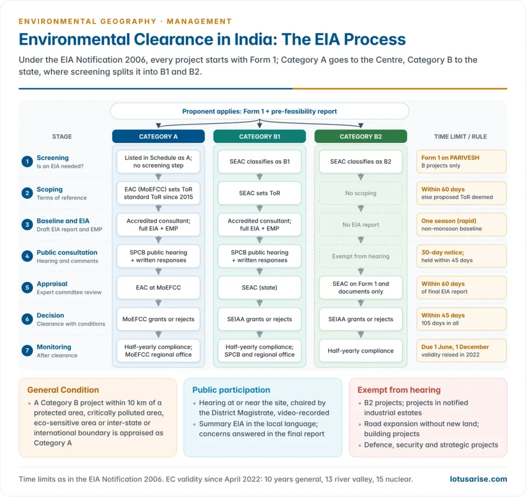
- Notified on 14 September 2006, it re-engineered the process and decentralised it to the states.
- Projects in the Schedule fall under eight broad heads: mining and power, primary processing, materials production, materials processing, manufacturing, services, physical infrastructure, and building and area development.
- Categories:
- Category A: larger projects with wider impacts, appraised by the EAC and cleared by the MoEFCC.
- Category B: smaller projects, appraised by the SEAC and cleared by the SEIAA. At screening they are split into:
- B1, which need a full EIA report and a public hearing;
- B2, which need neither.
- General Condition: a Category B project is treated as Category A if it lies wholly or partly within 10 km of a protected area, a critically polluted area notified by the CPCB, a notified eco-sensitive area, or an inter-state or international boundary.
| Project or activity | Category A (MoEFCC) | Category B (SEIAA) |
|---|---|---|
| Mining of minerals | Lease area 50 ha or more (as notified in 2006) | 5 ha to below 50 ha; minor-mineral leases up to 5 ha brought in from 2016 |
| River-valley (hydroelectric) | 50 MW or more | 25 MW to below 50 MW |
| Cement plants | 1.0 million tonnes per annum or more | Below 1.0 million tonnes per annum |
| Chemical fertilisers | All except single super phosphate | Single super phosphate |
| Highways | New national highways; large expansions of national highways | New state highways; large expansions of state highways |
| Chlor-alkali | 300 tonnes per day or more, or outside a notified industrial area | Below 300 tonnes per day and inside a notified industrial area |
| Leather and hide processing | New or expanding units outside a notified industrial area | New or expanding units inside one |
| Coal washeries | Throughput of 1 million tonnes per annum or more | Below 1 million tonnes per annum |
- Category A irrespective of size: offshore and onshore oil and gas exploration and production, nuclear power and nuclear fuel processing, petroleum refining, asbestos milling, soda ash, petrochemical complexes, ship-breaking yards and oil and gas pipelines passing through national parks and other sensitive areas.
- Thresholds have shifted over time, mostly upwards, through amendments, so the current Schedule must be read with its amendments.
- For example, expansion of national highways now needs prior clearance only above 100 km with extra right of way or land acquisition.
Stages of environmental clearance under the 2006 Notification
- Stage 1: Screening (Category B only). The SEAC examines the application in Form 1 and classifies the project as B1 or B2.
- Stage 2: Scoping. The EAC or SEAC sets the terms of reference for the EIA within 60 days of Form 1.
- If it fails, the applicant’s proposed ToR are deemed approved. Sector-wise standard ToR were issued in 2015.
- The proponent’s accredited consultant then gathers baseline data, normally for one season other than the monsoon: a rapid EIA. A comprehensive EIA covers a full year.
- The consultant prepares the draft EIA report with an EMP.
- Stage 3: Public consultation. It has two parts:
- a public hearing at or near the site, held by the SPCB after at least 30 days’ notice, presided over by the District Magistrate or an officer nominated by them, video-recorded and completed within 45 days of the request;
- written responses from others with a plausible stake.
- The proponent must address every material concern in the final EIA report.
- Exempt from public consultation: B2 projects, expansion of roads without further land acquisition, projects inside notified industrial estates, building and construction projects, and projects concerning national defence and security.
- Stage 4: Appraisal. The EAC or SEAC scrutinises the final report and the hearing record within 60 days, in a meeting the proponent may attend, and recommends grant (with conditions) or rejection.
- Decision: the MoEFCC or SEIAA decides within 45 days of the recommendation, which means 105 days from receipt of the final EIA report.
- Validity: under the 2006 text, 5 years for most projects, 10 years for river-valley projects and up to 30 years for mining. Amendments of April 2022 raised these to:
- 10 years for most projects;
- 13 years for river-valley projects;
- 15 years for nuclear projects;
- mining ECs extendable by 20 years beyond the first 30, with a review every five years.
- Post-clearance monitoring: the proponent files half-yearly compliance reports (due 1 June and 1 December). These are public documents, checked by the MoEFCC’s regional offices and the SPCBs.
Key amendments and turning points since 2006
| Year | Change | Effect |
|---|---|---|
| 2016 | District-level authorities (DEIAA and DEAC) for minor-mineral leases up to 5 ha; building projects linked to local building bye-laws | Clearance pushed down to the district level for small mines and buildings |
| 2017 | Notification of 14 March 2017 | One-time, six-month window for projects already running without prior EC to seek clearance with damage assessment and remediation |
| 2020 | Draft EIA Notification 2020 | Proposed a full replacement; never finalised |
| 2021 | Office Memorandum of 7 July 2021 (standard operating procedure for violation cases) | Allowed violators to seek clearance on paying penalties; followed an NGT order of May 2021 |
| 2022 | Validity extended; existing projects allowed up to 50% expansion without a fresh hearing; highways within 100 km of the Line of Control or border of strategic importance exempted | Many ideas of the 2020 draft brought in piecemeal |
The Draft EIA Notification 2020 controversy
- Published in the Gazette on 11 April 2020, during the COVID-19 lockdown, it proposed:
- Post-facto clearance for projects that had started without approval, on payment of penalties;
- notice for public hearings cut from 30 to 20 days;
- Annual rather than half-yearly compliance reports, prepared by proponents alone;
- an expanded B2 list exempt from EIA and hearings, including small hydro, mid-sized irrigation and many highway expansions;
- wide powers for the Centre to declare projects “strategic” and keep information about them out of the public domain;
- violations to be reported only by the government or the proponent, not by the public.
- It drew about 17 lakh (1.7 million) comments, the largest public response to any environmental rule in India, most of them asking that the draft be withdrawn.
- The Delhi High Court ordered its translation into the languages of the Eighth Schedule.
- Status: the 2020 draft was never notified, so the 2006 Notification, as amended, remains in force.
- Several of the draft’s ideas reached the rulebook in pieces through office memoranda and amendments in 2021–22.
Ex post facto clearance and the Supreme Court
- Prior clearance is the heart of EIA. A clearance granted after construction cannot change the site, design or alternatives, so it turns the assessment into a formality.
- The judicial record:
- Common Cause v. Union of India (2017): mining in Odisha without valid EC was illegal, and the Court ordered compensation equal to the full price of the ore extracted.
- Alembic Pharmaceuticals v. Rohit Prajapati (2020): ex post facto EC is “alien to environmental jurisprudence”, but the Court imposed fines instead of ordering closure.
- Pahwa Plastics v. Dastak NGO (2022): a unit that had applied for, and later obtained, ex post facto clearance was allowed to keep running, given the jobs and investment at stake.
- Vanashakti v. Union of India (16 May 2025): a two-judge bench (Justices Abhay S. Oka and Ujjal Bhuyan) struck down both the 2017 notification and the 2021 office memorandum. It called retrospective clearance a “gross illegality” that offends the precautionary principle and Article 21.
- Recall (18 November 2025): a three-judge bench recalled the Vanashakti judgment by 2:1. Chief Justice B. R. Gavai and Justice K. Vinod Chandran formed the majority; Justice Bhuyan dissented. The majority held that the earlier bench had overlooked coordinate-bench rulings, and the matter was reheard.
- Final ruling (29 July 2026): a bench of Chief Justice Surya Kant and Justices Joymalya Bagchi and Vipul M. Pancholi decided the reheard case:
- It upheld the 2017 notification as a valid, one-time and narrowly tailored measure, with a closed eligibility date, central appraisal, and compulsory damage assessment and remediation.
- It quashed the 2021 office memorandum prospectively, as a bare administrative instruction that cannot override the statutory rule of prior clearance.
- Existing clearances stand, but no fresh post-facto applications can be made.
- Where this leaves the law:
- Prior EC is the rule.
- Any future regularisation must come through a statutory notification, confined to exceptional legacy cases of overriding public interest.
- Commercial investment alone cannot justify regularisation.
Methods and Techniques in EIA
- Methodology is the structured set of tools used to identify, predict, evaluate and communicate impacts.
- No single method suits every project. Practitioners combine several, typically:
- a checklist for identification;
- a matrix for interactions;
- a network for indirect effects;
- overlays or GIS for spatial patterns;
- models and indices for quantification.
Criteria for selecting an EIA method
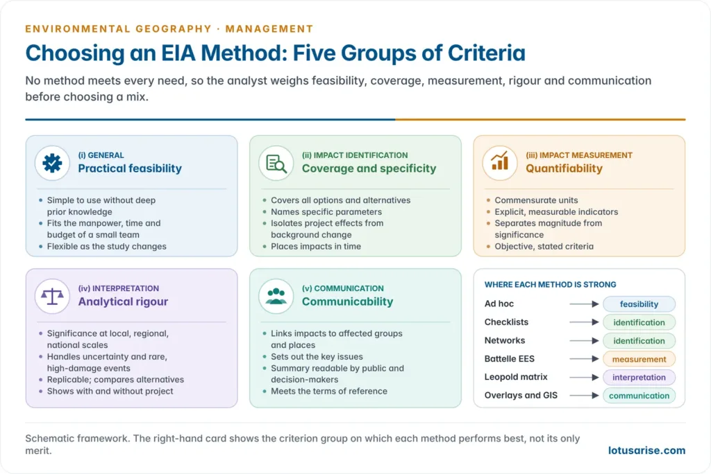
- Every method has strengths and limits, and the analyst’s judgement decides which fits the case. Standard selection criteria fall into five groups:
- General (practical feasibility): simplicity; the manpower, time and budget it needs; flexibility to change as the study proceeds.
- Impact identification (coverage and specificity):
- comprehensiveness across options and alternatives;
- specific parameters for each significant impact;
- isolation of project effects from background change;
- timing and duration.
- Impact measurement (quantifiability):
- commensurate units for comparison;
- explicit, quantifiable indicators;
- separation of magnitude from significance;
- objective, stated criteria.
- Interpretation and evaluation (analytical rigour):
- significance at local, regional and national scales;
- treatment of uncertainty and low-probability, high-damage events;
- replicability by other assessors;
- aggregation of large data sets;
- comparison of alternatives;
- a “with and without project” view.
- Communication (communicability):
- links impacts to the affected groups and places;
- describes the setting;
- sets out the key issues;
- gives a summary that both the public and decision-makers can read;
- shows compliance with the terms of reference.
Ad hoc method
- The simplest approach. A team of experts in each field (air, water, ecology, society) judges impacts from experience and professional opinion, without a formal structure.
- When it is used: under severe time pressure or where scientific data are scarce, as in early screening.
- How it works: each environmental domain is treated separately and impacts are described broadly, for example “significant, adverse, long-term, irreversible”.
| Criterion group | Criterion | Rating |
|---|---|---|
| Cost and time | Expertise, data, time, flexibility | Fully met |
| Cost and time | Personnel effort | Partly met |
| Identification | Comprehensiveness, indicators, discrimination, time and space dimensions | Not met |
| Measurement | Commensurate units, quantification, measuring change, objective criteria | Not met |
| Assessment | Credibility | Partly met |
| Assessment | Replicability | Not met |
- Advantages:
- simple and quick;
- uses experts’ field knowledge directly;
- lists all the main components;
- a reasonable first cut.
- Disadvantages:
- depends wholly on the experts chosen and is not reproducible;
- short- and long-term effects are largely guesswork;
- gives little guidance for systematic analysis;
- cannot organise or interpret complex data.
Checklist methods
- Checklists are structured lists of the environmental, social and economic factors a project may affect. They are more detailed than ad hoc judgement and are the most common tool for impact identification at the scoping stage.
- They range from simple lists to weighted and scaled checklists that assign importance to each factor and calculate scores.
Simple checklist
- A plain list of environmental parameters, with no information on magnitude or importance. It shows which resources are touched by which activity.
| Resource | Site clearance | Earth moving | Foundations | Import of materials | Cumulative |
|---|---|---|---|---|---|
| Air quality | ✓ | ✓ | ✓ | ✓ | |
| Water quality | ✓ | ✓ | |||
| Landscape | ✓ | ✓ | ✓ | ✓ | ✓ |
| Ecology | ✓ | ||||
| Noise | ✓ | ✓ | ✓ | ✓ | ✓ |
| Traffic | ✓ | ✓ | ✓ | ✓ | ✓ |
Descriptive checklist
- Adds background information for each factor, with guidance on how to measure it, the data sources and the prediction techniques.
- It can record past, present and future conditions, which helps in judging cumulative effects.
| Resource | Present impact | Future activity | Cumulative impact |
|---|---|---|---|
| Groundwater | Contamination from industrial use and surface percolation | Excavation would mobilise contaminants | Contamination exceeds standards |
| Air quality | Emissions from an existing power station within standards | New plant adds emissions, also within standards on its own | Combined emissions of the two plants cause a significant impact |
- The air-quality row shows why checklists must look at the sum of projects: each source can pass its own test while together they breach the standard.
Scaling and weighted checklists
- Scaling checklists rate each factor on a subjective scale, commonly 1 to 3 (low, medium, high), separately for beneficial and adverse effects. Factors may include habitat quality, species, abundance, duration and magnitude.
- Weighted checklists go a step further and assign relative weights to factors according to their importance, so that alternatives can be compared on a single score.
- The Battelle Environmental Evaluation System is the classic example.
- Questionnaire checklists put a set of yes/no/unknown questions to the project (“Will the project affect a wetland?”).
- Advantages:
- more structured than ad hoc judgement;
- adaptable to any project;
- links activities to components;
- with weights, allows comparison of alternatives.
- Disadvantages:
- scales and weights remain subjective;
- treats factors one by one, so it misses the links between them;
- does not handle secondary and synergistic effects.
Matrix methods
- A matrix is a grid with project activities on one axis and environmental components on the other. Each cell records whether, how strongly and how importantly an activity affects a component.
- A checklist is one-dimensional: it says only whether an impact occurs. A matrix is two-dimensional: it also shows which activity causes it and how large it is.
- Matrices are the most widely used method for identifying and displaying impacts.
The Leopold matrix (1971)
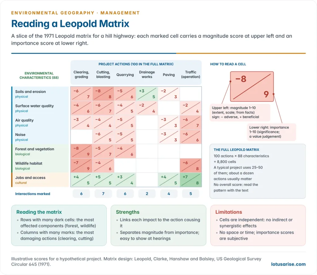
- Devised by Luna B. Leopold, Frank E. Clarke, Bruce B. Hanshaw and James R. Balsley of the US Geological Survey in Circular 645, A Procedure for Evaluating Environmental Impact (1971). It was the first major response to NEPA’s demand for impact statements.
- Structure:
- 100 project actions run along the horizontal axis, grouped as modification of regime, land transformation, resource extraction, processing, waste disposal and so on.
- 88 environmental characteristics and conditions run down the vertical axis, grouped as physical and chemical, biological, cultural, and ecological relationships.
- That gives 8,800 cells. A typical project uses only 25–50 interactions.
- Scoring: in each cell where an interaction is expected, the assessor draws a diagonal slash, then:
- writes the magnitude (degree, extent or scale, judged mainly from facts) from 1 to 10 in the upper left;
- writes the importance (significance, a value judgement) from 1 to 10 in the lower right;
- may prefix a sign to show whether the impact is beneficial (+) or adverse (−).
- Use: the marked cells flag the actions and components that matter. Rows and columns can be summed to find the most damaging actions and the most affected components.
- The matrix gives no single overall score. The numbers are interpreted in the accompanying text.
Other matrix forms
- Phase matrices set project phases (construction, operation, decommissioning) against receptors: water, land, air, flora and fauna, and the human environment.
| Receptor group | Receptors (each scored per phase) |
|---|---|
| Water | Surface hydrology and channel form; surface water quality; groundwater level and quality |
| Land | Landscape character; soils; geology |
| Air | Local air quality; regional and global air quality |
| Flora and fauna | Aquatic ecology; terrestrial ecology |
| Human environment | Socio-economics; health and safety; amenity and nuisance; architectural and archaeological heritage |
- Stepped (cross-impact) matrices set components against components, so that a first-order change (say, in water quality) can be traced to second-order effects (on fish, then on fishing livelihoods).
- Advantages:
- shows the relationship between two sets of factors at a glance;
- can be expanded or trimmed to fit any project;
- separates impacts by phase, and site-specific impacts from regional ones;
- easy to communicate.
- Disadvantages:
- no explicit spatial or temporal dimension;
- treats each cell independently, so indirect and synergistic effects are missed;
- importance scores are subjective, and summing them can mislead;
- large matrices become unwieldy.
Network methods
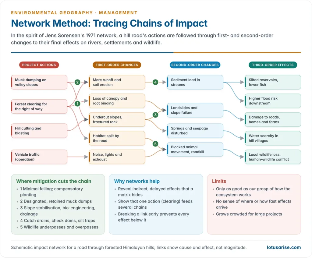
- Networks trace the chain of cause and effect from a project action through first-, second- and higher-order impacts to its final consequences, much as the effects of one change ripple through a food web.
- Jens C. Sorensen (1971) developed the classic Sorensen network at the University of California, Berkeley, for multiple-use planning in the coastal zone.
- It starts from a land use.
- It moves to the causal factors it introduces (dredging, filling, effluent discharge).
- It follows the initial condition changes (turbidity, loss of wetland) to consequent changes (fish decline, loss of nursery habitat) and finally to effects on people (loss of fishing income, recreation, flood protection).
- The layout is an impact tree. Later versions assign a probability and magnitude to each link, so the expected significance of each pathway can be calculated.
- Why networks matter:
- they reveal indirect and delayed effects that matrices hide;
- they show where in the chain mitigation will work best, by cutting a link early;
- they suit ecological systems, where everything is connected.
- Advantages:
- describes the linkages that show how an ecosystem functions;
- displays several levels of information in one diagram;
- takes a holistic view of the cascade set off by one action;
- identifies second- and third-order effects.
- Disadvantages:
- only as good as the understanding of ecosystem relationships, and can oversimplify reality;
- does not show time (how fast the chain runs) or space (where effects land);
- diagrams become crowded for large projects;
- weaker for social, cultural and aesthetic impacts.
Map overlay method
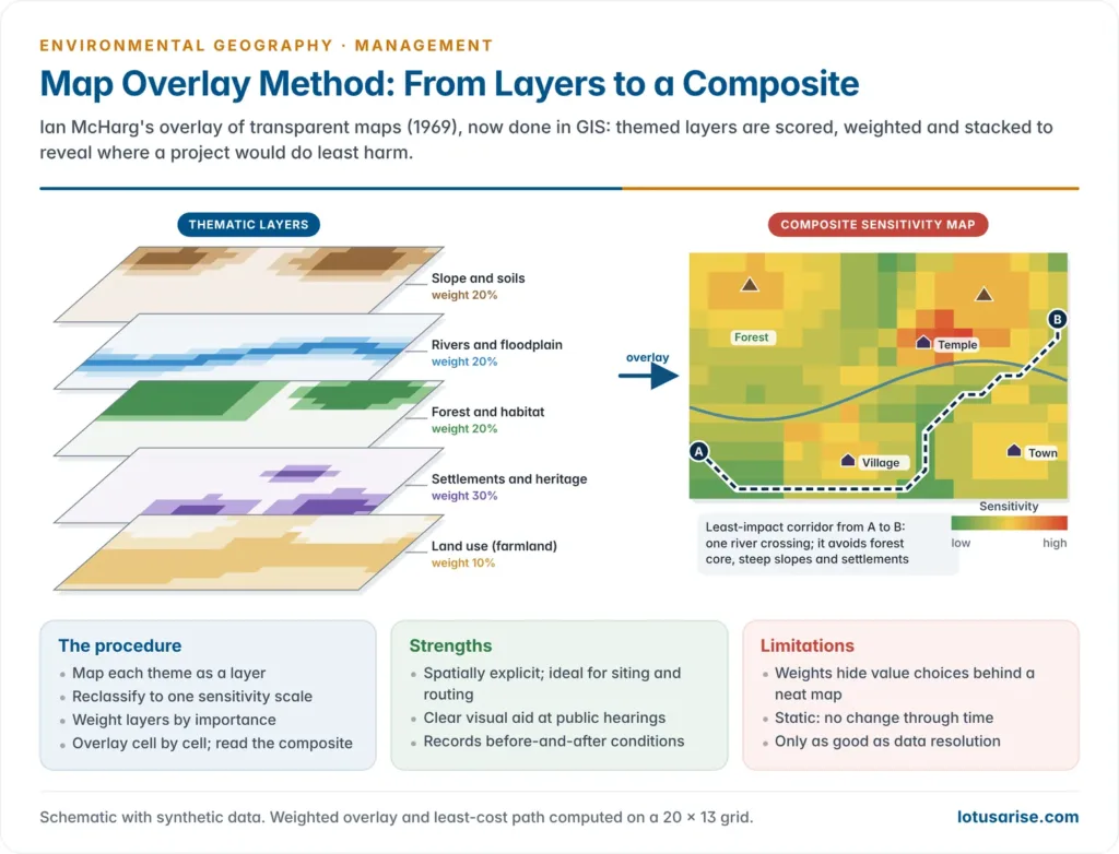
- Pioneered by the landscape architect Ian L. McHarg in Design with Nature (1969).
- He drew each environmental and social characteristic (slope, soils, drainage, forests, wildlife, historic sites, land values) on a transparent map, shaded darker where the land was more sensitive or more valuable.
- Stacking the transparencies produced a composite map in which the lightest areas were the least-cost, least-damaging locations, and the darkest were the ones to avoid.
- He used it to choose highway routes, notably for the Richmond Parkway on Staten Island.
- J. B. Shopley and R. F. Fuggle (1984) later reviewed and systematised it as a standard EIA method.
- GIS has replaced the transparencies.
- The GIS world model breaks the real world into data layers: satellite imagery, elevation (DEM), transport, land use, water features, ecology and habitat, and social data.
- Each layer is reclassified to a common sensitivity scale, weighted by importance and combined cell by cell (weighted overlay or multi-criteria analysis) into a composite impact or suitability map.
- Uses in EIA:
- site and route selection: alignments for roads, pipelines and transmission lines;
- zoning, for example siting industries away from eco-sensitive zones;
- before-and-after comparison;
- showing cumulative pressures across a region.
- Remote sensing supplies the layers and allows land-use change to be monitored after clearance.
- Advantages:
- simple and spatially explicit;
- shading conveys impact intensity at a glance;
- an excellent visual aid for public hearings;
- records environmental conditions before and after a project;
- can combine biophysical and social layers.
- Disadvantages:
- maps can oversimplify complex impacts and hide the weighting choices behind a neat picture;
- specific interrelationships between factors are not easily shown;
- static layers cannot show ecosystem dynamics through time;
- results depend on data resolution and quality.
Quantitative and other methods
Battelle Environmental Evaluation System (1972)
- Developed by N. Dee and colleagues at the Battelle Columbus Laboratories in 1972 for the US Bureau of Reclamation, to evaluate water-resource projects. It is a weighted-checklist index.
- Structure: 78 environmental parameters in four categories, together carrying 1,000 parameter importance units (PIU) distributed by expert (Delphi) judgement:
| Category | Parameters | PIU |
|---|---|---|
| Ecology | 18 | 240 |
| Environmental pollution (water, air, land, noise) | 24 | 402 |
| Aesthetics | 17 | 153 |
| Human interest | 19 | 205 |
| Total | 78 | 1,000 |
- Procedure:
- Measure each parameter.
- Convert it, through a value function, to an environmental quality (EQ) score between 0 (very poor) and 1 (very good).
- Multiply by its PIU to get environmental impact units (EIU = EQ × PIU).
- Compare the totals with and without the project. A net loss signals an adverse impact.
- Red flags mark parameters whose quality changes sharply, even if the totals look acceptable. For ecology, a decline of more than about 10% is a major flag.
- Strengths:
- quantitative and commensurate, so alternatives can be ranked;
- explicit weights;
- replicable.
- Weaknesses:
- data-hungry;
- weights and value functions are still value judgements;
- designed for water projects;
- a single index can mask severe local losses (hence the red flags).
Other techniques
- Cost-benefit analysis (CBA):
- It values impacts in money (lost forest produce, health costs, flood damage avoided) and sets them against project costs and benefits, often through environmental valuation methods such as contingent valuation and travel cost.
- It aids comparison, but struggles with non-market values, irreversibility and the distribution of costs between groups.
- Mathematical and simulation models predict the magnitude of specific impacts:
- Gaussian plume dispersion models for stack emissions;
- hydrological and water-quality models for rivers and reservoirs;
- noise-propagation and groundwater models.
- GIS and remote sensing: land-use and land-cover baselines, habitat mapping, change detection and post-project monitoring.
- Expert systems and Delphi panels: structured rounds of expert opinion to reach consensus on weights or significance where data are lacking.
- Carrying-capacity studies: test whether a region (a hill town, a river basin) can absorb a project without crossing ecological thresholds.
- Environmental risk assessment: for low-probability, high-consequence events such as dam failure or chemical leaks.
- Life-cycle assessment traces impacts from raw material to disposal.
- Environmental audit checks performance after commissioning.
Comparing the methods
| Method | Best at | Main weakness |
|---|---|---|
| Ad hoc | Quick first judgement | Subjective, not reproducible |
| Checklist | Identifying what is affected | Misses links and indirect effects |
| Matrix (Leopold) | Activity–component interactions; magnitude and importance | No space, time or indirect effects |
| Network (Sorensen) | Indirect and higher-order effects | No space or time; crowded for big projects |
| Overlay and GIS (McHarg) | Spatial sensitivity; siting and routing | Oversimplifies; static |
| Battelle EES | Quantitative comparison of alternatives | Data-hungry; weights subjective |
| Cost-benefit analysis | Economic comparison | Non-market and distributional values |
Case Study: EIA and the Delhi Metro
Background
- Delhi, a city with a long recorded history, is now the core of the National Capital Region (NCR). The NCR is a vast conurbation spanning the NCT of Delhi and parts of Haryana, Uttar Pradesh and Rajasthan.
- Congestion and pollution: Delhi had more than one crore (10 million) registered vehicles by 2017, and vehicle exhaust is a leading source of the city’s winter air pollution.
- The Delhi Metro Rail Corporation (DMRC), conceived in 1996 and largely funded through Japanese (JICA) loans, was built as a high-capacity public transport answer to both mobility and pollution.
Scale and growth of the network
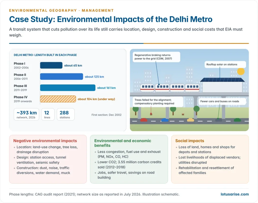
- The first section, Shahdara–Tis Hazari, opened in December 2002. The network has since grown in phases:
- Phase I (about 65 km), completed in 2006;
- Phase II (about 125 km), built in 2006–2011;
- Phase III (about 161 km), built in 2011–2019.
- By 2026 the metro ran about 393 km on 12 lines with 288 stations.
- Phase IV (about 104 km in six corridors) has been under way since 2019 and opens in stages from 2026; later phases are planned to extend the network into the wider NCR.
Environmental clearance status
- Metro rail is not listed in the Schedule of the 2006 Notification, and the MoEFCC has held, including in a 2009 memorandum, that metro projects do not need prior environmental clearance.
- In May 2016 the National Green Tribunal ruled that metro and railway projects must obtain EC on the basis of a proper EIA.
- The Supreme Court stayed that order in September 2016, accepting for the interim the argument that mass transit reduces pollution.
- In practice DMRC still commissions EIA studies and environmental management plans for each phase, because its lenders require them.
- These cover tree felling and compensatory planting under the Delhi Preservation of Trees Act, 1994, noise and vibration, dust, muck disposal, groundwater, and resettlement.
- The case shows a structural gap: exemption by category assumes a project type is benign. Yet even a “green” project has construction-phase and social costs that need assessment.
Environmental and social impacts
| Negative (environmental) | Positive | Social |
|---|---|---|
| Location: land-use change, tree loss on elevated sections, disruption of drainage | Jobs in construction and operation; boost to the local economy | Loss of land for depots and stations |
| Design: layout of station entry and exit, ventilation and lighting of underground sections, seismic safety | Faster, safer, more accessible travel; fewer road accidents | Loss of homes and shops along alignments |
| Construction: dust and noise, health risks at sites, traffic diversions and congestion, heavy water demand | Less congestion and fewer buses and cars on roads | Lost livelihoods for displaced vendors and residents |
| Construction phase: disruption of water supply and sanitation, problems for pedestrians | Lower fuel use and less air pollution (particulates, hydrocarbons, NOx, CO) | Loss of common property resources and public utilities |
| Spoil and muck disposal; groundwater drawdown in tunnelling | Savings on road building; lower CO2 emissions | Rehabilitation and resettlement of affected families |
Cost-benefit logic and carbon credits
- The metro runs on electricity, so it emits no exhaust at the point of use. Its emissions depend on how the grid’s power is generated, which makes rooftop solar and regenerative braking important.
- Every litre of fuel burnt releases roughly 2.7 kg of CO2 for diesel and 2.3 kg for petrol. Shifting commuters from cars and buses to trains therefore cuts both carbon and local pollutants.
- Regenerative braking, in which the train’s motors act as generators while braking and feed power back to the grid, made Delhi Metro, in 2007, the first metro or railway project in the world registered under the Kyoto Protocol’s Clean Development Mechanism (CDM).
- It was also the first metro registered with the Gold Standard (2014).
- It sold 3.55 million carbon credits earned in 2012–2018 for about ₹19.5 crore.
- A model for other cities: Bengaluru, Hyderabad, Mumbai, Pune, Chennai, Kochi, Jaipur and Lucknow have built or are building metro systems on the DMRC model, as part of sustainable urban development.
- Lesson for EIA: a project can be net beneficial over its life and still need careful assessment of its local, construction-phase and social costs. EIA weighs both, rather than assuming the answer from the project type.
Beyond Project EIA: Strategic and Cumulative Assessment
Strategic Environmental Assessment (SEA)
- SEA applies impact assessment upstream, to policies, plans and programmes: a state’s hydropower policy, a river-basin plan, a port-led development programme or a city master plan.
- Why it is needed:
- Project EIA comes too late and too narrow. By the time a single dam is assessed, the decision to dam the river, and how many times, has already been taken.
- SEA tests the alternatives that matter (energy mix, location of growth, demand management) and sets the framework within which project EIAs then work. This is called tiering.
- Legal status:
- Europe: compulsory under the EU SEA Directive (2001/42/EC) and the Kyiv SEA Protocol (2003) to the Espoo Convention.
- India: SEA is not a statutory requirement. It has been tried only in sectoral and donor-supported studies, which is a key gap in environmental issues in regional planning.
Cumulative impact assessment
- Cumulative impacts are the combined effects of a project together with other past, present and reasonably foreseeable activities.
- Each project may be small, but together they can cross an ecological threshold.
- A cascade of run-of-river hydro projects can leave long stretches of a Himalayan river dry, block fish migration and load slopes with tunnels and muck.
- Indian experience:
- After the Kedarnath disaster of June 2013, the Supreme Court (13 August 2013) halted new clearances for hydro projects in Uttarakhand.
- It noted that the cumulative effect of dams, tunnels and blasting on the ecosystem had “yet to be scientifically examined”.
- It ordered an expert re-examination of 24 proposed projects on the Alaknanda and Bhagirathi that the Wildlife Institute of India had flagged.
- The Chamoli flood of February 2021 wrecked the Rishiganga and Tapovan–Vishnugad projects.
- The South Lhonak GLOF of October 2023 destroyed the Teesta III dam at Chungthang in Sikkim.
- Both showed that basin-level hazards are invisible in project-by-project EIA. These are among the high-altitude hazards of fragile mountain systems.
- The MoEFCC now asks for cumulative impact and carrying-capacity studies for river basins with many hydro projects, such as the Teesta, Siang and Lohit. The wider debate on large dams and mining turns on the same point.
- After the Kedarnath disaster of June 2013, the Supreme Court (13 August 2013) halted new clearances for hydro projects in Uttarakhand.
- Salami slicing: splitting a large project into pieces that each fall below the EIA threshold defeats cumulative assessment.
- The Char Dham highway project in Uttarakhand was divided into 53 separate works, each under 100 km, and the government told Parliament in 2023 that no EIA had been required.
EIA and SIA compared
| Dimension | Environmental Impact Assessment | Social Impact Assessment |
|---|---|---|
| Focus | Biophysical and ecological consequences | Human and community consequences of projects and policies |
| Mandate in India | EIA Notification 2006 under the Environment (Protection) Act, 1986 | Right to Fair Compensation and Transparency in Land Acquisition, Rehabilitation and Resettlement (RFCTLARR) Act, 2013 |
| Key output | EIA report or EIS with an EMP | SIA report with a Social Impact Management Plan |
| Typical methods | Checklists, matrices, networks, overlays, models | Consultations, surveys, expert opinion, GIS, matrices |
| Idea of impact | Change in the biophysical environment | The lived experience of social change |
- The two are complementary. EIA’s socio-cultural component overlaps with SIA, but social impact assessment goes deeper into displacement, livelihoods, gender and culture, which a biophysical focus underplays.
- Good practice now joins them as Environmental and Social Impact Assessment (ESIA), as under the World Bank’s framework.
Weaknesses of EIA in practice, especially in India
- Conflict of interest: the proponent pays the consultant who writes the EIA. Reports tend to justify the project, and cases of copied and inaccurate reports have surfaced repeatedly.
- Thin baselines:
- One-season data cannot capture seasonal ecology, monsoon hydrology or migratory species.
- In April 2023 the National Green Tribunal set up a high-powered committee to revisit the clearance for the Great Nicobar project, noting that its baseline covered only one season and that thousands of coral colonies were to be translocated.
- The planning stakes for island territories make such gaps serious.
- Weak public participation:
- hearings held far from affected villages;
- documents in English or unfamiliar languages;
- short notice and intimidation;
- growing exemptions from hearings.
- Exemption and dilution by amendment and office memorandum: expansions without hearings, “strategic” exemptions and post-facto routes. These are now curbed by the 2026 Vanashakti ruling.
- No cumulative or strategic assessment as a matter of law; salami slicing goes unchecked.
- Poor monitoring: compliance reports are self-certified, and the MoEFCC’s regional offices are thinly staffed. Conditions attached to clearances are often not enforced.
- No independent regulator: in Lafarge Umiam Mining v. Union of India (2011) the Supreme Court asked for a national regulator to appraise projects and monitor conditions. It has not been set up.
- Proposed reforms:
- an independent appraisal authority, with consultants paid from a pooled fund rather than by the proponent;
- statutory SEA and basin-level cumulative studies;
- multi-season baselines;
- hearings in local languages near affected communities;
- third-party and community-based monitoring, with compliance data published on PARIVESH;
- proper use of the precautionary and polluter-pays principles that run through India’s environmental policy.
- The geographical lesson: impacts are spatial, cumulative and scale-dependent, so EIA works best when it is tied to regional and basin planning rather than run one project at a time.
Previous Year Questions
- No direct PYQ has been asked on this sub-topic yet.




