

Regional Planning and Development of Island Territories

- In the field of regional development and planning, island territories represent a distinct category of spatial units described as “ipso facto coastal entities” where terrestrial and marine environments are inextricably linked. For a nation like India, with over 1,000 islands, including the strategically vital Andaman & Nicobar and Lakshadweep archipelagos, regional planning and development are crucial for ensuring sustainable growth, economic prosperity, and environmental conservation.
- India’s island landscape is vast, comprising over 1,000 islands, of which 247 are inhabited (204 in the Bay of Bengal and 43 in the Arabian Sea).
- The islands are occupied by the tribal ethnic groups, having their unique primitive cultures. Islands and their beaches are attracting a large number of tourists. The islands, therefore, need a special strategy for their socio-economic sustainable development.
- Unlike mainland regions, island territories face a unique set of constraints characterized by the “tyranny of distance”—a combination of geographic isolation, fragile ecosystems, and limited resources that makes standard developmental models unfeasible. These regions are on the front lines of the climate crisis, facing high susceptibility to rising sea levels, ocean acidification, and frequent natural disasters such as cyclones and tsunamis.
- Consequently, island regions require specialized planning approaches, such as Integrated Coastal Zone Management (ICZM) and the “Ridge to Reef” strategy, which leverage the connectivity between land and sea to build resilience. To transform these territories into resilient “Large Ocean States,” contemporary development strategies must be multi-dimensional. They must effectively address economic diversification through the Blue Economy and sustainable tourism, prioritize infrastructure development that overcomes logistical bottlenecks, ensure stringent environmental protection of endemic biodiversity, and enhance social welfare for indigenous communities and island residents.
Physiographic and Demographic Regionalization
1. Physiographic Regionalisation: Lithological and Geomorphic Origins
- Physiographic regionalisation of Indian islands is primarily determined by their tectonic and lithological origins, which dictate their soil quality, vegetation, and resource potential.
- The Andaman and Nicobar Archipelago (Volcanic/Tectonic Origin)
- Geomorphic Origin: These islands represent the submerged folds of the Arakan Yoma mountain range of Myanmar.
- Regional Divisions: They are broadly divided into the Andaman group (North, Middle, and South) and the Nicobar group.
- Physical Features: The region features granite rocks and peaks, with Saddle Peak in North Andaman being the highest point. Barren Island remains South Asia’s only active volcano.
- Climate and Ecology: These islands possess an equatorial climate characterized by high rainfall and dense tropical rainforests, which support diverse, endemic biodiversity.
- The Lakshadweep Islands (Coral Atolls)
- Geomorphic Origin: These are a group of 36 coral islands formed from the accumulation of coral reefs in the Arabian Sea.
- Regional Divisions: The group is subdivided into the Amindivi islands (North) and the Laccadive and Minicoy islands (South), separated by the 8-degree channel.
- Physical Features: These islands are low-lying and predominantly composed of calcium-rich soil containing organic limestone from dead coral formations.
- Water and Vegetation: Unlike the volcanic islands, these have thin freshwater lenses highly vulnerable to salinisation. The vegetation is primarily scattered palm species.
- Offshore and Coastal Islands
- Estuarine Islands: Sagar Island (Gangasagar) in the Bay of Bengal is a major unit covering ~300 sq. km, serving as a critical habitat for mangrove swamps and the Royal Bengal Tiger.
- Continental Fringe Islands: Numerous smaller islands exist off the coasts of Kathiawad, Mumbai (Salsette), Tuticorin, and the Vedaranyam coast, which are often geologically extensions of the mainland.
2. Demographic Regionalisation: Socio-Cultural and Economic Profiling
- Demographic regionalisation involves classifying islands based on population concentration, the presence of indigenous tribes, and their stage in the Demographic Transition Model (DTM).
- Tribal-Majority Regional Model
- Lakshadweep: This region is a “Tribal Majority” territory where 94.47% of the population belongs to Scheduled Tribes (ST). Planning here follows the “Main Plan” approach, as the entire state plan is essentially a tribal development plan.
- Andaman & Nicobar Indigenous Pockets: While the total ST percentage is lower, specific islands are delineated as Tribal Reserves for the protection of Aboriginal Tribes like the Jarawa, Sentinelese, and Onge.
- Demographic Transition and Vulnerability Analysis
- The demographic profile of island tribes reveals a distinct dualism based on their interaction with the mainstream:
- Stage 1 (High Stationary/Primitive): Groups like the Jarawas and Sentinelese represent very small demographic sizes characterized by high fertility and high mortality. They remain seminomadic and dependent on food-gathering and hunting.
- Stage 5 (Declining/Advanced): In contrast, groups like the Nicobarese have moved toward horticulture and more advanced socio-economic integration, while the Mizos (often used as a comparison in island planning discourse) represent advanced ST groups that have controlled mortality and utilized development benefits.
- The demographic profile of island tribes reveals a distinct dualism based on their interaction with the mainstream:
- Population Pressure and Spatial Distribution
- Coastal Concentration: Most island populations and critical infrastructure (airports, roads) are concentrated in low-lying coastal areas.
- The “Carrying Capacity” Constraint: Small islands like Tidung Besar or many of the inhabited Lakshadweep atolls often exceed their Ecological Carrying Capacity, leading to “buildup” and pressure on limited freshwater and housing resources.
- Isolation and Emigration: Many remote islands face “brain drain” or depopulation as youth migrate to the mainland (or larger administrative centers like Port Blair and Kavaratti) for education and specialized healthcare.
3. Synthesis: The Planning Implication
- From a regional planning perspective, the combination of tectonic instability (volcanic) and low-lying fragility (coral) makes these territories “Problem Regions”.
- Planning must transition from simple infrastructure provision to a “Ridge to Reef” strategy. This involves connecting terrestrial management (afforestation to prevent erosion) with marine management (coral reef preservation) to protect the natural capital that sustains both indigenous livelihoods and the burgeoning tourism sector.
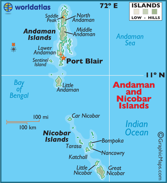
The Union Territory of Andaman And Nicobar
- The population of Andaman and Nicobar island according to census 2011 is 380,581
- There are 556 islands in the union territory of Andaman and Nicobar. Out of these 36 are permanently inhabited.
- Most islands are in the Andaman group, 26 of which are inhabited. The Nicobar Islands comprise 22 main islands (10 inhabited). The Andaman and Nicobar islands are separated by the ten-degree Channel, about 150 km wide.
- The total area of Andaman Islands is about 6408 sq km, and that of Nicobar Islands approximately 1841 sq km.
- The Andaman and Nicobar Islands are endowed with Tropical Rainforest. These forests consist of a mixed flora with elements from Indian, Malaysian, and Myanmarese floral strains.
- So far, about 2200 varieties of plants have been recorded, out of which 200 are endemic and 1300 do not occur in the mainland of India. Andaman forest is rich in timbers species like Gurjan and Padauk.
- About 50 varieties of mammals, 270 varieties of birds, and 225 species of butterflies are found in Andaman and Nicobar. Mount Harriet National park is one of the richest areas of butterfly and moth diversity on these islands.
- The indigenous people of Andaman are:
- The Jarawa,
- The Jangil (or Rutland Jarawa)
- The Onge, and
- The Sentinelese (most isolated of all groups).
- The indigenous people of Nicobar are:
- The Nicobarese, and
- The Shompen
- The indigenous people of Nicobar are restricted to the interior of Great Nicobar.
- A total of 48,700 hectares of land is used for agricultural purposes. Paddy, the main food crop, is mostly cultivated in Andaman group of islands. Coconut and Areca nut are the cash crops. Pulses, oilseeds, and vegetables are also grown.
- There are 1375 small-scale, village, and handicraft units. Two units are export oriented in the line of fish processing activity.
- Moreover, there are shell and wood based handicraft units. There are four mediumsized industrial units.
- The Small Scale Industrial units are engaged in the production of polythene bags, PVC conduit pipes and fittings, paints and varnishes, fibre glass and mini flour mills, and soft drinks and beverages. Small-scale and handicraft units are also engaged in shell crafts, bakery products, rice milling, and furniture making.
- The Andaman and Nicobar islands integrated development corporation is actively busy in the promotion of tourism, fisheries, and industrial financing and functions as the authorised agency for Alliance Air/Jet Airways.
Lakshadweep
- Lakshadweep Consists of 12 atolls, 3 reefs, and 5 submerged banks, with a total of 43 islands, the Lakshadweep is located about 200 to 300 km off the coast of Kerala in the Arabian Sea.
- The total land area of the territory is 32 sq km.; eleven of the islands are inhabited. The main islands are:
- Agatti
- Pitti
- Androth
- Kavaratti
- Kalpeni
- Investigator bank, and
- Minicoy Island.
- Kavaratti is the capital of Lakshadweep. The total population of the territory was 64,473 according to the 2011 census. The islanders are ethnically similar to the coastal Kerala’s Malayalam people, and were influenced by the Arab traders.
- Inhabitants of Minicoy, the Southernmost and largest island, closely resemble Maldivians. Most of the indigenous population (about 99%) is Muslim. The locals call themselves the Div-I or Aminidivi (from the mother island). The people are largely dependent on fisheries, as soils on these coral islands are poor.
- The coral ecosystems of the islands and the scenic appeal of Lakshadweep are attracting the domestic and international tourists in a big way.
- Since such a small region cannot support industries, the government is actively promoting tourism, aquaculture and fisheries. Tourism is one of the important economic activities in these islands. These islands have been recognised as an important ecotourism place of India as a source of income.
- The Agatti Aerodrome on Agatti Island is currently the only airport in the Lakshadweep. Also, from April 2007, a private carrier, kingfisher airlines, has commenced flights to and from Agatti. Kingfisher connects Kochi and Bangalore to Agatti. The other islands are connected by a helicopter and boat service.

Sagar Island
- Sagar Island, also known as Gangasagar, lies on the continental shelf of Bay of Bengal, about 150 km south of Kolkata. The island stretches over 300 sq km and has 43 villages with a population of over 160,000.
- The island is the home to the endangered royal Bengal tiger. It is also rich in mangrove swamps, waterways, and small rivers. This land is a famous Hindu pilgrim place.
- Every year on the day of Makar Sankranti (mid of January), millions of Hindus gather to take a holy dip in the confluence of Ganga and offer puja in Kapil Muni temple. The Kolkata port trust has a pilot station and a lighthouse on this island.
- The government of West Bengal is planning to connect Sagar Island with the mainland with a 3.3 km bridge costing around INR 6,000 million.
- In addition to these, there are a number of islands around Kathiawad, Mumbai, Kochi, Tuticorin, and along the coasts of Tamil Nadu, Andhra Pradesh, Odisha, and West Bengal.


Challenges in Regional Planning of Island Territories
1. The “Tyranny of Distance” and Spatial Constraints
Island regions face structural handicaps that stem directly from their geography and spatial distribution:
- Geographical Isolation: Remoteness from mainland markets and global economic centers significantly increases the cost of imports and exports. This isolation hinders the ability of island regions to create economies of scale, making public administration and infrastructure disproportionately expensive relative to their small population sizes.
- Fragile Ecosystems: Islands are characterized by highly connected terrestrial and marine ecosystems, ranging from volcanic peaks with steep, erosive slopes to low-lying coral atolls with thin, vulnerable freshwater lenses. Their high levels of endemic biodiversity make them ecologically sensitive; a minor land-use change can disrupt key ecological processes and lead to global extinctions.
- Natural Disasters: These territories have a high susceptibility to hurricanes, cyclones, tsunamis, earthquakes, and volcanic activity. Critical infrastructure—such as airports, roads, and tourism facilities—is often concentrated in low-lying coastal areas, leaving it exposed to storm surges and cyclonic waves.
- The Subsistence and Tourism Trap: Many island economies rely heavily on tourism (often accounting for 60–80% of GDP), which is extremely volatile and vulnerable to global economic shocks and environmental disasters. This dependence often displaces traditional subsistence activities like fishing, yet fails to provide long-term economic stability due to its seasonal and external nature.
2. Environmental Challenges
Environmental planning is the most critical aspect of island development due to the direct threat to the physical existence of these territories.
- Climate Change and Rising Sea Levels: Islands are on the “front line” of climate change. Rising sea levels pose an existential threat to settlements and agriculture, particularly in low-lying atolls like Lakshadweep or the Maldives, which face the risk of total submersion. Ocean acidification and marine heatwaves further degrade the coral reefs that act as natural coastal barriers.
- Limited Natural Resources: Narrow resource bases make self-sufficiency nearly impossible. Most islands have limited arable land and minimal mineral deposits. Freshwater scarcity is a pervasive issue, as thin aquifers are highly susceptible to overexploitation, contamination from untreated wastewater, and saltwater intrusion caused by rising sea levels.
- Biodiversity Conservation: While covering less than 0.5% of the world’s surface, SIDS host over 20% of global biodiversity. Planning must balance development with stringent conservation, as 41% of endemic species are currently at high risk of extinction due to habitat fragmentation and the introduction of invasive alien species.
3. Economic Challenges
The economic regionalization of islands often places them in “Problem Regions” due to their inherent lack of diversification.
- Dependence on Tourism: While a major income source, tourism places immense pressure on local energy, water, and waste management systems. The sudden halt of international travel during crises like the COVID-19 pandemic demonstrated the catastrophic impact of this single-sector reliance.
- Limited Industrial Base: Industrialization is constrained by high transportation costs for raw materials and finished goods, as well as high energy costs. Most islands rely on expensive, imported diesel for electricity, lacking grid interconnection to mainlands.
- High Import Dependency: There is a heavy reliance on imports for food, fuel, and manufactured essentials. This dependency leaves island states vulnerable to global price fluctuations and supply chain disruptions, which can quickly lead to food and energy insecurity.
4. Social Challenges
Social planning in island territories must address the unique demographic pressures of isolated communities.
- Population Pressure: High population densities in restricted land areas lead to housing shortages and severe strain on public utilities. In some cases, populations have exceeded the ecological “Carrying Capacity” of the land, leading to environmental collapse and build-up in fragile zones.
- Limited Educational and Health Facilities: Due to geographical isolation, residents often lack access to advanced healthcare and specialized higher education institutions. This results in a significant “Brain Drain” or Human Flight, as highly skilled citizens emigrate to mainlands for better opportunities, leaving the islands with weakened labor forces.
5. Political and Governance Challenges
Effective policy implementation is often hindered by the specialized administrative needs of island territories.
- Governance Issues: Many island regions suffer from decentralized or fragmented governance structures—often described as an administrative “layer cake” where decisions made at national or international levels do not integrate well with local needs. Limited institutional capacity and a lack of technical personnel frequently lead to failures in documenting land rights and managing coastal zones.
- Geopolitical Tensions: Islands often occupy strategic vantage points (e.g., the Andaman Islands’ position over the Malacca Strait), making them focal points for national security and international maritime control. Additionally, disputes over sovereignty and maritime boundaries—particularly regarding Exclusive Economic Zones (EEZ) and deep-sea mining rights—add a layer of geopolitical complexity to regional planning.
Synthesis for Planning
To address these core challenges, regional planning must move toward Integrated Coastal Zone Management (ICZM) and the “Ridge to Reef” approach. These strategies emphasize that land management in islands cannot be separated from marine management, requiring a “Community to Cabinet” governance philosophy that empowers local islanders while leveraging international technical and financial support.
Strategies, Frameworks, and Initiatives for Regional Planning in Island Territories
1. Global and Regional Strategic Frameworks
- The institutionalization of island-specific planning has evolved through several key international milestones:
- 1992 UN Earth Summit (Agenda 21): First recognized SIDS as a distinct group due to their extreme vulnerability to climate change and geographic isolation.
- 1994 Barbados Programme of Action (BPoA): Established the first integrated framework for the sustainable development of small islands, emphasizing technical assistance and coastal watershed management.
- 2014 Samoa Pathway: Accelerated action modalities to address the “Multi-Dimensional Vulnerabilities” of islands, focusing on their role as “Large Ocean States” rather than just small landmasses.
- Eastern Caribbean Planning Framework (2022–2026): A partnership between the Global Green Growth Institute (GGGI) and the OECS to deliver climate action, mobilize green investment, and support green industries in the Caribbean.
2. Integrated Coastal Zone Management (ICZM) Strategies
- ICZM is the primary instrument for island planning, aiming for a rational management of coastal areas by linking land and sea activities.
- Competing Economic Philosophies:
- The French Model: In territories like Guadeloupe and Martinique, coastal zones are viewed as non-market public goods. Planning focuses on coordinating a “mosaic” of public programs and services.
- The Anglo-Saxon Model: Applied in independent Caribbean states (e.g., St. Lucia), this focuses on the economic valuation of natural capital. By quantifying the value of reefs and beaches for tourism, planners prioritize investments based on cost-benefit analysis.
- Ridge to Reef (R2R) Approach: This strategy leverages the connectivity between terrestrial, coastal, and marine ecosystems. It advocates for a “Community to Cabinet” governance philosophy, connecting formal state structures with traditional leadership and local communities.
- Competing Economic Philosophies:
3. Sustainable Environmental Management Initiatives
- Environmental strategies are critical for the physical survival of island territories:
- Coastal Protection: Implementation of nature-based solutions, including mangrove restoration, artificial reefs, and the construction of resilient seawalls to mitigate erosion and rising sea levels.
- Land Degradation Neutrality (LDN): A UNCCD-led strategy to avoid, reduce, and reverse land degradation through integrated land-use planning that balances housing, agriculture, and nature conservation.
- Integrated Water Resource Management (IWRM): Addressing freshwater scarcity through desalination plants, rainwater harvesting, and the protection of thin freshwater lenses from salinization.
4. Economic Diversification and the Blue Economy
- To break the “Subsistence and Tourism Trap,” regional planning seeks to diversify island economies:
- Blue Economy Promotion: Enhancing sustainable fisheries, aquaculture, and marine biotechnology to utilize the vast Exclusive Economic Zones (EEZ).
- Sustainable and Thematic Tourism: Moving beyond mass tourism toward ecotourism and cultural tourism. A key concept here is Tourism Carrying Capacity (TCC), where spatial planning is used to create “thematic zones” (e.g., snorkeling zones, exclusive homestay zones) to prevent ecological buildup and ensure recovery.
- SME and Cottage Industry Support: Promoting local industries such as coconut processing, handicrafts, and agro-processing to generate internal employment.
5. Energy Transition and Infrastructure Initiatives
- Islands face high energy costs due to a reliance on imported diesel. Modern planning focuses on:
- SIDS Lighthouses Initiative (IRENA): A global partnership to accelerate renewable energy deployment. It uses “Quickscans” to assess a SIDS’ readiness for transition and provides “National Energy Roadmaps” to identify least-cost power systems.
- Solar PV and Grid Integration: Large-scale deployment of solar PV combined with Battery Energy Storage Systems (BESS) to cover variability in isolated power grids.
- Digital Connectivity: Expansion of broadband infrastructure to support telemedicine and remote education, bridging the gap caused by geographical isolation.
6. India-Specific Planning Initiatives
- In India, island territories are subject to specialized spatial planning under missions like:
- Integrated Island Management Plans (IIMP): Implemented in the Andaman and Nicobar Islands to promote sustainable fisheries and eco-tourism.
- Dharti Aaba Janjatiya Gram Utkarsh Abhiyan (PM-JUGA): A flagship mission launched in 2024 that targets the saturation of essential services in 63,000 tribal-majority villages, many of which are located in island regions like Lakshadweep. It uses an inter-ministerial approach to bridge gaps in housing, water, and connectivity while respecting tribal cultures.
7. Analytical Planning Tools
- Planners utilize specific toolkits to de-risk investments and structure projects:
- IRENA Project Navigator: An online platform that assists island stakeholders in developing bankable renewable energy project proposals.
- Global Atlas Site Appraisal: A service used to screen sites earmarked for solar and wind development to increase the likelihood of project success.
- GIS Integration: Using Geographical Information Systems to monitor coastline evolution, manage watersheds, and integrate traditional knowledge into spatial databases.
Tribal Area Development in Islands
Tribal area development in island territories represents a specialized branch of regional planning that addresses the needs of indigenous communities living in extreme geographical isolation. In the Indian context, this primarily concerns the Andaman and Nicobar Islands in the Bay of Bengal and the Lakshadweep Islands in the Arabian Sea, where tribal populations face unique vulnerabilities due to their oceanic environment and historical detachment from the mainland.
1. Demographic and Cultural Profile of Island Tribes
The tribal population in India’s island territories exhibits a wide range of developmental stages, from semi-nomadic groups to fully integrated majority populations.
- Andaman and Nicobar Islands: These islands are home to some of the world’s most vulnerable and smallest tribal communities.
- Negrito Tribes (Andamans): The Jarawa, Sentinelese, Onge, and Great Andamanese are semi-nomadic hunting-gathering communities. The Sentinelese, in particular, maintain their way of life through traditional sustainable fishing techniques using arrows and harpoons.
- Mongoloid Tribes (Nicobars): The Nicobarese practice horticulture, while the Shompen remain largely isolated in the interior forests.
- Lakshadweep Islands: Unlike the Andamans, Lakshadweep is a Tribal Majority territory where approximately 94.47% of the population belongs to Scheduled Tribes.
2. Specialized Planning Frameworks
Due to their high tribal concentrations, island territories are governed by distinct planning models that differ from mainland sectoral approaches.
- The “Tribal Main Plan” Approach: In territories like Lakshadweep, where STs constitute the vast majority, the entire state/UT administrative plan is essentially a tribal development plan. There is no need for a separate “Sub-Plan” because the primary goal of all government expenditure is the welfare of the resident tribal population.
- Tribal Reserves and Protective Regulations: In the Andaman and Nicobar Islands, development is secondary to protection. Specific areas are delineated as Tribal Reserves under the Andaman and Nicobar Islands (Protection of Aboriginal Tribes) Regulations (1956 and amendments) to prevent land alienation and unauthorized outside contact.
- Integrated Tribal Development Projects (ITDP): Both Andaman & Nicobar and Lakshadweep (as part of the Daman & Diu/DNH block in some contexts) have designated ITDP units to coordinate specialized services.
3. Core Challenges for Island Tribal Development
Planning in these regions is hindered by the “Tyranny of Distance” and severe ecological constraints.
- Geographical Isolation and Logistics: High travel times to properly equipped hospitals and a reliance on infrequent flights or sea shipping make service delivery disproportionately expensive.
- Vulnerability to Outside Contact: For “Primitive” groups like the Jarawa or Sentinelese, contact with outsiders poses severe health risks (lack of immunity to common mainland diseases) and cultural erosion.
- Ecological Sensitivity: Low-lying atolls like those in Lakshadweep face existential threats from rising sea levels and ocean acidification, which can submerge entire habitats.
- Subsistence Trap: Overcoming a subsistence-based economy without destroying traditional sustainable practices (like the Sentinelese marine resource management) requires delicate “hustle-free” intervention.
4. Contemporary Flagship Missions
Recent government initiatives have shifted toward a “saturation” approach, ensuring that even the most remote island habitations receive essential services.
- PM-JANMAN (2023): This mission specifically targets 75 Particularly Vulnerable Tribal Groups (PVTGs), including those in the Andamans, focusing on providing mobile medical units, clean drinking water, and off-grid solar energy to isolated habitations.
- PM-JUGA (Dharti Aaba Janjatiya Gram Utkarsh Abhiyan, 2024): This ₹79,156 crore mission aims to saturate 63,000 tribal-majority villages (including those in island UTs) with 25 basic interventions like 4G connectivity, pucca houses, and piped water.
- Desalination and Energy: Specific island projects include the development of desalination plants in Lakshadweep to combat freshwater scarcity and investments in renewable energy (solar and wind) to reduce dependence on expensive, polluting diesel imports.
- Van Dhan Vikas Kendras (VDVK): These centers promote value addition for island produce like coconut and tuna, transforming tribal gatherers into entrepreneurs through processing and marketing support.
Way Forward
1. Implementing the “Ridge to Reef” and ICZM Frameworks
The most critical planning instrument for island territories is Integrated Coastal Zone Management (ICZM), which acknowledges that land and sea environments are inextricably linked.
- Ridge to Reef (R2R) Strategy: Future planning should adopt the R2R approach, which leverages the connectivity between terrestrial, coastal, and marine ecosystems to build resilience. This ensures that activities on the “ridge” (inland forests and mountains) do not negatively impact the “reef” (coastal corals and fisheries).
- Economic Valuation of Natural Capital: Planning should shift toward the Anglo-Saxon model of ICZM, which focuses on the economic valuation of goods and services provided by the coastal zone. By quantifying the value of reefs for coastal protection (e.g., avoiding damages estimated at millions of dollars) and beaches for tourism, planners can better justify and prioritize investments in environmental preservation.
2. Diversifying into the Blue Economy
To break the “Subsistence and Tourism Trap,” island regions must diversify their narrow resource bases.
- Sustainable Fisheries and Marine Biotech: Enhancing fisheries in coastal creeks and bays, alongside the development of marine biotechnology, can utilize the vast Exclusive Economic Zones (EEZs) which are often thousands of times larger than the islands’ terrestrial area.
- Formalizing Local Industries: Support for small and medium enterprises (SMEs) in coconut processing, tuna industries, and handicrafts is essential to generate internal employment.
- Deep-Sea Mining Governance: As the industry for seabed minerals like polymetallic nodules emerges, island states must use their Negotiating Position within the International Seabed Authority (ISA) to ensure equitable benefit-sharing and stringent environmental safeguards.
3. Achieving 100% Renewable Energy Transitions
Islands face high energy costs and vulnerability due to a reliance on imported diesel.
- Integrated Renewable Pathways: The way forward involves transitioning to integrated systems combining solar PV, wind, and small-scale hydropower. Because islands lack grid interconnection to the mainland, deployment must prioritize Battery Energy Storage Systems (BESS) to cover variability.
- National Energy Roadmaps: Utilizing tools like the IRENA SIDS Lighthouses Initiative, islands should develop comprehensive roadmaps that identify the least-cost power systems for the future, facilitating bankable project proposals for international funding.
4. Enhancing Spatial Planning through Carrying Capacity
Standard development models often exceed the ecological threshold of fragile islands, leading to environmental collapse.
- Tourism Carrying Capacity (TCC): Spatial planning must be based on a rigorous analysis of TCC to determine the maximum number of visitors an island can accommodate without degrading its ecosystem or visitor comfort.
- Zoning and Buffer Zones: Implementing Thematic Tourism Zones (e.g., dedicated snorkeling zones, exclusive homestay zones, and industrial zones) can prevent the “buildup” of tourists in a single area. Establishing coastal buffer zones is critical to protect low-lying infrastructure from rising sea levels and erosion.
5. Empowering Communities through “Community to Cabinet” Governance
Sustainable development is only possible when local islanders are the primary architects of their own progress.
- Inclusive Decision-Making: Governance should follow a “Community to Cabinet” philosophy, connecting formal state structures with traditional leadership and local Gram Sabhas.
- Land Degradation Neutrality (LDN): Islands should integrate traditional indigenous farming and agroforestry—which are more resilient to storms and droughts than monocultures—into their LDN target-setting processes.
- Digital Empowerment: Expanding broadband connectivity is essential to overcome geographical isolation, supporting telemedicine, remote education, and digital businesses to prevent “brain drain” to the mainland.
6. Strategic Infrastructure Saturation
In the Indian context, modern missions provide a blueprint for bridging developmental gaps in remote island habitations.
- Saturation through Convergence: Initiatives like the Dharti Aaba Janjatiya Gram Utkarsh Abhiyan (PM-JUGA) aim for a “whole-of-government” approach, integrating 17 ministries to saturate island villages with essential services like 4G connectivity, piped water, and climate-resilient housing.
- Disaster-Resilient Architecture: Future infrastructure must be built using climate-resilient designs to withstand the increasing frequency of cyclones and tsunamis.
In conclusion, the way forward for island territories lies in a holistic integration of environmental conservation, green energy independence, and community-led economic diversification. By treating these territories as “Large Ocean States” and respecting the “genius” of their indigenous populations, regional planning can transform them into resilient and prosperous maritime hubs.





knowledgeable, Thanks to Team https://lotusarise.com/