

- A dam is a barrier across a stream that holds back the flow and forms a reservoir behind it.
- Many dams are raised chiefly to generate electricity from falling water, which is hydroelectricity. Their stored water also has wider uses:
- Flood moderation.
- Irrigation, drinking water and industrial supply.
- Aquaculture and navigation.
- India’s register for 2023 lists 6,138 completed large dams and 143 under construction, a total of 6,281.
Dams: Types, Records and Effects
Types of Dams by Structure
- Arch dam: a concrete wall curved upstream in plan.
- Water pressure pushes on the curve. The arch straightens a little and thrusts harder into its foundation and side walls, which adds strength.
- It suits a narrow gorge with steep walls of sound rock, able to bear the load.
- Indian example: Idukki on the Periyar in Keralam (Kerala).
- Gravity dam: built of concrete or stone masonry, it resists the sideways push of water by its own weight and its grip on the foundation.
- Every section is designed to stand stable and independent of its neighbours.
- Indian examples: Bhakra and Mullaperiyar.
- Arch-gravity dam: a hybrid of the two forms.
- It curves upstream in a narrowing bend, so most of the water load passes to the rock walls of the canyon.
- The inward squeeze of the water cuts the sideways force that the wall must carry.
- Barrage: a low-head diversion structure fitted with a row of large gates.
- Opening or closing the gates controls the flow, so the river level upstream stays steady for irrigation and other systems.
- Indian examples: Farakka, Kota and Durgapur.
- Embankment dam: a large artificial mound of compacted soil, sand, clay or rock in a complex, semi-plastic mix.
- It has a semi-pervious natural waterproof skin and a dense impervious core.
- Indian examples: the earthen sections at Konar and Panchet, each with a concrete spillway.
- Rock-fill dam: an embankment of compacted, free-draining granular earth with an impervious zone.
- The name comes from the high share of large particles. Indian example: Tehri.
- Concrete-face rock-fill dam (CFRD): a rock-fill dam with concrete slabs on the upstream face.
- The slabs act as an impervious wall against leakage, and uplift pressure ceases to be a concern.
- Earth-fill dam: also called an earthen, rolled-earth or earth dam, it is a simple embankment of well-compacted earth.
- A homogeneous rolled-earth dam uses one material throughout, though a drain layer may collect seepage.
- Indian example: Ranjit Sagar (Thein), about 160 m high, reported among the country’s highest of this type.
Highlights: The Record Holders
| Record | Dam | State | River | Figure |
|---|---|---|---|---|
| Highest | Tehri | Uttarakhand | Bhagirathi | 260.5 m |
| Longest | Hirakud | Odisha | Mahanadi | Main dam 4.8 km; 25.8 km with dykes |
| Oldest | Kallanai (Grand Anicut) | Tamil Nadu | Kaveri (Cauvery) | Attributed to the Chola ruler Karikala, about the first to second century CE |
Significance of Dams
- Source of clean energy: many countries have adopted dam-based power to cut dependence on costly fossil fuels.
- The word “clean” needs qualifying, as the section on greenhouse gases shows.
- India’s hydroelectric power stood at 52,064.66 MW on 30 September 2026.
- Irrigation: stored water reaches fields through canals and waterways.
- In dry tracts, including desert, canals drawn from rivers and dams carry the water to the crops.
- Flood prevention: a well-planned dam catches surplus water before it can run wild downstream.
- Drinking water: reservoirs hold fresh water, so they also serve towns and villages.
- Multiple use: a single dam often serves several ends at once, which is the idea behind multipurpose projects. Navigation, fishing and tourism are the usual additions.
Dams and Destruction
- The same structures rank among the largest threats to river ecology, wildlife and the aquatic habitat of fish, and through these to people. The wider account lies with the environmental impacts of large dams and mining.
- Effect on aquatic life:
- Migrating fish are cut off from spawning grounds and food, and lose routes of escape from predators.
- Aquatic animals take their cue from steady currents. Still reservoir water disorients them and can greatly lengthen a migration.
- Blocked rivers:
- Dams and reservoirs act as physical barriers that fragment a river and alter its seasonal flow.
- They change how the river works and trap sediment, which buries the rocky beds where fish spawn.
- Gravel, logs and other food and habitat material also stay behind the wall, so complex habitats downstream cannot form or last.
- Hazardous infrastructure: even a sound large dam counts as “high hazard”, because failure could cost lives and livelihoods on a massive scale.
- Chamoli, Uttarakhand, 7 February 2021: experts linked the flash flood to the effect of global warming on glaciers, and said hydroelectric projects made it worse.
- Large-scale blasting, tree felling and tunnelling for these projects added to the impact and acted as a force multiplier.
- An expert body led by Ravi Chopra had warned that glacial retreat together with hydropower structures and dams in the State could bring large disasters downstream. Building went on against that advice.
- South Lhonak Lake, Sikkim, 3–4 October 2023: the outburst flood destroyed the Chungthang dam of the Teesta-III project.
- Tungabhadra, Karnataka, 10 August 2024: crest gate 19 was washed away after a chain link broke. All 33 new crest gates were inaugurated on 25 June 2026.
- Madhopur Barrage, Punjab, 27 August 2025: two gates on the Ravi were washed away in flood, and water spread over parts of Pathankot and Gurdaspur.
- Chamoli, Uttarakhand, 7 February 2021: experts linked the flash flood to the effect of global warming on glaciers, and said hydroelectric projects made it worse.
- Reservoir-induced seismicity (RIS): there is a strong link between earthquakes and the loading and unloading of a reservoir.
- Koyna and Warna in south Maharashtra are the classic case. Tremors began soon after the Shivaji Sagar filled in 1962.
- The strongest event, of magnitude 6.3, struck on 10 December 1967. Thousands of smaller shocks have followed over five decades, and they track the yearly filling and emptying of the two reservoirs.
- Displacement of people: submergence and large-scale removal of families is a persistent issue that often gets too little official attention.
- Hirakud, Bhakra Nangal and Tehri uprooted many families, a good number of whom were never rehabilitated.
- Those who were resettled often still lack livelihoods and decent living conditions.
- Sardar Sarovar, the largest structure on the Narmada, has the most contested count.
- Older accounts gave over 3 lakh families.
- A 2017 Lok Sabha answer listed 46,858 project-affected families at the 138.68 m level: 37,754 in Madhya Pradesh, 4,761 in Gujarat and 4,343 in Maharashtra.
- A 2024 Rajya Sabha answer put submergence at 230 villages, with 32,552 families resettled or given benefits. Campaign groups dispute the official figures.
- Older dams, greater hazard: age brings higher safety risk, costlier upkeep and declining function through sedimentation. A United Nations University study of 2021 set out the scale.
- China, the USA and India top the list by number of large dams.
- China alone holds 23,841, or 40% of the world’s total, with an average age of about 45 years.
- In India, over 1,115 large dams reach about 50 years in 2025, from a total of 4,407 used in that study.
- India then had 209 dams over 100 years old, built when design and safety norms were far below today’s. Later counts put this at about 234.
- The Dam Safety Act, 2021 responds to this, with a National Dam Safety Authority and duties of regular inspection.
- Greenhouse gas emissions: hydropower reservoirs, especially in the tropics, release significant greenhouse gases.
- Water backing up behind a dam forms an artificial still lake that kills much of the old ecosystem. Bacteria then break down the dead plants into carbon dioxide and methane.
- An earlier estimate gave reservoir methane more than 4% of human-caused climate change, about equal to aviation. A global synthesis of 2016 put reservoir surfaces at about 1.3% of human-caused emissions, with methane the main part.
- Some projects emit more than coal-fired plants producing the same electricity.
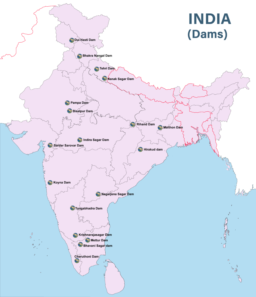
- On this map the Pampa Dam belongs in Pathanamthitta district of Keralam, on the Pamba.
List of Major Dams in India
Himalaya and the North-West
- These dams sit on snow-fed rivers that flow all year, in steep and dissected terrain.
- The Indus system dams (Bhakra, Pong, Thein, Salal, Dulhasti) follow the rivers across the Shiwalik and Lesser Himalayan belts, from Jammu and Kashmir to Punjab. Tehri stands on the Ganga headwaters.
- Many of them lie in zones of high seismic risk, a recurring concern in the debate on height.
| Dam or project | State or UT, and place | River | Significance |
|---|---|---|---|
| Bhakra Nangal | Himachal Pradesh (Bilaspur) and Punjab (Nangal), along their border | Satluj (Sutlej) | Bhakra is a 226 m gravity dam behind Gobind Sagar |
| Thein (Ranjit Sagar) | Punjab–Jammu and Kashmir border, near Pathankot | Ravi | Irrigation and 600 MW |
| Beas Project | Pandoh and Pong in Himachal Pradesh; joint venture of Punjab, Haryana and Rajasthan | Beas | Beas–Satluj link and Pong Dam |
| Sharda Sahayak | Uttar Pradesh | Sharda (Ghaghara system) | Long feeder canal from the Lower Sharda Barrage |
| Tehri | Uttarakhand (Tehri Garhwal) | Bhagirathi | India’s highest dam; complex of 2,400 MW |
| Dulhasti | Jammu and Kashmir (Kishtwar) | Chenab | 390 MW |
| Salal | Jammu and Kashmir (Reasi) | Chenab | 690 MW |
Ganga Plain, Central India and the East
- Most of these dams stand on plateau rivers entering or skirting the Ganga plain, or on the rift valley of the Narmada.
- The Son, Rihand, Betwa and Chambal drain north to the Ganga system. On the map, the Chambal chain runs from Gandhi Sagar past Rawatbhata to Kota.
- The Damodar group was built to tame floods in the coal and steel belt of Jharkhand and West Bengal.
| Dam or project | State or UT, and place | River | Significance |
|---|---|---|---|
| Rihand Dam, Rihand Scheme Reservoir | Uttar Pradesh (Pipri, Sonbhadra), with the reservoir reaching Madhya Pradesh | Rihand | Govind Ballabh Pant Sagar; 300 MW |
| Banasagar | Madhya Pradesh (near Deolond, Shahdol); shared with Uttar Pradesh and Bihar | Son | Cost and water shared 2:1:1 |
| Matatila | Uttar Pradesh (Lalitpur), with Madhya Pradesh | Betwa | Irrigation and power |
| Chambal project | Gandhi Sagar (Madhya Pradesh); Rana Pratap Sagar, Jawahar Sagar or Kota Dam (Rajasthan) | Chambal | Three-stage scheme |
| Bisalpur | Rajasthan (Tonk) | Banas | Storage on a Chambal tributary |
| Indira Sagar | Madhya Pradesh (near Punasa, Khandwa) | Narmada | 1,000 MW; regulates the dams below it |
| Tawa | Madhya Pradesh (Narmadapuram, formerly Hoshangabad) | Tawa, a Narmada tributary | 57.91 m high |
| Hirakud | Odisha (near Sambalpur) | Mahanadi | Main dam 4.8 km long |
| Maithon | Jharkhand (Dhanbad), on the West Bengal border | Barakar | Damodar Valley dam |
| Damodar Valley project, four dams | Tilaiya and Maithon on the Barakar; Konar on the Konar; Panchet on the Damodar. Jharkhand and West Bengal | Damodar | Flood control, power, irrigation |
| Mayurakshi | West Bengal command; Massanjore dam in Jharkhand | Mayurakshi | Irrigation for Birbhum and nearby districts |
Western India and the Deccan
- West-flowing rivers (Narmada, Tapi, Mahi) meet the sea in Gujarat, so their last great dams lie close to the coast.
- The Western Ghats give Maharashtra its power sites, with heavy rain and a sharp drop, while the Godavari and Bhima dams store water for the rain-shadow Deccan.
| Dam or project | State or UT, and place | River | Significance |
|---|---|---|---|
| Sardar Sarovar | Gujarat (Narmada district, at Ekta Nagar, formerly Kevadia) | Narmada | 138.68 m level; 1,450 MW |
| Kakrapara (Kakrapar) | Gujarat | Tapi | Weir of the Ukai system |
| Ukai | Gujarat | Tapi | Vallabh Sagar reservoir area; 300 MW |
| Mahi Project (Jamnalal Bajaj Sagar) | Rajasthan (Banswara), with Kadana lower down in Gujarat | Mahi | Power and irrigation |
| Koyna | Maharashtra (Satara) | Koyna | 1,960 MW; Shivaji Sagar |
| Jayakwadi | Maharashtra (Paithan, Chhatrapati Sambhajinagar, formerly Aurangabad) | Godavari | Irrigation and 12 MW |
| Bhima project | Maharashtra (Ujjani in Solapur, Pawana in Pune) | Bhima | Irrigation and 12 MW at Ujjani |
Peninsular South
- The Krishna and its tributaries (Ghatprabha, Malprabha, Tungabhadra) carry a chain of irrigation dams across northern Karnataka into Telangana and Andhra Pradesh.
- The Kaveri runs through Krishnarajasagar and Shivasamudram to Mettur. Rain-fed rivers here need storage to last through the dry season.
| Dam or project | State or UT, and place | River | Significance |
|---|---|---|---|
| Nagarjuna Sagar | Telangana (Nalgonda) and Andhra Pradesh (Palnadu), along their border | Krishna | Two main canals; about 816 MW |
| Poochampad (Sriram Sagar) | Telangana (Nizamabad) | Godavari | Irrigation for northern Telangana |
| Upper Krishna | Karnataka (Almatti, Vijayapura) | Krishna | Lal Bahadur Shastri Sagar at Almatti |
| Ghatprabha | Karnataka (Hidkal, Belagavi) | Ghatprabha, a Krishna tributary | Irrigation |
| Malprabha | Karnataka (Navilatirtha, Belagavi) | Malprabha | Irrigation |
| Tungabhadra | Karnataka (Hosapete, Vijayanagara) | Tungabhadra | Serves Karnataka, Andhra Pradesh and Telangana |
| Krishnarajasagar | Karnataka (Mandya) | Kaveri | Vrindavan Gardens beside it |
| Shivasamudram Scheme | Karnataka | At the Kaveri falls | Power since 1902 |
| Sharavati Project | Karnataka (Sagara, Shivamogga) | Sharavati | Near Jog Falls |
| Mettur | Tamil Nadu | Kaveri | Stanley Reservoir |
| Bhavani Sagar | Tamil Nadu (Erode) | Bhavani | Lower Bhavani canal |
| Kundah | Tamil Nadu (Nilgiris) | Kundah | Hill power chain |
| Cheruthoni | Keralam (Idukki) | Cheruthoni, in the Periyar basin | Part of the Idukki scheme |
Dams of Keralam and Others in the News
- Most of these are hill reservoirs on short Western Ghats rivers. They fall in the Periyar, Pamba, Chalakudi and Karamana basins.
| Dam | State and district | River |
|---|---|---|
| Edamalayar | Keralam (Ernakulam) | Idamalayar, a Periyar tributary |
| Idukki | Keralam (Idukki) | Periyar |
| Cheruthoni | Keralam (Idukki) | Periyar system |
| Peppara | Keralam (Thiruvananthapuram) | Karamana |
| Kakki | Keralam (Pathanamthitta) | Kakki, a Pamba tributary |
| Anathode | Keralam (Pathanamthitta) | Anathode, a Pamba tributary |
| Sholayar | Keralam (Thrissur) | Chalakudi |
| Kallarkutty | Keralam (Idukki) | Muthirapuzha |
| Kundala | Keralam (Idukki) | Muthirapuzha, a Periyar tributary |
| Pampa | Keralam (Pathanamthitta) | Pamba |
| Malankara | Keralam (Idukki) | Thodupuzha |
| Peechi | Keralam (Thrissur) | Manali, in the Karuvannur basin |
| Nanak Sagar | Uttarakhand (near Nanakmatta) | Deoha |
Three Dams in Detail
Mullaperiyar Dam
- A masonry gravity dam in Idukki district of Keralam, on the Periyar in the Western Ghats, next to the Periyar Wildlife Sanctuary.
- Built under colonial rule between 1887 and 1895, it opened on 10 October 1895. It is thus about 131 years old in 2026, far past its designed life of 50 years.
- Such a dam stays in place through its own weight and the width of its base, which stop it overturning under the force of the stored water.
- Why it is called hazardous: its age, and its site in an acknowledged seismic zone III.
- The call to decommission:
- Keralam’s hydrological reviews of 2006 to 2011 held that it could not safely pass the estimated probable maximum flood.
- IIT-Roorkee and IIT-Delhi studies were cited in support of taking it out of service. The Roorkee report of 2009 warned of damage from a magnitude 6.5 earthquake with water at 136 feet.
- The lease: a 999-year agreement of 29 October 1886 between Travancore and the British Secretary of State for India, renewed in 1970. Tamil Nadu inherited it and strongly opposes decommissioning.
- It lets Tamil Nadu operate the dam and take 640 million cubic metres a year for irrigation and power.
- The water passes through a tunnel bored across the Western Ghats, the range between the two States.
- Dated legal position:
- May 2014: the Supreme Court struck down Keralam’s 2006 law, allowed Tamil Nadu to store water up to 142 feet and set up a Supervisory Committee.
- October 2025: the Court issued notice on a plea for a new dam to replace it.
- 1 September 2026: a Comprehensive Safety Assessment Committee, flowing from a 2022 direction of the Court, finished the first phase of its inspection. The report goes to the National Dam Safety Authority.
Daudhan Dam and the Ken–Betwa Link
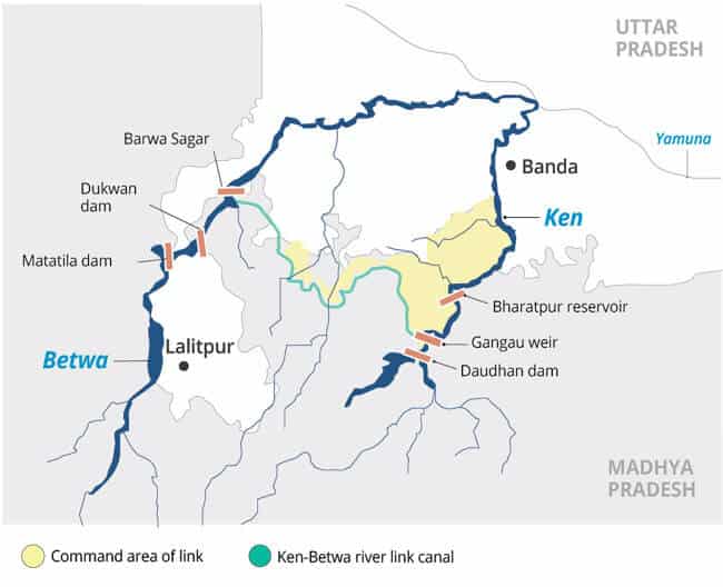
- Daudhan Dam stands on the Ken in Panna and Chhatarpur districts of Madhya Pradesh, about 2.5 km upstream of the Gangau Weir and about 40 km from Khajuraho.
- Height: 77 m in the earlier plan and 96.7 m in the official account of 21 August 2026.
- The Ken–Betwa Link was the first project of the national plan for interlinking rivers to enter implementation, and it is meant for drought-prone Bundelkhand.
- The foundation stone was laid on 25 December 2024. The approved cost is ₹44,605 crore, and completion is scheduled for 2030.
- A 216.465 km canal will carry water to Barua Sagar near Jhansi.
- Planned benefits: 10.62 lakh hectares irrigated, drinking water for about 62 lakh people, 103 MW of hydropower and 27 MW of solar power.
- The two phases:
- Phase I: the Daudhan complex with its low-level and high-level tunnels, the link canal and powerhouses.
- Phase II: the Lower Orr dam, Bina complex and Kotha barrage.
- In August 2026 the dam and these three Phase II works were under construction, while work on the canal had yet to begin.
- Costs:
- Daudhan would drown about 10% of the critical tiger habitat of Panna Tiger Reserve, which harms tiger conservation.
- The Daudhan and Makodia reservoirs together would displace about 20,000 people of Bundelkhand, raising rehabilitation issues. The official count of affected villages in Madhya Pradesh is 22.
Polavaram Irrigation Project
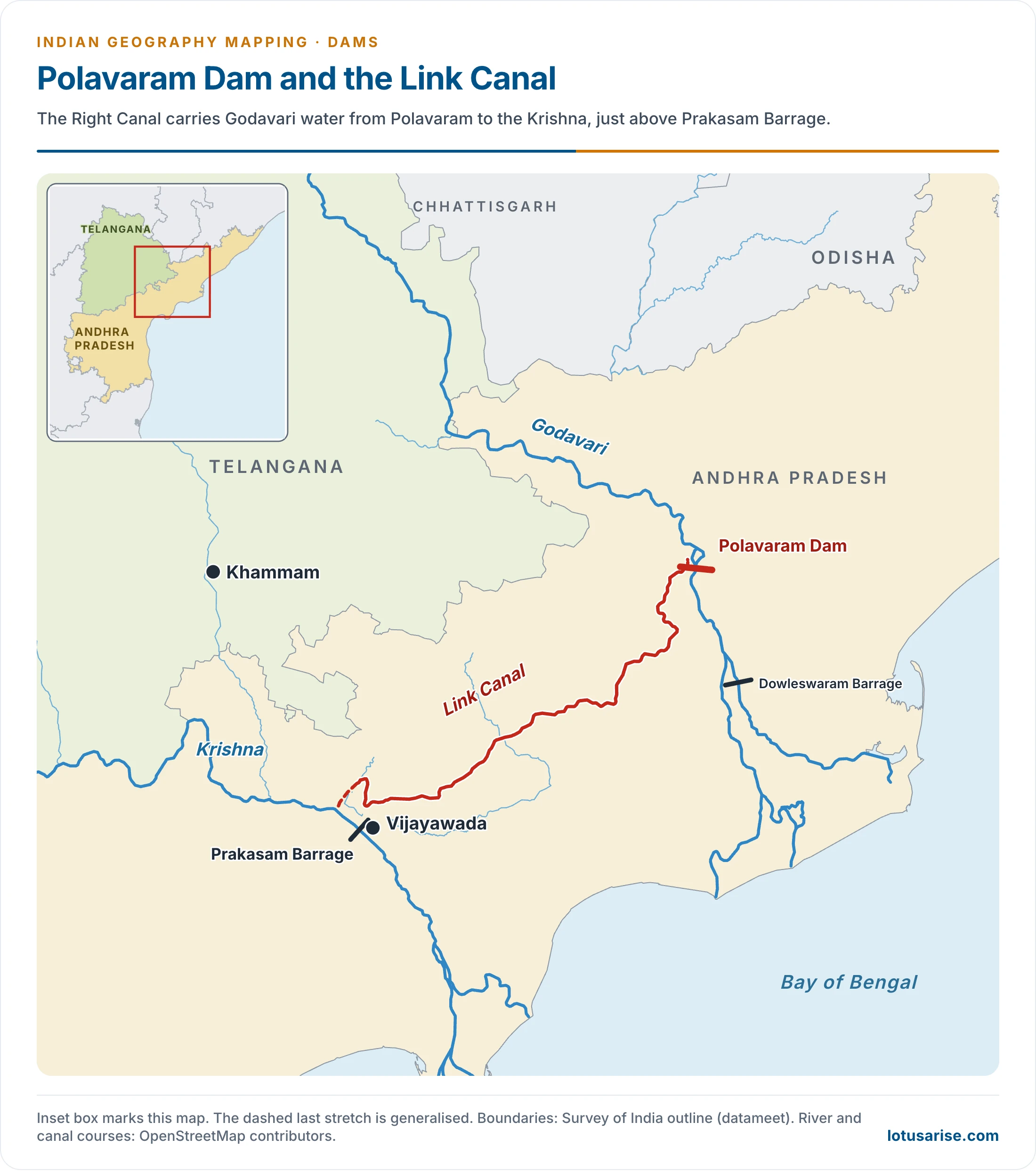
- Polavaram stands on the Godavari in Andhra Pradesh, near Polavaram village, close to where the river leaves the Eastern Ghats gorge.
- It is multipurpose: irrigation, hydroelectric power and drinking water on completion.
- Its Right Canal will make an inter-basin transfer to the Krishna basin.
- Indirect gains include fish breeding and rearing (pisciculture), tourism and urban growth.
- Its reservoir spreads into Chhattisgarh and Odisha, and backwater reaching Telangana is also in dispute.
- National project status came in 2014, under Section 90 of the Andhra Pradesh Reorganisation Act, 2014.
- People affected: chiefly the Koya and Konda Reddi tribes, whose forest-based livelihoods are lost to the submergence.
- Status in September 2026:
- 90.1% overall physical progress, with land acquisition at 95.6% and resettlement at 51.9%.
- The Union Cabinet approved a revised Phase I cost of ₹30,436.95 crore in August 2024.
- Major works are targeted for June 2027, after a run of earlier deadlines.
- Six other projects in Andhra Pradesh were listed beside it:
- Vamsadhara Phase 2, on the Vamsadhara (Banshadhara).
- Vamsadhara–Nagavali link, joining those two rivers.
- Owk tunnel 2.
- Velugonda Phase 1.
- Nellore barrage.
- Sangam barrage.
Previous Year Questions
2026Construction of large dams poses serious challenges. Describe the threats and solutions associated with it.2021Map item: Peechi Dam2015Map item: Polavaram2013Map item: Rihand Dam






This post is Very useful for everyone……
🍺
Thank u so much for this detailed coverage !!
ನಮಗೆ pdf ಬೇಕು
Please check out this page
https://store.lotusarise.com/
Sir i purchased ur geography india map module. Does it have latest places in news??
No, You will have to cover the latest places in news from any current affairs magazine.
All these content are very useful for all govt. exam like PCS, UPSC and SSC. Thank u sir🙏🙏
Thank you Sir 🙏🙏
I have a wish having hardcopy of these notes
Very relevant and to the point content that too for free.Thankyou so kuch 🙏🏻