

- A canal is an artificial channel that conveys water or carries boats and ships. It has a free surface under atmospheric pressure, and can be thought of as a man-made river.
- India’s canals range from Mughal and earlier works to modern systems that carry Himalayan water into the Thar. They gave 21% of net irrigated area in 2023-24 (17.42 million hectares).
Canal
- Canals let boats and ships pass between water bodies, and they also bring water for irrigation and other human uses.
- Two types are commonly separated:
- Waterways: the navigable parts of a body of water. They may lie within a bay or open sea, join two or more water bodies, or form networks inside a city.
- Aqueducts: channels used only to carry water for drinking, farming and hydroelectric power.
- In Indian irrigation law, the word also covers channels and reservoirs built, maintained or controlled by a State Government to supply or store water.
- By their head works, irrigation canals are either inundation canals, which run only when the river is high, or perennial canals, which draw from a barrage or dam.
List of Important Canals in India
| Canal | Area served | Chiefly for |
|---|---|---|
| Sethusamudram Shipping Canal Project | Tamil Nadu (Gulf of Mannar to Palk Bay) | Shipping; work halted |
| Indira Gandhi Canal | Punjab, Haryana, Rajasthan | Irrigation, drinking water |
| Buckingham Canal | Andhra Pradesh, Tamil Nadu | Navigation |
| National Waterway 3 (West Coast Canal) | Keralam (Kerala) | Navigation |
| Upper Ganges Canal | Uttarakhand, Uttar Pradesh | Irrigation |
| Lower Ganges Canal | Uttar Pradesh | Irrigation |
| Agra Canal | Delhi, Uttar Pradesh, Haryana, Rajasthan | Irrigation |
| Telugu Ganga project | Andhra Pradesh, Tamil Nadu | Drinking water, irrigation |
| Handri-Neeva | Andhra Pradesh | Irrigation, drinking water |
| K. C. Canal | Andhra Pradesh | Irrigation |
| Tajewala Canal | Haryana | Irrigation |
| Munak canal (part of Western Yamuna Canal) | Haryana, Delhi | Drinking water |
| Western Yamuna Canal | Haryana, Delhi | Irrigation |
| Kalingarayan Canal | Tamil Nadu | Irrigation |
| Buddha Nullah Canal | Punjab | Local channel |
| Satluj–Yamuna Link Canal | Punjab, Haryana | Water sharing |
| Sirhind Canal | Punjab | Irrigation |
| Anupgarh canal | Rajasthan | Irrigation |
| Narmada Canal | Gujarat, Rajasthan | Irrigation, drinking water |
| Conolly Canal | Keralam | Navigation |
| Lower Bhavani Project Canal | Tamil Nadu | Irrigation |
| Kaveri–Vaigai link canal | Tamil Nadu | Water transfer |
| Trivandrum–Shoranur canal | Keralam | Navigation |
| Tamirabarani–Nambiar link canal | Tamil Nadu | Flood water transfer |
| Kakatiya Canal | Telangana | Irrigation, drinking water |
| Sharda Canal | Uttar Pradesh | Irrigation |
| Zamania Canal | Uttar Pradesh | Irrigation |
| Deokali Canal | Uttar Pradesh | Irrigation |
| Karmanasa Canal | Bihar | Irrigation |
| Durgavati Canal | Bihar | Irrigation |
| Kutte Kol | Jammu and Kashmir | Local waterway |
| Nallah Mar or Mar Canal | Jammu and Kashmir | Filled in the 1970s |
| Tsoont Kol | Jammu and Kashmir | Local waterway |
| Cumbarjua Canal | Goa | Navigation |
| Soundane Cut | Maharashtra | Irrigation |
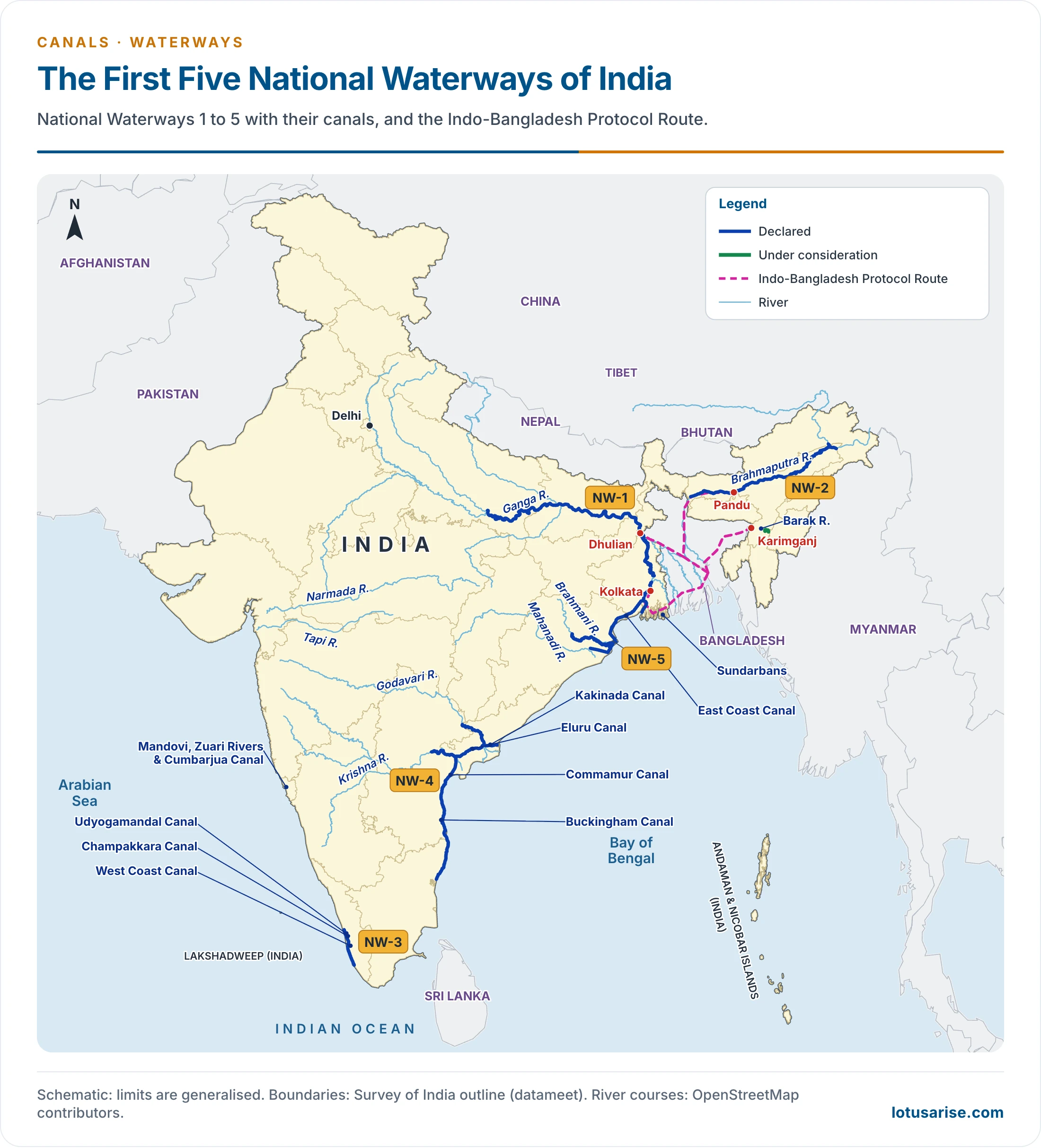
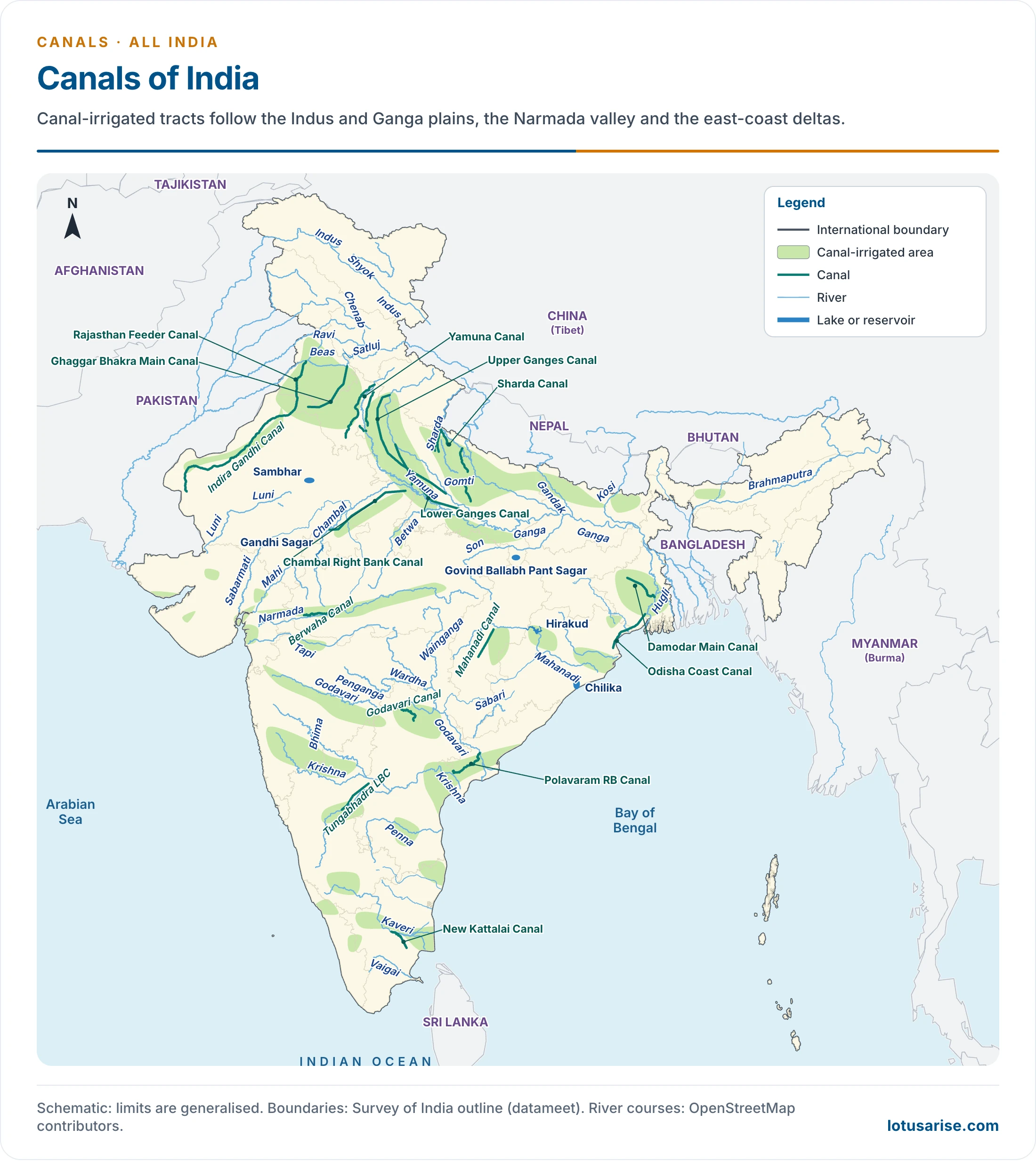
- This map shows only the first five national waterways. The National Waterways Act, 2016 extended the list to 111, and took National Waterway 3 on to Kozhikode.
Major Canals
Upper Ganges Canal
- The Upper Ganges Canal is the original Ganges Canal, begun in 1842 and opened in 1854 under the engineer Sir Proby Thomas Cautley.
- It starts at the Bhimgoda Barrage near Har ki Pauri at Haridwar, and crosses Meerut and Bulandshahr to Nanau in Aligarh district, where it divides into the Kanpur and Etawah branches.
- Length: the main canal is about 342 km, and a figure of 1,412 km is quoted for the system. Distributaries add about 6,200 km.
- It irrigates the Doab, on about 7 lakh hectares in the classical count.
- Its first stretch between Haridwar and Roorkee crosses broken ground, so the canal passes over some streams and under others.
Lower Ganges Canal
- This is the lower part of the Ganga canal system, from a barrage at Narora in Bulandshahr district, taken off in 1878.
- Two main branches: the Bhognipur Branch, starting near Jera village in Mainpuri district and opened in 1880, and the Kanpur and Etawah branch.
- With distributaries it runs about 6,000 km, and irrigates about 4.6 lakh hectares from Bulandshahr down to Fatehpur and Allahabad.
Indira Gandhi Canal
- The Indira Gandhi Canal, originally the Rajasthan Canal, is the longest canal in India. Work began on 31 March 1958, and it took its present name in 1984.
- It starts at the Harike Barrage, a few kilometres below the confluence of the Satluj and Beas in Punjab, and ends in the irrigated tracts of the Thar in north-west Rajasthan.
- Length: 649 km, made up of the 204 km feeder and the 445 km main canal. An older split gives 167 km outside Rajasthan and 492 km inside.
- Its command, stages, gains and ecological costs are worked through under the Command Area Development Programme.

Buckingham Canal
- The Buckingham Canal is a 796 km navigation canal that runs parallel to the Coromandel Coast, from Kakinada in the East Godavari district of Andhra Pradesh to Viluppuram district in Tamil Nadu.
- It links many coastal water bodies, including Pulicat Lake, the Krishna River and the port of Chennai.
- Parts of it now carry national waterway status: North Buckingham Canal (Pedaganjam to Chennai, 316 km) and South Buckingham Canal (Chennai to Marakkanam, 110 km).
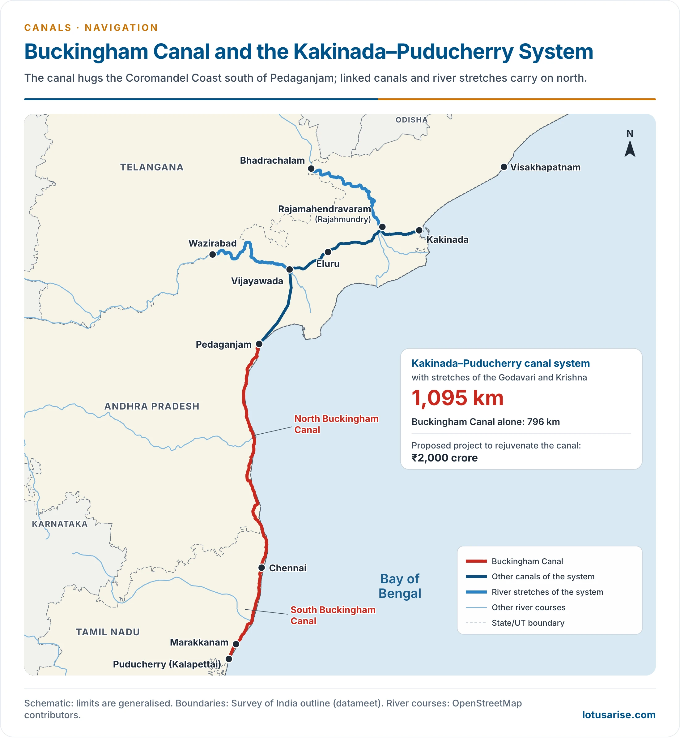
- The Kakinada–Puducherry canal system, with stretches of the Godavari and Krishna, runs 1,095 km. The National Waterways Act, 2016 extended that waterway to 2,890 km.
Satluj–Yamuna Link Canal
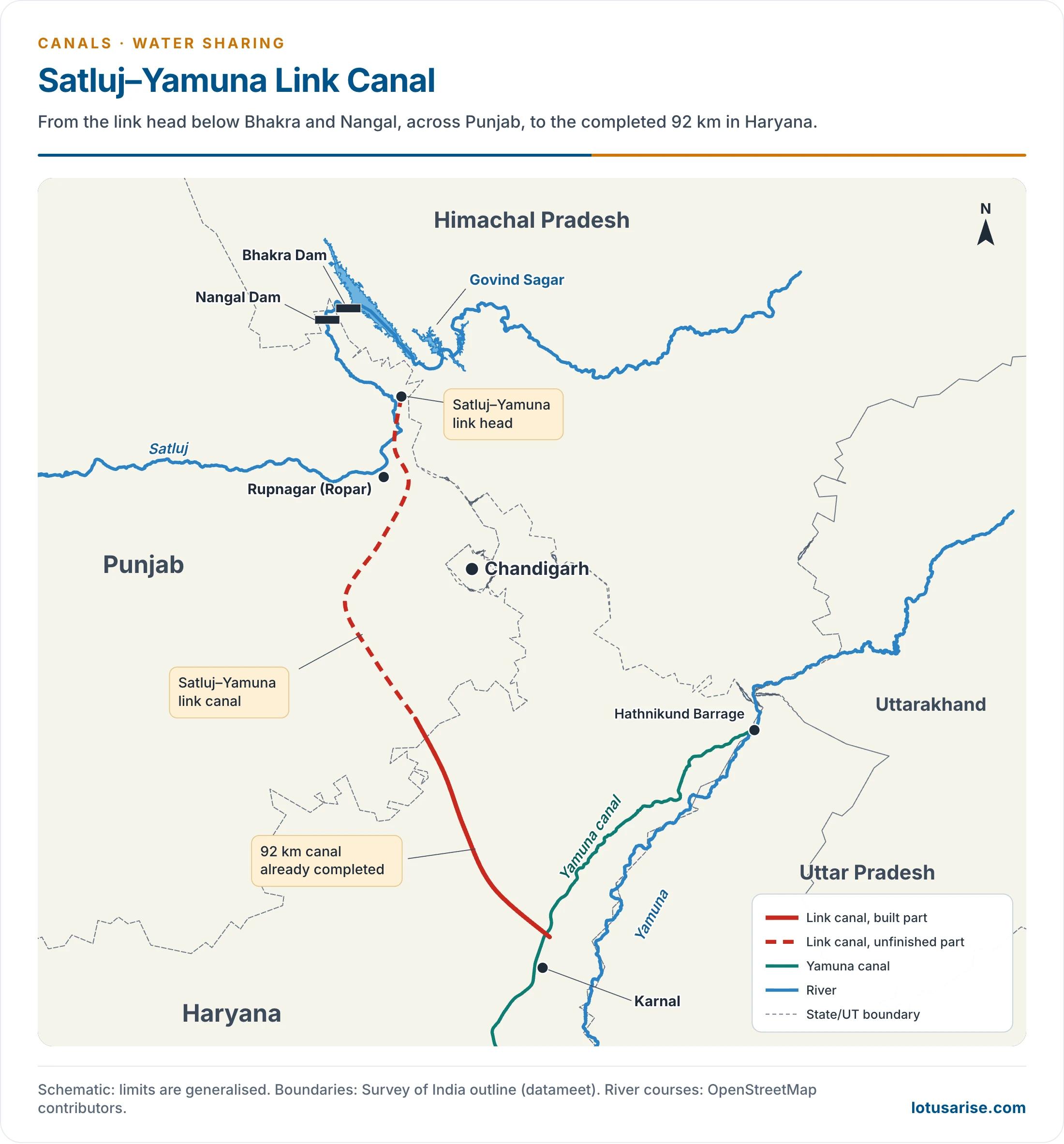
- The Satluj–Yamuna Link (SYL) is a major project to connect the Satluj and the Yamuna, so that Haryana can draw its share of Ravi–Beas water.
- Length: 214 km, of which 122 km lies in Punjab and 92 km in Haryana. It is a water-sharing canal.
- Status: Haryana has built its part, and the Punjab part remains unfinished. About 90% of the work is commonly reported as done, with 10% remaining, and the dispute continues.
- Punjab’s 2004 law ending the water agreements was struck down by the Supreme Court in 2016.
- The Court has since pressed the two States and the Centre to settle, and the Chief Ministers met again in January 2026.
- The river context is under the Indus system.
Western Yamuna Canal
- The Western Yamuna Canal goes back to Firoz Shah Tughlaq, who reigned from 1351 and carried it towards Hansi by about 1355.
- It had silted up by the 18th century. The British renovated it from 1817 under Captain G. R. Blane.
- Length: the main canal is 86 km, and 325 km with its branches. With all distributaries the network reaches about 3,200 km.
- Head works:
- It now draws from the Hathnikund Barrage in Yamunanagar district of Haryana, commissioned in 1999. The Dakpathar barrage in Dehradun district stands upstream on the same river.
- Hathnikund replaced the older Tajewala Barrage, also in Yamunanagar, which used to regulate the flow.
- The Pathrala barrage and Somb river dam on its course help harvest water.
- Branches: the Sirsa branch, among its largest, was built by 1895, after work began in 1889. The Delhi and Hansi branches are others, and one branch feeds the Agra Canal near Okhla.
- The Munak Canal, 102 km long, carries Yamuna water from Karnal district to Delhi for drinking.
- It irrigates a wide tract of Haryana and adjoining Punjab, including Ambala, Karnal, Rohtak, Jind and Hisar.
- Its neighbour on the left bank is the Eastern Yamuna Canal. The Yamuna system sets out how the two leave the river.
Sharda Canal
- The Sharda Canal is the longest canal system of Uttar Pradesh, a network of many branches.
- It leaves the Sharda at Banbasa on the Nepal border, now in Uttarakhand, and was completed about 1928. It runs through Pilibhit district.
- Length: 938 km including its branches. Counting distributaries, the system reaches about 13,624 km. It irrigates about 8 lakh hectares.
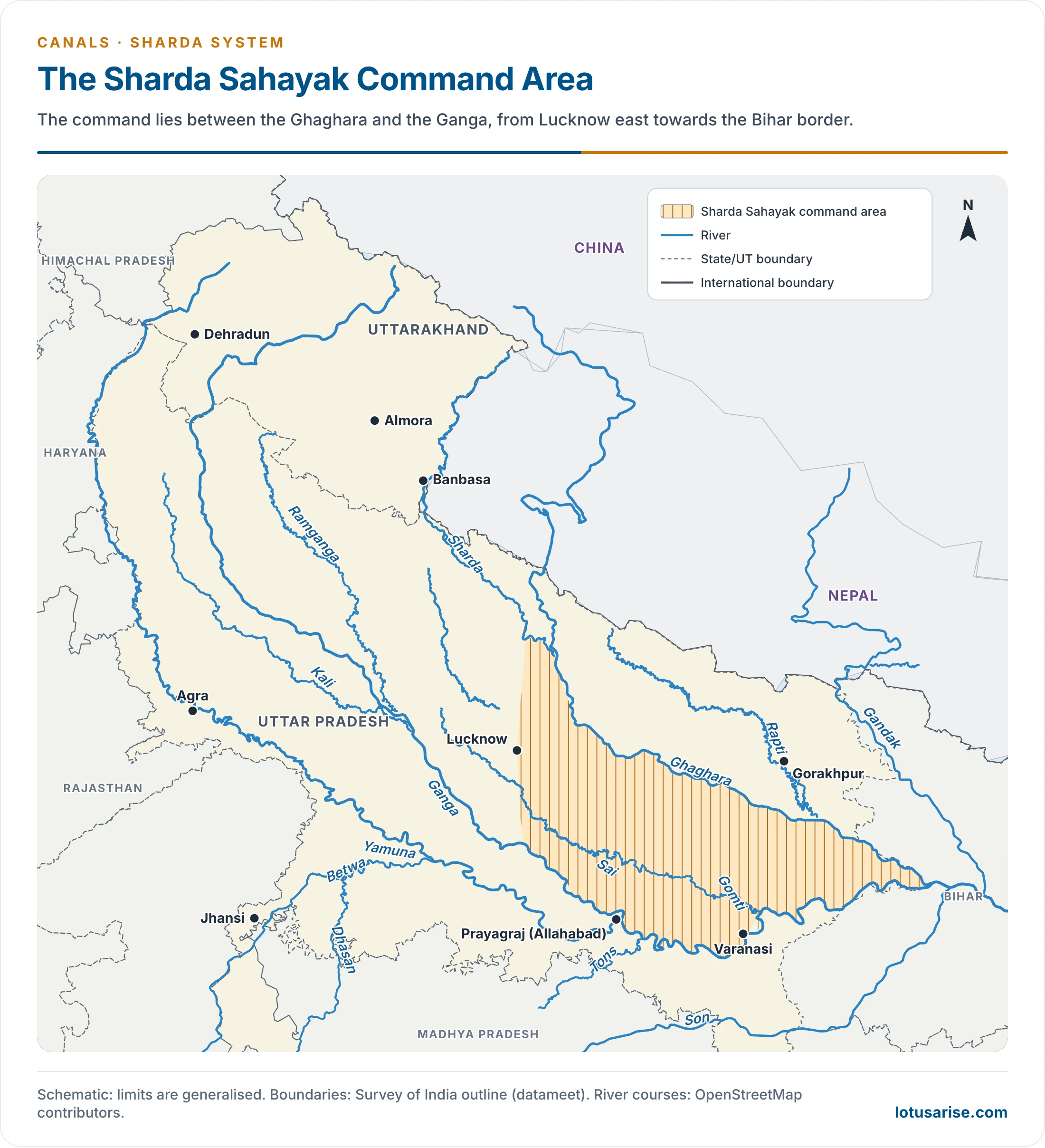
- This map shows the command of the later Sharda Sahayak project, not the Sharda Canal itself. A 258.8 km feeder leaves the Lower Sharda Barrage for eastern Uttar Pradesh.
Narmada Canal
- The Narmada Canal is a major irrigation canal of western India, from the Sardar Sarovar Dam at Navagam in Gujarat.
- Length: about 460 km in Gujarat and 74 km in Rajasthan, 534 km in all (458 km and 532 km on another count).
- Scale: it is 73 m wide at the bed in its head reach and 7.6 m deep. The irrigable command is about 52,60,000 acres (21.3 lakh hectares), mostly in Gujarat.
- It has transformed the arid lands of Kachchh and adjoining dry tracts, and of Jalore and Barmer in Rajasthan.
Kakatiya Canal
- The Kakatiya Canal is an important canal of Telangana, from the Sriram Sagar Reservoir, and it discharges into the Lower Manair Dam.
- It irrigates land and supplies drinking water across North Telangana, including Nizamabad, Warangal, Karimnagar and Khammam.
- Length: 284 km, with an average flow of 275 cubic metres a second. It carries Godavari water into the Krishna basin.
Agra Canal
- The Agra Canal starts at the Okhla barrage in Delhi. It was completed in 1874, and is about 230 km long.
- Its water comes off the right bank of the Yamuna.
- It irrigates nearly 1.5 lakh hectares in Agra, Mathura, Faridabad, Palwal and Bharatpur, and parts of Delhi.
Handri-Neeva Canal Project
- Handri-Neeva is one of the longest canals of the Rayalaseema region in southern Andhra Pradesh, and the work started in 2005.
- Length: the main canal is 565 km in the official count, and 569 km by phase.
- It lifts water from the Srisailam reservoir and runs through Anantapur, Chittoor, Kadapa and Kurnool districts.
- It is multi-purpose: irrigation, drinking water, and use of surplus flood water from Srisailam.
- Along its course it links Rayalaseema rivers such as the Penna, Chitravati, Mandavya and Papagni, and feeds many reservoirs.
- In 2025, the Phase 1 canal was widened to carry 3,850 cusecs.
Sirhind Canal
- The Sirhind Canal is an irrigation canal from the Satluj near Ropar in Rupnagar district of Punjab, opened in 1882.
- It serves most of the Malwa region of Punjab, with branches including the Patiala, Abohar, Bathinda and Kotla.
- It irrigates more than 5,200 square km. The Sirhind Feeder (142 km, 1960) adds Satluj–Beas water to the Abohar branch.
Soundane Cut
- Soundane Cut is the canal that begins at the Ujani dam.
- The dam stands at Ujani in Madha taluka, Solapur district of Maharashtra.
- It draws on the Bhima river.
Other Named Canals
- Sethusamudram: dredging at Adam’s Bridge was stopped by a Supreme Court interim order of 14 September 2007, and the matter is still pending.
- Telugu Ganga: takes Krishna water from Srisailam about 406 km through linked canals to Chennai’s Poondi reservoir.
- Kalingarayan Canal: a 90.5 km canal from the Kalingarayan anicut near Bhavani in Erode district, finished in 1283 by a Kongu chieftain.
- Conolly Canal: built from 1848 at Kozhikode, under Malabar Collector H. V. Conolly, as part of the West Coast Canal network.
- National Waterway 3: the 205 km Kollam–Kottapuram stretch was declared a national waterway in 1993.
- Cumbarjua Canal: the channel joining the Mandovi and Zuari in Goa.
- Nallah Mar: once Srinagar’s navigable link between Brari Nambal and Khushal Sar, it was filled in and made a road in the 1970s.
Canals State by State
- The table gathers the main canal systems outside those above. Areas are the classical irrigated figures, in lakh hectares where given.
| State | Canal or system | Source and points of note |
|---|---|---|
| Uttar Pradesh | Eastern Yamuna (2) | Yamuna; Saharanpur to Ghaziabad |
| Betwa (1.2) | Betwa, south-west of Jhansi; Jhansi, Jalaun, Hamirpur | |
| Ken, Chambal, Dhasan, Son | Southern districts | |
| Punjab | Upper Bari Doab (3) | Ravi at Madhopur; Gurdaspur, Amritsar; built 1849–59 |
| Bhakra (15, with neighbours) | Bhakra dam on the Satluj; also Haryana and Rajasthan; 1954 | |
| Bist Doab (4) | Bhakra–Nangal; Jalandhar, Hoshiarpur | |
| Haryana | Jui (0.32) | 169 km lift scheme for Bhiwani |
| Gurgaon (1.2) | Yamuna at Okhla; Gurgaon, Faridabad | |
| Rajasthan | Gang or Bikaner (3.4) | Satluj at Hussainiwala; 1928; 1,280 km |
| Chambal | Gandhi Sagar and later dams; with Madhya Pradesh | |
| Jawai, Banas, Gudha, Parbati, Bharatpur, Urmila | Smaller schemes | |
| Andhra Pradesh and Telangana | Godavari delta (4.5) | Dowlaiswaram and Ralli weirs; 1846 |
| Krishna delta and Sunkesula | Vijayawada anicut; Krishna and Tungabhadra | |
| Kurnool–Cuddapah (1.2) | Tungabhadra at Sunkesula | |
| Nagarjunasagar Right (6.7) and Left (3.56) | 204 km and 171 km; Krishna | |
| Bihar | Eastern and Western Sone | Sone; Patna, Gaya, Shahabad |
| Eastern and Western Kosi (4.5, 3.5 potential) | Near the Nepal border | |
| Tirhut (7) and Saran (7.6) | Gandak at Balmiki Nagar | |
| Triveni (1) | Champaran | |
| West Bengal | Mayurakshi | Birbhum, Murshidabad, Bardhaman |
| Kangsabati (1.2) | Bankura, Medinipur; 1965 | |
| Damodar Valley (5) | Damodar | |
| Madhya Pradesh | Chambal (2.83) | Gwalior, Bhind, Morena |
| Tawa (3), Barna (0.64), Wainganga | Hoshangabad, Raisen, Balaghat and Seoni | |
| Chhattisgarh | Mahanadi (3) | Rudri; 215 km main, 1,175 km distributaries |
| Tandula (1.1) | Raipur, Durg | |
| Odisha | Hirakud (2.4) | Mahanadi; Bolangir, Sambalpur |
| Mahanadi delta (4) | 3,650 km; Cuttack, Puri | |
| Taldanda (0.62) | Mahanadi catchment | |
| Karnataka | Ghataprabha (3.2), Tungabhadra (2.7) | Belgaum, Bijapur; Bellary, Raichur |
| Malaprabha (1), Bhadra (1), Visvesvaraya (0.5) | Krishnaraja Sagar feeds the last | |
| Tamil Nadu | Cauvery delta (4) | 6,400 km; Thanjavur, Tiruchirappalli |
| Mettur (1.2), Lower Bhavani (0.79) | Salem, Coimbatore | |
| Parambikulam–Aliyar, Manimuthar | Other projects | |
| Maharashtra | Mutha (0.45), Nira (0.66) | Pune, Satara, Solapur |
| Darna, Gangapur, Pravara | Nashik, Ahmednagar | |
| Tapi (3, with Gujarat), Mula, Girna, Jayakwadi, Warna | Later schemes | |
| Gujarat | Mahi (2), Ukai (1) | Kheda, Panchmahals; Tapi |
| Rudramala, Ozat, Dantiwada, Panam, Kakrapar | Other projects |
- Why canals concentrate in the north: low relief, deep soil and perennial rivers favour them. The hard, uneven plateau keeps them mainly to deltas and coasts in the south.
Previous Year Questions
2017Explain the inter-State issues involved in implementation of the Satluj-Yamuna Link Canal Project.2013Map item: Indira Gandhi Canal





Net area irrigation by source could be added canal account for 25%apx irrigated area after tubewell 62% in india