

“Geomorphological changes are largely responsible for environmental hazards in the Himalayan region.” Comment with relevant examples. (2018)
- The statement is largely valid: in the Himalaya, rain, earthquakes and warming usually act as triggers, but it is the changing landform system — rising relief, steepening and weakening slopes, retreating glaciers, aggrading channels and human-cut terrain — that decides where a trigger becomes a disaster and how big it becomes.
- “Geomorphological change” here covers both natural change (uplift, incision, deglaciation, permafrost thaw) and human-induced change to slopes and drainage, which is now the fastest-growing part.
Why Himalayan Geomorphology Is Hazard-Prone
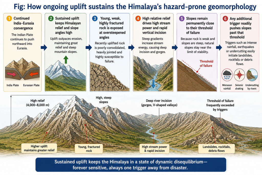
- Active tectonics: India still converges with Eurasia, and roughly 2 cm a year of shortening is taken up across the Himalaya, keeping relief high and slopes close to their threshold angle.
- Weak, fractured rock: young folded sedimentary and metamorphic rocks are crushed along the Main Central and Main Boundary Thrusts, so landslides cluster along these zones.
- High relative relief and rapid incision: rivers cut gorges faster than slopes can stabilise, leaving over-steepened, undercut valley sides and huge sediment loads.
- Paraglacial readjustment: glacier retreat leaves loose moraines, debuttressed rock walls and new lakes, while thawing permafrost weakens frozen debris.
- Seismic shaking converts this latent instability into failure: the 2015 Gorkha (Mw 7.8) earthquake set off thousands of landslides across Nepal, and the 2011 Sikkim earthquake did the same in the Teesta basin.
Examples Supporting the Statement
Mass movements and debris flows
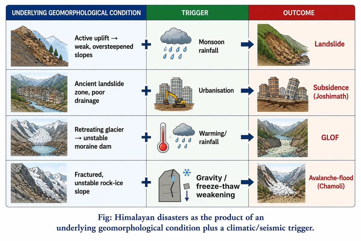
- Chamoli, 7 February 2021: about 27 million m³ of rock and glacier ice broke from Ronti Peak and became a debris flood in the Rishiganga and Dhauliganga, leaving over 200 dead or missing and wrecking two hydropower projects (Dan H. Shugar and colleagues, 2021); there was no rain at all — a purely geomorphic failure of a weathered, glacier-weakened rock–ice slope.
- Dharali, 5 August 2025: a debris flow in the Kheer Gad catchment, fed by morainic and glacio-fluvial debris, buried the settlement at the stream’s mouth, though only about 20 mm of rain fell at Dharali that day (debris source: Ratan Das, 2026; rainfall: Rohit Thapliyal and colleagues, 2026 preprint).
Glacial lake outbursts
- South Lhonak, Sikkim, 3–4 October 2023: 14.7 million m³ of frozen lateral moraine collapsed into the lake, raising a ~20 m wave that breached the dam, drained ~50 million m³ of water and destroyed the Teesta-III dam at Chungthang (Ashim Sattar and colleagues, 2025).
- Kedarnath, June 2013: extreme rain triggered the breach of Chorabari Lake and debris flows onto a town built on glacial outwash below the Chorabari Glacier — rain was the trigger, landform setting the multiplier.
Channel change downstream
- Kosi, August 2008: Himalayan sediment has raised the Kosi’s bed within its embankments; the river breached its eastern embankment at Kusaha (Nepal) and swung into an older course, affecting about three million people in Bihar — a flood shaped by aggradation and avulsion, not by unusual rainfall.
Land subsidence
- Joshimath sits on old landslide debris, as the Mishra Committee warned in 1976; satellite studies found subsidence of about 6.5 cm a year (2020–22) and a rapid 5.4 cm in 12 days in late December 2022–early January 2023, and hundreds of houses cracked.
The Contrary View: Triggers and Human Action
- Climatic extremes are rising: cloudbursts and multi-day extreme rainfall, such as the record July 2023 rains in Himachal Pradesh, cause most monsoon disasters; on stable terrain the same rain would cause far less damage, but without it many slopes would not fail.
- Warming drives the geomorphic change itself: glacier retreat and permafrost thaw are climatic in origin, so separating “geomorphic” from “climatic” causes is partly artificial.
- Human modification is the main accelerator: road widening by vertical cutting, hydropower tunnels and muck dumping, unplanned construction on old landslide debris, and blocked drainage (all cited at Joshimath, where the role of the Tapovan–Vishnugad tunnel remains disputed).
- Earthquakes are tectonic, not geomorphic, events — though their damage is set by slope, relief and lithology.
Verdict
- Location and magnitude of Himalayan hazards are geomorphically determined; timing is set by rain, seismicity or warming; escalation into disaster increasingly follows human reshaping of slopes and floodplains.
- Hence hazard reduction must rest on geomorphic hazard zonation — mapping old landslide bodies, permafrost-affected moraines, debris fans and over-steepened road cuts — and not on rainfall forecasting alone.
- Judgement: the statement holds if “geomorphological change” includes human-made change to the land surface; Chamoli and Dharali show that geomorphic instability can produce disaster almost without a climatic trigger, but Kedarnath and Himachal 2023 show that extreme rain and careless construction decide how often the latent hazard is realised — so geomorphology is the necessary, but not always sufficient, cause.