

- System analysis studies a complex geographical reality as an interconnected whole. Population, resources, transport, settlements, economy, environment and culture are treated as linked parts of a larger spatial order, not as isolated facts.
- It asks three questions:
- What are the elements of a geographical phenomenon?
- How are they linked through flows, feedbacks and controls?
- How does the whole behave when one part changes?
- It is less a theory than a way of thinking, and it gives a methodological base to central place theory, the gravity model, input–output, migration, urban land-use, ecosystem, watershed and regional planning models.
- It suits geography because geographical phenomena are spatial, dynamic and interdependent.
Concept and Origin

Meaning of System and System Analysis
- A system is a set of interrelated and interdependent elements forming a unified whole: something that functions as a whole because its parts depend on one another, such as a person, a state, a culture or a business.
- It has a boundary, receives inputs, transforms them through processes, produces outputs and operates within a wider environment.
- A city, a region, a farm economy, a river basin and a migration stream all work this way.
- System analysis identifies the components, examines their relationships, measures the flows and predicts behaviour under changing conditions.
- It is a mathematical approach too: techniques from control engineering test how systems respond to external stimuli.
- In human geography it covers cities, markets, transport networks, migration streams, regional economies, population–resource relations, political territories and human–environment interaction.
- Its special value lies in handling complex multivariate situations.
- A system is not the model made of it. Real landscapes are open, yet analysis must treat them as conceptually closed, considering only a finite set of elements and disregarding the rest.
- David Harvey (1969) gave the example of a firm: if its economic circumstances are held fixed, widening the boundary to include social and political change may alter the result.
Origin and Intellectual Background
- The approach comes from general system theory, developed by the Austrian biologist Ludwig von Bertalanffy (1901–1972).
- From the 1920s he argued that an organism cannot be understood organ by organ. It must be studied as a system of associated parts.
- From 1932 he described the organism as an open system, holding a steady state through constant inflow and outflow.
- He then saw the same logic in non-biological systems and proposed a general theory for all sciences: “An Outline of General System Theory” (1950) and General System Theory (1968).
- General system theory seeks common patterns of organisation, interaction, hierarchy, equilibrium and feedback.
- It is a theory of general models, a higher-order generalisation of the systems each science recognises.
- For Mihajlo Mesarović it goes beyond analogy between systems: it sets up a general theory from which their characteristics can be deduced.
- It relates systems within a unified hierarchy, shows when one approximates another, and identifies useful types even before a real match is found.
- Cybernetics, named by Norbert Wiener (1948) from the Greek for steersman, is the study of regulating and self-regulating mechanisms in nature and technology.
- Body temperature is the classic case. Regulation is precise in nature and defective in human societies.
- It stresses interaction over a sharp split between cause and effect: an impulse returns to its origin after passing through other parts.
- The approach entered geography during the quantitative revolution, when the discipline sought to become more analytical and predictive.
| Scholar | Contribution |
|---|---|
| Ludwig von Bertalanffy | General system theory; open systems and interdependence |
| Norbert Wiener (1948) | Cybernetics: feedback and control |
| Richard J. Chorley (1962) | Open systems in geomorphology, replacing the cycle idea |
| Luna B. Leopold and Walter B. Langbein (1962) | Entropy and steady state in fluvial systems |
| Brian J. L. Berry (1964) | “Cities as systems within systems of cities”, using organisation and information |
| Michael J. Woldenberg and Berry (1967) | Rivers and central places as analogous systems |
| Chorley and Peter Haggett (1967) | Integrated models in geography |
| David Harvey (1969) | Analytical explanation in geography |
| Chorley and Barbara A. Kennedy (1971) | Physical Geography: A Systems Approach and its four system types |
| Richard J. Huggett (1980) | Systems Analysis in Geography: ecological, hydrological, regional and spatial-interaction uses |
- Chorley and Berry held system analysis to be a basic tool because geography deals with complex relations between living and non-living components. Chorley saw four advantages:
- systems should be studied rather than isolated phenomena;
- the principles governing systems should be identified;
- analogies across fields enrich explanation;
- general principles are needed to cover different systems.
- The approach also marks geography’s movement through three stages of science:
| Stage | Nature | Expression in geography |
|---|---|---|
| Descriptive | Description and mapping | Ancient and medieval geography, travel accounts, regional description |
| Analytical | Explanation and laws behind patterns | Alexander von Humboldt, Carl Ritter, distribution analysis |
| Predictive | Models and laws used to predict | Post-war quantitative geography, locational theories, planning models |
- The real rise of system analysis in human geography is a post-war development. Locational theories, spatial-interaction models, regional planning and controlled-system approaches moved the subject toward prediction and applied problem-solving.
Structure of a Geographical System
The Parts
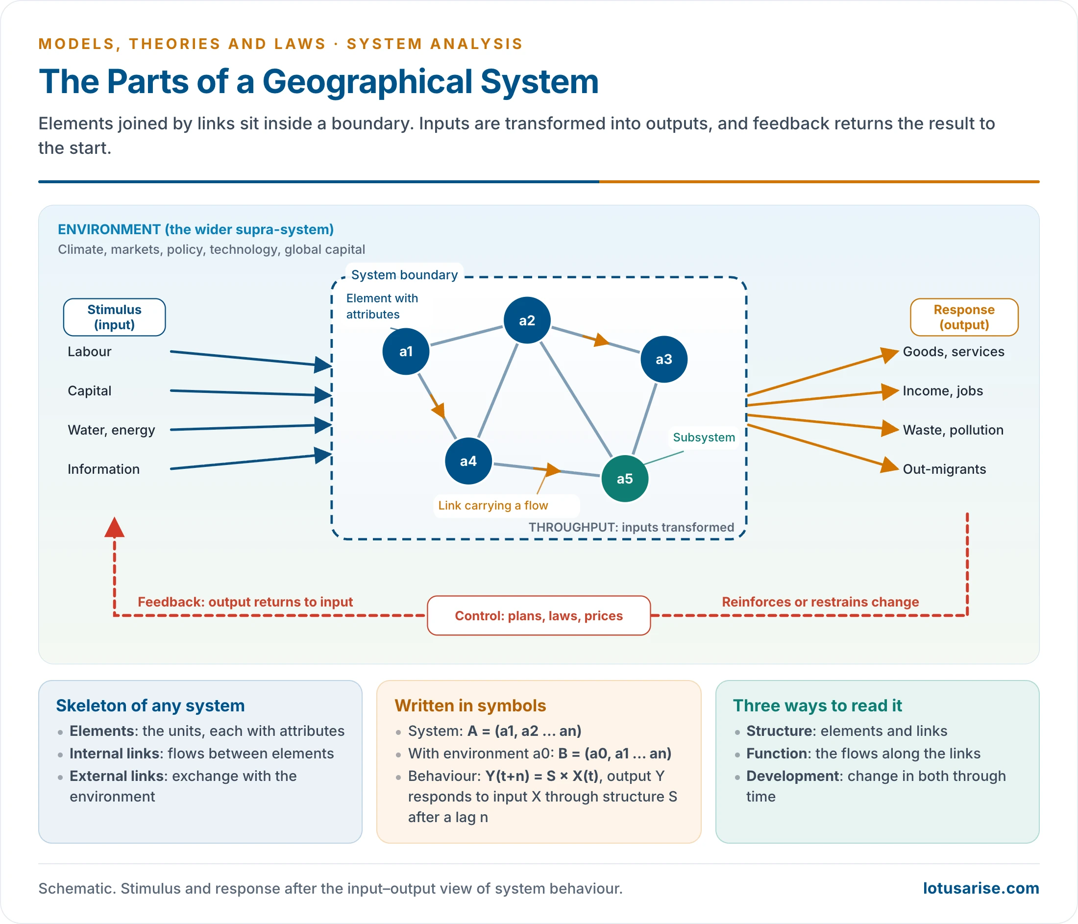
- A geographical system is not a random collection of facts. It is an organised arrangement of elements, relationships, flows and boundaries inside a wider environment.
- Its structure tells us what it is made of, how its parts connect and how it deals with the outside world. There are three components:
- Elements: farms, villages, cities, industries, households, rivers, roads or institutions.
- Internal links: movements of people, goods, capital, energy, information or decisions among them.
- External links: connections with the surrounding environment.
- A village, city, river basin, industrial region or transport network can be treated as a system only when these are clearly identified, because geographical phenomena are both spatially distributed and functionally linked.
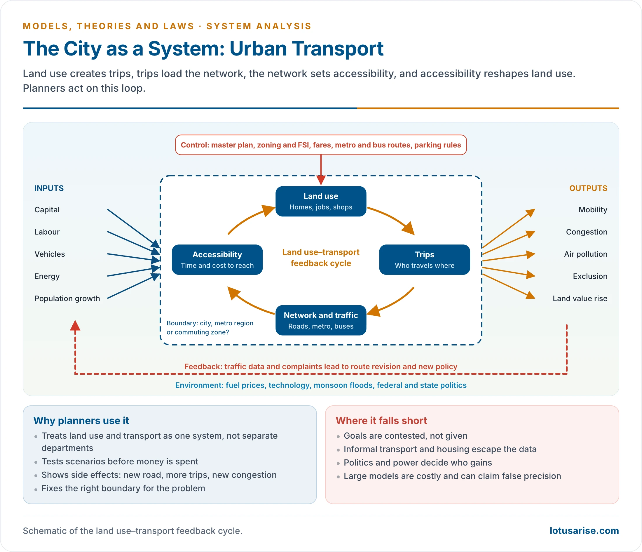
- A city’s urban transport system serves as a worked example of every part. It shows that a geographical system is both spatial and functional: it occupies space, and it works through movement, interaction and feedback.
| Part | What it is | Urban transport example |
|---|---|---|
| Elements | Basic units: physical, social, economic, political or cultural | Roads, buses, metro, stations, vehicles, commuters, signals |
| Attributes | Relevant characteristics of an element | Road width, capacity, travel time, frequency, cost, accessibility |
| Links | Visible or invisible connections, material or non-material | Road routes, metro lines, footpaths, feeder services |
| Flows | Movements along the links | Commuters, vehicles, fuel, information, traffic data |
| Boundary | What separates system from environment | Municipal city, metropolitan region or commuting zone |
| Environment | Wider setting that acts on and is acted on by the system | Land use, population growth, fuel prices, technology, policy, climate |
| Input | Resources, energy, information or stimuli entering | Capital, labour, vehicles, energy, infrastructure |
| Throughput | Process that transforms inputs | Movement, scheduling, routing, traffic regulation |
| Output | Products, services, results and impacts | Accessibility, congestion, pollution, travel efficiency |
| Feedback | Return flow of information from output to input or control | Traffic monitoring, complaints, route revision, policy change |
| Control | Regulation and decision-making | Master plans, zoning, environmental law, fiscal policy |
Reading Each Part
- Elements depend on scale and purpose.
- In a river basin they may be tributaries, slopes, soil, vegetation, settlements and fields. In an urban system they may be residential areas, markets, industries, terminals, offices and service zones.
- Cities are elements in a national urban system. In one city, wards, roads, households and land-use zones become the elements.
- A country is an element in the world economy, a firm in a national economy, a department in an organisation, a worker in a department. A car is an element in traffic and itself a mechanical system.
- Elements are easiest to identify when discrete, such as farms, and hardest when continuous, such as precipitation.
- Hubert M. Blalock and Ann B. Blalock (1959) showed that systems may interact as units, or through their sub-systems at lower levels.
- The element is its attributes. Mathematically an element is a variable, so the geographer works with a city’s population size, density, occupations, services and connectivity, or a farm’s size, soil, irrigation, crops and productivity.
- Links and flows give the system life. Without links, elements remain isolated facts.
- Links: roads between villages and towns, trade between regions, migration streams, digital networks, ecological ties among forest, rainfall, soil and runoff.
- Flows reveal function. In a metropolis, labour moves from suburbs to the CBD, capital into real estate and infrastructure, waste to disposal sites, and information through governance and digital platforms.
- The boundary decides what counts. It may be natural (a watershed), administrative (a district), functional (a commuting zone, a central place’s market area), or conceptual and perceptual.
- Delhi may be studied as a municipal system, the NCR urban system, part of the Yamuna basin, an air-pollution system or a national capital region, depending on the problem.
- Environment is the supra-system.
- Farming depends on climate, prices, policy, technology, rural society and global trade.
- Industry depends on raw material sources, labour, transport, energy, political stability and regulation.
- Delhi sits within the NCR, the Indian economy, the monsoon, an air-shed, federal governance and global capital.
- Boundary drawing is often the hardest step in practice, since it fixes what is treated as external.
- Inputs, throughput and outputs link cause, process and consequence:
- Agricultural system: land, water, seed, fertiliser, labour, credit and technology pass through ploughing, sowing, irrigation, weeding, harvesting and marketing to give crops, income, jobs, waste, soil exhaustion and groundwater depletion.
- Industrial region: iron ore, coal, electricity, labour, capital and transport yield goods, income, jobs, pollution, urbanisation and regional inequality.
- City: land, labour, capital and infrastructure become housing, services, employment and cultural landscapes.
- Feedback makes a system dynamic rather than static. If groundwater depletion cuts output, farmers shift crops, government regulates tube-wells or planners promote micro-irrigation: feedback leading to control.
- Controls in urban and regional systems include master plans, land-use zoning, environmental laws and fiscal policy.
- Systems nest within systems. Each element can be opened up as a sub-system, and each system is a part of a larger one, so the scale chosen must suit the question asked.
- In symbols, the system is A = (a1, a2, a3 … an). Adding the environment as a0 gives B = (a0, a1, a2 … an), which forces a decision on what is internal and what external.
- Behaviour is written Y(t+n) = S × X(t): a stimulus X passes through the structure S and gives a response Y after a lag n.
Structure, Function and Development
| Dimension | Meaning | Transport system | World iron ore trade |
|---|---|---|---|
| Structure | Arrangement of elements and links | Roads, railways, nodes, terminals | Producing and consuming centres; trade routes |
| Function | Flows along the links | Passenger and freight movement | Tonnage carried on each route |
| Development | Change in both through time | Road-based movement to metro, expressway, multimodal corridors | Maps of the pattern at successive dates |
- Input–output behaviour: a change in the environment affects at least one element, the effect passes through connected elements, and the system responds with a new output.
Types and Relationships
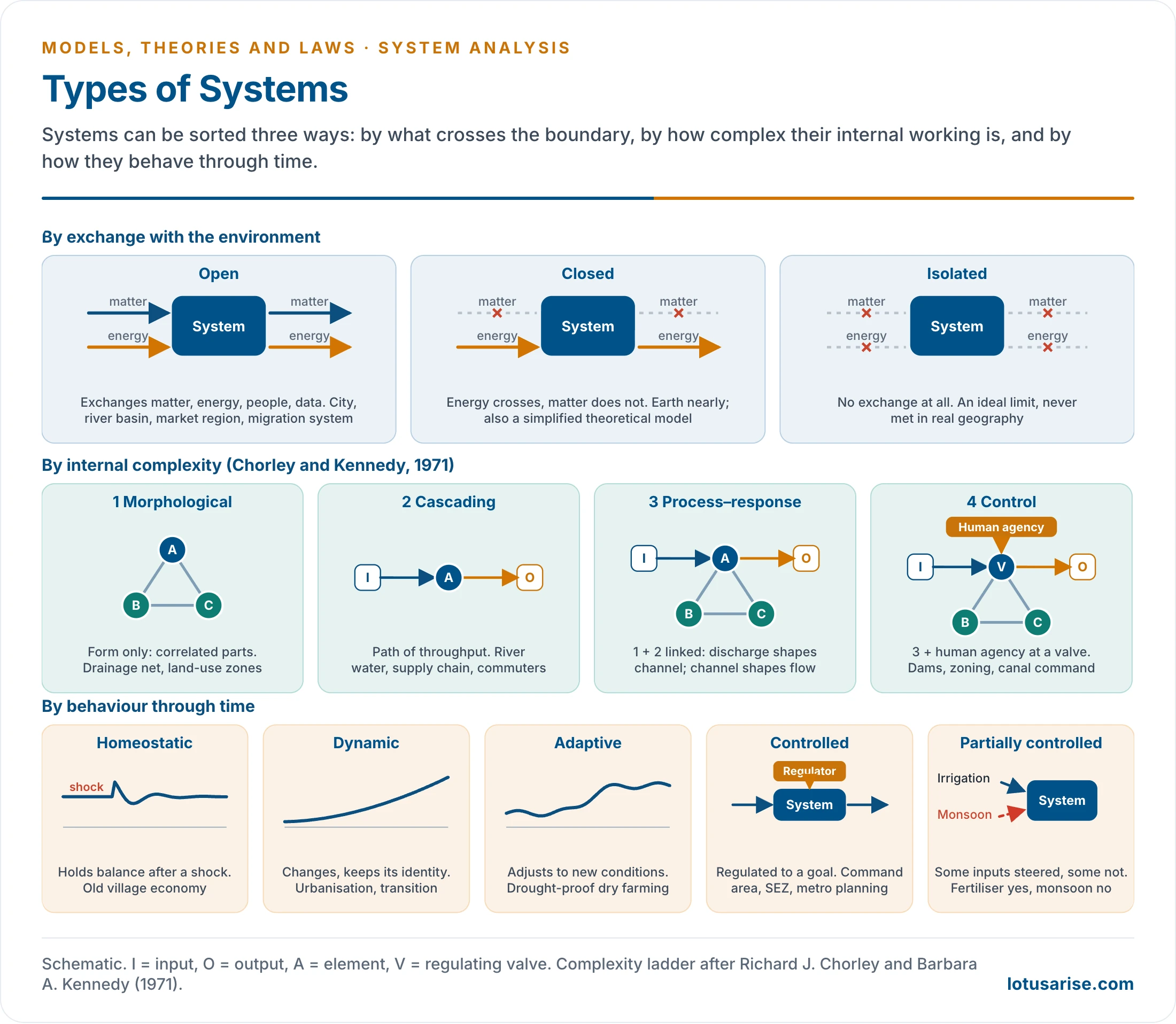
Types of Systems
| Basis | Type | Meaning | Example |
|---|---|---|---|
| Exchange | Open | Exchanges energy, matter, people, capital or information; most geographical systems | City, river basin, market region, migration system, ecosystem, industrial or agricultural region |
| Exchange | Closed | Energy crosses, matter does not; useful for model-building | Earth nearly; a laboratory experiment; a model with fixed assumptions |
| Exchange | Isolated | No exchange of matter or energy; an ideal limit | None in real geography |
| Complexity | Morphological | Structural relations among parts: form, arrangement, cross-correlation | Drainage network, land-use zones, settlement morphology |
| Complexity | Cascading | Path of throughput of energy, mass or information | Water through a basin, goods through a supply chain, commuters through a network |
| Complexity | Process–response | Links process and form: one morphological plus one cascading system | Discharge and sediment against channel shape and floodplain |
| Complexity | Control | Process–response system with human agency at key valves | Dam, zoning, canal regulation |
| Behaviour | Homeostatic | Keeps internal balance despite disturbance | Traditional village economy of land, labour, caste occupation and local exchange before market penetration |
| Behaviour | Dynamic | Changes through time but keeps a recognisable structure | Urbanisation, demographic transition, migration streams, industrial regions |
| Behaviour | Adaptive | Adjusts to changing conditions | Dryland farmers adopting drought-resistant crops, micro-irrigation, crop insurance |
| Behaviour | Controlled | Regulated by internal or external decisions | Command area development, Special Economic Zones, smart city projects, metropolitan transport planning |
| Behaviour | Partially controlled | Some inputs steered, others not | Fertiliser, irrigation and seed but not the monsoon; infrastructure but not migration or market response |
- Most geographical systems are open. A city imports food, water, labour, capital and information and exports goods, services, waste and ideas, which makes it a classic open system.
- Earth is open to energy, since solar radiation arrives and is re-radiated, and nearly closed to matter. Its physical stock is finite, which is the case for recycling and efficient use.
- Closed and isolated forms are rare in geography, but they serve as ideal concepts for model-building.
- Partially controlled systems matter most for planning. The objective is known and some inputs can be set, while others are impossible or too costly to manipulate.
- To raise farm output, a planner can set fertiliser, canal water and seed, but not the monsoon, farmer decisions, prices or migration.
- Geography is therefore not a fully controlled science like laboratory physics, and greater knowledge of the environment shows how much planning and control are needed.
- Static and adaptive systems are easily built in geography. A truly dynamic one is hard, since it must join time and space in one model, the problem tackled by time geography at Lund.
- Physical geography’s versions of these types belong to geomorphic systems and ecosystems.
Relationships in a System
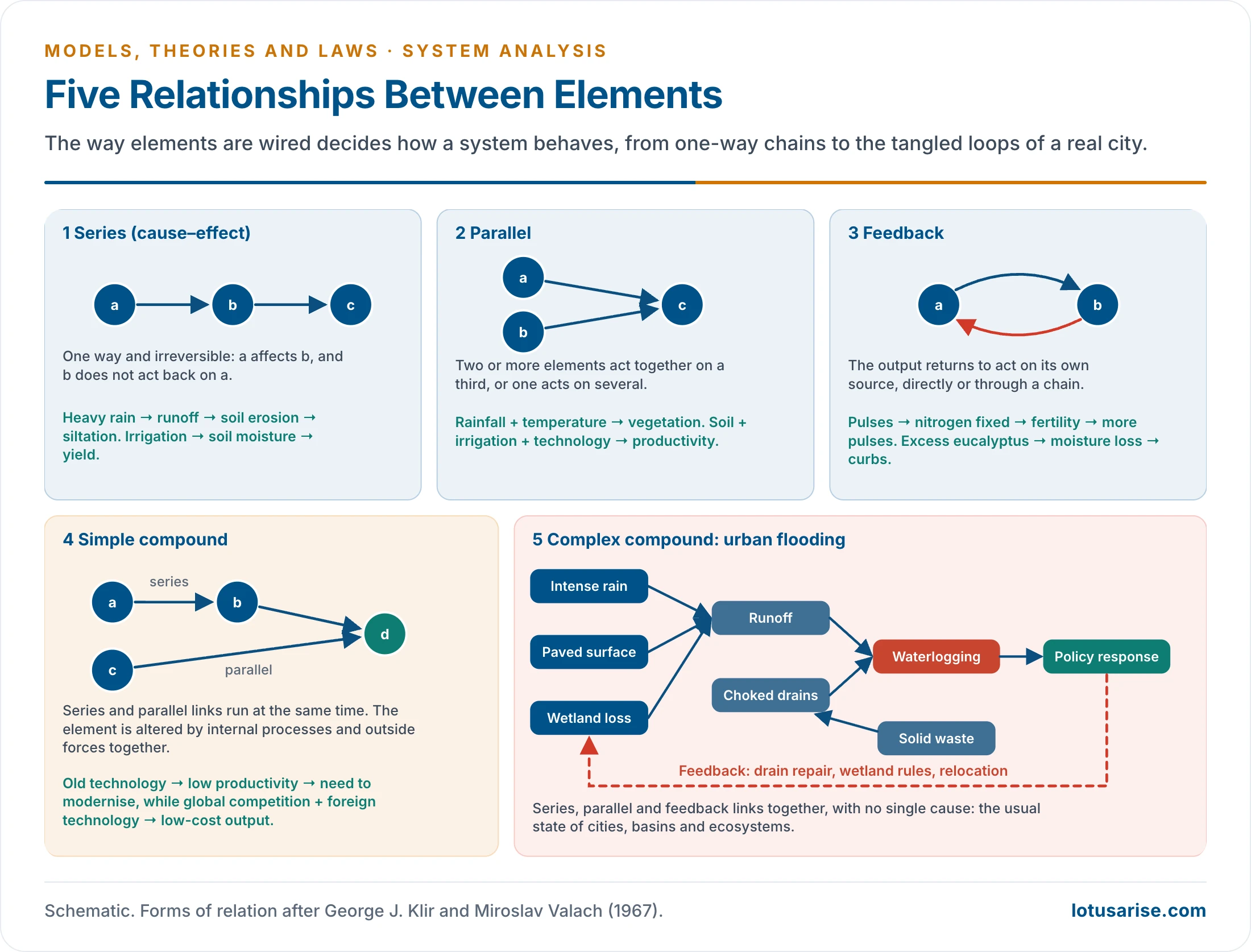
- A system is understood by how its elements are connected, not by the list of elements. Links may be simple or complex, one-way or reciprocal, visible (a road) or hidden (market demand on crop choice). George J. Klir and Miroslav Valach (1967) gave the standard forms, which combine like a wiring system.
Series (Cause–Effect) Relationship
- The simplest form. Elements are joined in sequence and the link is one-way and largely irreversible: A → B → C.
- Examples:
- Heavy rain → surface runoff → soil erosion → siltation. Erosion does not act back on rainfall in the same chain.
- Irrigation → soil moisture → agricultural productivity. Irrigation drives Punjab’s rice, not the reverse. Regur favours cotton, and cotton does not make the soil black.
- It suits many physical and economic processes, but it simplifies, since few real systems are purely linear.
Parallel Relationship
- Two or more elements jointly affect a third, or one element affects several. The affected element may later act back indirectly.
- Examples:
- Rainfall + temperature → vegetation, and vegetation → local humidity and micro-climate.
- Soil fertility + irrigation + technology → productivity.
- It is more realistic than a series, since outcomes in farming, climate, population and regional development rarely have one cause.
Feedback Relationship
- The output returns to influence its own source, so elements affect each other mutually.
- Example: pulses → nitrogen fixation → soil fertility → higher pulse output. Its two kinds are compared below.
Simple Compound Relationship
- Series and parallel relations operate together. Components are changed by their own internal processes and also by outside forces.
- Examples:
- Indian industrial modernisation: old technology → low productivity → need to modernise, while global competition + foreign technology → low-cost output. Internal pressure and external influence act at once.
- Plant growth: solar energy acts in series, while soil fertility and water availability act in parallel.
Complex Compound Relationship
- Series, parallel and feedback relations combine, with internal and external elements influencing each other. It is the most realistic form and the hardest to analyse, because no single cause can be isolated, and a change in one element can return to alter it.
- Urban flooding: heavy rain → runoff → waterlogging; urbanisation → impervious surface → more runoff; wetland loss → less absorption → worse floods; solid waste → blocked drains; flooding → policy → drainage works or relocation.
- Ecosystem: deforestation alters runoff, erosion, biodiversity, local temperature, rainfall and livelihoods, and these changes alter human decisions and recovery.
- Metropolis: population, land prices, routes, jobs, housing, pollution, migration, governance and technology interact continuously, so urban problems need integrated planning, not single-factor fixes.
- Such relations are the most common in geography: the human body, metro cities, river basins, ecosystems, migration systems and regional economies all show them. This is why system analysis matters for applied work.
Two Kinds of Feedback
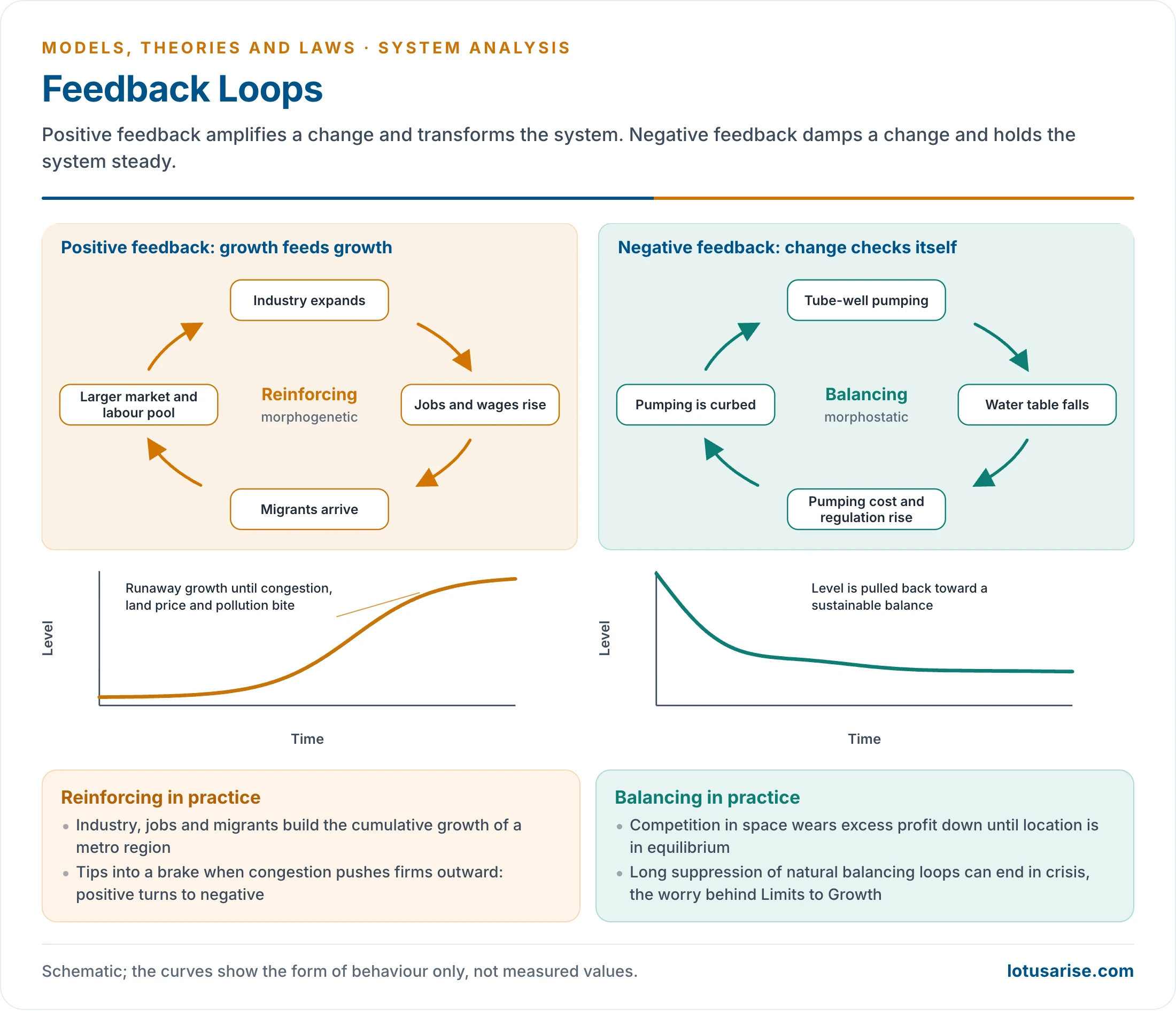
- Feedback is central to cybernetics, because it makes systems self-adjusting, self-reinforcing or self-correcting. It may be direct (A acts on B, B on A) or indirect (the impulse returns through a chain).
| Type | Effect | System state | Examples |
|---|---|---|---|
| Negative | Checks the process, restores balance | Morphostatic, homeostatic | Water-use limits and recharge when groundwater falls; spatial competition wearing down excess profit; eucalyptus → moisture loss → lower yield → curbs on planting |
| Positive | Reinforces the process | Morphogenetic, changing form | Industrial growth → jobs → migration → urban growth → more industry |
- One loop can turn into the other: when congestion, pollution and land prices rise sharply, industry moves outward. This is the same logic as cumulative causation in migration.
- Technological positive feedback has driven exponential growth in population and output. Scientists fear that long suppression of natural negative feedback could end in crises of pollution, hunger and resources, the concern of Limits to Growth.
Applications in Human Geography
Geographical Systems
- A geographical system is one whose important functional variables are spatial: location, distance, extent, density per unit area.
- Such a system combines structure in space with function through flows. Walter Christaller’s central places, read this way, are a system in which higher-order centres give specialised services to wide hinterlands and lower-order centres give basic services to small areas.
- Berry’s city systems treat a city as a system whose environment is the wider hierarchy of cities. Those who study spatial organisation invariably invoke systems, as locational analysis shows.
| Branch | System analysis helps study | Indian example |
|---|---|---|
| Urban | Growth, commuting, transport, solid waste, air pollution, urban heat island, housing demand, city–region links | Delhi NCR: Delhi, Gurugram, Noida, Ghaziabad and Faridabad as nodes joined by labour, capital, real estate, transport and services |
| Settlement | Village–town links, central place hierarchy, service centres, market areas, functional regions, rank-size | Rural service centres and market towns tied to district headquarters |
| Population | Transition, migration streams, population–resource relations, urban growth, regional imbalance | Out-migration from Bihar and eastern Uttar Pradesh, tied to agrarian stress, wages, labour demand, networks, connectivity and remittances |
| Economic | Industrial location, input–output, regional planning, growth poles, commodity chains, market areas | Chennai’s automobile cluster: ports, highways, skills, suppliers, global firms, state policy, logistics, export markets |
| Agricultural | Crop combination, land-use change, command areas, Green Revolution regions, food security, climate-resilient farming | Punjab: canals and tube-wells, MSP procurement, HYVs, fertiliser, mechanisation, paddy–wheat, groundwater depletion |
| Political | Borderlands, federal relations, alliances, electoral geography, resource conflict | India–Bangladesh borderland: boundary, migration, trade, rivers, cultural continuity, security, border infrastructure |
| Regional planning | Backward regions, resource potential, growth-centre links, infrastructure gaps, corridors, balanced development | Aspirational districts: health, education, agriculture, skills, infrastructure, governance |
| Environmental | Watersheds, climate adaptation, disaster risk, pollution, ecosystem services, carrying capacity, EIA | Brahmaputra floods: rainfall, snowmelt, sediment, morphology, embankments, land use, settlement, governance |
- Regional planning gains most, since a region is a multi-variable system. Planners can read backwardness, resource potential and corridors together instead of one sector at a time.
- Practical use needs no heavy mathematics. Naming the elements, links, flows and controls already clarifies a problem such as Punjab’s groundwater or Delhi’s air.
Urban Planning as a System
- J. Brian McLoughlin (1969) and George Chadwick (1971) recast town planning as the guidance and control of a complex system, using general system theory and cybernetics. Jay W. Forrester’s Urban Dynamics (1969) simulated the city through feedback loops.
- Why it matters in planning:
- The city is an open, complex system, so land use, transport, housing, water and waste must be planned together.
- Land use and transport form a feedback cycle: land use creates trips, trips load the network, the network sets accessibility, and accessibility reshapes land use.
- It exposes side effects, for example a new road that draws more traffic.
- It fixes the right boundary. Delhi’s air could not be managed within the city, hence the Commission for Air Quality Management in NCR and Adjoining Areas (2021).
- It allows scenario testing. The NCR Planning Board’s transport model compared development scenarios for 2032.
- It joins sectors and levels, from ward to metropolitan region, which a static land-use master plan does not.
- It supports monitoring and control. All 100 Smart Cities had an Integrated Command and Control Centre by the mission’s financial closure on 31 March 2025 (MoHUA).
- Its limits:
- Douglass B. Lee (1973) argued that large-scale urban models had met none of their goals.
- Horst Rittel and Melvin Webber (1973) called planning problems wicked: ill-defined, without a stopping rule, and with answers that are good or bad rather than true or false.
- Goals and values are contested, so planning cannot be reduced to engineering.
- Informal housing, jobs and transport escape the data. Plans also tend to underplay class power, speculation and eviction.
- Indian cities add fragmented authority, with land, transport, water and housing under different bodies, and weak ward-level data between censuses.
- In practice the approach survives in humbler form. Indian Comprehensive Mobility Plans build a four-stage travel model, set a business-as-usual scenario against a sustainable one, and then choose a package of measures.
Method of System Analysis
| Step | Example: urban water scarcity |
|---|---|
| 1. Define the problem | Why is the city short of water? |
| 2. Delineate the boundary | Municipal area, metropolitan region or river basin? |
| 3. Identify elements | Sources, population, industries, network, rainfall, groundwater, governance |
| 4. Identify flows and links | Supply, wastewater, finance, demand, policy decisions |
| 5. Measure variables | Per capita availability, water table, leakage, demand–supply gap |
| 6. Construct a model | Water balance or GIS-based water system model |
| 7. Analyse feedbacks and thresholds | Over-extraction lowering the water table; tanker dependence deepening inequality |
| 8. Predict scenarios | Demand under different population and rainfall conditions |
| 9. Suggest intervention | Rainwater harvesting, wastewater reuse, aquifer recharge, demand management |
System Analysis and the Unit’s Models
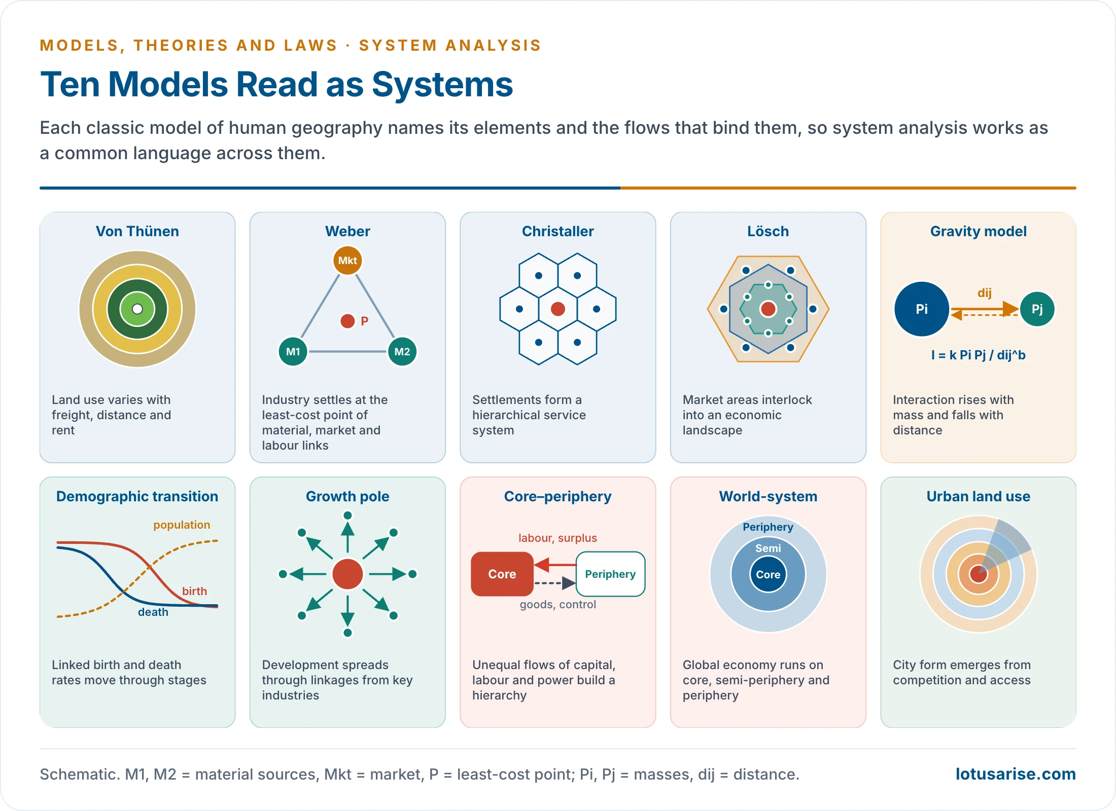
- System analysis works as a meta-framework connecting models, theories and laws.
| Model | System logic |
|---|---|
| Johann Heinrich von Thünen | Land use varies with freight, market distance and rent |
| Alfred Weber | Location depends on material, market, labour and transport links |
| Walter Christaller and August Lösch | Settlements form a hierarchy; landscapes emerge from market areas |
| Gravity model | Interaction depends on mass and distance |
| Demographic transition | Linked fertility and mortality move through stages |
| Growth pole | Development spreads through linkages from propulsive industries |
| Core–periphery | Unequal flows of capital, labour and power build a hierarchy |
| World-system | The global economy runs on core, semi-periphery and periphery |
| Urban land-use models | City form emerges from competition, access and social process |
Evaluation and Relevance
Importance
- System analysis turned geography from a descriptive discipline into an analytical and applied one.
- Holistic: it studies the whole, since geographical problems are multi-dimensional. Urban pollution is tied to transport, industry, density, energy, governance and lifestyle, not to the environment alone.
- Interdisciplinary: it joins physical and human geography, economics, sociology, political science, ecology and planning.
- Predictive: urban growth simulation, flood forecasting, traffic modelling, population projection, land-use change modelling.
- Policy-relevant: regional development, smart cities, watersheds, disaster management, EIA, transport and climate adaptation.
- Reveals unintended effects: many policies fail because they ignore feedback. Subsidised farm power raises irrigation, but also depletes groundwater, distorts cropping and strains budgets.
- Simulation: planners can try changes on a model before trying them on a city or a basin.
- Technical base: GIS modelling, spatial decision support and urban analytics rest on system thinking.
- Theory-building: it gives a common language for elements, links, flows, function and development, moving geography from description to objective interpretation.
- Handles complexity: feedback, threshold, equilibrium, hierarchy and control are tools for complex structures.
Criticism and Limitations
- Quantification bias: measurable variables come first, so emotion, culture, power, identity and perception may be lost.
- Mechanistic view: societies are not machines, and behavioural and humanistic geographers object to the loss of human agency.
- Boundary problem: Mumbai may be a municipal, metropolitan, coastal, financial or global-city system.
- Data constraints: gaps, informal economies and unrecorded flows hamper developing countries.
- Non-linearity: real systems do not respond in proportion. A small blocked drain can flood a district, while a large project may fail if behaviour is ignored.
- Neglect of power: radical geographers ask who controls the system and who benefits. Land-use models may underplay class power, speculation, eviction and informality.
- Positivist bias: reality is assumed to be objectively measurable, so unseen variables drop out, and geography risks becoming a space geometry.
- Human values: beliefs, attitudes, hopes, fears and ethics resist quantification, which is why humanist and welfare approaches reject it as an incomplete picture.
- Technical demand: abstract mathematics limits its use in field and qualitative work and has attracted fewer researchers.
- Not always needed: it may systematise models, yet a world map of iron ore trade can be read in system terms without the mathematics.
Contemporary Relevance
- System analysis has grown more relevant because geographical problems are more interconnected than ever: climate adaptation, urban resilience, disaster risk, the SDGs, the food–water–energy nexus, circular economy, regional inequality, supply chains, migration and remittance networks, and pandemic geography.
- COVID-19 showed health, migration, transport, economy, governance and density to be one socio-spatial system.
- Climate change is tied to energy, agriculture, urbanisation, geopolitics, technology, consumption and vulnerability.
- Newer forms of the idea:
- Earth system science treats atmosphere, oceans, ice, land and life as one system. Planetary boundaries (Johan Rockström and others, 2009) apply it to the limits of human pressure.
- Resilience thinking, from C. S. Holling (1973), asks how a system absorbs shocks instead of assuming one equilibrium.
- Complexity science sees cities as growing from the bottom up, not as machines under control.
- Urban digital twins are live virtual copies of a city. India’s National Geospatial Policy 2022 aims at a National Digital Twin of major urban centres by 2035, and PM GatiShakti (2021) puts infrastructure layers on one GIS platform.
Indian Systems
| System | How it works as a system |
|---|---|
| Delhi NCR | Urban nodes linked by transport, labour, real estate and services. Air pollution involves crop residue burning, vehicles, dust, industry, meteorology and regional governance |
| Punjab agriculture | Paddy–wheat tied to MSP, procurement, groundwater, power subsidy, mechanisation, migrant labour and soil decline. Changing crops needs market, irrigation, incentive and demand changes together |
| Himalaya | Geology, slope, rainfall, glaciers, rivers, roads, tourism, hydropower and settlements. Landslides and flash floods arise from their interaction |
| Mumbai Metropolitan Region | Monsoon rain, tides, drainage congestion, reclamation, wetland loss, informal settlements, real estate pressure and fragmented governance |
| Aspirational Districts | Backwardness read as a multi-sector system of health, nutrition, education, agriculture, water, infrastructure, financial inclusion and governance |
Summary
| Category | Details |
|---|---|
| Founder | Ludwig von Bertalanffy (1901–1972), general system theory |
| Allied field | Cybernetics: Norbert Wiener (1948) |
| Entry into geography | Richard J. Chorley (1962), Brian J. L. Berry (1964), during the quantitative revolution |
| Parts | Elements, attributes, links, flows, boundary, environment, input, throughput, output, feedback, control |
| Types | Open, closed, isolated; morphological, cascading, process–response, control; homeostatic, dynamic, adaptive, controlled, partially controlled |
| Relationships | Series, parallel, feedback, simple compound, complex compound |
| Main critique | Quantification, mechanistic view, boundary problem, neglect of power and values |
| Value today | Urban planning, climate and Earth system science, resilience, digital twins |
Previous Year Questions
2025Why is systems analysis important in urban planning and what are its limitations?2017Write an explanatory note on geographical systems.2014Giving suitable examples, describe the importance of system analysis in geographical studies.2011Discuss Systems Approach and its applicability in Geography.2001Discuss the concept and application of systems analysis in Human Geography.1993Write short note: System approach in Geography.1987Write short note on Systems approach in geography.





Thank you
Very helpful, very informative. Thank you.
thank you so much LR
Keep Reading
Thank you so much … I have no word to Say thanks … Very impressive initiative for those who don’t join paid classes
Thank you so much for the kind words! Knowing this helps you in your journey and makes it all worthwhile. Keep learning and all the best!
Very meaningfull for my study . Thank you
You are amazing
Thank you so much! That really means a lot, especially when breaking down tricky topics like human geography perspectives and models.
Hearing that the notes are making a difference in your preparation is the best motivation. Keep pushing forward, and happy learning!
I think you are underrated!🤣🤣
Haha, I appreciate that!
It’s amazing. 1st time i felt that I can deal with human geography.. Esp perspective and models etc.
Thank you so much! Making these complex topics easier to handle is exactly what we aim for. Happy learning!
pls also add source of the content….. book u used …
Models in GEOGRAPHY by Majid Husain