

Hierarchy of Urban Settlements

- The hierarchy of urban settlements refers to the ranked order in which cities and towns are organised based on their size, population, functions, and level of services.
- It is a system in which urban centres are classified into different levels — from the smallest hamlet to the largest megalopolis — with each level serving a wider hinterland and providing a greater variety and complexity of services than the one below it.
- In geography, the study of urban hierarchy is fundamental to understanding how settlements are spatially organized, how they interact with each other, and how services and functions are distributed across an urban system. The concept rests on a simple but powerful observation:
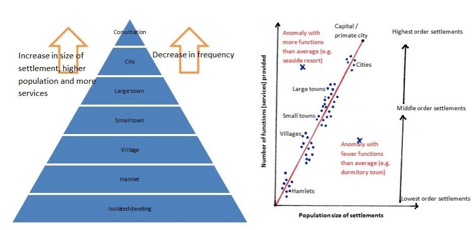
- As settlements grow larger, the number and complexity of their functions increase.
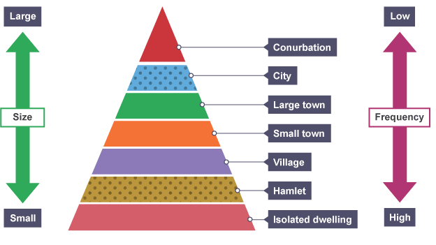
- Larger settlements are fewer in number but serve larger surrounding areas.
- Smaller settlements are greater in number but serve only local needs.
- The distance between settlements of the same size tends to increase as settlement size increases.
- Each level of the hierarchy depends upon, and interacts with, the levels both above and below it.
- The concept was first systematically studied by German geographer Walter Christaller in 1933 through his Central Place Theory, which remains the most influential theoretical framework for understanding how hierarchies of settlements form and function. His work was later extended by economist August Lösch (1940) and the urban continuum model was given a statistical foundation by G.K. Zipf (1949) through the Rank-Size Rule.
Levels of the Urban Hierarchy
- The concept of the Urban System was introduced by Brian J.L. Berry (1964) in his noteworthy work “Cities as systems within systems of cities”.
- Urban places do not exist in isolation. There is a whole series of different types of relationships between separate towns and cities, and we use the term urban system to indicate that the individual urban centres are linked to each other. An urban system is defined as any network of interdependent urban places.
- The urban hierarchy concept considers that the urban places vary in population sizes and economic functions.
- The analysis of urban hierarchy mainly relates to the ranked order of cities based on different criteria, such as population size, economic power, retail sales, and the number of industrial workers.
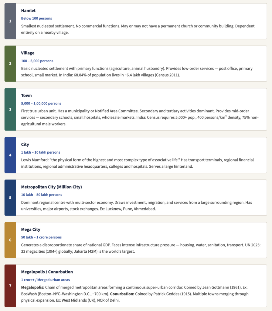
- Urban settlements are organized into a continuum from the smallest to the largest, with each level representing a qualitative jump in function, population size, and sphere of influence. The standard levels recognised in Settlement Geography are:
- Hamlet
- Village
- Town
- City
- Metropolitan City (Million City)
- Mega City
- Megalopolis / Conurbation
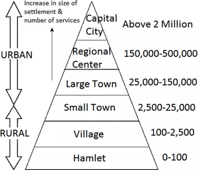
- As you move up the hierarchy, settlement size increases, number of settlements decreases, distance between same-order settlements increases, range and variety of services increases, and the sphere of influence (hinterland) expands. This is the fundamental logic articulated by Christaller’s Central Place Theory.
- Polis is a successful village(town) that has just become an urban center.
- Eopolis, as Polis grows and develops into a bigger town.
- Metropolis, not just one city with contiguous towns, cities, and conurbations made up of villages, economically and socially integrated with strong functional linkages.
- Tyrranopolis is where life becomes miserable due to inadequate services and civic amenities.
- Nekropolis is where cities are abandoned turned into ‘ghost cities’, deurbanization takes place.
- Megalopolis is a chain of urban cities/centres, a characteristic feature of the USA(Philadelphia-New York-Boston), Japan(6 million-plus cities Tokyo, Osaka, Kobe, etc..)
- In India potential of Megalopolis between Mumbai-Ahmedabad encompassing Surat, Vadodara, Anand, etc.,
Hierarchy Based on Administrative Regions

Determinants of Position in the Urban Hierarchy
- A settlement’s position in the urban hierarchy is not determined by population alone. Multiple factors interact to define where a city sits relative to others:
- Population Size
- The most direct indicator. Larger populations support a wider range of services and attract more investment, reinforcing growth.
- Economic Functions
- Diversity and sophistication of economic activities — from primary extraction to advanced finance, IT, and research — determine functional rank.
- Administrative Role
- National capitals, state capitals, and district headquarters gain hierarchical advantage through political power, resource allocation, and policy priority.
- Transport Connectivity
- Nodal positions on road, rail, air, and waterway networks increase a city’s accessibility, expanding its hinterland and boosting its hierarchical position.
- Infrastructure Quality
- Healthcare, education, utilities, and housing quality attract skilled workers and businesses, elevating the city’s rank over time.
- Historical & Colonial Legacy
- Port cities like Mumbai, Kolkata, and Chennai gained permanent hierarchical advantages from colonial-era investment in trade infrastructure.
- Population Size
The Indian Urban Hierarchy — Structure and Imbalances
India’s urban system is one of the most complex in the world — shaped by the interplay of colonial history, federal politics, vast geography, and rapid recent urbanization. Understanding its hierarchy is essential for UPSC Geography Optional.
India’s Urban Classification System
| Class | Population Range | Examples |
|---|---|---|
| Class I (Urban Agglomerations) | 1,00,000+ | Delhi, Mumbai, Bengaluru, Hyderabad, Chennai, Kolkata |
| Class II | 50,000 – 99,999 | Muzaffarnagar, Shimla, Berhampur |
| Class III | 20,000 – 49,999 | Meerut (before growth), smaller district towns |
| Class IV | 10,000 – 19,999 | Most tehsil headquarters |
| Class V | 5,000 – 9,999 | Larger Census Towns |
| Class VI | Below 5,000 | Statutory towns at smallest end |
Structural Pattern of the Indian Urban Hierarchy
- The Indian urban system is characterized by a few very large cities and a very large number of small towns — the classic inverse pyramid of settlement hierarchy.
- Million-plus cities (Class I UAs) form the apex of the pyramid and account for over one-third of India’s total urban population, despite being small in number.
- In 1901, 48.73% of urban population lived in towns with less than 20,000 people; by 1991 this had fallen to just 10.66% — showing the dramatic concentration at the top of the hierarchy.
- India’s urbanization is characterized as “poly-metropolitan” — dominated by four premier cities (Mumbai, Kolkata, Delhi, Chennai) that together exert a pull far exceeding any other urban centres.
- Small and medium towns have been relatively stagnating while mega cities have experienced explosive population growth — indicating a break and imbalance in the urban hierarchy continuum.
Is India a Primate City Country?
- India does not have a single national primate city. This is because India’s large territorial size, its colonial history (multiple port cities — Mumbai, Kolkata, Madras — were all developed simultaneously), and its federal political structure prevent one city from dominating all others nationally.
- However, regional primacy is clearly evident: Kolkata dominates the Eastern region (was almost 7× larger than the 2nd largest eastern city until 2001), Mumbai dominates the Western region, Delhi dominates the Northern region. Primacy exists in at least 15 of India’s 29 states. The Southern region is the exception — no primacy, as Chennai, Bengaluru and Hyderabad have competed closely.
Rank-Size Rule — Is it Applicable to India?
- The rank-size rule is absent at the national level in India — the populations of Mumbai, Kolkata, and Delhi are very close to each other, violating the expected smooth logarithmic decline.
- A great majority of Indian states also do not conform to the rank-size rule.
- The rapid urbanization of smaller cities (IT boom driving Bengaluru, Pune, Hyderabad) is creating a more complex pattern that is neither classic primate nor classic rank-size.
- India’s urban system is described as not integrated both functionally and spatially — there are “breaks and imbalances” in the urban hierarchy and the rural-urban profile (Rama Baru).
Colonial Roots of India’s Urban Imbalance
- The British deliberately developed three port cities (Bombay, Calcutta, Madras) as administrative, commercial, and industrial hubs for the purpose of resource extraction and maritime trade.
- This colonial spatial imprint created a top-heavy urban hierarchy with very large primate cities at the top and poorly developed intermediate cities below them.
- Delhi’s growth as a primate city of the North accelerated after it became the capital of British India in 1911 and was further reinforced after independence in 1947.
- The result: India’s urbanization has been described as “subsistence urbanization” — rural workers migrate to cities not for opportunity but for survival, creating vast informal settlements and slums rather than productive urban growth.
Significance of Studying Urban Hierarchy
- Regional Planning
- Identifies gaps in the service hierarchy — regions with missing intermediate cities need new growth centres. Guides placement of new towns, industrial corridors, and satellite cities.
- Infrastructure Investment
- Helps decide where to locate hospitals, universities, and transport hubs based on the threshold populations of different urban levels, maximising reach and efficiency.
- Migration Management
- Understanding why rural migrants bypass small towns to reach mega cities helps design incentives for developing intermediate cities — reducing pressure on metros.
- Sustainable Urbanization
- A balanced urban hierarchy — with well-developed towns, secondary cities, and metro areas — is more resilient, equitable, and environmentally sustainable than a primate-dominated system.
- Sphere of Influence
- Defines each city’s functional hinterland — essential for delineating planning regions, market areas, and administrative jurisdictions at every level of governance.
- Policy Relevance — India
- India’s Smart Cities Mission (100 cities), AMRUT (500 cities), and PM Gati Shakti (multimodal connectivity) all aim to correct the imbalances in India’s urban hierarchy by developing secondary and tertiary cities.
Criticisms and Contemporary Relevance
Criticisms of Traditional Urban Hierarchy Models
- Overemphasis on economic rank — Traditional hierarchy models measure cities only by population size and economic output, ignoring quality of life, liveability, and social equity.
- Static models — CPT and the Rank-Size Rule are essentially static; they do not explain how hierarchies change over time due to technological shifts, policy interventions, or disasters.
- Inapplicable to developing world — Models built on assumptions of developed, market-economy plains are poorly applicable to India, Sub-Saharan Africa, or Southeast Asia — where political, colonial, cultural, and topographic factors heavily distort the ideal hierarchy.
- Neglect of non-market functions — Religious towns (Varanasi, Mecca), educational towns (Oxford, Aligarh), and defence towns do not fit neatly into market-based hierarchies.
- Globalization blurring hierarchies — Global cities (Sassen, 1991) like New York, London, and Tokyo interact more with each other across the world than with their immediate national hinterlands — suggesting a new “transnational” tier above the traditional national hierarchy.
Contemporary Shifts in Urban Hierarchy
- Rise of secondary cities — IT-driven growth of Bengaluru, Pune, Hyderabad, and Gurugram in India is creating a more balanced upper tier in the national urban hierarchy.
- Post-COVID dispersal — Remote work has enabled population dispersal from mega cities to smaller towns, potentially flattening hierarchies in developed countries.
- Digital connectivity — E-commerce, telemedicine, and online education allow smaller towns to access services previously available only in large cities — reducing the functional gap between hierarchy levels.
- New capital cities — Indonesia’s Nusantara, Egypt’s New Administrative Capital — deliberate state-level disruptions to existing urban hierarchies.
The Future of Urban Hierarchy
- Scholars argue the rigid urban hierarchy is becoming less relevant in the 21st century. Smaller towns gain global connections through digital networks; regional centres face problems previously only associated with megacities.
- The need is for a more nuanced approach that treats all urban settlements as communities for human flourishing — not merely as rungs on an economic ladder. India’s National Urban Policy framework (2018) explicitly recognizes the need to develop a balanced urban system across all settlement sizes.
Conclusion
- The hierarchy of urban settlements is not merely a geographic classification — it is a reflection of the economic, political, historical, and cultural forces that have shaped human civilization. From Christaller’s elegant hexagons to Zipf’s statistical law to Jefferson’s primate city, geographers have consistently sought to find order in the way human beings organize their collective life in space.
- For India, understanding the urban hierarchy is not an academic exercise — it is a developmental imperative. A country where mega cities overflow with migrants while small towns stagnate, where colonial port cities still anchor regional economies a century after independence, and where hundreds of millions await the basic services that a well-functioning urban hierarchy would deliver to every level — understanding this hierarchy is the first step toward reforming it.
- The goal, as articulated by India’s urban planners and the United Nations SDG 11 (Sustainable Cities), is a balanced, inclusive, and resilient urban hierarchy — one in which every settlement, from the humblest village to the largest metropolis, fulfils its proper role in the integrated system of human settlement.





Tnq so much 💕💕💕
do you provide hard copy of notes or just the pdf form ???
Only PDF!
Thank you Sir