

Central Place Theory of Christaller and Losch

- The Central Place Theory (CPT) is a geographical theory that explains the size, number, spacing, and functional hierarchy of human settlements in a region.
- It was formulated by German geographer Walter Christaller in 1933 and remains “the single most important basis for analysing settlement systems.”
- The theory proposes that settlements develop in a hierarchical system in which larger central places provide more complex goods and services over a wider tributary area, while smaller central places provide only basic goods and services to a smaller local area.
- Central Place Theory belongs to the Locational Triads of the Quantitative Revolution in Geography — alongside Von Thünen’s Agricultural Location Theory (1826) and Alfred Weber’s Industrial Location Theory (1909).
- It is the only one of the three that deals with settlements rather than individual economic activities, making it uniquely comprehensive in its spatial scope.
- CPT is a deductive theory — it builds from first principles and assumptions to derive conclusions, rather than inductively generalizing from observed patterns.
- The theory treats settlements not in isolation but as parts of an integrated spatial system — the settlement system — in which each place has a role, a rank, and a service area relative to all others.
- It eliminates the rural-urban dichotomy — all settlements, from the smallest hamlet to the regional capital, are considered part of a single continuum ordered by function. This makes CPT “the most complete theory in settlement study till now”.
- The theory links directly to the concepts of sphere of urban influence (the complementary region), urban hierarchy (the ordering of central places by function), and functional classification of cities (the basis for ranking settlements).
- It is concerned with the way the settlements evolve and are spaced out. It seeks to discover an order in size & spacing of settlement and functional relation between them i.e. Settlements size & its position in hierarchy, functional relation with other settlements, etc
- It seeks to find whether the spacing of settlements is arbitrarily located or if there is any logic or justification behind the order in size and spacing of settlements
Christaller’s Intellectual Journey
- Walter Christaller (1893–1969) was a German geographer whose doctoral thesis, Die Zentralen Orte in Suddeutschland (Central Places in Southern Germany), written in 1933 and translated by C.W. Baskin in 1955 (published in 1996), laid the foundations of Central Place Theory.
- The book was first systematically studied in the English-speaking world only after the quantitative revolution in geography in the 1950s–1960s, when it rapidly became one of the most influential works in the entire discipline.
- Christaller’s primary question was: Why do towns of different sizes exist? What determines the number and location of towns in a region?
- He observed that in the relatively flat, agriculturally uniform landscape of Southern Germany, there seemed to be a regularity in the size, spacing, and distribution of towns — some were close together, others far apart; some were large with many functions, others small with few.
- He concluded that this regularity was not accidental — it reflected a fundamental economic logic of service provision and market optimization.
- The core idea: a certain amount of productive land supports a settlement, which in turn provides essential services to that land — referred to as its complementary area, also called the tributary area or service area. The settlement itself is the central place.
- Christaller observed that the essence of a city’s existence is not that it is a place of production, but that it is a central place providing services (central goods and services) to a surrounding hinterland — this is what makes a settlement urban in character, regardless of its size.
- In his view, even modern cities follow a centralistic pattern — not through visible physical symbols like forts (as in medieval towns), but through their chief profession or dominant function which makes them service centres to their rural hinterlands.
Assumptions
- CPT is a deductive theory built on a carefully specified set of assumptions. Some are explicitly stated; others are implicit.
- Isotropic Plain (Limitless Homogeneous Surface): The area under study is topographically a plain with uniformly productive soil and no physical barriers (mountains, rivers, coasts) that would alter transport routes. Transport cost is equal in all directions.
- Evenly Distributed Rural Population: The population is uniformly spread across the plain — no clustering, no voids. This ensures that the spatial patterns of service provision emerge purely from economic logic, not from pre-existing population concentrations.
- Uniform Transportation: Homogeneous transport services enable a person to move in any direction with equal ease and at equal cost. Distance is the only friction — there are no modal differences.
- Economically Rational Consumers: All consumers are “commercially motivated economic men” interested in maximizing their utility. They will always purchase goods and services from the nearest available central place — distance minimization is universal.
- No Economic Disparity: There exists no economic disparity due to the localization of resources or technology. All areas have the same purchasing power and production possibilities.
- Tertiary Activity as Driver: The evolution of the economic landscape depends on the development of tertiary activities — the provision of goods and services. Manufacturing and primary activities are abstracted away.
- Demand = Distance: When demand for a certain good is high, it will be offered in close proximity to the population. When demand drops, supply or availability drops correspondingly — giving rise to geographic variation in service provision.
- The region is isolated i.e., the landscape understudy is isolated & has no connection with the rest of the world.
- The entire landscape of settlements is to be fully served by a set of uniformly spaced central places.
- All settlements are point occupying i.e. Metropolis or Normal City, town or hamlet, all occupy the equal area. The settlement distribution is uniform with respect to resources.
Objectives
- It consists of 2 theories
- W. Christaller Theory (1933)
- August Losch Theory (1940)
- Christaller’s theory was based on his empirical studies of settlements in South Germany
- CPT is a theory that tries to suggest that under ideal normative conditions or perfect conditions, what can be the best number of levels in which urban hierarchy can be dissolved (Tier 1, Tier 2, Tier 3 towns etc), the number of settlements in each hierarchy, their location & spacing and ideal shape of their influence area (circular, hexagonal, etc)
- Since it is a normative model, it can be used for planning
Core Concepts of Central Place Theory
- The Fundamental Concepts on which CPT is based are
- Principle of Centralization
- Principle of Hierarchy
- These principles govern the structure of all phenomenon.
Principle of Centralization
- Similar to all matter, all regions have a core and peripheral areas
- e.g. The village has its core around a temple, mosque, church, chaupal, etc
- e.g. Small towns serve as a core for several villages and hamlets
- It is not necessary that the core/focal point has to be at the geometric centre of the settlement
- Centralization is, thus, not a geometrical concept rather a concept concerning the relationship between a central and peripheral settlement
Principle of Hierarchy
- Similar to most phenomena arranged in a hierarchical fashion, Hierarchy also manifests itself in terms of territorial divisions and places
- e.g. State, District, and Tehsil complemented by place hierarchy of State capital, District headquarter and Tehsil headquarter

The theory is based on 6 Derivative Concepts
- Concept of Central Place
- Concept of Central Place function
- Concept of Centrality
- Concept of Complementary Area
- Concept of Threshold Population
- Concept of Range of Goods & Services
1. Concept of ‘Central Place‘
- A central place is a settlement that provides goods and services not only to its own population but also to the population of other neighbouring settlements — i.e., it serves a territory larger than its own footprint.
- Every settlement, from the smallest weekly market hamlet to the largest metropolis, qualifies as a central place at its respective hierarchical level.
- The term was first used by Mark Jefferson in 1931.
- It is the focus point to all surrounding regions such as
- Around a village – Town
- Around a large town, or medium city – Metro City
- Around a metro city – Capital city
- Any yearly or weekly market do not serve as a focal point rather a permanent settlement or establishment.
- Central Place is characterized by maximum pull & a high degree of functionality (e.g. Transport, Health, Education, etc).
- It is at the helm of affairs.
- In the theory, Central Place is depicted by a single dimensionless point.
- However, all urban places are not necessarily urban places e.g. A mining town or manufacturing town is not a central place, unless it has some tertiary activities catering to needs of surrounding villages.
2. Concept of ‘Central Place Function‘
- These are the set of Goods & Services offered by Central Place. A central place offers more than one central place functions & all the functions are not of same hierarchical order rather some of them are of higher hierarchy & some of lower hierarchy (e.g. Supreme Court has a higher hierarchy and it is located in Delhi).
- Christaller distinguished between three types of goods and professions based on where they are produced and offered:
- Central goods and services (Central Professions) — Goods and services produced or offered at the central place. These are the defining characteristic of a central place. Examples: administrative services, airports, specialist hospitals, universities, financial institutions.
- Dispersed goods and services — Produced or offered at dispersed locations, not concentrated in a central place. Examples: agricultural products, forestry outputs, small-scale home industries.
- Indifferent goods and services — Found everywhere with uniform distribution. Examples: basic utilities, roadside petty shops, common daily necessities.
- British geographers divided goods into rural and urban, but Christaller avoided this dichotomy — his system operates on a continuum. Following Alfred Weber’s terminology, central goods can be:
- Consumer-oriented — located near consumers (e.g., breweries).
- Raw-material-oriented — located near inputs (e.g., dairies, sugar refineries).
3. Concept of ‘Centrality‘
- Centrality refers to the relative importance of a central place which is dependent on the Central Place functions that it offers such as
- Number of Goods & Services
- Variety of Good & Services, and
- Order of function
- Those which provide higher order function have high centrality whereas those which provide lower order function have low centrality
- Centrality of a central place is not on the basis of its location (Central Place is never the geometric centre)
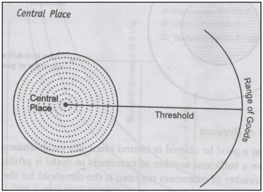
4. Concept of ‘Complementary Area‘
- The complementary region (also called Ergansungsgebiet in German — supplementary or complementary region) is the area of productive land surrounding a central place that the central place serves and that in turn supports the central place economically. It is also called the tributary area or service area.
- The extent of the complementary region varies with the size (i.e., functional complexity) of the central place — not merely with its population.
- A large complementary region will include several smaller ones — smaller central places depend on larger ones for higher-order functions. This creates a nested hierarchy of service areas.
- Lower-order central places are called Importance-Deficit Regions, while higher-order central places are Importance-Surplus Regions.
- As the hierarchy of central places emerges through nesting, the largest settlement in the system becomes the regional capital and the entire region falls within its complementary area.
- At each level of the hierarchy, the sizes of tributary areas remain equal and are placed side by side. Central places of the same order are found equidistant from each other.
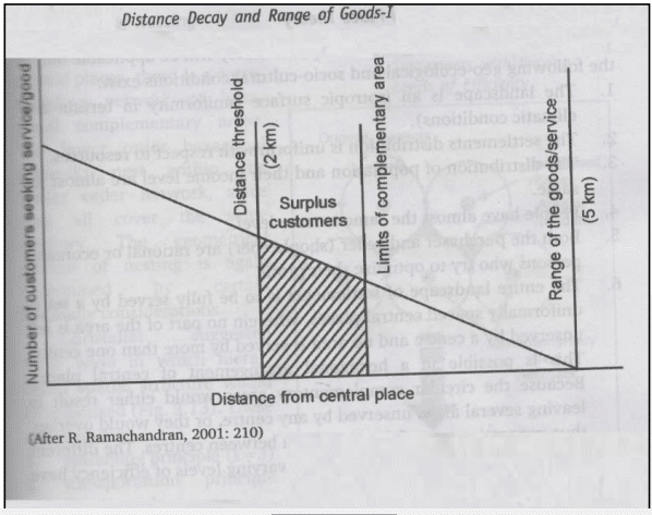
- In an isotropic surface, the distance decay function of every Goods & Services operates proportionally in all directions.
- Distance Decay function states that the interaction between two locales declines as the distance between them increases and it is applicable for higher order functions.
- In an isotropic surface, the complementary area is always a circle with the central place at the centre of this circle (i.e. there is uniformity).
5. Concept of ‘Threshold Population‘
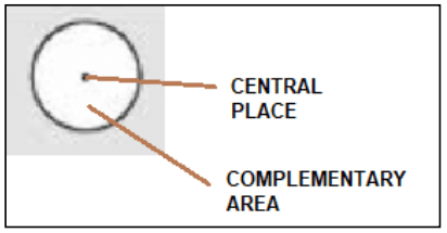
- The threshold population is the minimum number of people needed for a central place business or economic activity to remain active and flourishing. It is the lower limit — below this population, a good or service cannot be profitably offered. A grocery store or primary school has a low threshold population and can thrive on the demand of three or four villages. A designer jeweller’s shop or a specialist cardiac centre requires a much higher threshold population — typically found only in a large city.
- Lower-order goods (food, groceries, daily necessities) have low thresholds — people buy them frequently and from the nearest place available.
- Higher-order goods (automobiles, specialist medical care, university education, luxury retail) have high thresholds — people buy them less frequently, but in larger quantities and therefore from a place that can justify the scale of provision.
- This is why higher-order goods and services are concentrated in big cities — only large urban populations provide the threshold needed for their commercial viability.
- As a consequence: the number of grocery stores always outnumbers jewellery stores in any area — an empirically observable outcome of the threshold principle.
6. Concept of ‘Range of Goods & Services‘
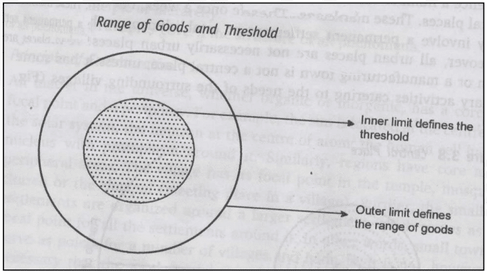
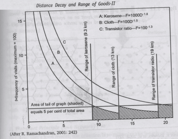
- The range is the maximum distance a person is willing to travel to obtain a particular good or service. It sets the outer boundary of the market area for that good. Beyond this distance, the consumer prefers to go to a different central place or to forgo the good altogether.
- The range is the outer boundary; the threshold defines the inner minimum. The viable market area of any good or service lies between the threshold and the range.
- The range depends on: physical distance, transport cost, passenger travel time, insurance, storage, loss of weight during transport, and discomfort in travel — together these constitute the economic distance of the good.
- A tea shop or weekly market has a small range — people won’t travel far for daily goods.
- Specialized medical services or university education have very large ranges — people travel hundreds of kilometres for access.
- Therefore, the range of a good is directly proportional to its order — higher-order goods have larger ranges, creating larger market areas and larger complementary regions around their central places.
Implications of the Concepts in Resolution of Settlement Complex under Normative Conditions
- The Complementary Area should have a threshold population to make the central place viable.
- The Range (i.e. the distance a consumer is willing to travel) should be equal to or more than the radius of the Complementary Area, because if the range is less than the radius, the consumer may not be willing to travel from the periphery of the complementary area to avail the services at a central place
- For ideal resolution, the Range should be exactly equal to the radius of the Complementary Area & the Complementary Area should have a population exactly equal to the threshold.
- For the perfect competition, neither the buyer nor seller must be at any extra disadvantage, but both are economic man & both want to maximise their profits under the least cost consideration
- A buyer will reduce his costs by minimizing transportation costs. This he can do if there are the maximum number of central places to facilitate accessibility
- A seller will maximize his costs by reducing & minimizing the central places from where he operates
- The CPT is about how the number of Central Places can best arrive where neither the seller nor the buyer is at any extra advantage or disadvantage (A trade-off in the number of Central Places & in the level of hierarchies of Central Places).
- The above resolution is possible by
- The Complementary Area must have exactly the threshold level of population
- The Range must be equal to the radius of the Complementary Area
- A higher-order central place in the hierarchy must offer all the lower order functions too along with the highest order function relevant to its hierarchical level (e.g. Delhi provides higher-order functions like parliamentary and judicial functions and lower order functions like Railways )
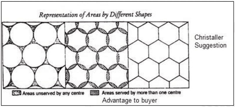
- Circular Complementary Areas are perfect (because of the maximum area within the minimum circumference) but in circular shapes, some of the buyers will be excluded if the complementary areas all made to touch tangentially
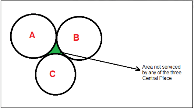
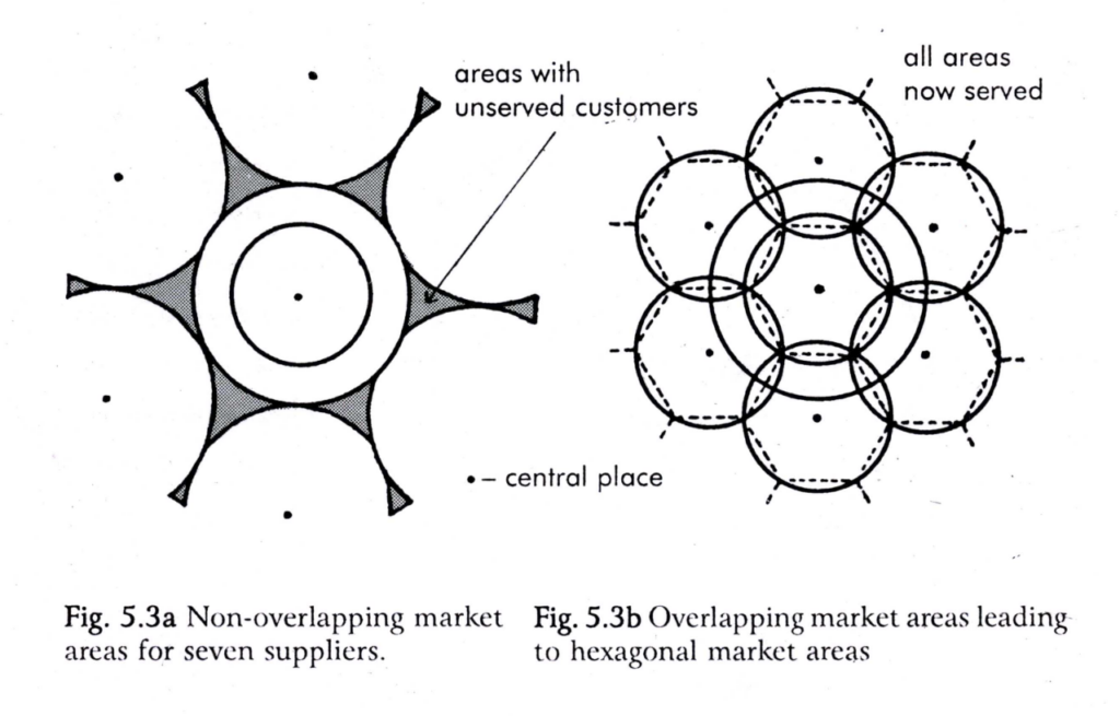
- If we want full coverage, the Complementary Areas must be made to overlap which then leads to duplication of services provided in some areas
- Christaller suggested that the next best shape in resolving the crisis is the hexagonal lattice network where the hexagonal complementary areas touch but don’t overlap and provide maximum coverage of the area.
- Hexagonal lattice do not provide advantage or disadvantage to any buyer or seller
- Settlements that are higher in the hierarchy are lower in number & are far apart (e.g. Metros such as Delhi, Mumbai, Chennai, Kolkata, etc)
- Settlements that are lower in the hierarchy are more in number & are close (e.g. Towns, Villages, etc)
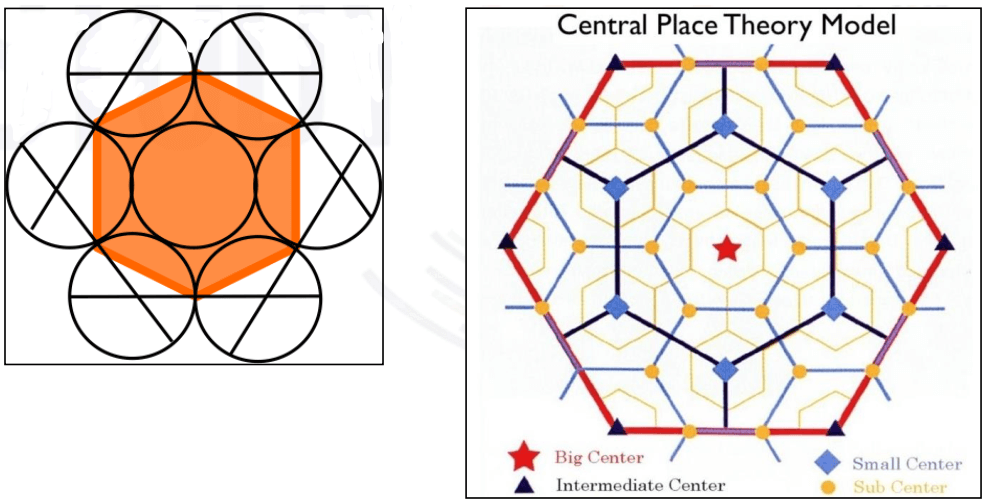
The Three K-Principles — Three Models of Spatial Organization
- To explain the spacing of urban settlements over the landscape, Christaller developed three two-dimensional models of economic landscape, each based on a different organising principle.
- Each produces a different hexagonal arrangement and a different value of K, a constant denoting the ratio of increase in the number of settlements served by each higher order.
- Each hexagon has one central place at the middle and six at the periphery, totalling 7 in a hexagon.
- In the Hexagon,
- Big Centre i.e. Metro is 1
- Intermediate Centre i.e. Cities are 6
- Small Centre i.e. Towns are numerous, and
- Sub-centre, i.e. Villages are still more
- In the Hexagon,
- Hexagons of lower orders are nested within hexagons of higher orders which is known as the Nested Pattern of Hierarchy
- Christaller identified fixed relation between 2 connecting levels of hierarchy (e.g. Towns and Cities) i.e. K value
- K indicates the number of Complementary Areas of lower-order centre served by the next higher-order centre (including itself).
- K is the ratio (except 2nd Order) in which the lower-order centers are served by the highest order central place.
- He put forward 3 types of Urban Structure pattern where
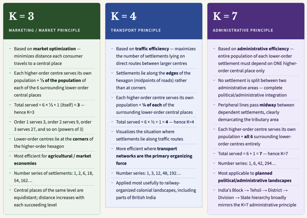
- K = 3
- K = 4
- K = 7
- K=3
- In those areas where buying and selling is most important, the Urban structure would emerge in such a way that K=3 hierarchy will develop
- K=4
- In those areas where transport cost improves, the Urban structure would emerge in such a way that K=4 hierarchy will develop
- K=7
- In those areas where the administration is centralized, the Urban structure would emerge in such a way that K=7 hierarchy will develop
Relationship Between K-Principles
The different K-values can be applied to the same region simultaneously — this affects only the size of complementary areas, not the functional hierarchy itself. In a given region, market functions may organize around K=3, transport functions around K=4, and administrative functions around K=7 — producing different, overlapping spatial patterns for different categories of services. This insight is particularly relevant for India, where multiple organizing logics operate simultaneously across its diverse regions.
Patterns of Hierarchy
- Based on the concepts of Central Place, Christaller tried to resolve the settlement complex & suggested the possible location for central places for 3 types of function
- Marketing Function
- Transportation Function
- Administrative Function
- One of the lacunae of the CPT Model is that the manufacturing function is ignored which, however, was corrected by August Losch.
- For every pattern of Central Place location, Christaller suggested 7 Hierarchical Levels as efficient hierarchical organizations.
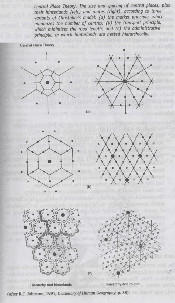
Marketing Principle (K=3)
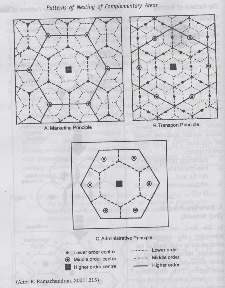
- The lower-order central places are located at the vertices of the hexagonal complementary areas of the next higher-order central place.
- Lower order settlement should be located as close as possible to higher-order settlement as to minimize the distance traveled
- In such areas, the pattern of Urban Structure will be as shown
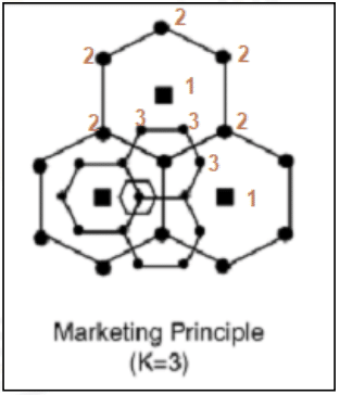
- In the given figure, 1 is a higher-order settlement and 2 is lower-order settlement whereas 2 is a higher-order settlement for 3 which is a lower order settlement
- This structure would reduce distance travelled
- Here, 6 lower-order settlements will be located around a higher order settlement (Total 7 hierarchical levels) such as 2 around 1, 3 around 2, and so on
- If ‘A’ is the area of the complementary area of higher-order and ‘a’ is the complementary area of the next lower level Central Place, then
A = (6 x (1/3)a) + a
A = 2a + a, i.e. high order settlement serving the population of 2 lower order and its own
A = 3a
A/a = 3 = K

- This implies that every higher-order center supports 3 next lower order centers
- Thus,
- Highest order centre = 1
- Next Lower Order center = 3
- Next lower-order = 9
- Next lower-order = 27 & so on till VII
- In K=3, the number of Central Places is minimized to benefit both the service providers & buyers
Transportation Principle (K=4)
- According to Christaller, for transportation resolution of space, the lower order centers must be located at the midpoint of the sides of the higher-order complimentary area.
- The criteria is to minimize the length of roads to join all adjacent pairs of central places
- Here, the lower-order center is not on the apex but on midpoints of sides to ensure the maximum number of settlements lie on a straight line route.
- Thus, each settlement is on the boundary of two rather than three hexagons
- A = (6 x (1/2)a) + a
A = 3a + a
A = 4a
A/a = 4 = K
- A = (6 x (1/2)a) + a
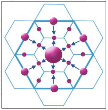
- K=4 implies that a higher-order center can support 4 next lower level centres
- In K=4 principle, the length of the road is such that it connects the maximum number of Central Places
- Route that connects higher order centre also have lower order centre on them to minimize the transportation cost
- Each lower-order centre is equidistant from only 2 higher-order centre, so the population gets divided into half
- Each higher-order centre is surrounded by 6 lower-order centre
- Thus, a higher-order centre is serving the complimentary area of 3 lower-order centre and its own area
- i.e. A = 3a + a = 4a
Administrative Principle (K=7)
- It develops in areas of highly centralised administration
- For efficient administration, there must be no duplication of decision making and that’s possible when the lower order complementary areas are nested entirely within the higher order complementary areas
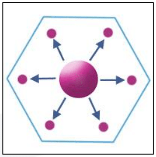
- Here, the higher order settlement serves complementary areas of all 6 lower order settlement
- Thus, shared element is eliminated
- This K=7 i.e. 6+1 , which implies that each higher order centre supports 7 next lower level centres or higher order centre supports entire complementary area of 6 lower order and its own area
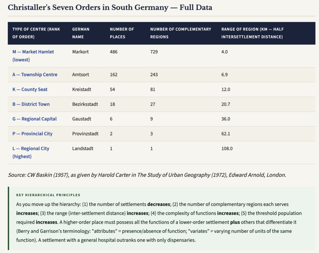
The Hierarchy of Central Places
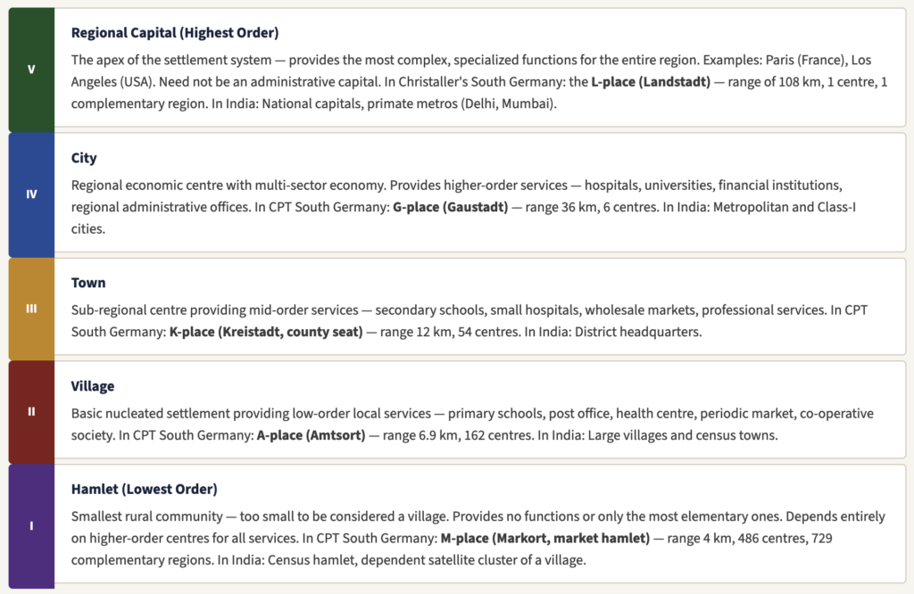
- Within the Central Place System, Christaller recognized five sizes of settlements arranged in hierarchical order.
- A higher-order central place must possess all the functions of a lower-order one plus additional, more specialized functions that differentiate it:
Evaluation
Positives
- One of the Locational Triads
- Basis of many models in Human Geography
- Innovative concepts of Normative assumptions
- The models have been used for urban planning and the hexagonal lattice network is the principle in which cell phone operators divide the mobile communication areas
- It provides the rationale for efficient division of space & function
- It was first-time such theory was put forward
- CPT has been used as an integral part of planning in countries like Germany where reclaimed land from sea used CPT for relocating settlements
- It helps us in identifying the role of settlement as a place of trade exchange & extent to which this has influenced the nature of emerging settlement pattern in any region
- It tries to seek some order in spacing & interrelationship of settlements i.e. Settlements not `arbitrarily located but there is logic & rationality behind their location
Applicability to India
- Christaller suggested 7 levels of hierarchy but for administration in India, there are 6 levels
- National Capital
- State Capital
- District Headquarter
- Tehsil Town
- Block Level
- Gram Panchayat which may itself include one or more revenue villages
- This is closest to Christaller’s perfection
- For administrative purposes, K=7, but India has 28 states and 8 Union Territories, i.e. 36 entities
- Every state has, on average, 15-20 districts
- There are more than 6 lakh villages, so in the case of India, Applicability is quite difficult.
- In India, while determining the capital of Telangana, CPT was used.
Limits
- A normative theory based on simplifying assumptions will never depict reality. It gives a false sense of objectivity and is not practically applicable as it is in the real sense.
- An Isotropic Surface is rarely found in real world
- Behaviour of consumer & seller not always rational
- Man not always an optimizer rather he is a satisfier
- The hexagonal pattern of the central place is rarely found (Region up to which goods & services provided by central place)
- The theory is suitable primarily for agricultural regions because modern factors such as communication, transport, etc have reduced the distance between buyer and seller. Rather, the world has been reduced to the level of a village
- It ignores manufacturing which is one of the most Central Place functions
- The fixed value of K gives a poor approximation of reality and
- K=3, Buying and selling important
- K=4, Transport
- K=7, Administrative,
- All take place together in real-world in Urban areas
Loschien Landscape/Modification
- Christaller’s model has been modified by an economist & geographer with a view to render this model practical & applicable to the real world.
- It was given by August Losch through the study of Iowa State in 1940.
- His model has an empirical inductive approach and provides a moderate critic (since he accepts many parts of Christaller).
- It was also the first attempt to develop a general theory of location with a major emphasis on demand
- Assumptions:
- He simplified the world to a flat uniform plain and held supply constant and assumed that demand for produce decrease with an increase in price. If a Price increase was the result of an increase in transportation cost, then demand of the product would decrease with distance from a production center. Losch treated each function as having a separate range, threshold, and hexagonal hinterland.
- Based on the Urban places of entire Germany in which he took consideration of 150 Goods & Services
- He sought to explain the size and shape of market areas within which a location would command the largest revenue
- The basis of concepts of Losch was much similar to those of Christaller original theory i.e.
- Based on Normative assumptions
- Isotropic surface, rational & economic man
- The basic concept of threshold, range, complementary were the same
- The hexagonal lattice pattern was also used by Losch as the best approximation towards the circle
- However, he raised objections to
- The variability of ‘K’ which denotes the centrality
- He has allowed ‘K’ to vary freely which means that it is different for various goods & services
- Losch considered 150 Goods & services and was antithetical to the overgeneralization of Goods & Services into 3 principles
- He prepared 150 Hexagons for the selected Goods & Services and superimposed them with higher-order at the base and lowest order at the top and rotated all the hexagons until the rich and poor sectors have emerged – such sectors were demarcated on the basis of the cost of commodity or services.
- Thus, Losch suggested a nesting pattern for 150 functions & therefore, a much extensive, continuous values of K & not just 3 values (3,4,7)
- Although the surface is isotropic, Losch suggested that the distribution of Central Place is not really uniform.
- Central Place & Service providers agglomerate to benefit from economies of Scale (i.e. when the scale of service becomes bigger, costs are shared) such as Common labour market, common customer base, and sometimes common infrastructure & raw material needs
- Therefore, there is a tendency where certain regions specialize in some types of function and services such that type of services & goods may not be available in other parts of the settlement complex.
- He found that Central place as the primate city (main dominant city) located in the center of a circle & the circle was divided into alternate bands of 12 sectors – 6 city rich sectors and 6 city poor sectors implying that city rich regions have an agglomeration of certain function and city poor will have relatively less of these function.
- Transportation lines radiate from the center & many hierarchies of settlements interwoven together (For eg- Delhi Metro).
- The landscape so produced has a densely populated & congested settlement pattern with greater randomness & spatial organization of Christaller is absent.
- This model is more applicable to the underdeveloped & developing landscape and 3rd world countries.
- His model is based on demand & production of various Goods & Services which are concentrated in Metropolis.
Merits
- Removes limiting constraints from Christaller’s model allowing more variation in threshold sphere of influence & K values (providing practical applicability in today’s scenario).
- Does not assume that settlement is based only on 3 aspects of Marketing, Transport & Administration functions but by Combination of many (150 Goods & Services & developed over 40 networks)
- Maximum purchases would be made locally.
Criticism
- Overemphasis on demand
- Abstract Nature and failure to take into consideration the problems arising from the locational interdependence of manufacturing industries & plants
- Complicated & difficult to understand but it is more close to reality
- Overlapping of networks creates the problem of cartographic representation and are difficult to understand
- CPT – applicable to those countries with sparse populations and Losch – with dense populations.
Christaller vs Lösch — Comprehensive Comparison
| Christaller (1933) | Lösch (1954) |
|---|---|
| CPT is applicable where the landscape is fully developed i.e. all settlement patterns, hierarchical levels, ordering, spacing, etc are at the fullest level of development | Applicable where the landscape is not fully developed rather it is in a stage of development and spatial organization based on the geometrical pattern is absent |
| It is applicable in developed countries | It is applicable in developing countries |
| It is closer to Rank Size rule | It is closer to the Primate City concept |
| It is based on supply factor and every Central place provides services to the Complimentary Area | It is based on demand and Central place is a production center, not merely a provider of service |
| It is based on services sector based economy | It is based on a manufacturing-based economy |
| It is an idealistic and normative model | It is more practical and applicable |
| It cannot show the regional disparity of development | It shows regional economic differences by dividing the landscape in rich and poor. |
| It has a fixed hierarchy and at each hierarchical level, the number of settlements is also fixed e.g. 1,6,36,216, etc. | It doesn’t show the fixed number of hierarchies. It has more randomness and the different hierarchical settlements are mixed and interwoven |
| ‘K’ value fixed to vary e.g. Marketing Principle = 1,3,9,etc ; Traffic Principle = 1,4,16,etc; Administrative Principle= 1,7,49, etc. | ‘K’ value is free to vary |
| All Goods & Services have been accommodated in 3 principles | Total number of Goods & Services = 150 |
| Lesser empirical validity | Much higher empirical validity |
| Sociological Approach | Economist Approach |
| Christaller’s Model is based on top to bottom analysis and the flow is from higher hierarchy to lower hierarchy. | But, in Losch, flow is from lower to higher, and the emergence of primate city or central place is due to the polarisation of economic activities |
| CPT signifies Centrifugal forces | Losch signifies Centripetal forces |
| CPT is based on South West Germany | Losch is based on the State of Iowa, USA |
Critical Evaluation of Christaller
- The normative models can’t have a universal application (based on assumptions & doesn’t include dynamism & subjectivity) but they are used as parameters to measure the reality and deviations from it
- Such models are measured on 2 principles
- Principle of Desirability – whether such models are desirable or not
- Principle of Universal Applicability – How far applicable
- Such models are highly desirable since they provide scientific temperament and structure to the subject matter
- These models are Stochastic laws (half-true), which reveal the reality and the unreal at the same time
- Their basic principles/tenets are unquestionable
- However, universal validity must not be sought as they are based on idealistic and normative principles
- In the critical evaluation, the modifications introduced by Losch reflect the major discrepancies of Christaller e.g. the fixed variability of ‘K’, supply-based model instead of demand-based, complex nesting pattern, space geometry, gross generalization of Goods & Services into 3 principles
Application
- Too idealistic to be found in real-world but has applicability in developed countries, where Rank Size Rule is found
- Countries with the larger geographical area, higher economic development, the service-based economy can have a resemblance of this model e.g. USA, Germany, France, etc
- In India, the marketing principle is applicable at the district level hierarchy. The tehsil towns have 1/3rd of their population moving into the district town for higher-order Goods & Services.
- For the administrative principle, It has the same number of hierarchy as envisaged by the CPT
- In India
| National Capital | 1 | 1 |
| State Capital | 28 | 6 |
| District Commissionary | 300 | 36 |
| District Headquarters | 600 | 216 |
| Tehsil Headquarters | 2400 | 1296 |
| Blocks | 7000 | 7776 |
| Village Panchayats | 2.75 Lakh | 46656 |
| Actual | CPT |
- Thus, it is applicable at Block Level, where the number of sellers are similar as in CPT
- Practical Aspect
- According to Qazi Ahmed, CPT is not applicable in India because it is in the developing stage
- The physiographic and climatic diversity do not allow this model to be practically applicable
- R. L. Singh has concluded that CPT has partial applicability from District to Panchayat level i.e. in the lower hierarchy.
- In a higher hierarchy, it is not applicable due to geographical area, which comes with metropolitan polarisation, or representative of their regional primacy
- R. P. Mishra stated that CPT can be applied if the landscape is fully developed, both in terms of economy and demography
- India being in the stage of development is far away from the application of this model
- The Loschien modification is, however, more applicable, at least in the few quadrants of India.
- According to Qazi Ahmed, CPT is not applicable in India because it is in the developing stage
Criticisms of Central Place Theory
Central Place Theory has generated an enormous body of critical literature. While the basic concepts of centrality, threshold, range, and hierarchy remain valuable, the specific geometric predictions of the theory have been extensively criticised:
A. Criticisms of the Assumptions
- Isotropic plain is unrealistic: Large areas of homogeneous plains are rare. Physical barriers — mountains, rivers, coasts, deserts — modify transport routes dramatically. Transport cost cannot be the same in all directions. In mountainous regions, roads are expensive to build; rivers offer cheap transport; airways provide costly but efficient connections in remote areas.
- Perfect competition is unreal: Some farms, enterprises, and regions always earn more than others due to localization economies, agglomeration benefits, and historical advantages. Perfect competition — a required assumption — is never observed in reality.
- Government intervention disrupts the pattern: Political decisions can relocate industries, create new towns, build special economic zones, or designate capital cities in locations that make no market sense. India’s decision to make Chandigarh the capital of Punjab (instead of Lahore, which went to Pakistan) is an example of deliberate political intervention in settlement patterns.
- Population and resources are not evenly distributed: Christaller overlooked natural endowments and individual shopping behaviour. People do not always prefer the nearest shop — loyalty, habit, quality preferences, and social relationships all influence where people shop.
- Each centre does not have a single function: Christaller envisaged that each centre has a particular dominant function. In reality, one settlement may perform many functions simultaneously, and the dominant function of a settlement may change over time (e.g., a mining town becoming a service centre after mine exhaustion).
B. Criticisms of the Model’s Static Nature
- Too static: CPT was criticized for being “too static” — it describes a hypothetical equilibrium state but does not explain how the settlement system changes over time in response to economic development, technological change, or population growth.
- Suitable for agricultural areas only: The model was developed for the pre-industrial, agriculturally organized landscape of southern Germany. Its applicability to industrial cities, post-industrial service economies, and digital-age urban systems is highly limited.
- Ignores manufacturing: By focusing exclusively on tertiary service functions, CPT entirely ignores the role of manufacturing industry as an organizer of settlement patterns — a major gap in a theory claiming to explain urban systems.
- Hexagonal geometry outdated: The hexagonal geometry of the model and the concept of K-values or nesting have been found to fail empirical tests consistently. Observed settlement patterns rarely conform to hexagonal arrangements.
C. Criticisms from Humanistic Geography
- CPT is normative, not descriptive: It tells us where central places should be under ideal conditions, not where they actually are. It falls short of perfection when assessed in the light of humanistic geography, which emphasizes human agency, perception, and cultural difference.
- Consumers don’t always go to the nearest centre: A study by V. Prakash Rao and R. Ramachandran in the Muzaffarnagar district of Uttar Pradesh (1974) directly challenged this assumption. They showed that the richer sections of rural society tend to bypass their lower-order central places and invariably go to higher-order ones for goods and services. The choice of central place was significantly influenced by multipurpose visits, differences in price levels, the consumer’s socio-economic position, and the mode of transport available.
- Is market optimization universally true? The assumption that all people seek to maximize market efficiency is a Western, individualist, economic rationality concept that does not hold across all cultures. In India, caste, community affiliation, religious practices, and social relationships significantly influence where people go for goods and services.
Applicability of CPT in the Indian Context
What Works — Partial Applicability
- Administrative Hierarchy (K=7): India’s administrative system — Village/Gram Panchayat → Block → Tehsil/Taluka → District → Division → State → National — broadly reflects the administrative principle of K=7, where each lower-order unit falls entirely within one higher-order administrative jurisdiction.
- District-level Marketing Principle (K=3): At the district level in India, the pattern of tehsil towns serving surrounding villages as periodic market centres shows partial conformity to the K=3 marketing principle — particularly in agriculturally uniform plains like the Gangetic plain and parts of the Deccan Plateau.
- Functional Hierarchy of Services: The concept of threshold is clearly visible in India — primary health centres and primary schools are found in all villages, while specialist hospitals and colleges are found only in district towns and cities. This functional hierarchy of services is a direct manifestation of CPT’s threshold principle.
- Rural Hierarchy in India: Mondol (1988) presented a hierarchical ordering of Indian villages based on medical, communication, educational, and commercial facilities — which mirrors CPT’s multi-function ranking of central places. (See: Table 4.1 in Sumita Ghosh — three orders of villages distinguished by presence of: health centre/P.O./primary school/periodic market → dispensary/P.T.O./high school/permanent market → hospital/telephone/college/wholesale market.)
What Doesn’t Work — Limitations in India
- Topographic diversity: India’s landscape ranges from the Himalayan mountains to the desert, from coastal lowlands to the Deccan plateau. No isotropic plain exists across which uniform transport and settlement patterns could develop.
- Colonial distortion: British colonial infrastructure investment was not guided by market optimization but by administrative control and resource extraction. Railway lines were built to connect ports to hinterlands for export, not to connect villages to their nearest market towns. This has created a legacy of transport networks that severely distort CPT’s expected patterns.
- Prof. N.R. Kar’s finding on Calcutta (1960): Prof. Kar concluded: “In respect of areal distribution of central places one can faintly discern a pattern, if at all, around the city of Calcutta. But they do not exactly conform to any established law of geometrical patterns as found in South Germany. Certain factors operating at the end of the 17th century, such as historical events, initial physiographic advantages, rapid industrial growth, and the declining agriculture of the surrounding areas, explain the break in the normal grade of urban hierarchy.”
- Richer households bypass lower-order centres: V. Prakash Rao and R. Ramachandran’s Muzaffarnagar study (1974) showed that the richer sections of rural society bypass lower-order central places and go directly to higher-order ones — violating CPT’s assumption that people always use the nearest available centre.
- Caste-based spatial organization: Caste hierarchy and the Jajmani system created patterns of service provision in Indian villages that are completely orthogonal to CPT’s market logic — services were provided based on hereditary social obligation, not market demand and supply.
- Religious and pilgrimage economy: Towns like Varanasi, Tirupati, Haridwar, and Mecca function as religious central places with national or global spheres of influence that have nothing to do with CPT’s market optimization logic.
- Post-liberalization disruption: E-commerce, telemedicine, and online education are now allowing smaller towns to access services previously available only in large cities — reducing the functional differentiation between hierarchy levels that CPT depends on.
CPT in Indian Planning — Practical Applications
- The concept of growth centres and growth poles in Indian regional planning — designating certain towns as service centres for their surrounding rural areas — directly draws on CPT’s logic of central places and complementary regions.
- India’s block development offices, community development blocks, and panchayat raj institutions are organized around a central place logic: each block headquarters serves as a service centre for surrounding villages, much like Christaller’s administrative principle.
- The Smart Cities Mission implicitly uses CPT logic by identifying 100 cities as potential higher-order central places that need to provide quality services to their surrounding regions — reducing over-dependence on mega-cities.
- The RURBAN mission (Shyama Prasad Mukherji Rurban Mission) explicitly aims to develop clusters of villages with urban amenities — essentially creating new middle-level central places in India’s settlement hierarchy where none previously existed at sufficient density.
Planning Applications and Contemporary Relevance of CPT
- Retail and commercial location planning: CPT is used by retailers to decide where to locate stores — large retail chains use threshold and range analysis to identify viable locations across a regional hierarchy of settlements.
- Hospital and healthcare facility planning: Different levels of health services (dispensary, community health centre, district hospital, medical college hospital) are allocated to settlements of corresponding hierarchical levels — directly following CPT’s threshold logic.
- Educational facility planning: Primary schools at village level, secondary schools at block level, colleges at district level, universities at metropolitan level — this hierarchical allocation of educational infrastructure uses CPT as its implicit framework.
- Transport network planning: The K=4 transport principle guides the design of road and rail networks to maximize the accessibility of as many settlements as possible to higher-order centres, with lower-order settlements lying at midpoints of routes between major cities.
- Regional planning and growth centres: Planners use CPT to identify “missing” central places in a region — settlements that should exist but do not — and designate new growth centres to fill the functional gaps in the hierarchy.
- Identifying hierarchy for rural service provision: The IGNOU textbook (Unit 15, CPT.pdf) notes that CPT helps explain: (1) consumer services distribution; (2) market area analysis; (3) hierarchy of services and settlements — all directly applicable to planning rural service delivery in developing countries like India.





Couldn’t Thank enough, this got to be the best notes for the optional. Thanks a lot.
Most Welcome. keep reading
How was your exam after reading these notes…?
Download Complete Notes Here – https://store.lotusarise.com/product/upsc-geography-optional-complete-notes-pdf/
Good content,but it’s problem 150 words not simulat this writtens in exam.hall
Thanks a lot.
thanks for your view
Explain how you did the last table with the CPT and Actual values of Administrative centers in India
National Capital 1 1
State Capital 28 8….
It will be 28 and 6, I have corrected the same. Keep reading.
Thank you for responding.
I have never came across a calculation in Central plave theory like this.
Usually we see √3 multiples for distance calculations
And multiples of 3 for no of population.
First time encountering multiples of 6, any reason?
Again Thank you
Hierarchical level 1,6,36,216, etc.
/ Good
Application table is wrong how 6 and it’s multiple instead of 7
Good explanation… Thanks a lot.
One of the mesmerizing notes of this headache topic….🙏🙏
Download Complete Notes Here – https://store.lotusarise.com/product/upsc-geography-optional-complete-notes-pdf/
In a point.. applicability to India…plz confirm …in a given example..is it Telangana or Andrapradesh..
Keep posting such type of beautiful content ❤️❤️ you are very helpful
Best geography optional notes ever seen
Download Complete Notes Here – https://store.lotusarise.com/product/upsc-geography-optional-complete-notes-pdf/