

- A planning region is a territory over which development decisions are made and carried out as one unit. It is defined by the planning purpose, not by nature alone.
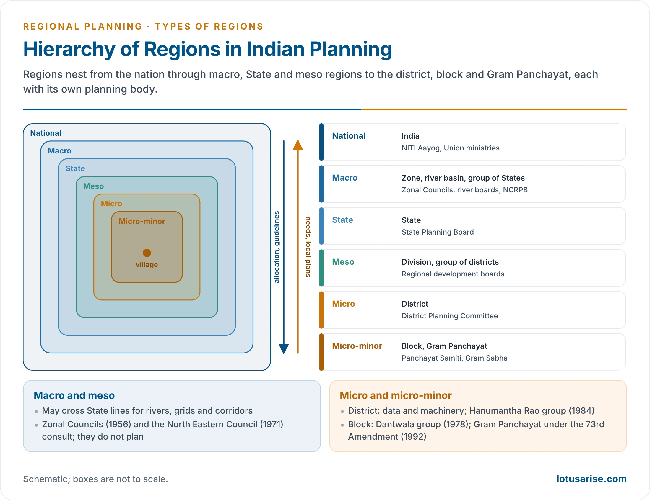
- Planning works through a hierarchy of regions: the nation, macro regions of several States, the State, meso regions of several districts, and micro regions at the district, block and village level.
- India has tried several schemes of planning regions, from the resource regions of the 1960s to the agro-climatic regions of 1989, and uses special regions such as river basins and the National Capital Region.
- In practice most plans are still made for administrative units, because data and machinery exist only there. The gap between the ideal region and the administrative one is the central problem of regional planning in India.
Concept of a Planning Region

Meaning and Definitions
- A planning region is a segment of territory over which economic decisions apply and through which national objectives are turned into regional programmes.
- The whole country is the planning region for the national plan, the State for the State plan, and the district or block for micro-level plans.
- Jacques Boudeville (1966) called it an area displaying coherence or unity of economic decision, under one planning authority. It is the third of his regions, after the homogeneous and the polarised region.
- Leo H. Klaassen (1965) set out the tests: a planning region must be large enough to take investment decisions of an economic size, supply its own industry with labour, have a broadly homogeneous economic structure, contain at least one growth point, and share an awareness of its problems.
- R. P. Misra, K. V. Sundaram and V. L. S. Prakasa Rao (1974) saw it as a synthetic region. It fuses four other kinds of region:
- economic regions, delimited by resource potential;
- social regions, such as tribal or low-income regions;
- environmental regions, marked by destruction, by a need for preservation, or by special problems;
- administrative regions, which already carry the machinery of planning.
- This echoes Patrick Geddes’s triad of Place, Work and Folk (environment, economy and society), which a regional plan must treat as one interacting system.
- A planning region is therefore usually a compromise between a formal (homogeneous) and a functional (nodal) region that is also administratively viable. These types of regions are combined, not chosen between.
- Because development changes the economy, a planning region is dynamic and operational. Its boundaries need to be fixed for administration but revised over time.
Criteria for Delimiting a Planning Region
- The criteria used for India’s macro and meso regions by the Town and Country Planning Organisation (TCPO) remain the standard list:
- Size: large enough to hold the range of resources needed for economic viability, but not so large that a comprehensive approach becomes too general.
- Resource diversity: varied resources that allow a production pattern for both consumption and exchange.
- Nodality: an organisation of nodal points, existing or developable, to serve the whole region.
- Common problems: an area where an area-wide approach to resource problems is feasible and desirable.
- Common potential: similar prospects of future development.
- Contiguity and internal cohesion: cohesion from homogeneity of resources or from complementarity and flows.
- Social unity: enough shared identity for people to recognise their problems and accept responsibility for them.
- Respect for administrative units: regions built by grouping the smallest administrative units, which carry data and communication.
- Flexibility: an operational region that can be adjusted as development proceeds.
- Two further tests are often added:
- narrow internal disparity, since very unequal parts are hard to plan as one unit;
- data availability, since a region without statistics cannot be planned.
- The methods used to delimit such regions are those of regionalisation: composite indices for formal regions and flow analysis for functional ones.
Economic and Environmental Factors
- Economic factors decide whether a region can sustain its own development:
- a viable resource base of land, minerals, water and power;
- production specialisation, so that each region produces what it is best suited for (the Soviet idea of territorial production complexes);
- complementarity, pairing surplus and deficit areas;
- a nodal centre and transport links that organise flows of goods, labour and capital;
- self-sufficiency in food and employment at the macro level, as a balance of exchange rather than a closed economy.
- Environmental factors decide whether that development can last:
- ecological balance: a macro region should contain hills and plains, forests and farmland, so that natural cycles are complete;
- hydrological units, the river basin and the watershed, for water, flood and soil planning;
- agro-climatic homogeneity for agricultural planning;
- fragile and hazard-prone zones, such as the Himalaya, the Western Ghats, deserts, coasts and flood plains, which need separate treatment;
- carrying capacity, which limits how far a region can be developed. These environmental issues in regional planning are weighed at every level.
- India’s experience shows both at work. The Damodar Valley combined a river basin with a coal–steel–power complex; the drought-prone and desert programmes were drawn on environmental lines; industrial corridors are drawn on economic ones.
Natural Regions and Planning Regions
- A natural region is an area of broadly uniform physical conditions: relief, structure, climate, soils and vegetation. It is a formal, descriptive region.
- India’s schemes run from Dudley Stamp’s three macro and 22 sub-regions (1922) to O. H. K. Spate’s regions of several orders (1954).
- A planning region is a purposive, prescriptive region, defined for action. It may contain several natural regions, and often should.
| Basis | Natural region | Planning region |
|---|---|---|
| Purpose | Describe the physical environment | Organise development |
| Criteria | Relief, climate, soil, vegetation | Resources, flows, nodality, administration, problems |
| Character | Homogeneous, formal | Mixed formal and functional |
| Boundaries | Physical; ignore administration | Usually follow districts, blocks or States |
| Change | Stable over long periods | Dynamic; revised with development |
| Ideal content | Uniformity | Unity within diversity, for complementarity and ecological balance |
| Examples | Malwa Plateau, Chota Nagpur, Thar | NCR, DVC area, Bundelkhand, KBK, agro-climatic regions |
- Natural regions remain the foundation: planners map them first, then group or split them by economic and administrative criteria. As Dudley Stamp put it, the naturalness of natural regions is fading as heterogeneous planning regions take their place.
Hierarchy of Planning Regions
- A Planning Commission conference on regional survey and planning (Delhi, October 1956) agreed that India needed planning regions at three levels: macro, meso and micro.
- Misra and his colleagues listed seven territorial systems: the nation, inter-state macro regions, the State, inter-district meso regions, the district or metropolitan region, the block, taluk or city region, and the village.
- Inter-state and inter-district regions mostly have no formal boundaries or machinery. This is why they remain weak in practice.
Macro Regions
- A macro region is larger than a State or a group of States, or parts of several States.
- It handles problems that need inter-related, large-scale solutions: river basins and irrigation systems, power supply, food self-sufficiency, industries of national importance and trunk transport.
- It should contain a complete matrix of resources, at least one industrial nucleus with a strong power base, and an apex centre linked to a hierarchy of towns.
- It is expected to be heterogeneous: complementarity and ecological balance are possible only at this scale.
- Examples:
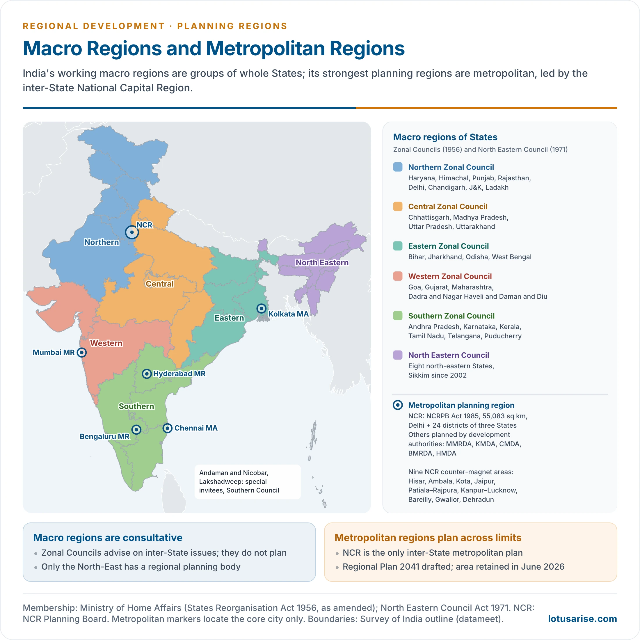
- the five Zonal Councils (States Reorganisation Act, 1956), which are consultative bodies for groups of States;
- the North Eastern Council (1971; Sikkim added in 2002), the one macro region with its own planning body;
- large river basins such as the Ganga or the Godavari;
- the eastern region, for which the Union Budget 2024–25 announced a Purvodaya plan covering Bihar, Jharkhand, West Bengal, Odisha and Andhra Pradesh.
Meso Regions
- A meso region is a sub-State unit of several districts with a recognisable identity: physical, historical or economic.
- Its aim is a viable unit for exploiting, conserving and using resources, able to meet its people’s employment and minimum food needs over time.
- Meso regions may join complementary tracts. The TCPO scheme paired the Kerala coast with its plantation hills, and the dry Telangana plateau with the Krishna–Godavari delta.
- Indian examples: Vidarbha, Marathwada, Saurashtra, Kutch, Bundelkhand, Rayalaseema, North Bengal, the Kalyana-Karnataka (Hyderabad-Karnataka) region.
- Some have statutory development boards: Vidarbha, Marathwada and the rest of Maharashtra under Article 371(2) (boards from 1994), and Kalyana-Karnataka under Article 371J (2012).
Micro Regions
- The micro region is the lowest planning unit, close enough to the people for direct participation.
- It has a core problem or interest and includes all territory tributary to it. It can be of three kinds:
- nodal regions: a town and its minimum influence area, or a metropolitan area;
- rural service areas around potential growth points;
- problem areas: a coal belt, a famine-prone tract, the Chambal ravines, the Terai, Rayalaseema.
- The district is India’s working micro region, because data and compact administration exist there. Below it the block and the village cluster serve multi-level planning and grassroots plans.
- Micro regions are also drawn on natural lines: the watershed, the irrigation command area, the agro-climatic sub-zone.
| Level | Typical unit | Planning body | Main concern | Example |
|---|---|---|---|---|
| National | India | NITI Aayog (Planning Commission until 2014) | Growth, inter-State allocation | National plans and strategies |
| Macro | Group of States, large basin | Zonal Councils, North Eastern Council | Power, water, trunk transport, heavy industry | North-East, Ganga basin |
| State | State or UT | State planning board | State plan, sectoral priorities | Any State |
| Meso | Group of districts | Regional development boards | Resource use, regional balance | Vidarbha, Bundelkhand |
| Micro | District, metropolitan area | District and metropolitan planning committees | Integrated area plan | Mumbai Metropolitan Region, a district plan |
| Micro-minor | Block, village cluster, watershed | Block and Gram Panchayat | Basic needs, local resources | Gram Panchayat Development Plan |
Schemes of Planning Regions in India
Prakasa Rao and Bhat: Resource Development Regions
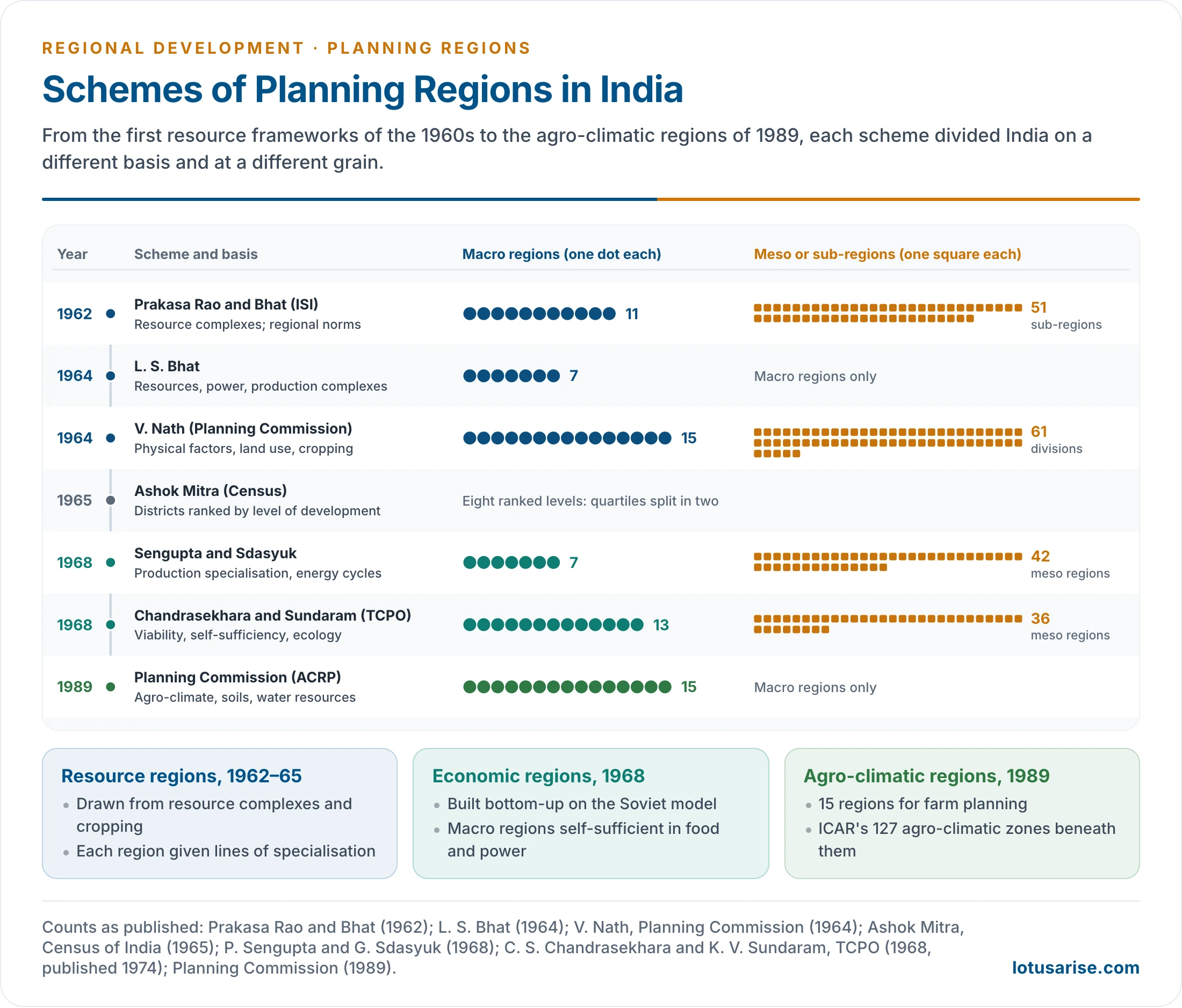
- The Regional Survey Unit of the Indian Statistical Institute prepared a tentative regional framework for resource development (1962), associated with V. L. S. Prakasa Rao and L. S. Bhat.
- It identified 11 major regions and 51 sub-regions.
- It was built from qualitative maps of physical complexes, cropping patterns, natural resources, major industries and urban centres.
- The guiding rule was minimum disparity within a region and maximum distinctiveness from its neighbours.
- Each region was given regional norms of development: the lines of production for which it had the greatest potential.
- L. S. Bhat (1964) then proposed seven macro-economic regions.
- They were made of parts of adjoining States, on the basis of resources, including power, and the possibility of regional production complexes.
- As a practical alternative, he grouped whole States into five macro regions, since data were available only by State.
V. Nath: Resource Development Regions and Divisions
- V. Nath prepared a scheme published by the Planning Commission in 1964: 15 regions and 61 divisions.
- It used topography, geology, soils, rainfall, land use, cropping pattern, population density and minerals.
- The regions cut across State boundaries, but the divisions were kept inside States so that States could relate their programmes to them.
- Critics saw this “concession to administrative reality” as defeating the purpose of regional planning, which is to overcome arbitrary boundaries.
Ashok Mitra: Levels of Regional Development
- Ashok Mitra, Registrar General for the 1961 Census, ranked India’s districts by levels of development (1965).
- He grouped indicators into blocks: general ecology, agricultural infrastructure, participation in traditional sectors, human resources, trade and infrastructure, and modern organised industry.
- Districts were ranked, divided into quartiles, and each quartile split again, giving eight levels.
- He preferred a ranking to a fixed hierarchy because it could change as districts developed. The scheme was strong on social data but weak on physical features.
Sengupta and Sdasyuk: Economic Regions
- P. Sengupta and the Soviet geographer Galina Sdasyuk published Economic Regionalisation of India: Problems and Approaches (Census of India monograph, 1968).
- They applied the Soviet concept of economic regions and production specialisation, drawing on N. N. Kolosovsky’s energy-production cycles (territorial production complexes).
- The method ran from the bottom up:
- micro regions coincide with single or multiple resource areas and with tehsil or police-station boundaries;
- meso regions are multipurpose units with production specialisation of national, regional and local importance;
- macro regions can run production cycles of national importance and are self-sufficient in food. They are formed by grouping meso regions and, as far as possible, follow State boundaries.
- Result: 7 macro regions and 42 meso regions.
- The macro regions were the North-Eastern, Eastern, North-Central, Central, North-Western, Western and Southern regions.
- They also classed regions by stage: dynamic (the West Bengal delta), prospective (the north-eastern Peninsula) and problem regions (the overcrowded middle Ganga plain).
TCPO Scheme: Chandrasekhara and Sundaram
- C. S. Chandrasekhara and K. V. Sundaram of the Town and Country Planning Organisation drew up a two-tier scheme (1968), published in full by Misra and his colleagues in 1974.
- Its principles were economic viability, self-sufficiency and ecological balance. It sought to link resource-rich areas with complementary or resource-poor ones so that growth would flow between them.
- Result: 13 macro regions subdivided into 36 meso regions, both cutting across State boundaries. Metropolitan regions were marked separately.
- The macro regions were the South Peninsular, Central Peninsular, Western Peninsular, Central Deccan, Eastern Peninsular, Gujarat, Western Rajasthan, Aravalli, Jammu–Kashmir–Ladakh, Trans-Indo-Gangetic Plains and Hills, Ganga–Yamuna Plains, Lower Ganga Plains and North-Eastern regions.
- Madhya Pradesh, with its diverse terrain, was split among four macro regions.
Agro-Climatic Regions (1989)
- The Planning Commission’s Agro-Climatic Regional Planning project (begun 1988) divided India into 15 agro-climatic regions in 1989, with the National Remote Sensing Agency.
- The basis was soil, rainfall, temperature, water resources and physiography.
- Each region has a development profile mixing crops, animal husbandry, horticulture, forestry and agro-processing.
- The 15 regions:
- Western Himalayan, Eastern Himalayan;
- Lower, Middle, Upper and Trans-Gangetic Plains;
- Eastern, Central, Western and Southern Plateaus and Hills;
- East Coast Plains and Hills, West Coast Plains and Ghats;
- Gujarat Plains and Hills, Western Dry Region and the Island Region.
- Their aims: a demand–supply balance of major commodities, higher farm incomes, more rural employment, and sustainable use of land, water and forests.
- Finer agricultural planning regions followed:
- the 127 agro-climatic zones of ICAR’s National Agricultural Research Project;
- the 20 agro-ecological regions of the National Bureau of Soil Survey and Land Use Planning.
- Both are part of agricultural regionalisation.
| Scheme | Year | Basis | Macro | Meso or sub-regions |
|---|---|---|---|---|
| Prakasa Rao and Bhat (ISI) | 1962 | Resource complexes, regional norms | 11 | 51 |
| L. S. Bhat | 1964 | Resources, power, production complexes | 7 | — |
| V. Nath (Planning Commission) | 1964 | Physical factors, land use, cropping | 15 | 61 divisions |
| Ashok Mitra (Census) | 1965 | Levels of development of districts | Ranked levels | — |
| Sengupta and Sdasyuk | 1968 | Production specialisation, energy cycles | 7 | 42 |
| Chandrasekhara and Sundaram (TCPO) | 1968 | Viability, self-sufficiency, ecological balance | 13 | 36 |
| Planning Commission (ACRP) | 1989 | Agro-climate, soils, water | 15 | — |
Special Planning Regions in Practice
River Basin Regions
- The river basin is the natural unit for water planning. The National Water Policy asks that water be planned by basin or sub-basin.
- India has 12 major basins (over 20,000 sq km each) and 46 medium basins. The Central Water Commission groups the country into 20 basins.
- Inter-State basins cover about 81% of India’s area.
- India’s first regional planning body was a basin authority: the Damodar Valley Corporation (1948), modelled on the Tennessee Valley Authority (1933). It joined flood control, irrigation, power and soil conservation across Jharkhand and West Bengal.
- The River Boards Act, 1956 allows inter-State river boards, but none has been set up under it. Basin bodies exist only for limited purposes: the Bhakra Beas Management Board, the Narmada Control Authority, the Brahmaputra Board, the Betwa River Board.
| Advantages of river basins as planning regions | Disadvantages |
|---|---|
| Natural unity of water, soil and land use | Cut across State boundaries; inter-State disputes (Kaveri, Krishna, Mahadayi) |
| Integrated flood control, irrigation, power and navigation | Single-purpose focus on water; industry and services ignored |
| Upstream–downstream linkages planned together | Very large basins (Ganga) too big for one plan |
| Catchment treatment protects reservoirs | Data are collected by district, not by basin |
| Suits watershed and command-area planning at lower levels | Weak authorities: the DVC became mainly a power utility |
- A command area is only the irrigated part of a basin served by a canal system. Its planning, through the Command Area Development Programme, is a micro-level task within the basin.
Metropolitan and City Regions
- A metropolitan region is a city and its daily commuting and service hinterland: a functional region planned as one unit.
- The 74th Constitutional Amendment (1992) provides for a Metropolitan Planning Committee in every area of 10 lakh people or more (Article 243ZE).
- Development authorities plan the largest regions: Kolkata (KMDA, 1970), Chennai (CMDA), Mumbai (MMRDA, 1975), Bengaluru (BMRDA, 1985) and Hyderabad (HMDA, 2008).
- The National Capital Region is India’s only inter-State metropolitan planning region.
- It was created under the NCR Planning Board Act, 1985.
- It covers 55,083 sq km: all of Delhi, 14 districts of Haryana, 8 of Uttar Pradesh and 2 of Rajasthan (since 2018).
- The first Regional Plan (RP-2001) was notified in 1989 for 30,242 sq km. RP-2021 followed in 2005.
- The draft Regional Plan 2041 (2021) projects about 11 crore people by 2041. In June 2026 the Board kept the region’s area unchanged and proposed four “Namo Cities” on the Namo Bharat (RRTS) corridors, ahead of notifying the plan.
- Nine counter-magnet areas (Hisar, Ambala, Kota, Jaipur, Patiala–Rajpura, Kanpur–Lucknow, Bareilly, Gwalior and Dehradun) were meant to divert migration from Delhi.
- NITI Aayog’s Growth Hub initiative (2023) prepares economic master plans for city regions. Its pilots are the Mumbai Metropolitan Region, Surat, Varanasi and Visakhapatnam.
- The Surat Economic Region covers six districts of south Gujarat.
- Metropolitan planning fosters regional development in several ways:
- decongesting the core through satellite towns, counter-magnets and regional transit;
- spreading industry and services into the hinterland;
- integrating land use and transport across municipal and State limits;
- making the metropolis the apex of a hierarchy of growth centres, as in growth pole theory.
- The record is mixed:
- Delhi’s growth kept outpacing the NCR plan’s targets, and the counter-magnets grew slowly.
- Planning bodies overlap with municipal and State agencies.
- Peri-urban sprawl, water stress and air pollution spill across boundaries that the plan cannot enforce.
- The metropolitan region is also the subject of town planning in India and of the sphere of urban influence.
Problem and Special-Area Regions
- Depressed or problem regions are drawn for their backwardness: KBK (Kalahandi–Bolangir–Koraput) in Odisha, Bundelkhand in Uttar Pradesh and Madhya Pradesh, and the left-wing extremism districts. Their identification and programmes are part of backward area planning.
- Special-area regions are drawn by physical handicap: drought-prone, desert, hill, tribal and island regions.
- Axial or corridor regions follow a transport spine: the Delhi–Mumbai Industrial Corridor and the other industrial corridors.
- Aspirational districts and blocks (2018, 2023) treat the district and the block as micro planning regions, ranked on development indicators.
Evaluation
- Achievements:
- Indian geographers built a rich body of regionalisation schemes and methods.
- River-basin, agro-climatic, metropolitan and special-area regions have all been used in real programmes.
- The district and the block have become working planning regions.
- Limitations:
- The academic schemes were never adopted as a national framework. Plans stayed sectoral and State-based.
- Data and administration exist only by administrative unit, so regions that cross boundaries lack both information and authority.
- Inter-State regions depend on State consent. The DVC was diluted, river boards were never created, and the NCR plan cannot bind its States.
- Regions are fixed while economies change; few schemes were revised.
- Current trend:
- Planning is moving towards nested regions with clear functions: river-basin management for water, city regions for growth, districts and blocks for outcomes.
- All of them are now monitored with real-time data and geographic information systems.
Previous Year Questions
2024Assess the criteria required for selecting regions for developmental planning?2023Describe the concept of Planning Region. Explain the environmental and economic factors in the creation of such regions.2019What are natural regions? How are they different from planning regions?2013City-regions as territorial unit for regional planning and development.2001Examine the geographical basis of agro-climatic planning regions of India.1997Draw a sketch map of India showing major rivers basins. Examine the feasibility of the concept of river basins as a planning unit.1995Give the hierarchy of planning regions and bring about the role of metropolitan planning in fostering regional development in India.1988Differentiate between River Basin and Command Area. Discuss the advantages and disadvantages of River Basins as Planning regions in India. Give concrete examples.




