Regions are classified on the basis of selected criteria and purpose or goal. No single typology of regions is universally valid — the type of region that a geographer, planner, or administrator delineates depends entirely on the question being asked and the task at hand. This purposive, criteria-based nature is the central feature of regional classification.
The same territory may simultaneously be a formal region (based on its physical homogeneity), a nodal region (based on flows to a city), and a planning region (for administrative development purposes). Classification is always purpose-dependent.
Several major frameworks organise regional typology. The three most fundamental types — formal (homogeneous), functional (nodal), and vernacular (perceptual) — represent different philosophical approaches to understanding how and why areas cohere.
Beyond these, there are developmental typologies (developed, backward, intermediate), multi-level planning typologies (macro, meso, micro), and activity-based typologies (mineral, manufacturing, cultural regions).
Regions are primarily classified based on genesis:
Naïve region: It is a mental construct/ idealistic and hypothetical and subjective in nature (e.g. backward region).
Institutedregion
Denoted region or Planning region
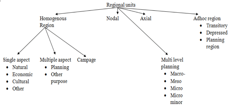
Several geographers have worked on the typology of regions. Typology approach is also known as classical approach divides the region into
Single aspect region
Multiple aspect region
Regions of totality
Functional regions
Regions can also be classified as
Regions based on the physical character
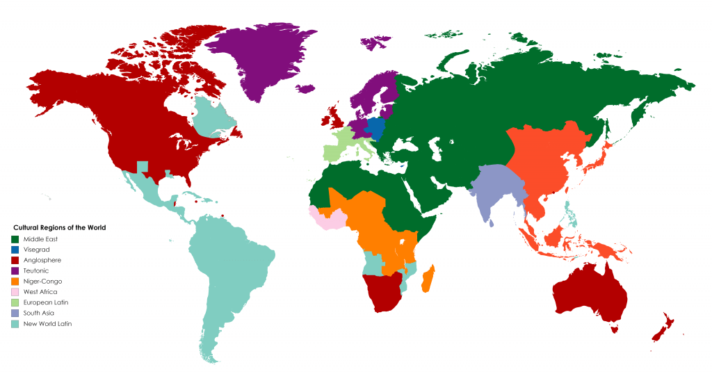
Regions based on cultural character
Regions based on an amalgamation of physical and cultural variables
Regions can also be classified on the basis of scale for Multi-Level Planning
Macro-Macro level for studying a whole nation or state
Macro-level for studying states within a nation
Meso level for studying districts
Micro-level for studying city/village
Micro minor level for studying a particular sector or household
Based on Areal homogeneity regions can be classified into
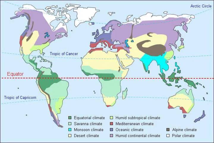
Physical region: It includes land, soil, climate, vegetation, etc. For example Tropical region, Savanna region, Black soil region, Downs, etc.
Economic region: It includes industrial regions, agricultural regions, services, etc., for example, Special Economic Zones, Great North Indian Plains.
Cultural region: the demarcation of the cultural region is based on language, religion, etc. For example Hindi heartland, tribal regions, etc
Campage Regions with more than one feature showing areal homogeneity. The above regions were demarcated based on a single feature but in Campage more than one features are selected.
Based on Areal Linkages regions can be classified into
Nodal region: Here there is one dominant urban centre around which smaller urban/rural areas develop.
Axial region: It is the region that develops along a corridor and performs a special function. E.g. DMIC along National Highway 8
Adhoc region: they are transitional regions not on a permanent basis, and are generally backward regions. Here planning is done with a specific purpose in order to develop the particular region.
Nowadays, a more comprehensive approach is followed for better planning and development.
Frameworks of Regional Classification
A. Typology / Classical Approach
Several geographers have worked on the typology of regions. The typology approach, also known as the classical approach, divides regions into single-aspect and composite types. Under this framework:
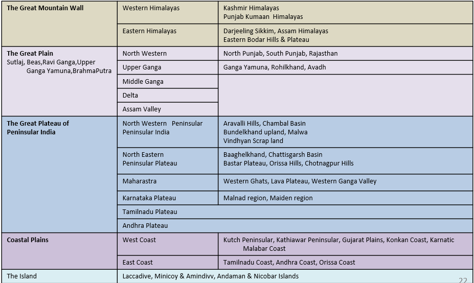
Single-aspect regions — delimited on the basis of one criterion only. E.g., physiographic regions of India (based on topography), climatic regions (based on temperature/rainfall).
Physical region — includes land, soil, climate, vegetation. E.g., Tropical region, Savanna region, Black soil region, Downs.
Economic region — includes industrial regions, agricultural regions, service regions. E.g., Special Economic Zones, Great North Indian Plains.
Cultural region — demarcation based on language, religion. E.g., Hindi belt, Central India tribal belt.
B. Regional Economics Approach (A. Boudeville)
From the perspective of regional economics, Boudeville and others classify regions into three fundamental types that are widely adopted in planning literature:
Homogeneous Regions (Formal Regions) — based on similarity of attributes
Nodal, Polarized, Heterogeneous or Functional Regions — based on functional interdependence around a centre
Planning and Programming Regions — based on administrative convenience and policy implementation
C. Denoted vs. Vernacular Regions
A crucial distinction in regional geography is between denoted regions (created by scholars through deliberate analysis) and vernacular/perceived regions (arising from people’s collective cultural identity). This distinction maps onto the objective-subjective divide in regional geography.
Criterion
Denoted Region
Vernacular Region
Origin
Created by scholars/planners through regionalization
Emerges from collective cultural identity of inhabitants
Boundaries
Precisely delimited (or attempted)
Ill-defined, transitional, or absent
Objectivity
Objective criteria applied
Subjective, perceptual, abstract
Purpose
Academic analysis, planning, policy
Cultural identity, historical memory
Independence
Product of the analyst’s mind, not self-existing
Exists in collective consciousness
Example
Drought-prone region, Planning region
Mithila, Avadh, The South (USA)
Classification of Regions
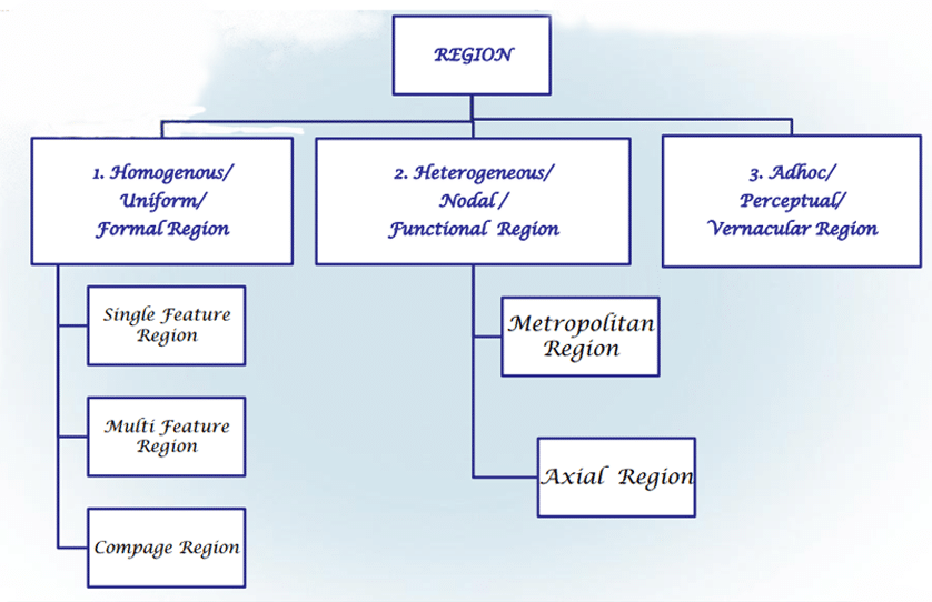
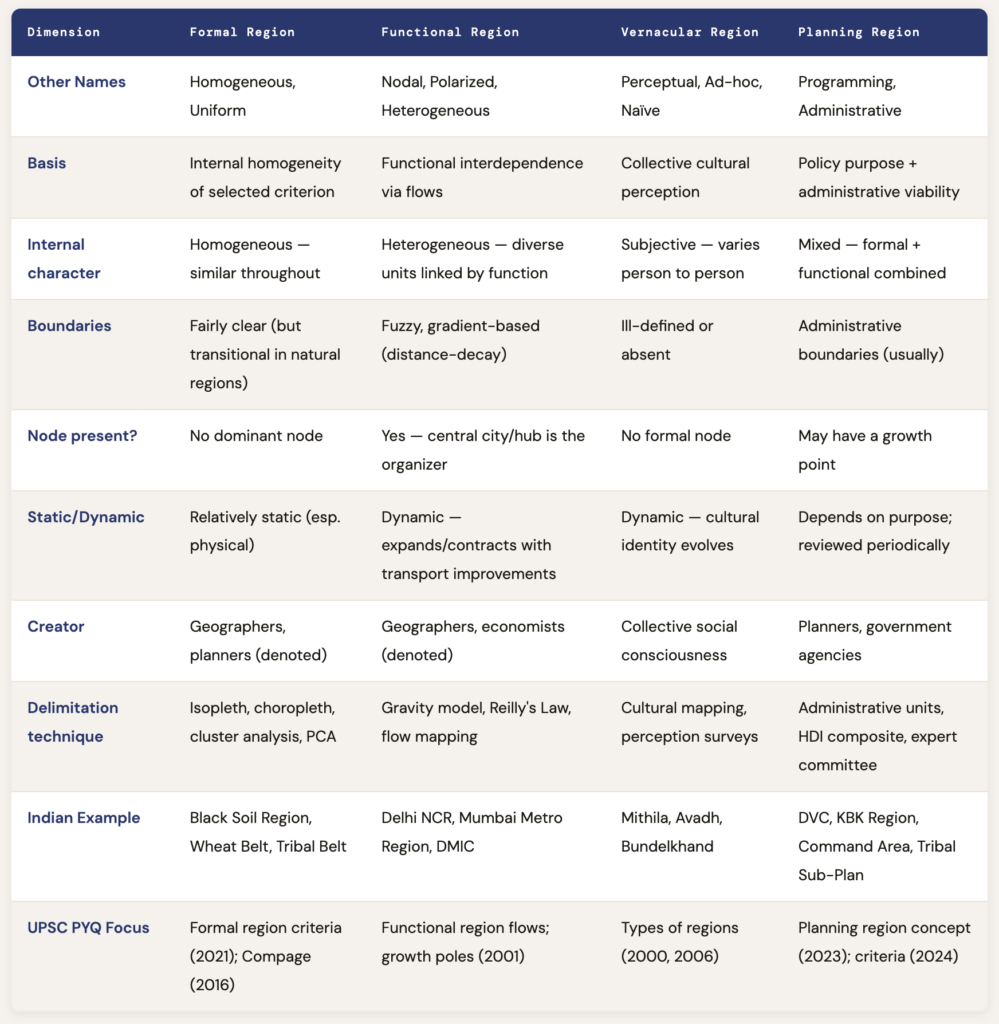
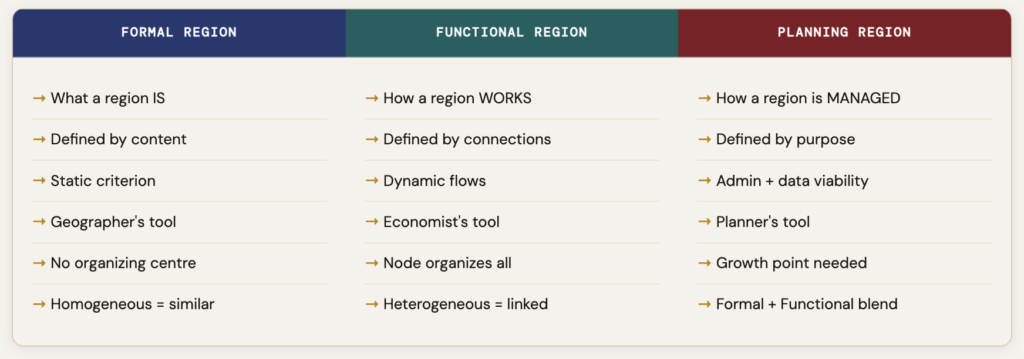
Regions can be classified in many ways. The three most commonly discussed types are formal, functional, and vernacular regions.
Type of Region
Basis
Main Feature
Examples
Formal Region
Homogeneity
Similarity within the region
Himalayan region, black soil region, Hindi-speaking region
Functional Region
Interaction and linkage
Organised around a node
Delhi NCR, Mumbai metropolitan region, port hinterland
Vernacular Region
Perception and identity
Mental map or cultural identity
North India, Bundelkhand, Middle East
Planning Region
Development objective
Area for policy and implementation
Drought-prone area, command area, watershed, Aspirational District
Formal Region (Homogeneous / Uniform Region)
A Formal Region is a geographical region that is homogeneous and uniform within a specified criterion. Uniform regions are homogeneous (or uniform) with respect to certain selected phenomena. They are largely fixed and static. They are identifiable by their composition or assemblage of the phenomena.
In certain formal regions, the characteristic may be predominant rather than universal. For example, the Wheat Belt of North America is an area in which the predominant crop is wheat, but other crops are grown there as well. This is a critical nuance: formal regions are not perfectly homogeneous; they are simply more homogeneous in the selected criterion than the surrounding areas.
Criteria for Formal Region Delimitation
Physical Criteria
Topography, climate, vegetation, soil type. These are geographers’ preferred criteria for natural regions. E.g., Savanna, Tropical Rainforest, Thar Desert, Black Soil Region.
Economic Criteria
Occupational pattern, per capita income, unemployment rate, industrial structure, net migration, density. E.g., Industrial Region, Agricultural Region.
Cultural Criteria
Language, religion, ethnicity, political allegiance. E.g., Central India Tribal Belt, Hindi-speaking belt, Buddhist cultural zones.
Composite Criteria
Multiple indicators combined. More realistic but requires careful variable selection. E.g., BIMARU region, Backward region, Human Development Region.
Sub-Classification of Formal Regions (Whittlesey’s Framework)
Geographer D.S. Whittlesey — who defined region as “a differentiated segment of the Earth’s surface” — provided a three-part classification of formal regions:
Type
Definition
Indian Example
Global Example
Single Feature Region
Delimited on the basis of one criterion only — a single physical, economic, or cultural variable
Physiographic regions of India (topography), Rainfall regions (isohyets)
Tundra (temperature), Equatorial belt (rainfall)
Multiple Feature Region
Based on several related criteria combined — a more realistic but complex approach
Mediterranean region (climate + vegetation + land use combined)
Compage Region
The most holistic formal region — where ALL features of physical, biotic, and social environment are functionally associated with human occupance (Whittlesey, 1956)
Agricultural regions of India’s Indo-Gangetic Plain (soil + water + crop + culture + economy together)
Agricultural regions of the world (Whittlesey’s 13 world agricultural regions)
Whittlesey defined a Compage region as a uniform region where all the features of the physical, biotic, and social environment are functionally associated with the human occupancy. The compage concept captures the full integration of natural and human systems within a region — it is not merely physical homogeneity but the total human-environmental complex considered as a coherent whole.
Whittlesey’s concept of “compage” explained that regional geography is not mere description but involves functional relationships between human, physical, and biotic environments. It showed that general principles can only be identified through particular cases, and vice versa.
Characteristics of Formal Regions
Static and fixed: Their boundaries are relatively stable over time — a formal region defined by soil type does not change season to season
Identifiable by composition: Defined by what the region contains, not by internal flows or connectivity
No dominant node: Unlike functional regions, there is no single organizational centre — homogeneity extends throughout
Transitional boundaries: Natural formal regions almost always have transitional zones rather than sharp lines — the semi-arid zone merges into the arid gradually
Homogeneous problem-bound entity: A homogeneous region is also a homogeneous problem-bound entity — its internal similarity means it shares common challenges
“A homogeneous economic region can have differing physical characteristics. Scotland or Uttar Pradesh are clear-cut homogeneous regions, but in topography, the hilly districts of Uttar Pradesh have nothing in common with the districts of the plains. Yet Uttar Pradesh remains a homogeneous region in administrative terms.” — S. Rengasamy, Madurai Institute of Social Sciences
Critical Nuance: A formal region defined on economic criteria may have significant heterogeneity from a physical standpoint, and vice versa. The internal differences in a region are unimportant relative to the chosen criterion — what matters is that the region is more homogeneous on that criterion than the areas outside it.
Functional Region (Nodal / Heterogeneous / Polarized Region)
A Functional Region is a geographical area that displays a certain functional coherence — i.e., interdependence of parts. It is composed of heterogeneous units such as towns, cities, and villages, which are functionally interrelated and working as a system.
Also called Nodal Region, Polarised Region, or Heterogeneous Region.
Nodal regions differ from uniform (formal) regions in that the places included in them are defined as similar, not because they are homogeneous with respect to certain selected criteria, but rather because they are all tied to the same central place by the movement of people, ideas, and things.
In other words, they all experience more spatial interaction with the same central place or node than they do with any other.
The Flows That Define Functional Regions
The relationships in functional regions are studied in the form of flow — functional flow between towns and villages. The criteria taken for the identification of a functional region are objective and identifiable:
Type of Flow
What It Measures
Example
Journey-to-work trips
Daily commuting — extent of a city’s labour catchment
Daily commuters to Mumbai from Pune, Nasik; Delhi from Gurgaon, Noida
Shopping trips
Consumer linkage to a central market
Villages visiting district town for weekly bazaar
Flow of goods and services
Agricultural produce flowing to city; manufactured goods flowing back
Milk from dairy cooperatives of Gujarat to Amul processing nodes
Communication flows
Telephone density, newspaper circulation, internet traffic
Newspaper circulation area of The Hindu centred on Chennai
Lead bank regions, NABARD district credit planning
Migration flows
Labour migration attracted by employment in a node
Circular migration of Bihari labour to Punjab for agricultural operations
The Node: Heart of the Functional Region
A node is the core or hub that connects all activities and unifies the region. Nodal region comprises the node, core or hub. Nodal points are always urban centres.
Mumbai as a Node: Mumbai is a node, and the sprawling region has interdependency to the node. Mumbai attracts people from distant places in Uttar Pradesh and Bihar because employment can be found there. The size of a nodal region depends upon the efficiency of means of communications and transportation — an improvement in transport widens the radius of influence and the hinterland gets enlarged, further strengthening the node.
Distance Decay in Functional Regions
A key feature of functional regions is the distance-decay principle: as one moves farther from the node, the intensity of interaction decreases.
An example: the circulation area of a newspaper is centered around the city of publication — the farther away from the city, the fewer people read the newspaper. The forces of distance weaken the linkages of all types, unless it is the linkage of all areas with the capital of the nation.
Types of Functional Regions (with Indian Examples)
Type
Organizing Function
Indian Example
Metropolitan Region
Urban primacy — employment, services, finance
Delhi NCR, Mumbai Metropolitan Region, Bengaluru Metropolitan Area
Industrial Region
Manufacturing node attracting raw materials, labour, markets
Tourist attractions drawing flows of visitors and services
Golden Triangle (Delhi-Agra-Jaipur), Kerala backwaters region
Administrative Region
Administrative headquarters attracting government services, courts, offices
State capitals as nodes for district flows; block HQ for village flows
River Valley Region
Dam/barrage as node organizing irrigation, power, and flood management
Damodar Valley, Bhakra-Nangal system
Axial Region
Develops along a corridor performing a special function
DMIC (Delhi-Mumbai Industrial Corridor) along National Highway 8
Characteristics of Functional Regions
Dynamic: Boundaries change over space and time depending on the intensity of flows — as a city grows, its functional zone expands
Heterogeneous internally: Composed of diverse units (dense urban core, suburbs, semi-urban, rural) linked by function, not similarity
Functional linkages give unity: Interdependence is the organizing principle, not homogeneity
Multiple possible sets: There are a number of possible sets of nodal regions depending on the level of activity specified — smaller node for vegetables, bigger node for automobiles
Element of homogeneity: In a sense, even a nodal region has an element of homogeneity — it combines areas dependent in some trade or functional sense on a specific centre (Meyers)
Heterogeneous units form nodal regions: Functional linkages result in the emergence of dominant nodes — focal points that attract and provide all types of flows. In a hierarchy of settlements, several nodal points receive and provide flows and functions. Each settlement cannot sustain all functions — threshold population is needed for a college, electricity for a cinema, credit-deposit ratio for a bank branch. Since not all settlements can afford all functions, they depend on other settlements, and thus functional linkages develop.
“In practice, the formal and functional regions very rarely overlap neatly, and often vary markedly. We have to ‘carve out’ a planning region after compromising the two approaches. That region becomes the planning region (formal or functional) which is administratively viable.” — Rengasamy
Vernacular Region (Perceptual / Ad-hoc Region)
A Vernacular Region (also called Perceptual Region or Ad-hoc Region) is a place that people believe exists as part of their cultural identity.
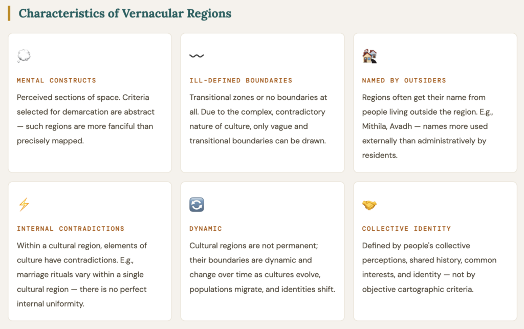
Such regions are “intellectual inventions” — a form of shorthand to identify things, people, and places. Vernacular regions reflect a “sense of place” but rarely coincide with established jurisdictional borders. They emerge from a person’s informal sense of place.
A “vernacular region” is a distinctive area where the inhabitants collectively consider themselves interconnected by a shared history, mutual interests, and a common identity. These regions vary from person to person — they are largely mental constructs and perceived sections of space.
Naïve Region — The Mental Construct Sub-type
A Naïve Region is a mental construct — idealistic, hypothetical, and subjective in nature. It doesn’t have a well-structured association of region-building elements and is vaguely identified. Example: “backward region” as conceptually used in policy discourse, even before a precise technical definition is attached.
Adhoc Region
Adhoc regions are transitional regions — not created on a permanent basis — generally backward regions identified for a specific planning purpose. Here, planning is done with a specific goal in order to develop the particular region. Today, a more comprehensive approach is followed for better planning and development. The vernacular or adhoc region may be formalized over time into an official planning region when policymakers decide to act on the collective perception.
Metaphysical Region — Extreme Sub-type
Metaphysical regions don’t exist in reality — they are more based on philosophy. Examples: the concept of heaven/hell, the Marxist idea of the utopian society. These have no spatial referent whatsoever — they are entirely conceptual.
Indian Examples of Vernacular Regions
Region
State(s)
Basis of Identity
Planning Status
Mithila
Bihar / Nepal border
Maithili language, Madhubani painting, cultural practices
Peninsular geography, distinct Kathiawadi culture, historical princely states
Former state (1948-56), now cultural identity
Planning Region (Programming Region)
A Planning Region is a geographical region where the design and implementation of a development plan is possible for tackling regional problems.
It could be both formal & functional and is generally transitional in nature. Planning regions are the product of compromising between formal (homogeneous) and functional (nodal) approaches.
Boudeville:“It is an area displaying some coherence or unit of economic decisions.”
Klassen:“A planning region must be large enough to take investment decisions of an economic size, must be able to apply its own industry with the necessary labour, should have a homogeneous economic structure, contain at least one growth point and have a common approach to and awareness of its problems.”
Criteria for a Planning Region (C.R. Pathak & Amitabh Kundu)
Large enough to contain a range of resources, conditions, and attributes to serve the desired degree of economic viability, yet not too large to make the comprehensive approach too general (should not lose its uniqueness)
Must have a fairly homogeneous economic structure as well as topographical and socio-cultural homogeneity — e.g., KBK region (Kalahandi-Bolangir-Koraput)
A balance is needed between homogeneity, nodality, and administrative convergence while delimiting a planning region
Must be large enough to enable substantial changes in the distribution of population and employment to take place within its boundaries, yet small enough for planning problems to be tackled effectively
Should have a viable resource base, a manpower base, and internal homogeneity/cohesiveness
Should ensure satisfactory levels of production, exchange, and consumption
Should have at least one growth point — a centre capable of driving regional development
Should enable direct people’s participation in planning
Must have a special data collection unit — data availability is crucial for plan formulation
Narrow internal disparity — too much internal inequality makes unified planning difficult
In practice: Since plan formulation and implementation need administrative machinery, administrative regions are generally accepted as planning regions. This may not be wholly correct — administrative boundaries may be inconsistent with regional boundaries derived from economic criteria. However, data availability and existing administration make this pragmatic compromise necessary.
Types of Planning Regions in India
Type
Description
Indian Example
Metropolitan / City Region
Urban core + functional hinterland; basis for urban master plans and metropolitan development authorities
Delhi Metropolitan Region, Chennai Metropolitan Area, Mumbai Metropolitan Region
River Valley Region
Hydrological unit organizing irrigation, power, flood control; integrates multiple states around a river system
Damodar Valley Corporation (DVC), Bhakra-Nangal system, Chambal Valley
Axial / Corridor Region
Linear development corridor along a transport or industrial spine; performs a special function
DMIC along NH-8, Chennai-Bengaluru Industrial Corridor, Mumbai-Delhi freight corridor
Transitional / Depressed Region
Problem region with composite socio-economic backwardness; identified for special development attention
Area within the irrigation command of a dam/barrage; planned for agricultural intensification and water use efficiency
Nagarjunasagar Command Area, Bhakra Command Area
Special Area Development Region
Areas with unique problems requiring specialized planning — tribal, hill, desert, drought-prone
Tribal Sub-Plan areas, Hill Area Development Programme zones, Desert Development Programme districts
Characteristics of Planning Regions
Can be both formal (homogeneous) and functional (nodal) in character depending on the planning problem
Planning regions are generally arranged in hierarchical patterns — macro, meso, micro (multi-level planning structure)
Suitable for designing and implementing development plans for regional problems such as metropolitan or city regions, river valley regions, axial regions (DMIC), transitional/depressed regions (KBK)
Planning regions are sub-national areas demarcated for the purpose of translating national objectives into regional programs and policies
In most cases, a planning region cannot be as small as a village unless the objective is very limited — a city can be a planning region but a village cluster usually cannot
Types of Regions Based on Stages of Economic Development
From the perspective of development planning, regions are classified into three types based on their level of economic and social development.
1. Developed / Development Regions
Developed regions are those having a high rate of accretion in goods and services — their share in the GDP of the country is relatively higher. This may be with or without rich natural resources, but is certainly due to the use of upgraded technology by highly skilled and motivated persons with an abundance of infrastructure facilities.
Locus of infrastructure facilities in abundance — self-reinforcing “nothing succeeds like success” dynamic
May become ‘overdeveloped’ in certain respects — suffering from diseconomies of congestion; Perroux’s ‘growth pole’ becomes overcritical here
Infrastructure costs become very high; pollution and stresses intensify — counterproductive to further development
A developed region is the counterpart of the backward region — the ‘positive’ side is emphasized
May emerge from comparative advantage or from government diversion of funds to politically influential constituencies
Indian examples: Maharashtra, Karnataka (Bengaluru), Tamil Nadu, Delhi-NCR, Gujarat
2. Backward / Depressed Regions
Backward regions are those where the economy is largely of a subsistence character, co-existing with modern sector regions. They have not come out of the low-level equilibrium trap. Lack of infrastructure, adverse geo-climate conditions, low investment rate, high population growth rate, and low urbanization are simultaneously causes and consequences of backwardness.
Depressed regions have rudimentary industrial activity — major centres of industrial and economic activity are absent or distant
Wide chasms exist in most economic activities, leading to differentials in per capita income and intensity of productive employment
Vestigial regions — a special sub-type: regions inhabited by traditional communities (e.g., tribal groups in India) that remain near the subsistence level. The inhibitions may have ancient traditions and may be smug in their surroundings, but per capita income is much lower than in neighbouring regions
Can be backward due to high population density OR even without it — backwardness is multi-causal
A region can be backward in some respects and not in others — no single indicator captures backwardness fully
Indian examples: Bihar, Jharkhand, Odisha (interior), tribal regions of Chhattisgarh, UTs of Dadra & Nagar Haveli
3. Neutral / Intermediate Regions
Intermediate regions are those which are “islands of development around a sea of stagnation” — positioned between the developed and backward poles. They display neither the self-reinforcing dynamism of developed regions nor the structural deprivation of backward regions.
Experience modest, sometimes stagnant growth — neither takeoff nor decline
Often in transition — may move toward development with appropriate investments or toward backwardness with neglect
May have pockets of development amidst underdeveloped surroundings
Indian examples: Some medium-income states like Madhya Pradesh (post-reform), parts of Andhra Pradesh interior
Dimension
Developed Region
Backward Region
Intermediate Region
GDP share
High and rising
Low and stagnant
Moderate
Infrastructure
Abundant
Deficient
Moderate
Technology
Advanced
Rudimentary/subsistence
Mixed
Urbanization
High
Low
Moderate
Key risk
Overdevelopment, congestion
Low-level equilibrium trap
Stagnation, drift
Policy approach
Manage diseconomies, spread effects
Targeted area programs, basic needs
Investment to trigger takeoff
India example
Maharashtra, Karnataka, Delhi
Bihar, Jharkhand, interior Odisha
MP, interior Andhra Pradesh
Types of Regions: Multi-Level Planning Perspective
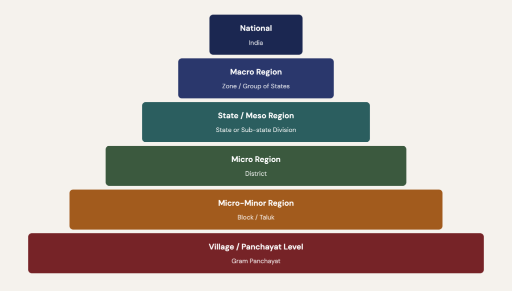
From the perspective of multi-level planning, regions are nested in a hierarchical arrangement from national to village level.
Each level has defined functions, data sources, planning agencies, and linkages to the levels above and below.
The hierarchy of planning regions is: (I) national level → (II) macro level → (III) state level → (IV) meso level → (V) micro level → (VI) micro-minor level.
Types of Regions: Multi-Level Planning Perspective
1. Macro Region
A macro region is naturally bigger than state level — it can be a state or even a group of states, if the states of a country are not big enough to constitute a meaningful macro-regional unit. In India, there are East, West, North, South and Central Zones with Zonal Councils whose function is mutual consultation and developing cooperation.
State boundaries are not necessarily respected — the macro region may transcend or cut across administrative boundaries for project planning purposes (e.g., big river valley projects, electric grid of different states)
A macro region may not be uniform or homogeneous in all respects — it may have physical complementarity but administrative heterogeneity
Should have a common resource base and specialization in that resource base, enabling production based on comparative advantage
India has been divided into 11 to 20 macro regions based on agro-climatic or resource criteria by different scholars
The Planning Commission of India used 5 zonal councils (Eastern, Northern, Central, Western, Southern)
2. Meso Region
A meso region can be identified with a ‘division’ of a state — a sub-state territorial unit comprising several districts with some identifiable affinity.
Can be a cultural or administrative region; ideally a homogeneous physical (resource) region
Can become a nodal region if the combined micro regions can be developed in a complementary manner
NSS of India identified 58 meso regions of India, though they are not shown on maps as formal planning regions
Indian examples: Chhattisgarh region, Bundelkhand region, Baghelkhand region, Mahakoshal region
3. Micro Region (District)
In multi-level planning, the district is the micro region. It is the lowest territorial unit in the hierarchy of planning regions. The most important reason why the district is the most viable micro region for planning is the existence of database and compact administration — this is the area viable for plan formulation with administration for plan implementation and monitoring.
A metropolitan area can be one micro region; its area of influence can be another micro region
Basic characteristic is its smallness and manageability
Can include specific micro regions such as belts of mineral extraction or a command area of an irrigation project
Dantwala Committee (1978) recommended the district as the fulcrum of decentralized planning in India
4. Micro-Minor Region (Block / Panchayat)
The micro-minor region is associated with grass-root planning — a block for which data exists and for which there may be a plan. The block-level plan is integrated with the national plan through the district and state-level plans. The most important test of micro-minor planning is that the people need not look towards the centre for it.
At block level, most officers will be more concerned with implementation than formulation of plans
Main exercise: account for physical and human resources; find prime moving activities to make best use of development potential to meet basic needs
Activities possible at micro-minor level: dairying, animal husbandry, fisheries, poultry, soil conservation, optimizing cropping pattern, agro-based industries
Water harvesting is the most important program for a country like India — micro-minor watershed development
Goal: “Ruralization of industries” — production of goods “by the masses, for the masses, and near the masses”
73rd Constitutional Amendment (1992) formalized the Gram Panchayat as the planning unit at the lowest level
Level
Unit
Scale
Planning Body (India)
Key Function
National
India
1.3 billion+
NITI Aayog
National policy, inter-state allocation, macro targets
Macro
Zone / Group of states
Multi-state
Zonal Councils
Inter-state coordination, resource sharing
State (Meso)
State
State
State Planning Board
State plan formulation, inter-district allocation
Micro
District
Sub-state
District Planning Committee
Plan integration, development vision, data unit
Micro-Minor
Block / Taluk
Sub-district
Panchayat Samiti / BDO
GP plan aggregation, implementation
Village
Gram Panchayat
Local
Gram Sabha
Needs identification, GPDP
Types of Regions Based on Activity Status
A third major classification of regions — separate from the formal/functional/vernacular trilogy — is based on the dominant economic activity that characterises the region. This activity-status analysis is particularly useful for economic geography and industrial location planning.
Type
Basis
Characteristics
Indian Examples
Mineral Regions
Extractive resource concentration — mineral deposits as the organizing economic force
High extraction activity, company towns, environmental degradation risk, boom-bust cycles, infrastructure built around extraction logistics
Chota Nagpur Plateau (coal, iron ore, manganese, bauxite); Bellary-Hospet iron ore belt; Singrauli coal region
Manufacturing / Congested Regions
High concentration of secondary sector activities — industrial agglomeration creating functional economic regions
High employment density, urbanization, pollution, forward-backward linkages, skilled labour pools; risk of congestion diseconomies
Mumbai-Pune industrial belt, Ahmedabad-Surat textile corridor, Chennai auto cluster, Bengaluru IT hub, Ludhiana hosiery region
Cultural Regions
Shared cultural traits — language, religion, traditions, historical memory — as the unifying force
Culturally homogeneous internally, but boundaries always transitional; may overlap administrative regions; basis for political identity claims
Hindi-speaking belt, Central India Tribal Belt, Buddhist cultural zones, Tamil-speaking zone
Important Note on Cultural Regions: Cultural regions are a complex type — their demarcation involves language, religion, and customs, but culture cannot be defined in precise terms. Within a cultural region, elements of culture have contradictions (e.g., marriage rituals vary within a single linguistic region). The boundaries of cultural regions are therefore always vague and transitional — the Buddhist cultural zones in India blend gradually into neighbouring traditions without a clear boundary.
Cultural region
Economic regions
The Formal–Functional Continuum
In practice, the formal and functional regions very rarely overlap neatly, and often vary markedly. The planning region is the result of “carving out” a region after compromising the two approaches, that region which is administratively viable. This is why all practical planning regions contain both homogeneous zones (formal) and functional linkages to a node or corridor.
Tribal Sub-Plan, Mineral regions (Chota Nagpur), Drought-prone area programs
The Thar Desert
Arid climate, sand dunes
Rajasthan arid zone, NW arid plains
Desert Development Programme (DDP), Desertification control, Wind energy planning
The Coastal Plains
Coastal alluvium + laterite
West Coast (Konkan, Malabar), East Coast (Coromandel, Andhra, Orissa)
CRZ regulations, Fisheries planning, SEZ coastal zones
The Islands
Coral atolls + volcanic islands
Lakshadweep (Arabian Sea), Andaman & Nicobar (Bay of Bengal)
Eco-tourism planning, Tribal protection, Climate adaptation, EEZ development
Physical region
Major Functional Regions of India
Delhi National Capital Region (NCR): Delhi as the undisputed node; flows of commuters from Gurgaon, Noida, Ghaziabad, Faridabad; supply of milk, vegetables, newspapers; financial flows from the commercial capital
Mumbai Metropolitan Region: Financial capital as node; Mumbai Port Trust hinterland; commuter flows from Thane, Navi Mumbai, Raigad; Bollywood cultural functional region
Bengaluru Metropolitan Region: IT/ITeS node; skilled labour flows from Kerala, Andhra Pradesh, Tamil Nadu; real estate functional hinterland
Damodar Valley Functional Region: Coal + steel + power as organizing functions; flows of coal from Jharia/Raniganj to DVC power plants; steel from Burnpur to downstream industries
Important Planning Regions of India
KBK Region (Kalahandi-Bolangir-Koraput): Odisha — composite backwardness: hunger, tribal deprivation, outmigration, deforestation; now a formal planning region with Special Plan
Bundelkhand: MP + UP — drought-prone, water-scarce, historically marginalized; Special Bundelkhand Package since 2010
Left Wing Extremism (LWE) Region: 90 districts across 10 states; Integrated Action Plan (IAP) + aspirational district program
North-East India: 8 states treated as a special planning region — Special Category Status, North-East Council, NE Industrial Policy; frontier region characteristics
Command Areas: Nagarjunasagar, Hirakud, Bhakra — formal planning regions defined by dam command
A Mains Master Kit gives you the complete notes, premium articles and PDFs for the whole syllabus. A PYQ Master Pack gives you model answers to every previous year question, topic by topic.
Mains Master Kit: syllabus-mapped notes, updated through the year
PYQ Master Pack: every question since 2013, solved the way toppers write
One-time payment · instant access · no subscription










The efforts made by the Writter of this material is great and awesome….tnq
Thanks
yar shabd kam pad rahen hain aapko dhanyawad dene me
Thank You 🙂
PURE GEM
Covered every aspect of the topic. Great work