

- A flood is a high water level that overtops the natural banks along any part of a stream and spreads over land that is normally dry. A flood along a coast comes from a surge of the sea.
- Flood is natural; flood disaster is partly made by people. A river in spate turns into a disaster when it reaches crops, homes and roads on its floodplain.
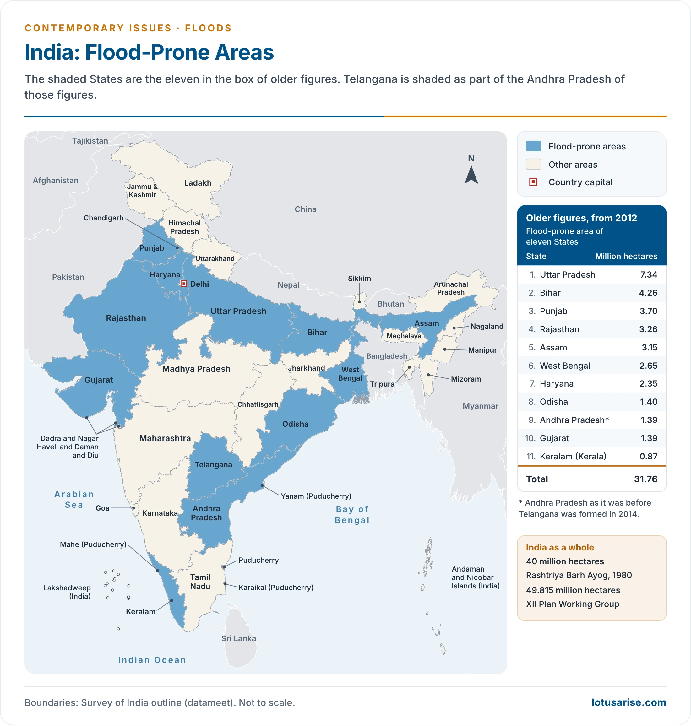
- India’s flood-prone area is put at 40 million hectares by the Rashtriya Barh Ayog (1980), and higher in later official counts. The Ganga and Brahmaputra plains carry the largest share.
Nature and Causes of Floods
Floods
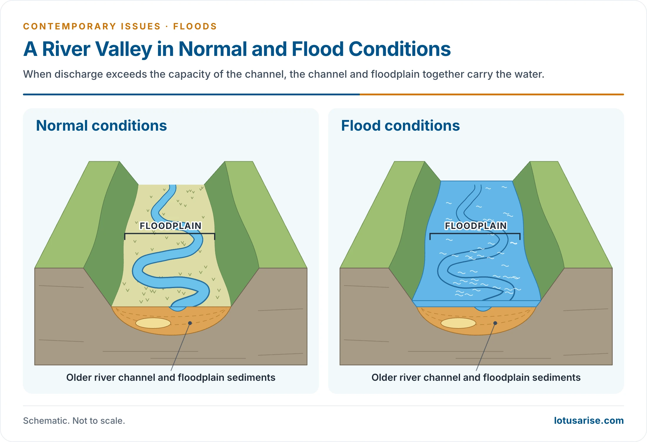
- A stream floods when its discharge exceeds the capacity of its channel. The excess spills over the banks and submerges the adjoining land, so the channel and floodplain together carry the water.
- Floods are commonly tied to a stream or river, and are a normal part of a basin’s hydrological cycle.
- Floods and droughts are its two extremes. Too much monsoon rain gives one, and failed rain gives the other.
- Floods and droughts are, on the one hand, cumulative hazards that build up with the season. On the other hand, the peculiar nature of the Indian monsoon can bring both to different pockets of the country in the same year.
- The Brahmaputra valley can flood while Rajasthan suffers drought.
- Floods are thus seasonal for the most part. Flash floods also occur, with little warning and a short, violent rise.
Causes of Floods
- Compared with many other disasters, the causes of floods are well established. Riverine floods build up relatively slowly, in well-identified regions, at an expected time of year.
- Flash floods and dam failures are the exceptions.
- A serious flood usually needs several unfavourable factors at once, and human activity now sharpens all of them.
| Group | Factors |
|---|---|
| Meteorological | Heavy rainfall; tropical cyclones; cloudburst; heavy melting of ice and snow |
| Physical | Large catchment areas; changes in river systems; inadequate drainage; silting of beds; landslides in river courses; tsunami and sea surges |
| Human | Deforestation; siltation from land misuse; faulty farming and irrigation; collapse of dams; accelerated urbanisation |
Natural Causes
- Heavy rainfall and cloudbursts: concentrated rain leaves rivers unable to accept more surface run-off, and the water spills over the adjoining land.
- Heavy melting of ice and snow, which swells Himalayan rivers.
- Changes in river systems and large catchment areas: the Kosi shifts its course and floods new ground, and a large catchment delivers more water to one channel.
- Sediment deposition and silting of river beds, which reduce channel capacity.
- Transgression of the sea at the time of a tropical cyclone.
- Tsunami in coastal areas, and landslides in the course of rivers, which dam a river and then release a flood.
Cloudbursts
- A cloudburst is very intense rain over a small area. The working measure is 100 mm or more in an hour, over about 20–30 sq km. Older accounts describe thunderstorm rain of over 50–100 cm within a few hours.
- Mechanism: warm, humid air is forced up a mountain slope and builds towering cumulonimbus clouds.
- Weak upper winds fail to disperse them, and the moisture comes down in one spot.
- The extra moisture from wet ground on Himalayan slopes may add to it.
- Where: most frequent in the Himalaya in the monsoon, but rare and severe events occur elsewhere.
- Musi river, Hyderabad (1908): a great flood that destroyed much of the city.
- Leh (August 2010): cloudbursts struck the cold-desert town.
- Mumbai (26 July 2005): the Santacruz station of the India Meteorological Department recorded 944 mm in a day.
- Why they do damage: water, boulders and debris arrive within minutes in narrow valleys, leaving little time to escape.
Man-made Causes
- Unlike many natural disasters, human beings play an important role in both the origin and the spread of floods.
- Deforestation: it causes soil erosion and landslides.
- Vegetation holds the soil, which acts as a sponge and soaks up much of the rain. Once it is lost, run-off rises and river beds silt up.
- Unscientific land use and bad farming practice:
- Fields left bare let soil and water flush into rivers.
- Even the wrong direction of ploughing, up and down a slope, speeds run-off.
- Faulty irrigation: canals and field systems that cut across natural drainage hold water back.
- Collapse of dams: the failure of the Machhu dam at Morvi (1979) drowned the town.
- Increased urbanisation: hard, impermeable surfaces reduce the land’s ability to absorb rain.
- Less water infiltrates, so the volume and rate of surface run-off rise.
- Mumbai’s floods turned on this, along with encroachment and blockage of the Mithi River.
- Living on the floodplain: growing settlement of floodplains and river beds, against the old principle that a river should keep its right of way, places more people in harm’s way.
Consequences of Floods
- Although floods are only a temporary inundation, they do extensive damage. Their frequency, intensity and magnitude are rising, and they now cause more damage than almost any other single disaster.
- Lives and property: floods take lives and destroy property every year.
- Crops: the agricultural season is temporarily lost, and fertile soil cover may go with it.
- Habitats and animals: habitats are changed or destroyed, and animals drown.
- Communication and services: breaks in rail and road links and in essential services stop the movement of people and goods.
- Health: water-borne and infectious diseases such as cholera and gastro-enteritis spread soon after floods.
- Positive consequences: floods also deposit fertile silt on fields, which is good for crops, and recharge the groundwater table.
- Scale: for 1953–2010, a Parliamentary Standing Committee report gave an average of about 7.2 million hectares affected each year.
- Over three-fourths of the crop and property damage falls on the northern plains: Punjab, Haryana, Uttar Pradesh, Bihar, West Bengal and Assam.
- The poorest, living at the edge of settlements, are usually hit hardest.
Flash Floods and Glacial Lake Outbursts
- A glacial lake outburst flood (GLOF) is the sudden release of water from a lake held back by moraine or ice.
- Triggers: avalanches, debris flows, rock falls or landslides into the lake; earthquakes; thawing permafrost; heavy rain.
- Vulnerable types: moraine-dammed, ice-dammed and ice-cored lakes.
- Effect: a wall of water and debris that can travel far down the valley with very little warning. Retreating glaciers are enlarging such lakes.
- Kedarnath, 16–17 June 2013: heavy rain filled Chorabari Tal, less than 4 km above Kedarnath. It overflowed and possibly burst through its moraine rim, and the town was almost wholly destroyed.
- The National Institute of Disaster Management reported in 2013 that 169 had died and 4,021 were missing, the missing being later presumed dead.
- The event was called the Himalayan Tsunami, since monsoon and westerly systems had combined over the Himalaya.
- Causes argued over: rain and glacial melt are the natural side. Environmental groups also blame illegal construction on floodways, road widening, hydropower blasting and heavy pilgrim traffic, which they call a man-made share of the disaster.
- South Lhonak, Sikkim, 3–4 October 2023: the lake’s outburst swept down the Teesta and destroyed the Teesta III dam at Chungthang.
- Dharali, Uttarkashi, 5 August 2025: a debris-laden flood down the Kheer Gad buried much of the village. The Ministry of Jal Shakti first reported a cloudburst, but others pointed to a landslide or a blocked valley. The State ordered a technical inquiry.
- Response: the National GLOF Risk Mitigation Project (2024) has an outlay of Rs 150 crore for Arunachal Pradesh, Himachal Pradesh, Sikkim and Uttarakhand. About 195 lakes are listed as at risk.
- The Central Water Commission monitors 2,843 glacial lakes and water bodies over 10 hectares from June to October each year (May 2026). It reports 46 Himalayan hydropower projects as vulnerable, all now with early warning systems.
- Other steps include mapping and monitoring, heeding forecasts, and building to hydrological and ecological principles.
Flood-Prone Areas of India
Flood Distribution in India
- Floods recur in India and bring heavy losses to lives, property, livelihoods, infrastructure and public utilities.
- Extent: 40 million hectares out of a geographical area of 3,290 lakh hectares is prone to floods, which is about 12%, or one-eighth of the land.
- The Rashtriya Barh Ayog (National Commission on Floods), set up in 1976, gave this figure in 1980. It found the flood-prone area had grown from 25 million hectares in the 1960s to 34 million in 1978.
- Its method, adding each State’s worst year, has been criticised, as floods can reach land not hit in that year.
- The XII Plan Working Group revised the figure to 49.815 million hectares.
- State shares of damage: an older State-wise study put about 27% in Bihar, 33% in Uttar Pradesh and Uttarakhand, and 15% in Punjab and Haryana.
- Uttar Pradesh and Bihar hold about a third of the flood-prone area.
- Main zone: the Ganga–Brahmaputra–Meghna basin, which accounts for nearly 60% of the country’s total river flow. The flood problem concentrates where the water does.
- North Indian rivers: the middle and lower courses of the Ganga, Brahmaputra and Kosi flood because of their very low gradient. The flat plains offer too little slope to drain the water.
- The Damodar and Mahanadi, though Peninsular rivers, also flood in their lower courses.
- Peninsular rivers: these are mature rivers with hard rock beds and stable courses, in shallow valleys. Floods are less serious overall and are worst in the deltas and lower reaches, where silt builds up.
- East coast: parts of it are particularly prone to cyclones in October–November, with a smaller season in April–May. These bring strong winds, storm surges, tidal waves and torrential rain.
| Flood region | Rivers | Why it floods |
|---|---|---|
| Ganga River Region | Yamuna, Gomati, Ghaghra, Gandak, Kosi, Son, Burhi Gandak, Bagmati, Mahananda, Damodar | Tributaries from both the Himalaya and the Peninsula; low gradient; silt; drainage congestion |
| Brahmaputra River Region | Brahmaputra and its tributaries, Barak | Over 250 cm of rain; heavy silt; narrow valley; earthquakes |
| North-West River Region | Satluj, Beas, Ravi, Chenab, Jhelum, Ghaggar, Markanda | Poor surface drainage; waterlogging; man-made barriers |
| Central and Deccan India | Mahanadi, Godavari, Krishna, Cauvery, Narmada, Tapi | Stable courses overall; silted deltas; high tides; cyclones |
- Ganga River Region:
- Uttar Pradesh: eastern districts flood through the Rapti, Sharda, Ghaghra and Gandak. The west has drainage congestion around Agra, Mathura and Meerut.
- Bihar: floods are almost annual in the north, through the Burhi Gandak, Bagmati, Kamala, Kosi and Mahananda. The Kosi is known for its shifting course: on 18 August 2008, its embankment breached at Kusaha in Nepal and the river took up an old channel, flooding land long thought safe.
- West Bengal: the south and centre flood through the Mahananda, Bhagirathi, Ajoy and Damodar, because of inadequate channel capacity and tidal effect. Floods have continued on the Damodar even after its dams were built.
- Delhi: the Yamuna reached a record 208.66 m on 13 July 2023, above the 207.49 m of 1978.
- Brahmaputra River Region:
- Floods are almost annual on the Brahmaputra and its tributaries, where heavy rain, silt and valley form all work against drainage.
- The valley is narrow, about 80 km at its widest, and the bed has been raised by silt. Earthquakes such as those of 1897 and 1950 have changed river levels.
- 31.05 lakh hectares out of 78.52 lakh hectares, nearly 40% of Assam, is flood-prone (Rashtriya Barh Ayog, on Assam’s official figures).
- Assam, 2026: the State Disaster Management Authority’s count reached 104 deaths by 14 August 2026, with Upper Assam districts such as Sivasagar and Golaghat badly affected.
- North-West River Region:
- Punjab: floods are near-annual, with intense ones every 4–5 years. Canals, highways and railways built across the natural slope obstruct drainage, along with building in low-lying areas near Ludhiana and Patiala.
- In 2025, 12 of its 23 districts were affected by early September.
- Haryana: a saucer-shaped surface stops free run-off, so that even moderate rain can flood it.
- Ghaggar: it once died out in the Rajasthan sands, and now occasionally submerges land there.
- Jammu and Kashmir: the Jhelum raises Wular Lake and threatens Srinagar. The Chenab and Tawi endanger Jammu and Akhnoor.
- Punjab: floods are near-annual, with intense ones every 4–5 years. Canals, highways and railways built across the natural slope obstruct drainage, along with building in low-lying areas near Ludhiana and Patiala.
- Central and Deccan India:
- Rivers are mostly stable, so floods are a smaller problem. The Mahanadi, Godavari, Krishna and Cauvery deltas flood through silting and shifting channels, and high tide makes it worse.
- Keralam (Kerala): short rivers from the Western Ghats do heavy damage when in spate.
Flood Management
Flood Control Management
- The Central and State Governments use structural measures, which modify the flood, and non-structural measures, which modify the damage.
- After the floods of 1954, the main thrust was on reservoirs, embankments, channel works, town protection and river training.
Flood Forecasting
- Purpose: advance notice of a flood gives time to move people, cattle and goods, and so cuts the loss.
- Start: the Central Water Commission (CWC) began flood forecasting in November 1958, with its first station at the Old Railway Bridge, Delhi.
- Network: the older figure of 175 stations dates from 2014. By 2 May 2026, the network had grown to 360 flood forecasting stations (201 level and 159 inflow), drawing on 1,543 hydrological stations and 1 central and 36 divisional control rooms. It covers the flood-prone States and Union Territories.
| Year | Forecasting stations |
|---|---|
| 1958 | 1 |
| 1985 | 145 |
| 2014 | 175 |
| 2019 | 325 |
| 2026 | 360 |
- Season: daily warnings run through the flood season, usually given as May to October. The Commission now uses three periods:
- 1 May–31 October in the Brahmaputra, Barak and Jhelum basins;
- 1 June–31 October in other basins up to the Krishna;
- 1 June–31 December south of the Krishna.
- Activities: collecting river and weather data; sending it to forecasting centres; analysis and formulation of a forecast; and dissemination.
- State control rooms pass warnings on and organise relief and rescue.
- Accuracy: a level forecast is counted accurate if within 15 cm, and an inflow forecast if within 20% of actual discharge.
- New tools: the Commission now issues 7-day advisory forecasts and runs the FloodWatch India app.
- C-FLOOD, launched on 2 July 2025 with the National Remote Sensing Centre and the Centre for Development of Advanced Computing, gives 2-day inundation forecasts down to village level. It began with the Godavari, Tapi and Mahanadi basins and is planned to cover all forecasting stations by 2027.
- Across borders: a flood data arrangement with Nepal dates from 1988. India’s data memoranda with China on the Brahmaputra and Satluj lapsed in June 2023 and November 2020, and India has pressed for renewal.
Reduction in Run-Off
- This works well because run-off falls when more surface water infiltrates in the catchment, above all through large-scale afforestation in the upper catchment.
- The canopy intercepts raindrops, while roots, leaf litter and humus hold water.
- Less run-off means less soil erosion, so there is less silt and the channel keeps its capacity.
- In the Indo-Gangetic plain, dug wells along seasonal channels can force water underground, as its soft soils and large aquifers allow.
Construction of Dams
- Dams and multipurpose projects store surplus water in reservoirs and release it under control, cutting flood peaks.
- Several were built in the First Five-Year Plan, and many more in later plans.
- Examples: Tilaiya, Konar, Maithon and Panchet in the Damodar system; Bhakra on the Satluj; Hirakud on the Mahanadi; Pong on the Beas; Nagarjuna Sagar and Tungabhadra in the Krishna basin; Ukai on the Tapi.
- Ponds, tanks, marshes and old quarries serve as smaller detention basins.
Channel Improvements and Construction of Embankments
- Channel improvement: flood-prone rivers are deepened and widened, and their beds cleared and straightened. Banks are held by riprap, spurs and deep-rooted trees.
- Diversion into canals and depressions: water from such rivers is led into canals, which store it for a time. The Ghaggar scheme diverts 340 cumecs into depressions before the river enters Rajasthan.
- Embankments: the Central and State Governments have raised many, along the Brahmaputra, Krishna, Godavari, Gandak, Kosi, Narmada, Tapi, Son, Satluj and their tributaries.
- Older figures show the scale: about 10,821 km by 1978 and more than 33,630 km by March 2000. Assam holds about a third, with 934 km on the Brahmaputra and 2,400 km on its tributaries, and Bihar about a fifth.
- Limits: they shift a flood more than they control it. Silt confined to the channel raises the bed, and a breach can then be worse than the flood it was built to stop. The Kosi in 2008 is the standard case.
Flood Plain Zoning
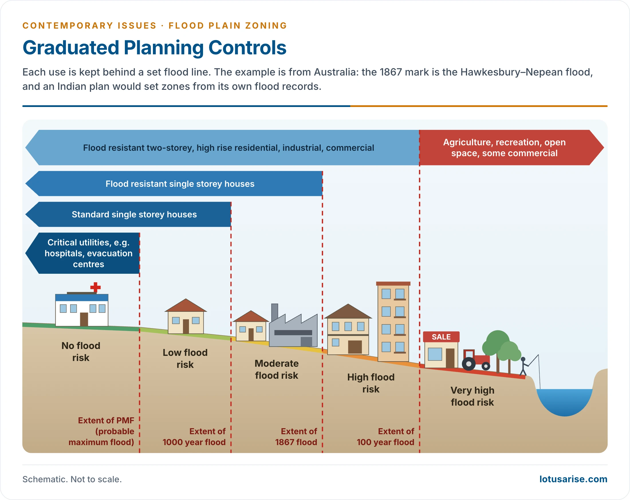
- This rests on information about floodplains: which strips act as floodways, and how the land along them is used. Flood-prone land is mapped and graded, and the use of each zone is controlled.
- The Central Flood Control Board proposed zoning in 1957, and a model bill went to the States in 1975.
- Its features were a zoning authority, delineation and notification of limits, restrictions on use, compensation, and power to remove constructions.
- By May 2026, eight States had adopted it through an Act or policy: Manipur, Rajasthan, Jammu and Kashmir, Uttarakhand, Bihar, Arunachal Pradesh, Assam (Bodoland Territorial Council) and Tamil Nadu.
NDMA Guidelines for Flood Management
| Structural | Non-structural |
|---|---|
| Reservoirs, dams, other water storages | Flood plain zoning |
| Embankments and flood walls | Flood proofing |
| Drainage improvement | Flood management plans |
| Desilting and dredging of rivers | Integrated watershed management |
| Diversion of flood water | |
| Afforestation and catchment area treatment |
- Watershed management links run-off control with both land and water use.
Government Programmes for Flood Management
- Legislative measures: construction of industrial and residential units in flood-prone areas is to be restricted, and buildings, factories and houses are to be kept out of zones next to the channel.
- Land flooded only occasionally should stay under green belts, with social forestry encouraged on the floodplain.
- National Flood Control Management Programme, 1954: the first national policy statement on flood control, given on 3 September 1954, set out three types of measures:
- Immediate (about two years): data collection and emergency protection.
- Short-term (the next few years): spurs and embankments at selected sites.
- Long-term: storage reservoirs on rivers and tributaries, and further embankments.
- National Hydrology Project, 2016: a central sector scheme of Rs 3,679.77 crore, with 50% of the outlay from a World Bank loan. It gathers hydro-meteorological data for storage and analysis in real time, open to any user at State, district or village level.
- Flood Management and Border Areas Programme, 2021–26: Rs 4,100 crore in all, approved in February 2024.
- Rs 2,940 crore is for flood control, anti-erosion, drainage and anti-sea erosion works, with central funding of 90% for special category States and 60% for others.
- Rs 1,160 crore is for works on rivers shared with neighbouring countries.
- Protection so far: of the 40 million hectares, about 32 million was judged protectable by structural means.
Mitigation (Post-Flood Management)
- Rescue operations
- Speedy restoration of the transport system
- Supply of safe drinking water
- Repairing power, telephone and sewerage lines
- Providing food, shelter and clothing
- Survey to assess the loss and compensation
- Rehabilitation of properties
- Desilting and dewatering of inundated areas
- Contingency plan for the agriculture sector
- Community resilience: local warning, shelters and trained volunteers, along with risk-based planning, reduce the toll at each stage of the flood cycle.
Previous Year Questions
2026Disaster risk reduction and community resilience are the two pillars that need to be prioritized in the flood prone areas of India. Critically analyse.2026With suitable examples describe the hazards of flood plain settlement.2025Explain the causes of glacial lake outburst flood.2023Discuss the problems of floods and their management with special reference to the Indo-Gangetic Plain.2022The incidence of extreme rainfall events and flash floods in recent times has led to devastating consequences for people living in low-lying areas and flood plains of the country. Discuss.2021Describe the problems of cloudburst in India, giving suitable examples.2019Examine the problems of Glacial Lake Outburst Flood (GLOF) in India.2019The impact of floods on life and property can be most effectively reduced by hazard mapping. Comment.2018Explain the natural and anthropogenic causes and mitigation measures of frequent flooding in Mumbai.2016Describe the flood-prone areas and their management problems in the Ganga Plains.2015Account for the growing frequency and intensity of floods in India, and suggest short- and long-term remedial measures indicating the chronically flood-prone areas.2012Explain the causes, impact and remedial measures of flood-hazards in the middle Ganga plain. Represent the flood-affected areas of middle Ganga plain on a sketch map in your answer-book.2005Give an account of the distribution of flood-prone areas of India and the programmes and policy of controlling the impact of floods in the country.2004Explain the causes, impacts and remedial measures of flood-hazards in Middle and Lower Ganga plain.2000Give a reasoned account of either flood hazards or drought hazards occurring in India, and also suggest measures for controlling them.1993Delineate the flood-prone areas of India by drawing a sketch map in the answer book and discuss the causes and consequences of floods in the North Indian plains.





The content is good ..no doubt !
It will be better if u post previous years asked questions related to that particular topic .
Okay, Thanks for the feedback, I will include the previous year’s questions.
yes it will prove more edge to your site by incorporating topic wise notes along with PYQ.
Zabardast
Thank you for creating such an amazing site. Thank you so much.