

- A drought is a period when water or moisture falls well short of what is normal or expected for an area. It is a temporary shortage, and it builds slowly.
- It starts with rain, passes to rivers, soil and crops, and ends in loss of food, income and work. Each stage is a separate type of drought.
- India’s southwest monsoon of 2026 closed at 87% of its long period average, the weakest since 2015, and several States declared drought.
Drought
Meaning
- Drought is a temporary fall in water or moisture below what an area normally gets over a given span.
- It also means substantially lower than average precipitation in a season that normally has ample precipitation to support cereal and non-cereal crops.
- A wider official view takes it as any lack of water for the normal needs of farming, livestock, industry or people, whether from poor rain, poor irrigation or under-use of supplies.
- Scientifically, it is an adverse moisture index. This reflects low rain, but also high temperature, heavy evapotranspiration and soil that holds little water.
- The amount, time and distribution of rainfall all matter. Rain may fall short, or be enough in total yet separated by a long dry gap.
- In India, an erratic summer monsoon, with long dry spells and high temperature, causes drought conditions.
- Frequency: on average one year in every five is a drought year. In Rajasthan, one year in every three is a drought year.
- Relative phenomenon: the shortage is judged against the agro-climatic conditions of the place.
- In Jaisalmer (about 200 mm of rain), a drought means too little water even for grass and coarse grains. In Bolangir or Koraput (Odisha, over 1,000 mm), it means too little to bring the paddy to maturity.
- Aridity is a permanent condition, whereas drought is a temporary situation. Arid and semi-arid regions are the most prone to drought.
Types and Causes of Drought
| Type | What falls short | Main causes | Indian setting |
|---|---|---|---|
| Meteorological | Rainfall, against the local mean | Lean monsoon; late onset or early withdrawal; long breaks | Rajasthan; rain-shadow Deccan |
| Hydrological | Surface water and groundwater | Deforestation; hazardous mining; over-pumping | Doon valley streams; plateau aquifers |
| Agricultural (soil moisture) | Soil moisture for crops | Erratic rain; thirsty varieties; changed cropping | Punjab rice; Maharashtra sugarcane |
| Socio-economic | Food and income | Crop failure | Rainfed districts |
| Ecological | Productivity of natural ecosystems | Water stress, environmental damage | Forests and wildlife in dry years |
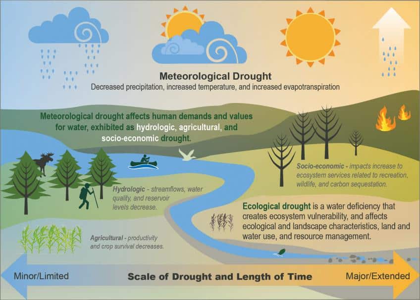
- This chart shows how a shortage of rain passes into the other types, with scale and duration growing from left to right.
Meteorological Drought
- Rainfall falls below a set amount for a specific period (days, months, a season or a year), so that actual rainfall is well under the climatological mean.
- The India Meteorological Department (IMD) definition: a drought exists where the year’s average rainfall drops under 75% of normal.
- A deficiency of 26–50% is moderate and over 50% is severe.
- An all-India drought year was one with a deficiency above 10% and more than 20% of the country under drought.
- In January 2016, IMD stopped using “drought” for the national monsoon and adopted “deficient year” and “large deficient year”, since declaring drought rests with the States.
- Evenness matters more than total: IMD stresses that distribution, not the seasonal sum, decides the effect. India has an average annual rainfall of 110 cm on one common figure, yet the erratic, concentrated monsoon brings frequent droughts.
- Causes of meteorological drought:
- Lean monsoon and below-average rainfall, with few depressions.
- A monsoon that arrives late or leaves early.
- Long breaks within the season.
- The monsoon’s upper-air circulation also plays a part: the southern branch of the jet stream can re-establish itself during the season. El Niño years such as 2002, 2009 and 2015 brought weak monsoons.
| Rainfall behaviour | Sign of drought |
|---|---|
| Deficient rainfall | Under 75% of the normal |
| Delay in onset | Up to three weeks after the normal date |
| Timely onset, then break | A break of up to two weeks |
| Early withdrawal | Withdrawal from north-west India as early as late August |
Hydrological Drought
- It is linked with a reduction of water levels. It usually follows meteorological drought, and generally needs two successive dry years to set in.
- It takes two forms:
- Surface water drought: the drying up of rivers, streams, lakes, ponds, tanks and reservoirs.
- Groundwater drought: a fall in the groundwater level, which pumping can keep going even in years of normal rain.
- Causes of hydrological drought:
- Large-scale deforestation, the main cause on the surface.
- Ecologically hazardous mining, with road building and unterraced farming. Limestone quarrying in the Doon valley turned perennial streams into monsoon torrents.
- Excessive pumping of groundwater, without replenishment.
- Recharge differs by region: the soft alluvium of the northern plain takes up water readily, while the hard rock of the Peninsula does not.
Agricultural Drought
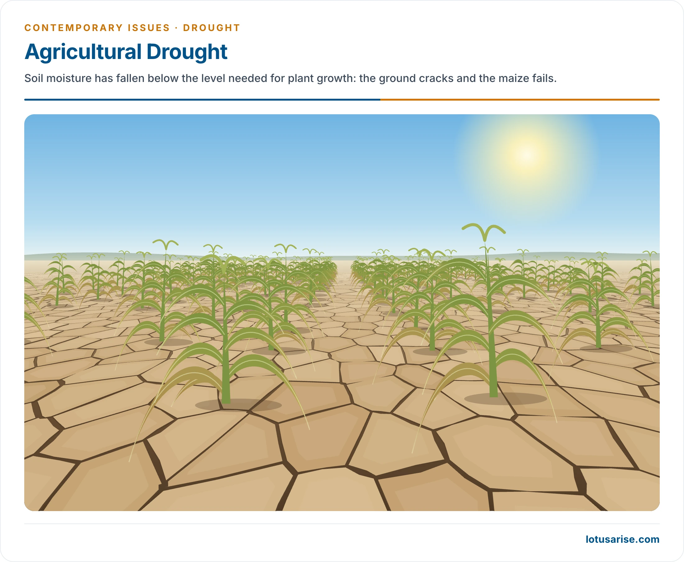
- It occurs when soil moisture falls below the level needed for plant growth. It is also called soil moisture drought. Erratic rain and thin moisture reserves lead to crop failure.
- It can occur without meteorological drought, and the reverse is also true.
- It is relative to the crop. Conditions that are too dry for rice may suit wheat, and be too wet for bajra or jowar.
- Extreme, lasting soil-water failure leads towards desertification.
- Causes of agricultural droughts:
- Excessive use of High Yielding Varieties (HYV), since these seeds need more water and proper irrigation, and have replaced traditional drought-resistant seed.
- Change in cropping pattern: with the Green Revolution, wheat and rice output rose. Rice is water-intensive, so growing it where water is scarce made these areas prone to agricultural drought.
- Punjab, Haryana and western Uttar Pradesh get about 50–75 cm of rain, where rice normally needs about 100 cm.
- In drought-hit Maharashtra, Karnataka and Andhra Pradesh, scarce water goes to sugarcane and grapes before staple crops. Here, drought comes from how water is allotted as much as from how much there is.
Socio-Economic Drought
- It reflects reduced availability of food and loss of income due to crop failure, and puts livelihoods and food security at risk.
- At its extreme, famine is a wide breakdown in people’s access to food, ending in mass starvation unless relief arrives.
Ecological Drought
- It occurs when the productivity of a natural ecosystem fails because of water shortage. The environmental damage includes deaths of cattle, wildlife and forest trees.
Droughts in India
Basic Facts
- Droughts in India have their own peculiarities:
- Rainfall: the annual average is around 1,150 mm, high by world standards, with considerable variation from year to year.
- Some large countries receive more: World Bank data (2017) gives Brazil 1,761 mm and Indonesia 2,702 mm, against 1,083 mm for India.
- Monsoon totals are measured against a June–September long period average of about 87 cm, based on 1971–2020.
- Concentration: more than 80% of the rain falls in less than 100 days of the southwest monsoon, and it is unevenly spread.
- Dry belt: 21% of the area receives less than 700 mm a year, which makes it a hot spot of drought.
- Rainfed farming: inadequate rain and an adverse land-man ratio leave large parts of the country under rainfed farming, about 45% in older accounts and about half of net sown area in recent ones. Rainfed and dryland agriculture is the most exposed.
- Water supply: per capita water availability is steadily declining.
- Groundwater irrigation makes matters worse in the long run, as withdrawal exceeds replenishment.
- In the Peninsula, surface water itself becomes scarce in years of poor rain.
- Rainfall: the annual average is around 1,150 mm, high by world standards, with considerable variation from year to year.
Most Drought-Prone Areas in India
- Definitions: a drought-prone area has more than a 20% chance of a drought year, and a chronically drought-prone area has more than 40%. A drought year means less than 75% of normal rain.
- Extent: about 30% of the country’s total area is drought-prone, affecting 68% of the total sown area.
- An older reckoning puts the hard core at 16% of the area and 12% of the people, and the whole at about 10 lakh sq km, one-third of the land.
- 77 districts with under 75 cm of rain held 34% of the net sown area, and 22 more with 75–85 cm held 9% of cultivated land.
- North-West region: the arid and semi-arid zone receives only the residual rain of the monsoon, whose stay lasts nearly two months. Rajasthan and some west-central areas fall here.
- This desert and semi-desert block covers about 6 lakh sq km, roughly a rectangle bounded by lines from Ahmedabad to Kanpur and from Kanpur to Jalandhar.
- Kutch and the Thar are naturally drought-prone. This cannot be fully rectified, but irrigation methods and suitable crops can reduce its impact.
- Peninsular region: the leeward (rain-shadow) side of the Western Ghats receives little rain and lacks irrigation.
- The belt is up to about 300 km wide and covers about 3.7 lakh sq km.
- Commercial crops chosen for it, such as cotton and sugarcane in Marathwada, demand far more water than the region has.
- Isolated pockets, about 1 lakh sq km in all: Coimbatore and Tirunelveli (Tamil Nadu); Saurashtra and Kachchh; Jhansi, Lalitpur, Banda, Mirzapur, Pilibhit, Kheri and Bahraich (Uttar Pradesh); the Palamau plateau (Jharkhand); Purulia (West Bengal); Kalahandi (Odisha); large parts of Uttarakhand; Jammu and Udhampur.
- Wet-area droughts: some of the worst droughts have struck West Bengal, Bihar and Odisha, where rain is normally plentiful and failure hits dense populations.
- Frequency of highly deficient rain by meteorological sub-division (India Meteorological Department):
| Sub-divisions | Recurrence |
|---|---|
| Assam | Very rare, once in 15 years |
| West Bengal, Chhattisgarh, Bihar, Madhya Pradesh, Coastal Andhra Pradesh, Maharashtra, Konkan, Keralam (Kerala), Odisha | Once in 5 years |
| South interior Karnataka, Eastern Uttar Pradesh, Vidarbha | Once in 4 years |
| Gujarat, Eastern Rajasthan, Western Uttar Pradesh, Tamil Nadu, Kashmir, Rayalaseema, Telangana | Once in 3 years |
| Western Rajasthan | Once in 2.5 years |
Severe Drought Years
- Severity-wise, 1965, 1972, 1979, 1987, 2002, 2009 and 2012 rank as the most severe drought years of post-independence India.
- Longer spells are often given as 1965–67, 1972–73, 1979–80 and 1985–88.
- 2002 ended 19% below normal and 2009 ended 22% below.
- 2014 and 2015 were two deficient years in a row, with 2015 at 86% of the long period average.
- The 2026 monsoon (India Meteorological Department, 30 September 2026):
- Rainfall was 759.4 mm, or 87% of the long period average, the 4th lowest since 2001 and 13th lowest since 1901.
- 17 of 36 sub-divisions, 42% of the area, were deficient. June alone stood at 65%.
- East and North-East India recorded 1,017.1 mm, its lowest since 1901. The South Peninsula stood at 76%.
- State declarations by the end of October:
- Karnataka from 27 August (217 of 240 taluks by 2 October).
- Maharashtra in late September (265 talukas), raised to 305 of 358 on 14 October.
- Andhra Pradesh on 2 October (388 mandals in 21 of 28 districts).
- Rajasthan on 26 October (80 tehsils in 14 districts) and Gujarat on 26 October (Kutch, Devbhumi Dwarka, Jamnagar and Porbandar).
- Telangana on 27 October (365 mandals in 31 districts, 111 of them severe).
Effects and Response
Consequences of Droughts
- The direct impact is generally classed as social, economic and environmental. The relative and absolute size of each depends on regional characteristics.
- A drought usually works through in sequence: crops fail, work disappears, purchasing power falls, stocks run out, and people sell assets and migrate.
- Economic losses:
- A decline in cultivated area and a fall in agricultural production, including milk.
- Less farm employment and less purchasing power, which slows secondary and tertiary activities.
- Higher prices, and distress sale of cattle, land and jewellery.
- Rainfed land is hit first. Buffer stocks of grain have made the threat smaller than before the Green Revolution.
- Environmental impact:
- Damage to plant and animal species, wildlife habitat, air and water quality, along with forest and range fires, poorer landscape quality and soil erosion.
- Soil moisture, surface run-off and the groundwater table are all adversely affected. Wells and tube wells can run dry.
- Impact on society:
- Migration away from the stricken areas, for work and food.
- Farmer suicides: older accounts named Maharashtra, Andhra Pradesh and Karnataka as having the most.
- The National Crime Records Bureau report for 2024 (released 7 May 2026) counts 10,546 farm-sector suicides, with Maharashtra (3,824), Karnataka (2,971), Madhya Pradesh (835) and Andhra Pradesh (780) highest. It does not record causes.
- Disruption of social institutions and a rise in social crime, with stress and low morale.
- Scarcity of drinking water, food grains and fodder, which can cause famine and starvation.
- Poor health and disease, such as diarrhoea, dysentery and cholera, along with other illness tied to malnutrition. Hunger sometimes causes death.
- Those hit hardest: landless labourers, small and marginal farmers, and artisans such as weavers, who have little stock to fall back on and can sink into debt.
Drought Management
- From relief to management:
- After the Orissa famine of 1866 came a commission under George Campbell. The Famine Commission of 1880 under Richard Strachey led to the Famine Codes from 1883, the start of modern relief policy.
- Until about 1987, response came late and centred on relief works and the public distribution of grain, a strain on public finance. Rajasthan’s relief outlays in the 1980s exceeded its development outlays.
- Drought management instead watches rainfall, reservoir levels and sowing, so that the government can act during the monsoon itself, not after the kharif harvest.
| Point | Relief approach | Management approach |
|---|---|---|
| Objective | Access to food through relief works | Ability to produce food, reducing ad hoc relief |
| Indicators | Crop output, prices, migration, petty crime | Rainfall, reservoir levels, cropping progress |
| Timing | November–December, after the rains | During the monsoon season |
- Three components make up drought management, each needing a holistic approach:
- Drought intensity assessment and monitoring.
- Drought declaration and prioritisation of affected areas.
- Development and implementation of management strategies.
- NDMA guidelines for drought management (the National Disaster Management Authority):
- Vulnerability profiles for regions, communities and population groups, to feed into planning and help identify and prioritise areas.
- Drought Management Cells (DMCs) at State level under the State Disaster Management Authority (SDMA), to prepare State vulnerability maps. Arid and semi-arid areas where drought recurs at varying magnitudes get priority.
- Information and Communication Technology (ICT), with the National Informatics Centre (NIC) supporting online interaction and real-time information for assessment and early warning.
- Damage assessment covering agricultural production, depletion of water resources, livestock, land degradation, deforestation and human health.
- Manual for Drought Management (2016, updated 2020): States must follow it when they declare drought.
- Trigger 1: rainfall deviation or the Standardised Precipitation Index, with dry spell.
- Trigger 2: impact indicators for crops, satellite vegetation, soil moisture and hydrology.
- Ground truthing in 10% of affected villages, where a crop loss of 33% or more qualifies.
- Deadlines: kharif by 31 October and rabi by 31 March. Assistance from the National Disaster Response Fund is for severe drought.
- This test decides relief. The main long-term response has been the Drought Prone Areas Programme, begun in 1973–74.
- Crop Weather Watch Group: set up during the 1979 drought, it still reviews weather, sowing and water supply each week.
- Integrated watershed management: planning on all available water, with conjunctive use of surface water and groundwater, is a key preventive step.
- Other measures: extended irrigation, sprinklers, water harvesting and crops suited to the region.
Previous Year Questions
2025Explain the factors that contribute to droughts in India with specific reference to food production, distribution and availability. Can Indian agricultural policies resolve the issue?2021Appraise why drought is one of the most common climatic extremes in India.2000Give a reasoned account of either flood hazards or drought hazards occurring in India, and also suggest measures for controlling them.





Your all Articles are Fabulous…….
I am unable to see the diagrams please help
Clear your cache by clearing browsing history.
Great work sir just the content what exactly the students need
Can you reconsider India’s avarage annual rainfall as 1150mm
consider 118 CM