

- A geomorphic cycle (also called the geographical cycle or cycle of erosion) is a model of landform evolution in which an uplifted landmass is worn down through an ordered sequence of stages until it becomes a low, nearly featureless plain.
- Endogenic forces build relief; exogenic agents (running water, wind, ice, waves, groundwater, frost) remove it. One complete round of building and destruction is one cycle.
- William Morris Davis (1850–1934), the American geographer and geomorphologist, gave the first general theory of this kind in 1899, likening a landscape to a living being that passes through youth, maturity and old age.
- The normal (fluvial) cycle, driven by running water, is the standard case; arid, glacial, marine, karst and periglacial cycles were modelled on it.
Concept of Geomorphic Cycles
Origin of the Cyclic Idea
- James Hutton (1785), the Scottish geologist, first gave geology a cyclic view of Earth history: rocks are formed, uplifted, eroded and re-deposited in endless rounds, with “no vestige of a beginning, no prospect of an end”.
- His idea grew into uniformitarianism: the processes working today worked through geological time, though not always at the same intensity (“the present is the key to the past”).
- Charles Darwin’s theory of evolution (1859) supplied the second strand: the idea of orderly, directional change through time.
- Davis joined the two.
- In The Rivers and Valleys of Pennsylvania (1889) he set out the “complete cycle of river life”, the progressive development of stream valleys, and introduced the term peneplain (“almost a plain”).
- In The Geographical Cycle (1899) he widened this into the sequential development of whole landscapes through time.
- Organic analogy: Davis borrowed the language of a life history, so a landscape is “young”, “mature” or “old” according to how far erosion has advanced, not according to its age in years.
- The analogy made the scheme easy to grasp, but it is only a metaphor: a landscape does not die at old age, and an uplift can make an old landscape young again.
- The Davisian model dominated teaching and research from 1899 to about 1950, even though German geomorphologists attacked the word “cycle” as confusing from the start and Walther Penck built a rival scheme.
Davis’s General Theory
- Davis’s general theory is broader than the geographical cycle itself.
- Core statement: landforms undergo sequential changes through time (youth, maturity, old age), and these changes are directed towards a definite end product, the peneplain.
- Reference system: landforms change in an orderly manner as processes act through time, so that under uniform external conditions an orderly sequence of landforms develops.
- Purpose: to give a basis for the genetic classification and systematic description of landforms, so that a landform is explained by how it came to be, not only by what it looks like.
- The geographical (normal) cycle is therefore one model built on this reference system; the cycles for other environments are others.
- Underlying assumption: once the stage of a landform is known, its past and future follow a predictable path. This deterministic, time-dependent reading drew most later criticism.
Family of Cyclic Models
- The cyclic idea, first built for humid temperate lands, was extended to almost every geomorphic agent; each cycle keeps the youth–maturity–old age logic but changes the agent and the end-form.
| Cycle | Proponent (year) | Main agent | End-form |
|---|---|---|---|
| Normal (fluvial) | W. M. Davis (1899) | Running water | Peneplain with monadnocks |
| Glacial | W. M. Davis (1900, 1906) | Valley glaciers | Troughs and cirques; no true old stage |
| Arid | W. M. Davis (1905) | Wind and sheet-floods | Desert plain with inselbergs |
| Karst | Jovan Cvijić (1918) | Solution by groundwater | Karst plain with residual hums |
| Marine | Douglas Wilson Johnson (1919) | Waves and currents | Plain of marine abrasion |
| Savanna | Charles Andrew Cotton (1942) | Deep weathering and wash | Plains with inselbergs |
| Periglacial | Louis C. Peltier (1950) | Frost action and solifluction | Low-relief cryoplanation surface |
Modifications and Rival Models
- Walther Penck (1924), in the posthumous Die morphologische Analyse, rejected the time-dependent cycle and read landforms as the ratio between the rate of uplift and the rate of erosion.
- Colin Hayter Crickmay (1933) argued that lateral planation by rivers (panplanation) is more effective than Davisian down-wearing, so the end product is a panplain, not a peneplain.
- Lester Charles King (1953) found the Davisian cycle unfit for the arid and savanna lands of Africa and proposed the cycle of pediplanation, driven by parallel retreat of scarps and ending in a pediplain.
- Arthur Newell Strahler (1950), John Tilton Hack (1960) and Richard John Chorley (1962) rejected historical evolution altogether and advanced dynamic equilibrium: landforms are time-independent, adjusted to the balance of process and resistance.
- Stanley Alfred Schumm and R. W. Lichty (1965) (time, space and causality) and Marie Morisawa (1975) (tectono-geomorphic model) kept a place for time, and are in effect modified forms of the Davisian scheme.
- These models end in different erosional surfaces: peneplain, panplain, pediplain and etchplain.
Davis’s Geographical Cycle (1899)
Definition
- Davis defined the geographical cycle as the period of time during which an uplifted landmass undergoes transformation by land sculpture, ending in a low featureless plain, the peneplain.
- The phase of uplift is not counted in cyclic time; it is the preparatory stage. The cycle proper runs from the end of uplift to the peneplain.
- Davis characterised the three stages by relief: a youth of rapidly increasing relief, a maturity of strongest relief and greatest variety of form, and an old age of faint relief.
- Each stage is further divided into early, middle and late sub-stages (early youth, late maturity and so on).
The Trio of Davis: Structure, Process and Stage
- Davis held that “landscape is a function of structure, process and time”; in his words, all land forms are functions of “three variable quantities, which may be called structure, process, and time“. His followers came to write stage for time.
- Structure: rock type (lithology) and its arrangement, including hardness, porosity, folds, faults and joints. It decides how far a surface resists erosion.
- Process: the agents of denudation, both weathering and erosion; in the geographical cycle, mainly running water, aided by mass movement.
- Stage (time): how far the cycle has advanced. Davis used time not only as duration but as a process in itself, driving an irreversible progression of forms.
- Stages are relative, not fixed spans of years.
- A landscape on resistant rocks stays young far longer than one on weak rocks; climate and uplift rate also change the pace.
Basic Assumptions
- Interaction of forces: landforms are the product of endogenic (diastrophic) forces from within the Earth and exogenic forces acting from the atmosphere.
- Orderly evolution: landforms develop in an orderly sequence through time in response to environmental change.
- Homogeneous structure and a humid temperate climate with running water as the chief agent.
- Rapid, short-lived uplift of the landmass. Davis allowed slower uplift where needed, but modelled the rapid case.
- Erosion does not start until uplift is complete; uplift and erosion do not go hand in hand.
- Davis adopted this to keep the model simple and because he held erosion to be insignificant during rapid uplift. It became the chief target of critics.
- Streams cut down rapidly until they reach grade.
- Prolonged crustal stability after uplift, with a fixed base level (sea level), long enough for the cycle to run its full course.
Graphical Model of the Cycle
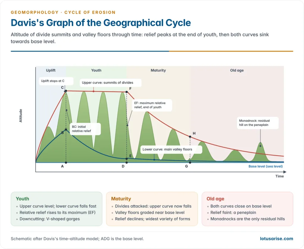
- Davis summarised the cycle in a time–altitude graph.
- Horizontal axis: time. Vertical axis: altitude above sea level.
- Upper curve (UC): summits of the water divides (absolute relief).
- Lower curve (LC): valley floors of the main streams.
- Relative (available) relief: the vertical gap between the two curves, i.e. the difference between the highest and lowest points.
- Base level (line ADG) stands for sea level, the lowest limit to which a river can cut its valley; no river erodes below it.
- AC marks maximum absolute relief at the end of uplift and BC the initial relative relief. Uplift stops at C, and erosion then begins.
- EF marks the maximum relative relief, reached at the close of youth.
Stages of the Cycle
Youthful Stage
- Upper curve stays level, lower curve falls fast, so relative relief increases until it peaks at the end of youth.
- Interfluves untouched: rivers are few, small and widely spaced, so the broad divides between them are hardly eroded.
- Stream lengthening: short consequent streams and tributaries extend headward.
- Valley deepening dominates, for four linked reasons:
- the channel gradient is steep;
- steep gradient raises velocity and kinetic energy;
- higher velocity raises transporting capacity;
- large, angular boulders then act as tools of incision, drilling potholes in the bed.
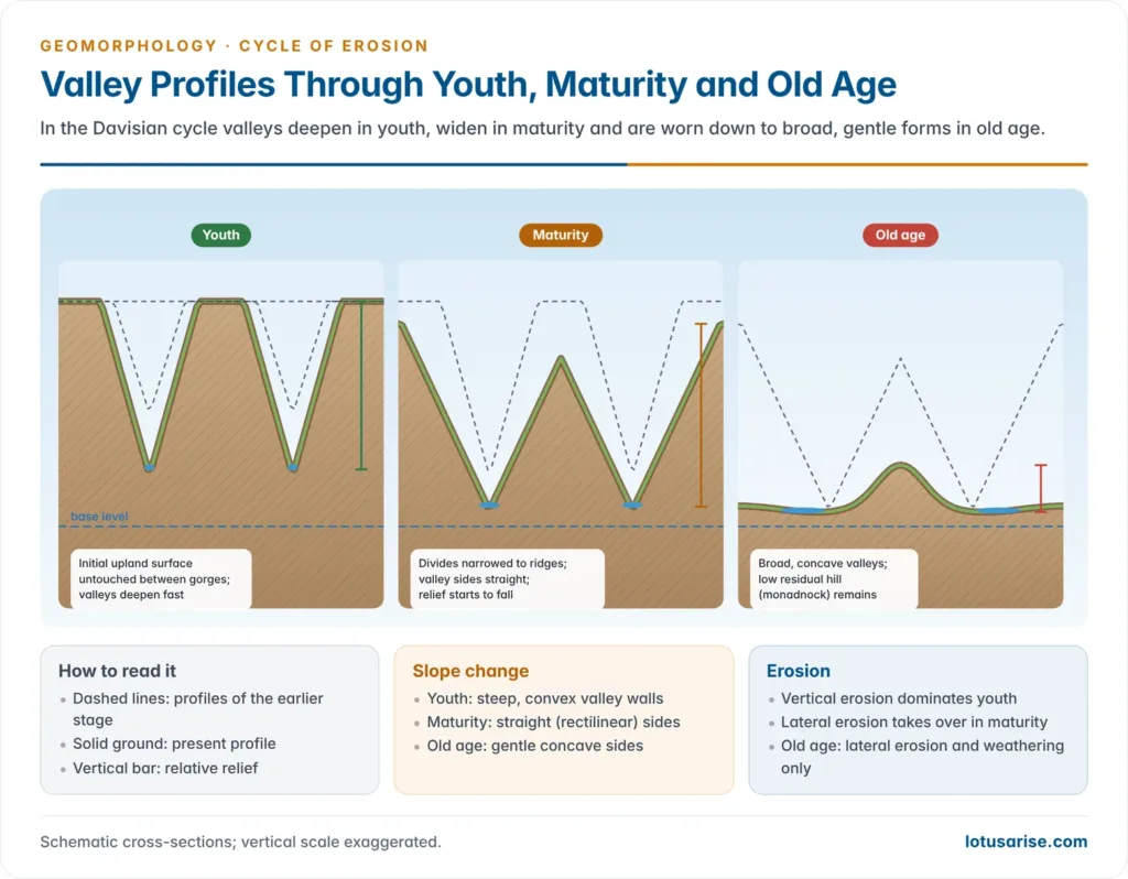
- Valley form: deep, narrow V-shaped valleys with convex sides; the overall form is a gorge or canyon.
- Long profile: broken by rapids and waterfalls, which retreat upstream and largely disappear by late youth, when the main river is graded.
- River capture is common, as vigorous headward-eroding streams seize the flow of weaker neighbours.
Mature Stage
- Lateral erosion takes over from downcutting; the drainage becomes well integrated.
- Grade spreads: most tributaries are now graded to base level, while valley deepening slows sharply because gradient, velocity and transporting capacity have all fallen.
- Divides are attacked: the upper curve now falls, so both absolute and relative relief decline.
- Valley form: V-shaped valleys widen into broad valleys with straight (rectilinear) sides.
- The greatest variety of landforms appears in this stage, with maximum integration of drainage.
Old Stage
- Valley incision almost ceases, but lateral erosion and valley widening continue.
- Divides are consumed from both sides by downwasting and backwasting, so the upper curve falls faster than the lower one and relative relief shrinks rapidly.
- Energy is at its lowest: channel gradient and kinetic energy are minimal, and entropy is at its maximum, i.e. relief is most uniformly spread.
- Valley form: almost flat valleys with gentle concave sides, wide floodplains and large meanders.
- The landscape becomes a peneplain: an undulating plain of very low relief broken only by residual convexo-concave hills (monadnocks).
- Old age lasts far longer than youth and maturity together, because erosion slows as gradient and relief fall.
| Feature | Youth | Maturity | Old age |
|---|---|---|---|
| Dominant erosion | Vertical (downcutting) | Lateral begins to dominate | Lateral only; weathering active |
| Absolute relief | Constant | Declines | Declines fastest |
| Relative relief | Rises to maximum | Declines | Very low |
| Valley shape | V-shaped gorge, convex sides | Wide, rectilinear sides | Broad, flat, concave sides |
| Long profile | Rapids and falls | Graded trunk and tributaries | Graded throughout |
| Interfluves | Broad, flat, uneroded | Narrow ridges | Low residual hills (monadnocks) |
Evaluation of the Davisian Model
Merits
- Simplicity and wide applicability: a single scheme that orders a vast variety of landforms.
- Style: lucid, persuasive prose, which helped the model win generations of readers; later geomorphologists such as Sheldon Judson (1975) still called Davis a “giant” of the field.
- Field basis: the model grew from careful observation, especially of the Appalachians.
- First general theory of landform development since Hutton’s cyclic Earth history.
- Synthesis: it absorbed John Wesley Powell’s base level, Grove Karl Gilbert’s graded stream and the French engineers’ profile of equilibrium.
- Durability: Charles G. Higgins (1975) observed that the very persistence of attacks on the model, by critics such as R. C. Flemal and C. R. Twidale, showed how strongly it still held the field.
- Explanatory power: it allows both prediction of future forms and historical interpretation (retrodiction) of past ones, and gave the basis for denudation chronology.
Criticism
- Uplift: Davis’s rapid, short-lived uplift conflicts with plate tectonics, which shows uplift to be slow and long-continued.
- Erosion waiting for uplift: erosion begins as soon as land rises.
- Davis in fact noted in 1899 that streams start incising while uplift is still under way; he left this out of the graph for simplicity.
- Crustal stability: an eventless span long enough to reach a peneplain is tectonically improbable, as plates are always in motion.
- Davis replied that where stability fails, the cycle is interrupted and a new one begins.
- Isostasy: as denudation unloads a landmass, isostatic rebound lifts it again, delaying or preventing the peneplain.
- Over-emphasis on time: Walther Penck argued that landforms reflect the rate of uplift relative to the rate of degradation, not their age, and wanted time (stage) dropped from the trio.
- Davis offered a time-dependent series of forms; Penck a time-independent one.
- Dynamic equilibrium: Strahler, Hack and Chorley rejected “historical evolution” in favour of landforms adjusted to present processes.
- Method: his account of process rested on observation and deduction, not instrumental measurement.
- Structure under-used: though structure is in the trio, he built no model of lithological adjustment of landforms.
- Oversimplification: real evolution is complex, non-linear and climate-sensitive; one sequence cannot fit every region.
- Peneplain questioned: few undisputed present-day examples exist at or near base level, and many “peneplains” have other origins.
- Deeper assumption: Higgins argued that the appeal of any cyclic, time-dependent model rests on an unstated belief that Earth history is itself cyclic; until that belief is examined, no non-cyclic theory can fully displace it.
Davis’s Concept of Grade
- Davis explained grade as a balance between the energy available and the work to be done (transport of load).
- In youth, available energy exceeds what is needed to carry the load, so the surplus is spent on downcutting.
- As valleys deepen, load rises and energy falls; when the two become equal the river is graded.
- Critics find two flaws:
- Erosion depends on sediment: a river cuts its bed chiefly with the load it carries, so erosion and transport cannot be separated as two budgets.
- Pure transport without erosion, with all energy spent on carrying load, practically never occurs.
Current View
- Process studies replaced the cycle as the research frame after about 1960, but it survives as a historical and teaching model and in denudation chronology.
- Not the whole story, but not wrong: Anthony Orme (2007) sees the cycle as one end-member in a range of possible histories of a landscape, fitting settings with short bursts of uplift followed by long quiet.
- Timescales: numerical river-incision models by Baldwin, Whipple and Tucker (2003) found that isostatic rebound, sediment-choked (transport-limited) rivers and erosion thresholds can keep residual relief for hundreds of millions of years after mountain building ends. This explains why old ranges such as the Appalachians and the Aravalli still stand, and why a true peneplain is rare.
- Rock control: cosmogenic-nuclide erosion rates from the tectonically quiet Quadrilátero Ferrífero of Brazil (Peifer and others, 2021) show quartzite ridges wearing down about ten times more slowly than granite lowlands, so relief can grow, not decline, without any uplift. Davis’s assumption of homogeneous structure is the weak link.
- Continuing use: the language of youth, maturity and old age, of base level and grade, and of polycyclic relief remains the working vocabulary for describing river valleys and old plateau surfaces, including India’s Peninsular uplands.
- Synthesis: modern landscape-evolution models treat uplift and erosion as simultaneous, as Penck argued, while keeping Davis’s insight that landforms carry inherited forms from earlier conditions.
Davis, Penck and King Compared
| Point | W. M. Davis (1899) | Walther Penck (1924) | L. C. King (1953) |
|---|---|---|---|
| Uplift | Rapid, short, then stability | Slow, varying rate, simultaneous with erosion | Episodic, with long stable spans |
| Key variable | Time (stage) | Ratio of uplift to erosion | Scarp retreat |
| Slope change | Slope decline | Slope replacement | Parallel retreat |
| End-form | Peneplain | Endrumpf (end-peneplain) | Pediplain |
| Setting | Humid temperate | Tectonically active | Arid and savanna Africa |
Normal Cycle of Erosion
Meaning
- The normal cycle of erosion is the cycle carried out by running water (fluvial processes).
- It is called “normal” because running water is the most widespread and most effective geomorphic agent on land, and still plays a role in glacial and arid regions.
- Davis took humid temperate lands as the normal case; this claim is debatable, since the humid tropics, savannas and drylands cover vast areas with different process regimes.
- Sequence:
- It begins with uplift of a landmass relative to sea level; rivers form on the new slope, and at first uplift outpaces erosion, so both absolute and relative relief rise.
- Uplift then stops, a long period of crustal stability follows, and erosion works on a still landmass.
- The land passes through youth (juvenile), maturity (equilibrium) and old age (senile), each split into early, middle and late sub-stages, and ends as a peneplain.
- Rivers pass through the same three stages, so a region is spoken of as having young, mature or old rivers as well as young, mature or old landscapes.
Youth
- In early youth, shallow lakes and swamps occupy hollows on the poorly drained, uneroded upland, and falls mark every resistant band crossed by the streams.
- Consequent streams form along the regional slope; they are few and short, with few tributaries. Rills and gullies dominate the slopes and lengthen by headward erosion.
- Tributaries grow from the master consequent streams, giving a dendritic drainage pattern.
- Pothole drilling is the most powerful process of downcutting; valley floors are studded with potholes.
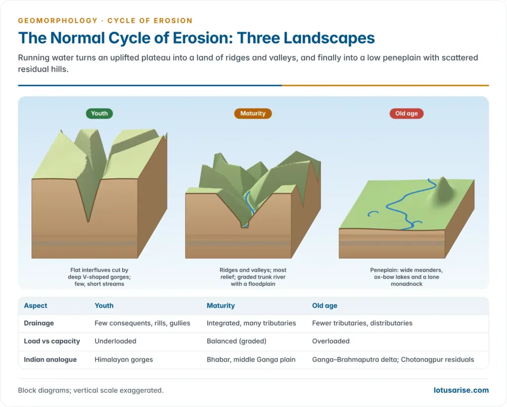
- Valleys are narrow and deep, with near-vertical convex walls: V-shaped gorges and canyons.
- Interfluves are wide and little eroded; the long profile carries rapids, waterfalls and knickpoints, most of which vanish by late youth.
- Rivers are underloaded: available energy exceeds the work to be done. River capture is typical.
- Indian example: the deep Himalayan gorges of the Indus, Sutlej and Siang (Brahmaputra) show youthful valley forms, though there they are kept young by continuing uplift rather than a single Davisian pulse.
Maturity
- Downcutting slows as gradient, velocity and transporting capacity fall; lateral erosion and valley widening dominate, and convex valley sides become uniform (rectilinear).
- At the mountain foot, the sudden drop in gradient makes rivers drop coarse load, building alluvial fans and cones that coalesce into piedmont plains.
- Indian example: the bhabar belt at the foot of the Siwaliks is such a coalesced fan surface.
- Interfluves are narrowed by backwasting into narrow ridges.
- The trunk river cuts down to base level and becomes graded: its long profile is a profile of equilibrium, with transporting capacity balanced against load.
- Low gradients produce meanders, wide floodplains, ox-bow lakes and natural levees, and rivers shift course often.
- Indian example: the middle Ganga plain, with its meander belts, ox-bow lakes and levees.
Old Age
- Gradient falls further; downcutting ceases; tributaries too are graded and fewer in number.
- Valleys become broad and flat with concave sides; weathering and lateral erosion lower the remaining divides by downwasting.
- Transporting capacity is at its minimum, so rivers are overloaded and deposition dominates.
- Rivers meander widely across floodplains sloping only a few degrees; near the mouth the channel splits into distributaries and builds a delta where conditions allow. The floodplain is bounded by bluffs, the valley-side slopes that mark the outer limit of floods.
- Indian example: the Ganga–Brahmaputra delta and the Sundarbans.
- The land becomes an undulating peneplain with scattered residual hills: monadnocks (after Mount Monadnock, New Hampshire, in the New England Appalachians), and larger residual masses termed unakas and mosores.
- Indian example: Parasnath hill rising above the worn surface of the Chotanagpur plateau is often cited as a monadnock.
- The peneplain has minimum potential and kinetic energy and maximum entropy.
| Aspect | Youth | Maturity | Old age |
|---|---|---|---|
| Drainage | Few consequents, rills, gullies | Integrated, many tributaries | Fewer tributaries, distributaries |
| Load vs capacity | Underloaded | Balanced (graded) | Overloaded |
| Typical landforms | Gorges, potholes, falls, capture | Fans, piedmont plains, meanders, ox-bows, levees | Wide floodplains, deltas, peneplain, monadnocks |
| Indian analogue | Himalayan gorges | Bhabar, middle Ganga plain | Ganga–Brahmaputra delta; Chotanagpur residuals |
Interruptions of the Cycle
Meaning and Causes
- The ideal cycle can complete itself only if the land stays still for a very long time, which the mobile crust rarely allows. Any break in its smooth running is an interruption of the cycle.
- Causes are tectonic, climatic or both:
- changes of sea level, through uplift or subsidence of ocean floors, or glaciation and deglaciation (the Carboniferous glaciation of Gondwanaland; the Pleistocene glaciation of the Northern Hemisphere);
- uplift or subsidence of the land;
- volcanic eruptions;
- climatic change.
- Eustatic example: during the last glacial maximum, about 20,000 years ago, sea level stood roughly 120 m below today’s, so rivers cut down towards a lower base level; the post-glacial rise then drowned their lower valleys and sent deposition inland.
- Davis himself separated interruptions (crustal movements) from accidents (changes of climate and volcanic eruptions, which strike arbitrarily in place and time).
Types of Interruption
| Type | Cause | Effect on the cycle | Example of outcome |
|---|---|---|---|
| Positive base-level change | Subsidence of land or rise of sea level | Cycle advances (shortened): youth to maturity, maturity to old age | Drowned valleys, rias, aggradation |
| Negative base-level change (rejuvenation) | Uplift of land or fall of sea level | Cycle pushed back (lengthened) to youth | Knickpoints, terraces, incised meanders |
| Climatic accident | Shift to arid or glacial climate | Agent changes; a different cycle takes over | Glacial troughs in once-fluvial valleys |
| Volcanic accident | Extensive lava flooding | Existing drainage erased; fresh cycle begins on the new surface | New drainage on a lava plateau |
- Base-level interruptions lengthen or shorten a running cycle; an accident closes the chapter and a new cycle starts after a gap.
- Indian example: the Deccan Traps lava floods buried older drainage, and the present Peninsular rivers began a fresh cycle on the basalt surface.
Rejuvenation and Polycyclic Landforms
- Rejuvenation is the renewed erosive vigour of rivers after a fall in base level (uplift of land or fall of sea level); the cycle is driven back to youth and valley deepening resumes.
- Landforms of rejuvenation: valley-in-valley (multi-storeyed) valleys, paired terraces, incised meanders, knickpoints and knickpoint waterfalls, uplifted peneplains, and gorges entrenched within broad, flat valleys.
- Relief built by several cycles, complete or incomplete, is polycyclic (multicyclic) relief.
- Chotanagpur plateau: stepped erosion surfaces, with falls such as Hundru on the Subarnarekha at the edge of the Ranchi surface.
- Damodar at Rajrappa (Ramgarh district, Jharkhand, at its confluence with the Bhairavi): incised meanders, terraces and valley-in-valley forms.
- Narmada at Bhedaghat near Jabalpur: the Dhuandhar falls, the marble gorge, incised meanders and paired terraces.
- The Appalachians of the USA are the classic foreign example.
Previous Year Questions
2023Define peneplains. Describe the landscape features associated with peneplains under different geomorphic cycles.2018“Landscape is a function of structure, process and stage.” Critique the statement.2013Differences between the normal cycle and the arid cycle of Davis.2012Characteristics of the standard epigene cycle of erosion.2008Critically examine the concept of geomorphic cycle and discuss the views of W.M. Davis and W. Penck.2002Provide a critique of the “geographical cycle” model, propounded by Davis.1994Discuss the concept of cycle of erosion and bring out clearly the difference between the views of Davis and Penck.1986Discuss the views of W.M Davis and Walter Penck on the cycle of erosion.





thank you sir
Useful notes
Great
i cannot understand the difference between davis cycle and normal cycle.. both seem same.. in both process of erosion is river.
Davisian model is a general model applicable to arid , fluvial etc
Davis initially developed his model in Humid areas with River as eroding agent – His fluvial model is regarded as Normal cyclone
Thank you sir