

- Karst topography is the landscape formed by the chemical solution of carbonate rocks, chiefly limestone and dolomite, by surface water and groundwater.
- Gypsum and rock salt also dissolve into karst-like forms, but true karst is a carbonate landscape.
- Its hallmarks are scarce surface drainage, underground drainage through sinkholes and caves, and a surface pitted with closed depressions.
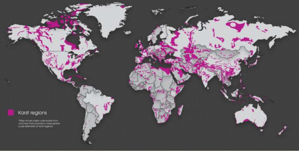
- Karstifiable carbonate rocks underlie about 15.2% of the Earth’s ice-free land, and some 1.18 billion people (16.5% of humanity) live on karst.
- Karst is the landform system of groundwater among the exogenic forces.
Groundwater and Solution: The Basis of Karst
Groundwater: Zones and Terms
- Groundwater is the water held in the pores and joints of the regolith and bedrock below the surface.
- Its source is infiltrating rainwater and meltwater; the water table rises after rains and falls in droughts.
| Term | Meaning |
|---|---|
| Aquifer | Permeable layer storing and yielding water (sands, sandstones, jointed limestone) |
| Saturated (phreatic) zone | All pores filled with water |
| Water table | Upper surface of the saturated zone |
| Vadose (aeration) zone | Above the water table; pores hold both air and water |
| Aquiclude | Impermeable bed that blocks flow between aquifers |
| Artesian aquifer | Aquifer confined between two aquicludes; water rises under pressure |
| Perched water table | Local water table held up by an aquiclude above the main one |
Geomorphic Work of Groundwater
- Groundwater moves very slowly, so abrasion, attrition and hydraulic action are negligible; corrosion (solution) is its only effective erosional process.
- It also lubricates slopes, aiding slumps and landslides.
- Slow water soon becomes saturated, so solution and deposition go hand in hand.
Chemistry of Limestone Solution
- Rainwater picks up atmospheric CO₂ and far more soil (organic) CO₂, becoming weak carbonic acid:
- CO₂ + H₂O ⇌ H₂CO₃ ⇌ H⁺ + HCO₃⁻
- CaCO₃ + H₂CO₃ ⇌ Ca(HCO₃)₂, calcium bicarbonate, which is soluble and carried away.
- The reactions are reversible: if water loses CO₂ or evaporates, calcite is re-precipitated, the basis of all karst deposition.
- Robert M. Garrels identified seven interacting variables: partial pressure of CO₂, H₂CO₃, HCO₃⁻, CO₃²⁻, H⁺, OH⁻ and Ca²⁺.
- Controls on the rate of solution:
- Partial pressure of CO₂, the dominant control.
- Temperature: cold water holds more CO₂, but warm humid climates have far more biogenic CO₂ and rain, so tropical karst is the most vigorous.
- Rock purity (limestone dissolves faster than dolomite), joint density, flow rate, contact time and flow route.
- Mixing corrosion, described by Alfred Bögli (1964): two saturated waters of different CO₂ content become aggressive again when they mix, explaining solution deep inside the rock.
Depositional Work
- Dissolved calcite is deposited when water entering an air-filled cave loses CO₂ to the cave air (the main cause), when water evaporates, or when flow is obstructed and slows.
- Deposits form on cave floors, cave ceilings and along rock joints.
Limestone, Dolomite and Chalk
- Limestone is a sedimentary rock of calcium carbonate, mostly of organic origin from shells and coral debris on the sea floor; dolomite is calcium–magnesium carbonate.
- Chalk is a pure, soft, white limestone but highly porous: water seeps through the whole mass instead of along joints, so chalk develops only feeble karst (dry valleys, a few swallow holes).
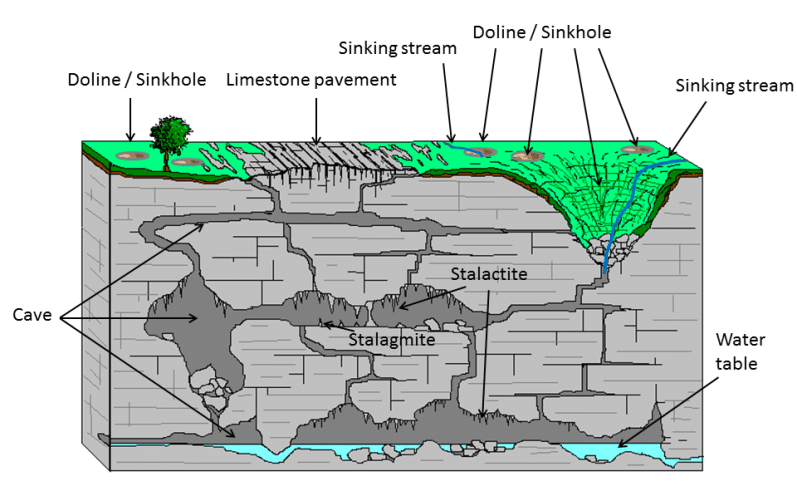
Karst Topography: Meaning, Conditions and Distribution
Meaning of the Term
- The name comes from the Kras (Karst) plateau on the Slovenia–Italy border, inland from Trieste.
- It is the north-western end of the Dinaric karst, a belt of folded limestone along the eastern Adriatic through the former Yugoslavia, rising to about 2,500 m and so cut by clefts and pits that it is almost impossible to cross on foot.
- Jovan Cvijić, in Das Karstphänomen (1893), first described karren, dolines and poljes systematically and is regarded as the father of karst geomorphology.
Essential Conditions for Karst Development
- Massive, thick-bedded, hard and well-jointed limestone, with a high density of joints to guide water.
- Low primary porosity, so permeability comes from joints, not the rock mass, and solution is concentrated along joints.
- Limestone above the water table, with deep valleys nearby, so surface drainage can sink and build caves.
- Wide extent of limestone, both in area and in depth, lying at or near the surface.
- Folding, faulting and fracturing, which open more paths for water.
- Moderate to heavy rainfall to supply the solvent.
Distribution
- World: the Dinaric karst; the Causses of southern France; Andalusia; western Cuba, Jamaica and Puerto Rico; the Yucatán Peninsula; Kentucky, Indiana, Tennessee and Florida (USA); and the South China Karst of Guangxi, Guizhou and Yunnan.
- Minor areas include Carlsbad (New Mexico), the Yorkshire Dales, the Burren (Ireland), the Jura and parts of the Alps.
- India: extensive karst is limited because most carbonate rocks lie buried.
- Vindhyan limestones are mostly covered by sandstones and shales; at Guptadham (Rohtas plateau, Bihar) the cave limestone lies under about 90 m of sandstone.
| Area | State | Features |
|---|---|---|
| Jaintia, Khasi and Garo hills | Meghalaya | India’s longest caves: Krem Liat Prah–Umim–Labit (more than 30 km), Mawmluh (about 7.2 km), Siju |
| Ananthagiri hills, Araku Valley | Andhra Pradesh | Borra Caves, cut by the Gosthani river, about 80 m deep |
| Kolimigundla, Nandyal district | Andhra Pradesh | Belum Caves, about 3.2 km, a plains cave entered through dolines |
| Kanger Valley National Park, Bastar | Chhattisgarh | Kotumsar Cave, with blind cave fish |
| Rohtas plateau | Bihar | Guptadham galleried cave |
| Chitrakoot, Satna district | Madhya Pradesh | Gupt Godavari caves |
| Dehradun (Sahasradhara, Tapkeshwar, Robber’s Cave) | Uttarakhand | Dripping calcareous springs and small caves |
| Jammu & Kashmir, eastern Himalaya | Himalayan states | Himalayan limestone karst |
Characteristics of Karst Regions
- A bleak, rugged surface broken by steep slopes, pits and clefts.
- Near absence of surface drainage: most rain sinks, so surface valleys are dry.
- Streams work down joints and fissures into a network of underground channels.
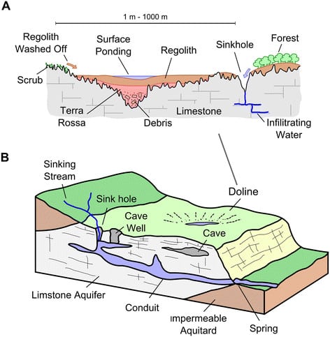
- Where water meets an impermeable bed at the base of the limestone, it re-emerges as a spring or resurgence.
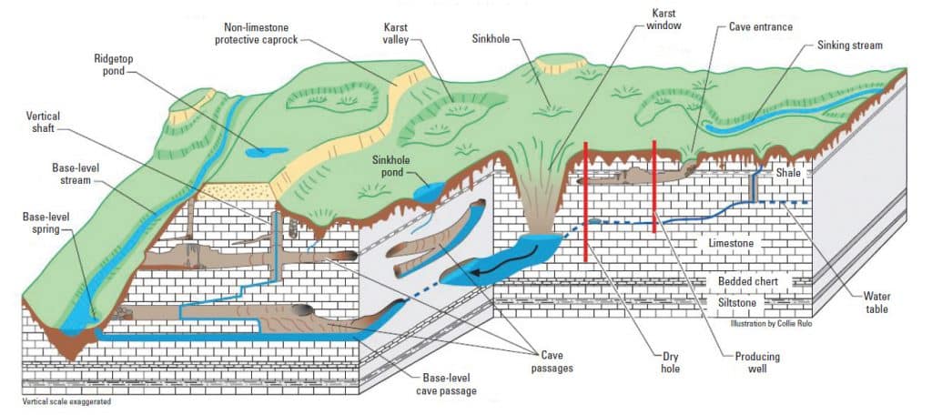
Erosional Landforms of Karst
Surface Solution Forms
- Lapies (French) is the fretted, fluted surface of exposed limestone: rills, clefts and sharp ridges formed by solution along joints.
- Regional names: karren (Germany), clints and grikes (northern England), bogaz for large corridor-like clefts (Dinaric region).
- Limestone pavement is a flat, bare expanse of clints (isolated rectangular blocks) separated by grikes (joints widened by solution).
- Most were scoured bare by Pleistocene ice and then etched by solution, as at Malham (Yorkshire) and the Burren.
- Pinnacles are vertical rock blades sharpened by solution, as in the stone forests of Yunnan.
- The insoluble residue of solution is a red clayey soil, terra rossa.
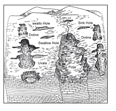
Solution Depressions: Sinkhole to Polje
| Form | Size | Origin | Key features |
|---|---|---|---|
| Sinkhole | Usually 3–10 m deep | Solution at joint intersections | Funnel-shaped or cylindrical |
| Swallow hole | Larger | Coalescence of sinkholes | Surface streams disappear through it |
| Doline | A few m to about 1 km across, up to about 300 m deep | Solution, or collapse of a cave roof | Basic closed depression of karst |
| Uvala | Up to about 1 km or more | Coalescence of dolines, or collapse of large cavities | Compound sink, steep sides, uneven floor |
| Polje | Several km² to over 400 km² | Tectonic basin modified by solution | Flat alluvial floor, steep walls, seasonal lakes |
Sinkholes, Swallow Holes and Dolines
- Sinkholes are the smallest closed depressions; as they widen and merge they form swallow holes, through which surface streams vanish.
- Local names: cenotes (water-filled collapse sinks of the Yucatán), blue holes (drowned sinks, such as the Great Blue Hole of Belize), sótanos (deep shafts, Mexico), tomo (New Zealand).
- Dolines (dolinas in Serbia) are enlarged swallow holes: solution dolines form by surface solution, collapse dolines when a cave roof gives way.
- Shallow but broad dolines are solution pans; steep rock-walled collapse hollows are cockpits (Jamaica).
- Karst lakes form when a doline or larger basin is sealed by clay; many fill after heavy rain and drain again.
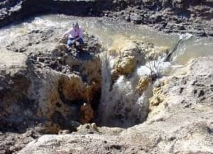
Karst Windows
- A karst window forms when the roof over an underground stream collapses: the stream emerges at one end of the opening and vanishes at the other.
- Adjoining collapse sinks can merge into a broad window.
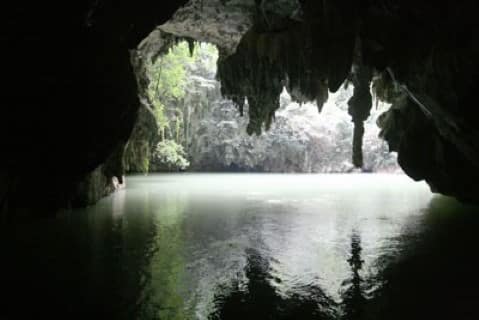
Uvalas and Poljes
- Uvalas are compound sinks formed by the coalescence of several dolines or sinkholes, or by collapse of large cavities.
- Steep-sided, generally dry, with clay floors; elongated ones follow joint trends; small ones are jamas.
- Clyde A. Malott called the larger ones karst windows.
- Poljes are the largest karst depressions: elongated, flat-floored closed basins with steep walls, alluvial floors and often a seasonal lake.
- Floor streams sink through ponors at the margin; the Livanjsko polje (Bosnia and Herzegovina), over 400 km², is the largest known.
- Most are downfaulted or downfolded basins modified by solution; B. W. Sparks (1972) regarded them as tectonic depressions rather than true solution forms.
Karst Valleys and Disappearing Streams
- A gently dipping limestone surface pitted with sinkholes is a karst plain; its valleys all relate to sinks.
- Sinking creek: a stream that loses water progressively through a line of sinks in its bed.
- Blind valley: a valley that ends abruptly downstream where its stream vanishes into a swallow hole; O. D. von Engeln noted they develop on uvala floors.
- Steephead (pocket) valley: the reverse form, a valley that begins abruptly at a cliff foot where an underground stream resurges.
- Karst (solution) valley: a broad U-shaped valley that holds a stream only temporarily; dry valleys remain once drainage goes underground.
Caves and Caverns
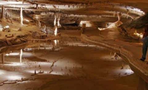
- Caves are large underground voids, the most significant erosional landform of groundwater, formed mainly by solution and partly by abrasion; the largest form in pure, massive, thick-bedded limestone.
- Mammoth Cave (Kentucky), with over 686 km of surveyed passages, is the world’s longest known cave system; the Big Room of Carlsbad Caverns is about 1,220 m long.
- Guptadham is a galleried cave: horizontal passages with amphitheatre-like halls where tunnels cross.
- Ponors (Serbia) or avens (France) are vertical or inclined shafts joining swallow holes to caves.
Theories of Cave Origin
| Theory | Proponent (year) | Zone of formation | Core idea |
|---|---|---|---|
| Corrasion (vadose) | Édouard-Alfred Martel and others | Vadose, above water table | Free-flowing streams abrade and dissolve passages |
| Two-cycle | William Morris Davis (1930) | Deep phreatic, then vadose | Solution under hydrostatic pressure; uplift drains the cave and speleothems grow |
| Water table | Allyn C. Swinnerton (1932) | At the water table | Lateral flow at the water table dissolves passages |
| Static water zone | J. H. Gardner (1935) | Above a static water zone | Deepening valleys drain the static zone; vadose water enlarges caves |
| Invasion | Clyde A. Malott | Vadose | Surface streams enter through sinks and enlarge passages |
- The theories differ on where caves form relative to the water table.
- J Harlen Bretz (1942) supported Davis with phreatic features such as ceiling pockets; B. C. Moneymaker (1941) held that caves begin below the water table but grow above it.
- Current view:
- Derek Ford and R. O. Ewers (1978) reconciled the theories in a four-state model: where fissures are few, water follows deep phreatic loops; where they are many, caves form at the water table. Multi-level caves record successive falls of base level.
- About 90% of caves are epigenic, dissolved by meteoric water from above; a minority are hypogene, dissolved from below by sulphuric acid from rising hydrogen sulphide, as at Carlsbad and Lechuguilla.
Natural Bridges
- Natural bridges form when part of a cave roof collapses, leaving an arch, or when a stream sinks and resurges, leaving the rock between as a bridge.
- Explanations include solution (F. W. Gilmer), subterranean stream piracy (H. P. Woodward) and subterranean cut-off (Malott and R. R. Shrock).
Tropical and Temperate Karst
| Type | Climate | Landforms | Example |
|---|---|---|---|
| Doline karst | Humid temperate | Dolines, uvalas, lapies, caves | Dinaric karst, Causses |
| Cockpit (cone) karst | Humid tropical | Star-shaped cockpits between cone hills | Jamaica |
| Tower karst | Humid tropical | Steep isolated towers above alluvial plains | Guilin (Guangxi), Viñales (Cuba), Ha Long Bay |
| Fluviokarst | Mixed | River valleys with sinks and dry valleys | Kentucky |
- Climate changes the karst assemblage as much as time does.
- Cockpit to cone and tower karst: in the humid tropics closely spaced dolines widen fast into star-shaped cockpits; as neighbouring cockpits coalesce, the ridges between them are reduced to conical hills (cone karst).
- Taller, steeper, often isolated residual hills are tower karst; the Chinese terms fengcong (peak cluster, cones on a common rock base) and fenglin (peak forest, towers rising from a karst plain) carry the genetic sense, and much fenglin evolves from fengcong where uplift is slow.
- Polygonal karst: a surface completely pitted by closely packed dolines or cockpits, so that the divides between them form a polygonal, honeycomb-like network.
- Analysed by Paul W. Williams (1972) in New Guinea; also well developed in New Zealand and southern China.
- Climatic significance: classically, cone and tower karst were treated as humid-tropical forms, so those found in extratropical lands such as Poland and New Zealand were read as relict (palaeo) landforms of warmer past climates.
- George A. Brook and Derek C. Ford (1978), working on the labyrinth and tower karst of Nahanni (Canada), showed that tower karst is polygenetic and not confined to the humid tropics; jointing, structure and time matter as well as climate.
Depositional Landforms of Karst
Speleothems
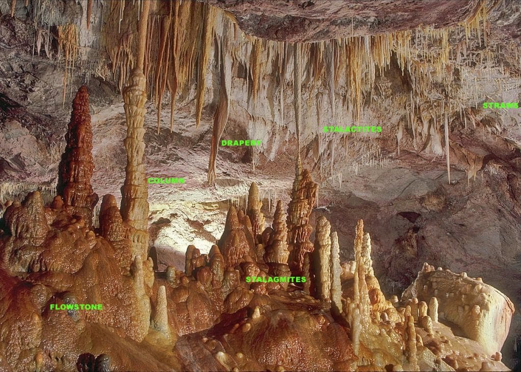
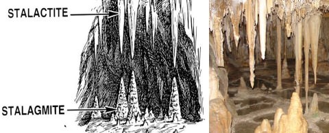
- Speleothems are calcite deposits formed inside caves, precipitated mainly as dripping water degasses CO₂ into cave air during the dry (vadose) phase of a cave.
- Level or evenly arched ceilings give straight stalactites; inclined ceilings give inclined, elongated ones.
| Form | Where it grows | Shape and origin |
|---|---|---|
| Stalactite | Hangs from the ceiling | Icicle-like, broad base, tapering tip |
| Stalagmite | Rises from the floor | Shorter, stouter, rounded; compound when adjacent centres merge |
| Cave pillar | Floor to ceiling | Stalactite and stalagmite joined |
| Helictite / heligmite | Sideways from stalactites / stalagmites | Twisted, growing against gravity; globular ones are globulites |
| Drapes (curtains) | Along ceilings | Sheets or rows of needle-like dripstone |
| Flowstone | Floors and walls | Sheets from seeping and flowing water |
- Dripstone is the general name for calcite deposited from dripping water.
- Stalagmites are layered like tree rings and serve as climate archives: a Mawmluh Cave stalagmite defines the base of the Meghalayan Age (from 4,200 years ago), ratified by the International Commission on Stratigraphy in 2018.
Tufa, Travertine and Terra Rossa
- Tufa (calc-tufa) is soft, porous carbonate precipitated from cool water at springs, streams and cave mouths, often around mosses.
- Travertine is denser and banded, usually precipitated from hot springs.
- Terra rossa is the reddish, clayey residual soil of limestone areas, rich in iron oxides, well drained and near-neutral in pH.
Karst Cycle of Erosion
The Concept
- The cycle idea was applied to limestone by J. W. Beede (1911), with three stages, and by Jovan Cvijić (1918), with four (youth, maturity, late maturity, old age).
- William Morris Davis (1930) treated it as a special phase of the normal cycle: surface drainage, its disappearance underground, and its reappearance.
- It is simpler than other cycles because of uniform structure and a single dominant process, solution.
- Its difficulty is the base level, usually taken as the water table or the underlying impermeable bed.
- It starts on thick limestone exposed at the surface, or under a thin insoluble cover that runoff first strips, and works best on folded or faulted limestone.
| Stage | Drainage | Landforms |
|---|---|---|
| Youth | Surface streams begin to sink | Lapies, sinkholes, swallow holes, dolines, blind valleys, sinking creeks, small caves |
| Early maturity | Entirely underground; surface dry | Caves enlarge; roofs thin and collapse into uvalas, poljes, karst windows |
| Late maturity | Underground, reaching the impermeable base | Most solution forms destroyed; pitted ridges between uvalas narrow |
| Old age | Surface streams reappear on the impermeable base | Low residual hills (hums) on a karst plain resembling a peneplain |
- Renewed uplift of the karst plain can start a second cycle.
Evaluation
- Merit: it explains the sequence from surface to underground to surface drainage and the growth of depressions from sinkholes to poljes.
- Limitations:
- The base level in karst is uncertain and shifting.
- Climate, not stage, largely decides whether a region has doline karst or tower and cone karst.
- Tectonic poljes, glaciated pavements and buried karst such as Guptadham do not fit a single sequence.
- Modern work treats karst as an open process-response system of rock, water and CO₂ rather than a fixed sequence.
Human Use and Hazards of Karst Regions
- Karst uplands are often barren, with thin soil and poor grass; tropical karst carries luxuriant forest under heavy rain.
- Karst aquifers meet roughly a quarter of global drinking-water demand, but fast conduit flow gives little filtration, so they are highly vulnerable to pollution.
- Sinkhole collapse threatens roads and buildings, as in Florida.
- Limestone is quarried as building stone and for cement and lime; some carbonate rocks host lead–zinc ores.
- Borra, Belum and the Meghalaya caves draw tourists; Mawmluh was listed in 2022 among the IUGS’s first 100 geological heritage sites.
Previous Year Questions
2022Define ‘speleothem’. Discuss the various forms and features of speleothems.2010Write short note on Essential conditions for the development of Karst topography.1991Analyse the sequential development of landforms in either Karst or Coastal region.1988Write short note on Karst landforms in about 200 words.





Thanks for valuable notes sir
Very nice content
Though Lotusarise has put amazing efforts to create the above content but UPSC 2022 has asked about “Speleothems” which is part of karst landforms (depositional landforms). Titled in the Savindra Singh: Geomorphology (Page no 443). The conclusion is, though you read all notes, PYQs… UPSC will definitely ask one or two question what exactly you missed out 😂. By the way kudos to the efforts of Lotus Arise👍🏻👍🏻
it(Speleothems) is also mentioned in these notes.. read carefully.
Thanks for providing such organized material for geography Optional.
Ncert me kuch sthaniy karst pradesh ke name puchha hai
Kya aap ise similar kr skte hai?
Useful content sir