

- Lester Charles King (1907–1989), a geomorphologist at the University of Natal, Durban, built a complete system of landscape evolution from the arid, semi-arid and savanna landscapes of southern Africa.
- His system links a hillslope cycle, a river cycle and a landscape cycle, all resting on one mechanism: parallel retreat of scarps.
- The core of the system is the cycle of pediplanation: slopes retreat parallel to themselves, leave pediments at their foot, and the pediments merge into a pediplain.
- The pediplain concept first appeared in South African Scenery (1942), was codified as the “Canons of Landscape Evolution” (1953) and extended to all continents in The Morphology of the Earth (1962).
- King offered it as the main alternative to the Davisian geographical cycle, holding that landscapes are worn back by backwasting, not worn down by downwasting.
Foundations of King’s Model
Sources of the Model
- King called his system new, but it is a synthesis of earlier ideas with his own African field observation; in its overall frame it stands closer to Davis than to Penck.
| Borrowed from | Idea taken over | How King used it |
|---|---|---|
| William Morris Davis (1899) | Short, rapid uplift followed by long stillstand; youth–maturity–old age | Kept the cyclic frame and the three stages |
| Walther Penck (1924) | Slopes retreat parallel to themselves; piedmont steps | Made parallel retreat universal; staircases of pediplains |
| Alan Wood (1942) | Four hillslope elements: waxing slope, free face, debris slope, waning slope | Adopted the four elements as the “standard” hillslope |
| T. J. D. Fair (1947–48) | Scarp retreat and pediments on Natal slopes | Local field support for backwasting |
| Robert E. Horton (1945) | Overland flow and sheetwash on slopes | Sheetwash as the agent grading pediments |
| King’s own work | Pediments, inselbergs, scarps across Africa | Pedimentation + scarp retreat = pediplanation |
Assumptions
- Semi-arid and savanna landscapes are “normal”, not the humid temperate lands on which Davis built his model.
- Humid mid-latitude landscapes were remodelled by Pleistocene glaciation and carry many relict periglacial forms, so they cannot serve as the standard.
- For King, subtropical semi-humid regions were the most normal setting for landscape evolution.
- Uniformity across climates: the basic physical controls of landscape are the same in all climates except the frigid and the extremely arid (King, 1957).
- This openly rejects the core claim of climatic geomorphology that slope form changes with climatic type.
- Tectonic rhythm: each cycle begins with rapid, episodic uplift followed by a long period of crustal stability, and major uplifts are continent-wide and rhythmic.
- A new cycle starts from the uplift of an older pediplain, not of a fresh structural block.
- Climatic change has little effect on landforms shaped by running water.
- Running water and mass movement are the main agents, and slopes always retreat parallel where relief and rock strength allow.
- Denudation has two phases: production of rock waste by weathering and removal of that waste downslope.
King’s Hillslope Model
Elements of the Standard Hillslope
- King accepted Wood’s four elements as the standard (fully developed) hillslope, the product of normal slope evolution by flowing water and mass movement.
| Element | Form | Dominant process | Behaviour over time |
|---|---|---|---|
| Waxing slope (summital convexity) | Convex crest of hill or scarp | Soil creep | Stays constant; supply of waste balances its removal |
| Free face (scarp) | Bare bedrock outcrop, steep | Rockfall, landslides, gullying | Most active element; retreats parallel and drives the whole slope |
| Debris slope (constant or rectilinear slope) | Straight slope at the angle of repose of the talus | Fall and slide of debris from the face | Does not grow upslope, so it never buries the free face |
| Pediment (waning slope) | Broad concave ramp cut in rock, with a thin veneer of debris | Sheetwash and sheet floods | Extends upslope as the elements above it retreat |
- Each element evolves semi-independently yet reacts on the others.
- King held that these four elements occur on hillslopes in every climate; where one is missing locally, the departure does not disprove the norm of full development.
- Full development needs two conditions: resistant, strong bedrock and bold, adequate relief.
- Without them the free face disappears first, then the debris slope, leaving a waning convexo-concave slope that evolves by slope decline.
- On this basis King treated the widespread convexo-concave slopes of the temperate northern hemisphere as relict periglacial forms on weak rocks, not as products of present processes.
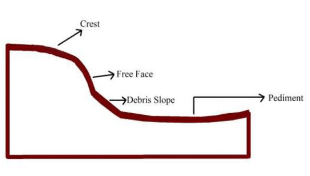
Mechanism of Parallel Retreat
- Backwasting of the free face controls the evolution of the whole hillslope.
- Weathering of exposed rock makes the scarp retreat without losing steepness; scarps keep angles of about 15° to 30°.
- King called this scarp retreat.
- Balance on the upper elements: waste reaching the crest and the debris slope is removed as fast as it arrives, so both keep a constant form while moving back.
- Growth of the pediment: as the free face and debris slope retreat, the pediment lengthens upslope at their expense.
- King regarded the pediment as the fundamental landform to which all landscapes shaped by running water tend to be reduced; its making is pedimentation.
- End of the hillslope cycle: the free face and debris slope are consumed, pediments from opposite sides meet at the crest, and an extensive concave erosion surface, the pediplain, results.
Cycle of Pediplanation
Elements of the Landscape
- King saw the African landscape as built of three elements:
- Rock pediments flanking valleys, concave in profile and gentle, from about 1.5° to 7°.
- Scarps bounding the uplands at 15° to 30°, retreating parallel by weathering and rainwash.
- Inselbergs: steep-sided residual hills rising abruptly from the plains.
- Bornhardts are dome-shaped, bare-rock inselbergs; castle koppies are piles of joint-bounded boulders left when inselbergs decay.
- Size depends on the amount of erosion; shape depends on structure and jointing, so flat-topped mesas and buttes form where a hard caprock is present.
- The cycle runs on twin processes: scarp retreat and pedimentation.
Stages of the Cycle
| Stage | River action | Slopes and scarps | Landforms | Relief |
|---|---|---|---|---|
| Youth | Rapid downcutting after uplift; knickpoints migrate upstream | Steep valley sides at constant angles | Gorges, canyons; small pediments in valley bottoms by late youth | Increases |
| Maturity | Downcutting ends; lateral erosion widens valleys | Scarps retreat without flattening | Wide pediments (about 5°–10°); inselbergs fewer, many reduced to castle koppies | Constant or declining |
| Old age | Rivers wander across low gradients | Scarps almost consumed | Multi-concave pediplain with a few residual hills | Minimum |
- Youth: the cycle opens with uplift of an earlier pediplain.
- Rivers incise rapidly; knickpoints mark the long profiles and move upstream.
- As incision slows, small pediments appear in valley floors and widen by scarp retreat.
- By late youth most interfluves are narrowed into inselbergs, many rounded into bornhardts.
- Maturity: lateral erosion replaces deepening, so valley sides move away from the channel while keeping their angle.
- Weathering steadily reduces the number and size of inselbergs.
- Pediments of neighbouring valleys coalesce into a low, uneven plain of intersecting concave surfaces, still studded with remnant hills.
- Old age: almost all residual hills are gone and the landscape is dominated by low-angle pediments.
- The multi-concave pediplain is the ultimate form of the cycle.
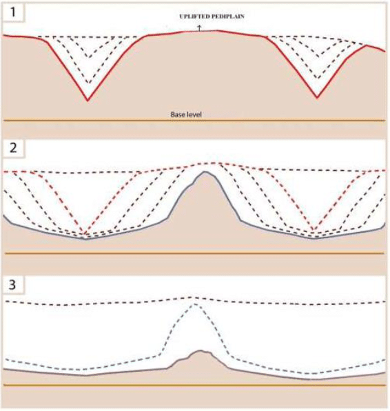
Headward Growth and Antique Pediplains
- A pediplain, once formed, keeps growing headward.
- Renewed uplift starts a new scarp at the outer edge of the old surface; its retreat consumes the older pediplain and leaves a younger, lower pediplain behind it.
- Repeated cycles build a staircase of intersecting pediplains, much like the piedmont steps of the Penck model.
- Antique pediplanation: because scarps retreat rather than wear down, very old surfaces can survive on summits, especially on resistant rocks.
- King placed his highest remnants before the break-up of Gondwana and correlated surfaces across Africa, South America and Australia.
| King’s surface | King’s age | Relative position |
|---|---|---|
| Gondwana | Jurassic | Highest summit remnants, older than continental break-up |
| Post-Gondwana | Cretaceous | Below the Gondwana remnants |
| African | Late Cretaceous to mid-Tertiary | Most extensive surface of the continent |
| Post-African I | Miocene | Cut below the African surface |
| Post-African II | Pliocene | Lowest and youngest |
- T. C. Partridge and R. R. Maud (1987) revised this scheme for southern Africa into an African surface (Late Jurassic/Early Cretaceous to early Miocene), a Post-African I surface and a Post-African II surface.
Evaluation
King, Davis and Penck Compared
- Common ground with Davis: episodic uplift then long stability; all three stages completed; a final surface that is old, extensive and of subdued relief.
| Basis | Davis | Penck | King |
|---|---|---|---|
| Tectonics | Rapid uplift, then stillstand | Continuous, varying uplift | Rapid episodic uplift, then stillstand |
| Slope process | Downwasting; slope decline | Slope replacement from below | Backwasting; parallel retreat |
| “Normal” climate | Humid temperate | No climatic norm | Semi-arid and savanna |
| Final surface | Peneplain (convexo-concave) | Endrumpf | Pediplain (multi-concave) |
| After formation | Static until re-uplift | Evolves with uplift rate | Keeps growing headward |
| Residual hills | Monadnocks | Inselbergs | Inselbergs, bornhardts, castle koppies |
Criticism
- Generalised from one region: a model built in Africa was extended to lands with very different climates, and the claim of uniform development in all environments is doubtful.
- Reconnaissance, not measurement: Anthony Young (1972) noted that King’s work contains no measurement of process or form.
- Evidence was chosen to fit preconceived views, and contrary cases were set aside as “not normal”.
- His hydraulic argument, that turbulent flow on the upper slope gives way to laminar sheet flow on the pediment, was never tested experimentally.
- The model is best read as a set of hypotheses for testing, not proven laws.
- Largely deductive: much of the hillslope model repackages Wood, Fair, Penck and Horton.
- Antique pediplains are questionable because of the enormous time spans involved and poor knowledge of erosion rates in subhumid lands.
- Structure underplayed: King downgraded the control of rock type and jointing on landforms.
- Parallel retreat is not universal: R. A. Savigear (1952) showed on the coast of South Wales that parallel retreat and slope decline can operate side by side, depending on whether debris is removed from the slope foot.
- Timing: the “Canons” appeared just as geomorphology turned to quantitative process studies at small scales, so broad cyclic theory drew little attention.
Current View
- C. R. Twidale (2003), reviewing the “Canons” fifty years on, found scarp recession and the great age of some surfaces still valid, and King’s continent-scale outlook ahead of its time.
- What has not survived is his downgrading of structure and his necessary link between scarp retreat and pedimentation; pediments can form without retreating scarps.
- Etch (two-stage) origin: many inselbergs and planation surfaces are now explained by deep weathering below the surface followed by stripping of the weathered mantle, an idea going back to John Downie Falconer (1911) and developed by Julius Büdel as the etchplain.
- Dating evidence: thermochronology and cosmogenic nuclides show that southern Africa’s Great Escarpment retreated fast soon after Gondwana break-up and has since been nearly stable.
- Present denudation is slow, around 5 m per million years in south-central South Africa, and pediment surfaces erode far more slowly (Paul Bierman and colleagues, 2014).
- This supports King’s point that old surfaces can survive, but not a steady, continuous scarp retreat.
- Kevin Burke and Yanni Gunnell (2008) reinterpret King’s separate African surfaces as one composite erosion surface made largely of etchplains, formed about 70–40 million years ago, whose different heights reflect later continental warping, not separate cycles.
- Legacy: King made planation surfaces, escarpments and inselbergs central to geomorphology, backed continental drift early, and gave passive-margin escarpments a framework still used.
Relevance to Peninsular India
- Vindhyan scarps: the Kaimur range, Rohtas plateau, Rewa plateau and Bhander plateau show bold escarpments of massive, well-jointed sandstone over shales and siltstones.
- These scarps show all four slope elements; the sandstone free face retreats parallel by physical and chemical weathering, and detached sandstone-capped hills stand as mesas and buttes (Satna district, Madhya Pradesh).
- Where the sandstone cap has been removed, nearby hills turn to slope decline and convexo-concave forms, showing that both mechanisms operate side by side.
- Chotanagpur plateau: stepped surfaces, from the high pat lands to the Ranchi surface and lower plains, are separated by scarps with waterfalls such as Hundru and Dasam, a staircase read as successive planation cycles.
- The granite-gneiss inselbergs and boulder tors around Ranchi (such as the Pithoria hills) resemble King’s bornhardts and castle koppies.
- Other residual landscapes: granite inselbergs and boulder hills of Bundelkhand and the Hampi area of Karnataka; rock pediments fringing the Aravalli hills in arid Rajasthan.
- Western Ghats: a rift-margin great escarpment like South Africa’s, whose landward retreat after India separated from Madagascar and the Seychelles is the kind of long-term scarp recession King described.
Previous Year Questions
2016“In explaining the concept of ‘Pediplanation’, King combined the ideas of Davis, Penck and Wood with his own.” Elaborate.2009Discuss views on slope development provided by L.C. King.





Very good notes , is this notes specifically created by you..? Any source coaching or book used for these notes ?.
Your explanation on Kings theory leans so much on Davis cycle of erosion to the effect that differences between the two theories are not clear