

- An erosion surface (planation surface) is a near-level to gently undulating land surface of low relief, produced by long-continued denudation, that cuts across rocks of different hardness and across geological structures alike.
- It is the end product or near-end product of a complete or incomplete cycle of erosion by running water, wind, waves, ice or weathering in a given climate.
- Peneplains, pediplains, panplains, etchplains, panfans, plains of marine erosion and cryoplains are all erosion surfaces in this restricted sense: flat or near-flat plains formed close to base level, after erosion has passed well beyond youth.
- Erosion surfaces are the building blocks of denudation chronology: their fragments, now uplifted, tilted or buried, record the past base levels, climates and tectonic history of a landscape.
Meaning and Types of Erosion Surfaces
Erosion Surface versus Structural Surface
- The term planation was introduced by Grove Karl Gilbert (1877) in his Henry Mountains report, for the carrying away of rock to produce an even surface, which rivers at the same time veneer with a thin alluvial cover.
- A structural surface is controlled by rock structure: where a weak horizontal bed overlies a resistant one, the weak bed is stripped and the land surface follows the top of the resistant bed and its dip.
- An erosion surface is indifferent to structure: it bevels soft and hard rocks, folds, faults and uniclinal beds at one common level.
- Strictly, every land surface that is not depositional is a surface of erosion (even the dip and scarp slopes of a cuesta), but the term is reserved for extensive plains of denudation near base level.
| Basis | Structural surface | Erosion (planation) surface |
|---|---|---|
| Control | Rock structure and dip | Denudation to a base level |
| Relation to strata | Parallel to a resistant bed | Cuts across beds and structures |
| Rock types | One resistant bed exposed | Hard and soft rocks bevelled alike |
| Example | Stripped plateau on a resistant sandstone | Central Ranchi plateau surface |
Types of Erosion Surfaces
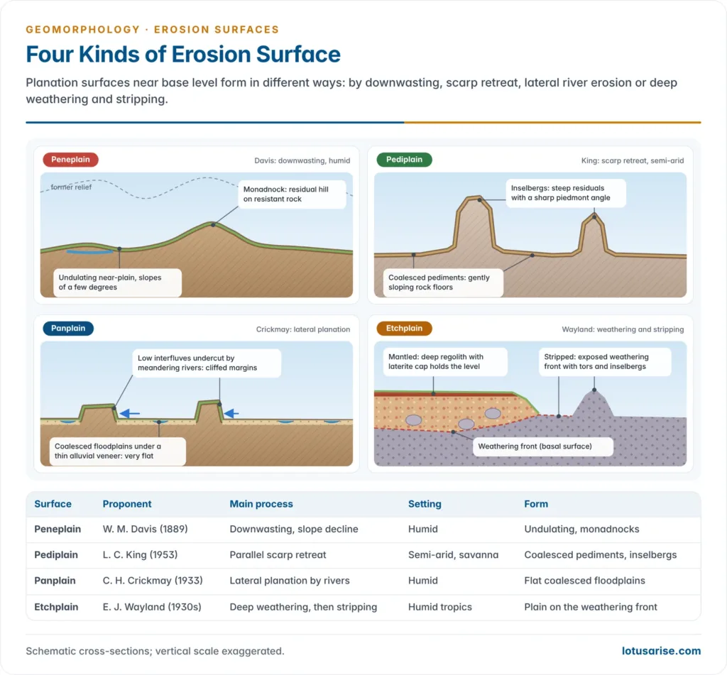
- Major surfaces are named after the process and the scholar who proposed them:
| Surface | Proponent | Main process | Climate / setting | Form |
|---|---|---|---|---|
| Peneplain | William Morris Davis (1889) | Downwasting, slope decline | Humid | Undulating, with monadnocks |
| Primärrumpf / Endrumpf | Walther Penck (1924) | Slope replacement with uplift | Any, tectonically active | Low concave slopes |
| Pediplain | Lester Charles King (1953) | Parallel scarp retreat, pediments | Semi-arid, savanna | Coalesced pediments, inselbergs |
| Panplain | Colin Hayter Crickmay (1933) | Lateral planation by rivers | Humid | Flat coalesced floodplains |
| Etchplain | Edward James Wayland (early 1930s) | Deep chemical weathering, stripping | Humid tropics | Plain on weathering front |
| Panfan | Andrew Cowper Lawson (1915) | Coalescing fans and pediments | Arid | Desert plain at end stage |
| Cryoplain | Periglacial workers | Frost action, solifluction | Periglacial | Altiplanation terraces |
| Marine plain | Andrew Crombie Ramsay (1846) | Wave abrasion | Coasts | Platform bevelled by the sea |
- German summit-level terms describe related ideas:
- Gipfelflur (summit level): the accordant level of mountain peaks, used by Albrecht Penck (1919) for the Alps.
- Piedmonttreppe (piedmont benchland): a staircase of surfaces produced, in Walther Penck’s view, by waxing uplift of a growing dome.
- Minor erosion surfaces: valley-side benches, river terraces, marine benches (platforms), marine flats and terraces, and raised beaches.
- Cryoplanation and altiplanation terraces are cut by frost action and solifluction in periglacial settings.
Peneplains
Evolution of the Concept
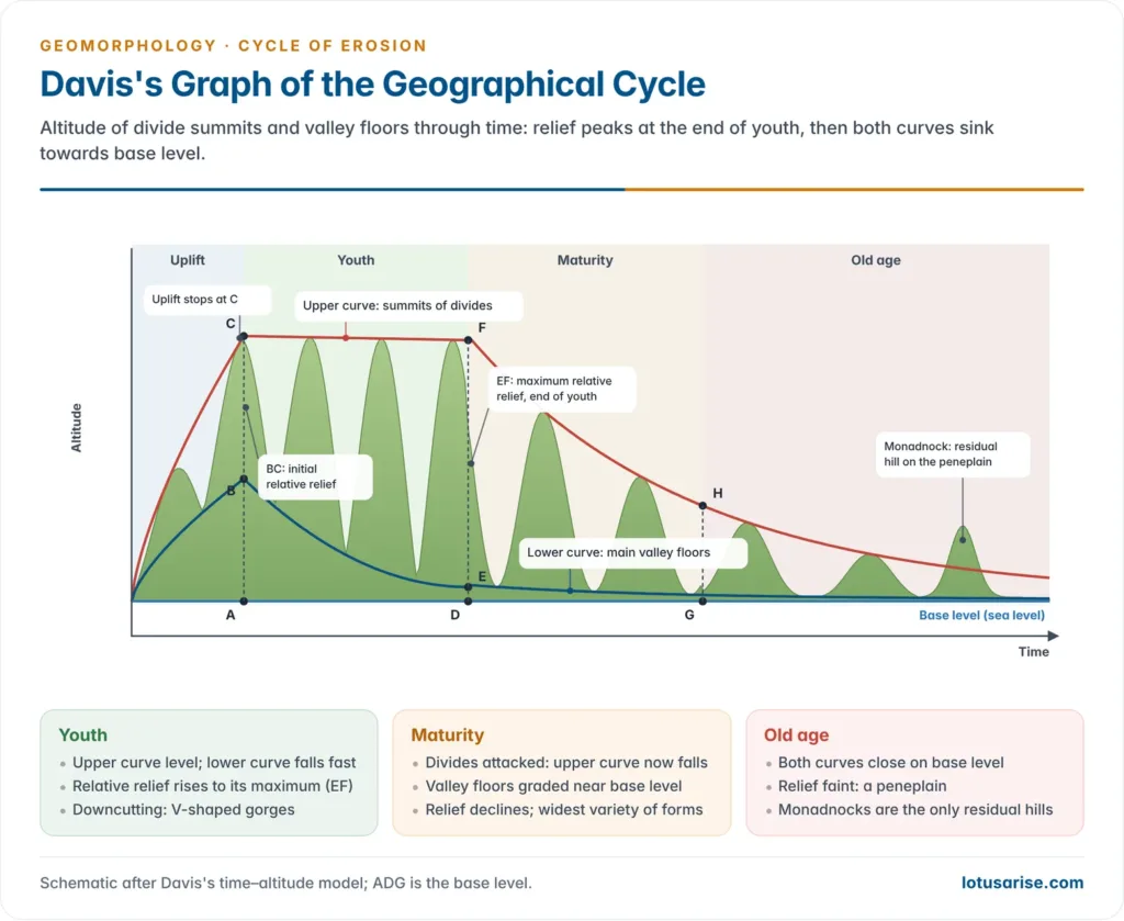
- William Morris Davis coined peneplain in 1889 (Latin pene, almost + plain) for the “almost-plain” of old age in his cycle of erosion.
- Since the ultimate base level can be approached but never reached, the end form is a near-plain, not a perfect plain.
- He defined it as a surface of regional extent, low local relief and low absolute altitude produced by long-continued fluvial erosion in a humid climate.
- Davis admitted the idea was not his: he met it in John Wesley Powell’s Exploration of the Colorado River (1875); only the name was his.
- The concept was attacked from the start, and later by advocates of non-cyclic (dynamic equilibrium) views of landscape.
Characteristic Features
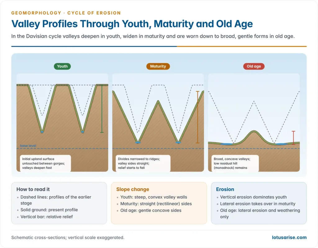
- Old-stage processes: valley deepening stops; lateral erosion, downwasting and weathering lower the interfluves; valleys become broad and flat with concave side slopes.
- Rivers reach base level, flow sluggishly, meander and braid across wide floodplains.
- Surface form: Davis never described a dead-flat plain but a low, undulating, rolling surface with gentle seaward slope so streams can keep flowing.
- Residual hills:
- Monadnocks: isolated convexo-concave hills of resistant rock standing above the plain, named after Mount Monadnock, New Hampshire.
- Unakas: residual hills in groups, after the Unaka Mountains on the Tennessee–North Carolina border.
- Near-end product: Davis accepted that erosion to a perfect plain is theoretical.
- Time: it needs a very long period of crustal stability, the weakest point of the cyclic idea.
Examples of Peneplains
- Appalachians (USA): the classic staircase of three peneplains, from highest (oldest) to lowest:
- Schooley peneplain: originally dated to about the Cretaceous–Eocene boundary.
- Harrisburg peneplain: cut after uplift of the Schooley surface.
- Somerville peneplain: the youngest, cut after a further uplift.
- Others: the Rocky Mountains of Colorado, the Tien Shan, the Scottish uplands, the Quebec plateau, the uplands of Germany, the Central Massif of France and South Africa.
- India, Ranchi plateau: an extensive surface at about 610 m was cut before the Late Cretaceous lava flows and is still preserved on the central plateau.
- The western Patland carries flat-topped pats (Netarhat, Jamira, Khamar, Rudni, Bagru, Lota pats) capped by lava and laterite, whose even crests are structural, not erosional.
- Below the lava cap, the gneissic floor at about 915 m is the old surface uplifted by about 305 m in the Tertiary.
- Other Indian cases: the Meghalaya plateau and parts of the Karnataka plateau carry old uplifted shield surfaces, and the Aravallis are a worn-down fold belt with residual ridges.
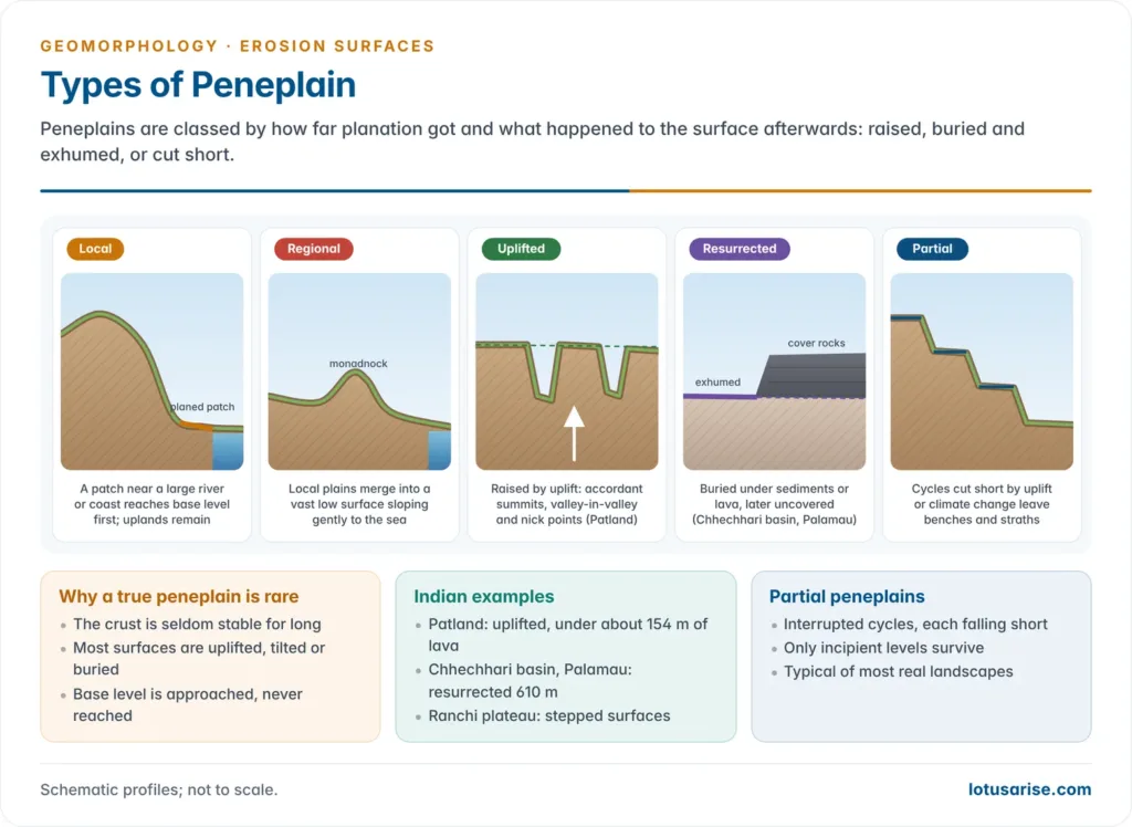
Types of Peneplains
| Type | Formation | Key features | Example |
|---|---|---|---|
| Local (incipient) | Part of a landmass reaches base level first | Small subdued patch in a larger upland | Near large rivers or coasts |
| Regional | Local peneplains coalesce | Slopes seaward; monadnocks; undisturbed and uncovered | Rare in pure form |
| Uplifted | Local or regional peneplain raised by endogenetic forces | Accordant summits, valley-in-valley, nick points | Appalachian surfaces; Patland |
| Resurrected (exhumed) | Buried under sediments or lava, later uncovered | Old surface re-exposed to erosion | Chhechhari basin, Palamau |
| Partial | Cycle interrupted by uplift, climate or sea-level change | Straths, berms, benches | Most real landscapes |
- Regional peneplains form when coastal lowlands are planed first and the planed zone advances inland, leaving low divides and monadnocks.
- A true in-situ regional peneplain, neither moved nor buried, is unlikely because the crust is unstable.
- Partial peneplains: following Nevin Melancthon Fenneman, most regions go through several interrupted cycles; each falls short of the one before, so no cycle is completed and only incipient levels survive.
- Buried and resurrected peneplains:
- A peneplain may be buried under sediments or submerged during a marine transgression and covered by marine beds.
- When the cover is eroded it re-emerges as a resurrected (exhumed) peneplain.
- India: the gneissic floor below about 154 m of lava on the Patland is buried; the 610 m surface of the Chhechhari basin in the Palamau upland is resurrected, its cover removed by the Burha river and tributaries.
Identifying an Uplifted Peneplain
- Accordance of summit and interstream levels:
- Interstream areas lie between streams; summit areas are small hilltops.
- When their heights match, they form accordant summit levels and accordant interstream levels, the relics of the old plain, often with its monadnocks.
- Older uplifted peneplains show narrow accordant crests; recently uplifted ones keep broad flat divides.
- Topographic unconformity (discordance): younger landforms below, older above.
- Rejuvenated rivers cut deep, narrow valleys inside broad old valleys, giving valley-in-valley (two-storeyed) topography.
- Knick points (heads of rejuvenation) break river long profiles.
- India: the Burha, a tributary of the North Koel, has three knick points, the highest marked by Lodh (Budha Ghagh) Falls, about 143 m, Jharkhand’s highest waterfall.
- Sediment cover: patchy residual soil and regolith (laterite, clay, chert) on the old surface and alluvium in old valleys.
Criticism of the Peneplain Concept
- Davis answered his critics point by point in “The Peneplain” (1899):
| Objection | Davis’s reply |
|---|---|
| Some regions show no trace of peneplanation | True; the idea is not meant for every rugged region |
| Uplands are not of uniform altitude | Due to tilting, imperfect planation and later dissection |
| Remnants are fragmentary | Natural after dissection; fragments are linked by reasoning |
| Many “peneplains” are inclined | Tilting is shown by the peneplain itself |
| Discordance with structure is doubtful | Surfaces clearly truncate structures |
| Monadnock rocks not proved more resistant | Resistance inferred from their form |
| No peneplain stands at base level today | A corollary of recent uplift, not an assumption |
| The crust never stays still long enough | Slow movements without dissection are allowed |
| No part of Earth approaches a peneplain | Buried and uplifted remnants prove they existed |
- Later criticism:
- Crustal instability: long still-stands are rare in a plate-tectonic Earth, as Walther Penck had argued.
- Few peneplains lie near sea level today; most “peneplains” are uplifted, warped and dissected.
- Circular reasoning: accordant summits are used to prove a peneplain, and the peneplain is used to explain the summits.
- Dynamic equilibrium: John Tilton Hack (1960) showed Appalachian ridge-and-valley forms can be explained by adjustment to rock resistance under steady erosion, without the Schooley and Harrisburg peneplains.
Other Planation Surfaces
Pediplain
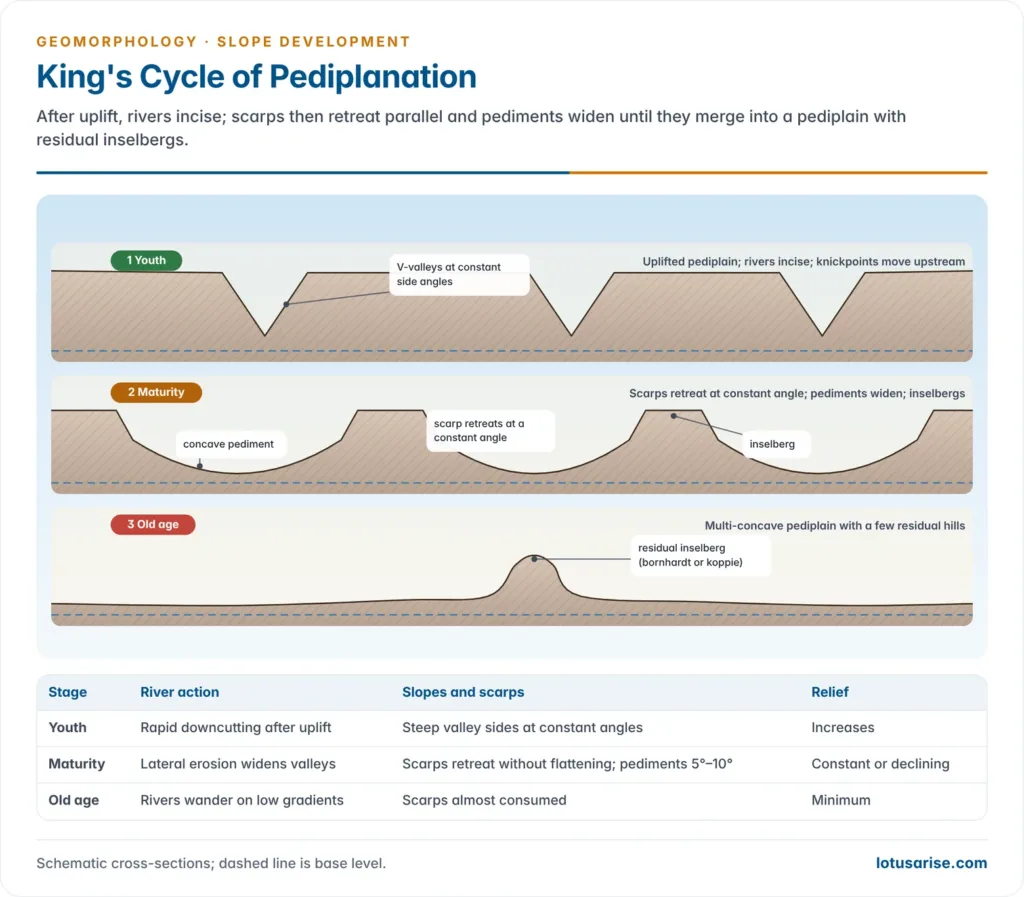
- Lester Charles King (1953), building on Penck’s slope ideas and Alan Wood’s slope elements, argued that scarps retreat parallel to themselves, leaving pediments at their foot; coalesced pediments form a pediplain, with inselbergs as residuals.
- A cycle of pedimentation begins with a burst of cymatogenic (broad arching) uplift and continues through quiescence.
- Eroded sediment unloads the continent and loads the offshore; the margin rises, a coastal scarp forms and retreats inland.
- Repeated cycles build a staircase of pediplains, the oldest farthest inland (as in southern Africa).
Primärrumpf and Endrumpf
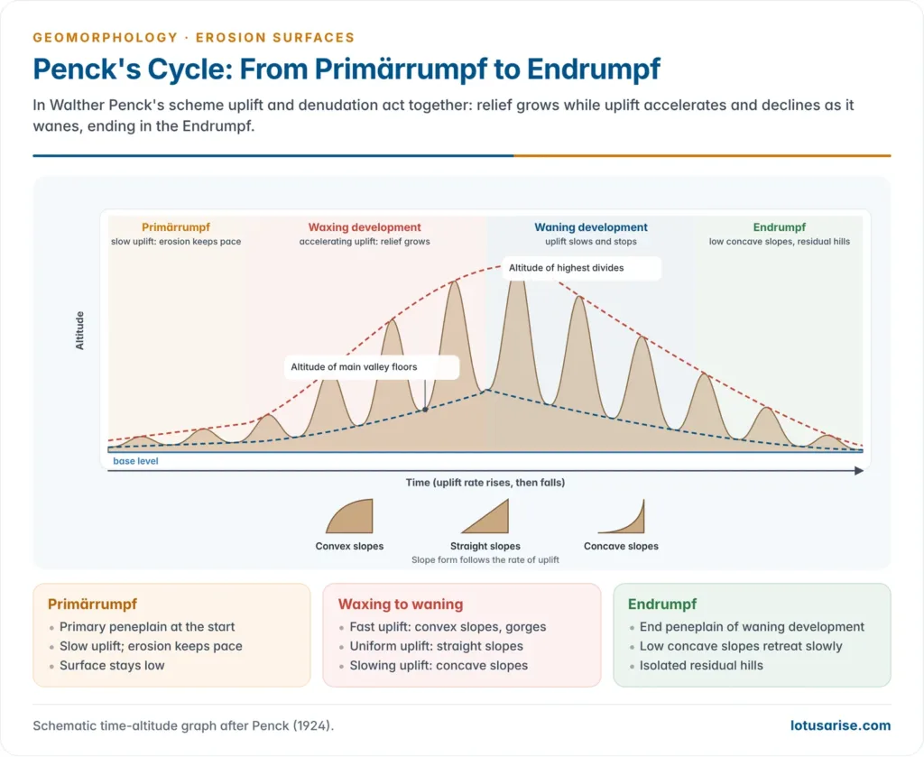
- Walther Penck (1924) linked landforms to the rate of uplift, with uplift and denudation acting together, not alternately as in the Davisian scheme.
- Primärrumpf (primary peneplain): a low surface kept low during slow initial uplift, when erosion keeps pace.
- Endrumpf (end peneplain): the final surface of waning development, a landscape of low-angle concave slopes retreating slowly, with isolated residual hills.
- In Penck’s scheme, slope evolution builds the whole landscape; slopes are replaced from below by gentler ones.
Panplain
- Colin Hayter Crickmay (1933) rejected Davisian late-stage processes and proposed panplanation:
- Residual hills are steep and concave in plan, not convexo-concave.
- Divide wasting and slope decline are slow and minor in the late stage.
- Many planation surfaces are near-perfect levels, not undulating.
- Several surfaces occur in series in one area, though Davis’s model implies a lower surface should destroy the higher one.
- Mechanism: once downcutting stops, meandering rivers erode laterally, undercutting interfluves into cliffed floodplain margins.
- Interfluves are narrowed and removed; floodplains coalesce into a flat confluence plain, the panplain, veneered with thin alluvium.
- Unequal activity (1975): erosion acts only where a stream or the sea attacks a slope base; the rest of the landscape stays almost untouched.
- Evaluation: it overstates lateral erosion in the late stage and won limited acceptance, but it rightly stressed that surfaces can be flat and can survive side by side.
Etchplain
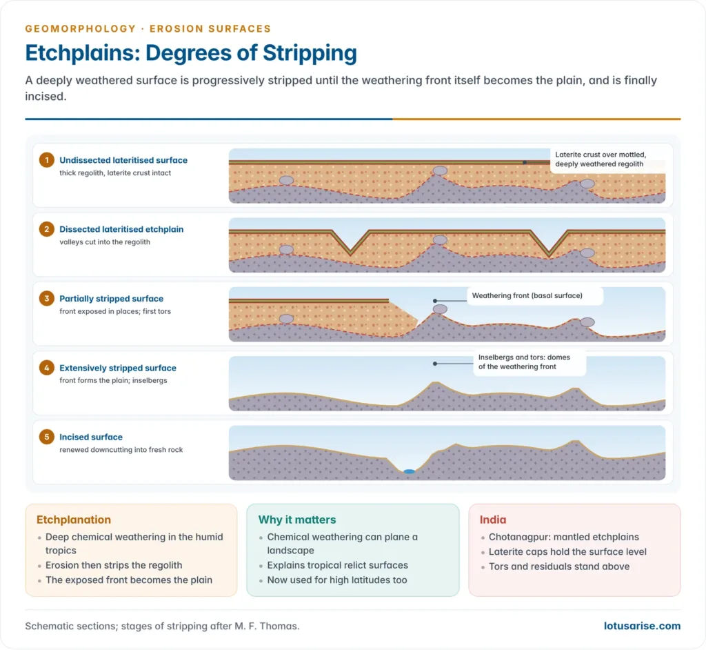
- Etchplanation: in the humid tropics, deep chemical weathering forms a thick regolith, which erosion later strips; the exposed weathering front (basal surface) becomes an etchplain.
- The term was coined by Edward James Wayland for surfaces in Uganda, and Bailey Willis (1936) spoke of etched peneplains.
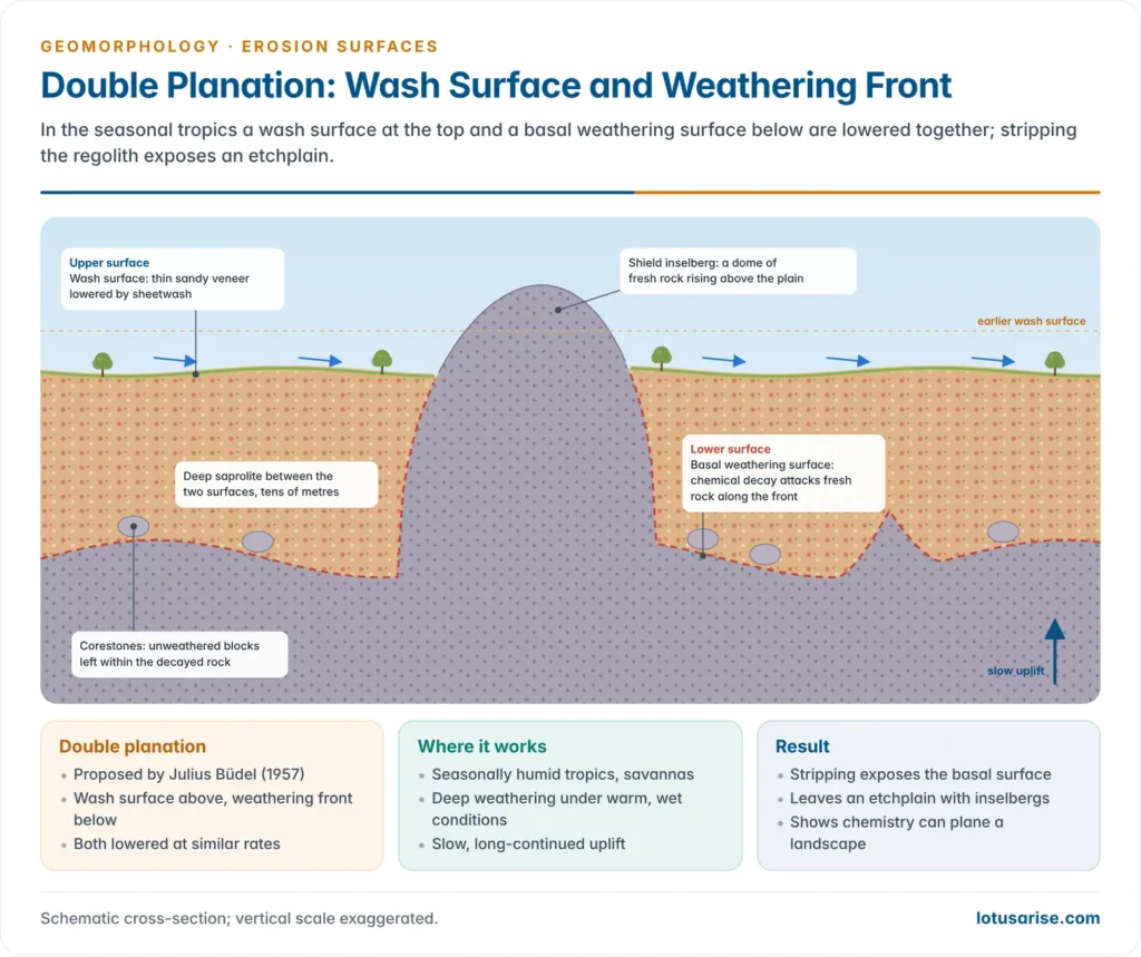
- Julius Büdel (1957) proposed double planation surfaces: a wash surface at the top and a basal weathering surface below, lowered at similar rates during slow uplift.
- It shows that chemical weathering, not only mechanical erosion, can plane a landscape.
- Michael F. Thomas distinguished etchplains by the degree of stripping:
- Undissected lateritised surface
- Dissected lateritised etchplain
- Partially stripped surface
- Extensively stripped surface
- Incised surface
- India: parts of the Chotanagpur plateau are mantled etchplains: bedrock hidden under thick regolith capped by laterite, which holds the surface level; tors and residuals project above it.
- The term also applies to surfaces on non-crystalline rocks and helps explain tropical relict surfaces now found in temperate latitudes; since the 1980s it is used for weathered flat landscapes at high latitudes too.
Panfan
- Andrew Cowper Lawson (1915) used panfan for the end stage of landscape development in arid regions, the desert counterpart of the humid peneplain.
- It forms as pediments and alluvial fans spread and merge until the mountains are consumed.
Identification and Dating of Erosion Surfaces
Problems of Identification
- Displacement: after planation most surfaces were uplifted, warped or tilted; few lie near present sea level, and one near sea level has usually subsided.
- Shifting base level: sea level has risen and fallen with glacial–interglacial cycles and tectonic movements, so no single base level fits all surfaces.
- Age limit: a complete surface needs a long time, so true erosion surfaces younger than the Tertiary are unlikely; Quaternary levels are only partial.
- Modification: the longer a surface exists, the more it is altered by erosion, deposition, sea-level change and, locally, by human activity.
- Structural look-alikes: a flat bench may be structural, a terrace or a lava cap rather than an erosion surface.
Factors Controlling Modification
- Age: older surfaces are more altered.
- Cover: a thick sediment or lava cover protects a surface.
- Rock resistance: resistant rocks are denuded slowly, weak rocks are soon replaned.
- If two surfaces lie side by side at one height, the one on resistant rock is likely older.
- Drainage density and stream frequency: a densely dissected surface is destroyed sooner.
- Resulting forms:
- Late Tertiary surfaces on resistant rock: extensive plateaus with flat-topped, accordant interfluves.
- Mesozoic or older surfaces: broken into accordant summit levels.
- Pre-Mesozoic surfaces: usually obliterated, unless buried and exhumed.
Methods of Identification
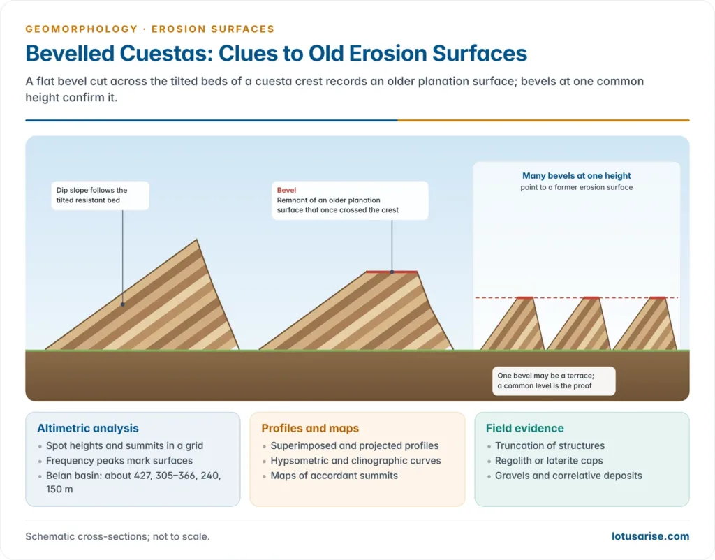
- Altimetric frequency analysis: spot heights, summits, benches and shoulders in a grid are plotted as histograms and curves; frequency peaks mark surfaces.
- It does not show whether a level is structural, tectonic or erosional; field checks decide that.
- India: the Belan basin (Uttar Pradesh) shows peaks at about 427 m (Kaimur), 305–366 m (Panna), 240 m (Rewa) and 150 m (Trans-Ganga–Yamuna) surfaces.
- Superimposed profiles: many parallel cross-profiles drawn on one base; crowding of profile crests at one level marks a surface (the same four Belan levels appear).
- Other morphometric aids: projected profiles, clinographic and hypsometric curves, and maps of accordant summits.
- Bevelled cuestas: a flat bevel across the crest of a cuesta suggests an older surface at that level.
- One bevel is not proof (it may be a terrace); many bevels at a common height are.
- Field evidence: truncation of structures, regolith or laterite caps, gravels and correlative deposits on the surface.
Methods of Dating
- Height correlation: all remnants at one accordant level are grouped and matched with a surface of known age elsewhere.
- It assumes an originally continuous, uniform surface later dissected; warping and tilting make it risky.
- India: it has been applied to the Chotanagpur highlands and Ranchi plateau, where the pats stand at accordant heights.
- Geological unconformity and cover: a surface buried under dated sediments or lava is older than its cover.
- Exposed or reworked covers make this uncertain.
- Current methods give numerical ages:
- Apatite fission-track and (U-Th)/He thermochronology date the cooling, and so the burial and exhumation, of rocks beneath a surface.
- Cosmogenic nuclides measure how fast a surface is being lowered today.
- ⁴⁰Ar/³⁹Ar dating of weathering minerals dates the lateritic cover itself.
- India, recent evidence: a 2020 argon-dating study of supergene manganese oxides in the Western Ghats found weathering episodes at about 53–44, 39–22 and 14–10 million years ago.
- These date three successive lateritised palaeolandscapes lowered very slowly (about 8 m per million years) and incised mainly in the Neogene.
- The Western Ghats crest is thus a relict of an old South Indian plateau, much like a stepped series of etchplains.
- The Ranchi plateau shows four levels (about 1,000–1,100 m, 915 m, 610 m and 305 m); only the 610 m level is a true erosion surface, the others being structural, uplifted or differentially eroded, a sequence read through denudation chronology.
Current View of Erosion Surfaces
- After the mid-20th century, the search for erosion surfaces fell out of fashion, especially in Britain, as process studies and dynamic equilibrium took over.
- The present consensus is that planation surfaces are real and interest has revived:
- Stepped landscapes of passive margins (Scandinavia, Greenland, southern Africa, the Western Ghats) are now read as surfaces uplifted in stages, and are used to reconstruct uplift, burial and exhumation.
- Their origin is now explained by several processes (etchplanation, pedimentation, lateral planation), not by one cycle.
- In stable shields such as Peninsular India, surfaces tens of millions of years old survive because denudation is slow.
Previous Year Questions
2023Define Peneplains. Describe the landscape features associated with peneplains under different geomorphic cycles.2020Discuss the problems of erosional surfaces and explain the different methods to identify them with suitable diagrams.2014State the concept of erosion surfaces and highlight the factors responsible for their development.2004Write short note: Peneplain





Good! Covered extensively!
Nice and to the point coverage of topic. Hats off