

State the concept of erosion surfaces and highlight the factors responsible for their development. (2014)
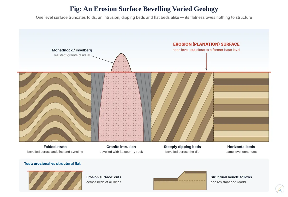
- An erosion (planation) surface is an extensive land surface of low relief produced by long-continued denudation close to a former base level, which truncates rocks of differing resistance, structure and age alike.
- Its flatness is the work of erosion, not geology — this distinguishes it from a structural surface, which follows a resistant bed exposed by stripping of weaker strata above.
The Concept
- Genetic family: the end-forms of different erosional systems are all erosion surfaces —
- peneplain (William Morris Davis, slope decline under humid conditions);
- pediplain (Lester Charles King, parallel scarp retreat and pedimentation);
- panplain (Colin Hayter Crickmay, lateral river planation);
- etchplain (deep chemical weathering and stripping of the regolith);
- plain of marine abrasion (Andrew Crombie Ramsay, 1846);
- cryoplain (periglacial cryoplanation).
- A time-marker: each surface records a period of base-level stability; once uplift interrupts it, the surface survives as accordant summits, plateau remnants or benches, and a stack of such levels records a polycyclic history.
- Partial surfaces: valley-side benches, strath terraces and marine platforms are incomplete versions of the same idea.
- Indian examples: the Ranchi surface (about 600 m) and the uplifted pre-trap surface beneath the lava-capped pat lands of western Chotanagpur and the stepped, laterite-capped surfaces of the Deccan and Karnataka plateaus.
Factors Responsible for Their Development
1. Base level and the time it stays fixed
- Planation proceeds only towards a base level — sea level for open drainage, a basin floor for interior drainage; any change in base level resets the system.
- Time is the scarcest ingredient: reducing a landmass to low relief takes millions of years, so complete post-Tertiary surfaces are rare and most surviving surfaces are Tertiary or older.
- Eustatic change (glacial and interglacial sea levels) adds benches near coasts without any tectonic movement.
2. Tectonic regime and isostasy
- Episodic uplift with long stillstands favours surfaces (the assumption of both William Morris Davis and Lester Charles King); accelerating uplift, in Walther Penck’s scheme, builds relief instead of an end-form, which is why active orogens rarely carry them.
- Isostatic rebound: as erosion unloads the crust, it rises, so planation takes far longer than simple erosion rates suggest.
- Rifted margins create competing base levels: in South India the high plateau draining to the Bay of Bengal and the low coastal belt below the Western Ghats escarpment have been planed towards different base levels.
- Warping, tilting and faulting decide where surfaces are preserved and at what height.
- Current evidence (2016): Fred D. Richards, Mark J. Hoggard and Nicky J. White, inverting 530 Indian river profiles, found that the peninsula’s west-to-east tilt grew at up to 0.1 mm per year since about 25 Ma, starting in the south and propagating northward, driven by hot asthenospheric mantle; uplift began before the monsoon intensified about 8 Ma ago — so the rock uplift that dissects Indian surfaces is mantle-driven, not purely climatic.
3. Climate and the process regime
- Climate decides which process planes the land:
- humid temperate: fluvial slope decline (peneplain);
- semi-arid and savanna: pedimentation and scarp retreat (pediplain);
- humid tropics: deep weathering and stripping (etchplain), the double planation surfaces of Julius Büdel;
- cold climates: frost action and solifluction (cryoplain);
- arid basins: wind deflation, which in William Morris Davis’s arid cycle lowers a rock floor independently of sea level.
- Climatic change during the long life of a surface makes most surfaces polygenetic: periods of etching may alternate with periods of pedimentation.
4. Lithology and structure
- Homogeneous crystalline shields (Peninsular India, Africa, Australia, Brazil) favour broad surfaces; alternating hard and soft strata produce cuestas and structural benches instead.
- Resistance sets the pace: where two surfaces stand at the same height, the one on resistant rock is generally the older, because planing it took longer.
- Resistant masses remain as monadnocks or inselbergs; joint spacing controls where weathering fronts deepen and where bornhardts and tors emerge.
5. Drainage density and protective covers
- A surface with dense drainage is dissected and destroyed sooner; sparse drainage on resistant rock preserves it longest.
- Duricrusts (laterite, bauxite, silcrete), lava sheets such as the Deccan Trap, and burial under sediments shield surfaces, which may later be exhumed.
- Judgement: an erosion surface forms only where long base-level stability, a planing process suited to the climate and receptive lithology coincide; recent work shows that the timing of uplift — often mantle-driven — decides whether a surface is completed, raised and preserved, so tectonic history matters as much as climate in explaining where erosion surfaces exist today.