

Discuss the problems of erosional surfaces and explain the different methods to identify them with suitable diagrams. (2020)
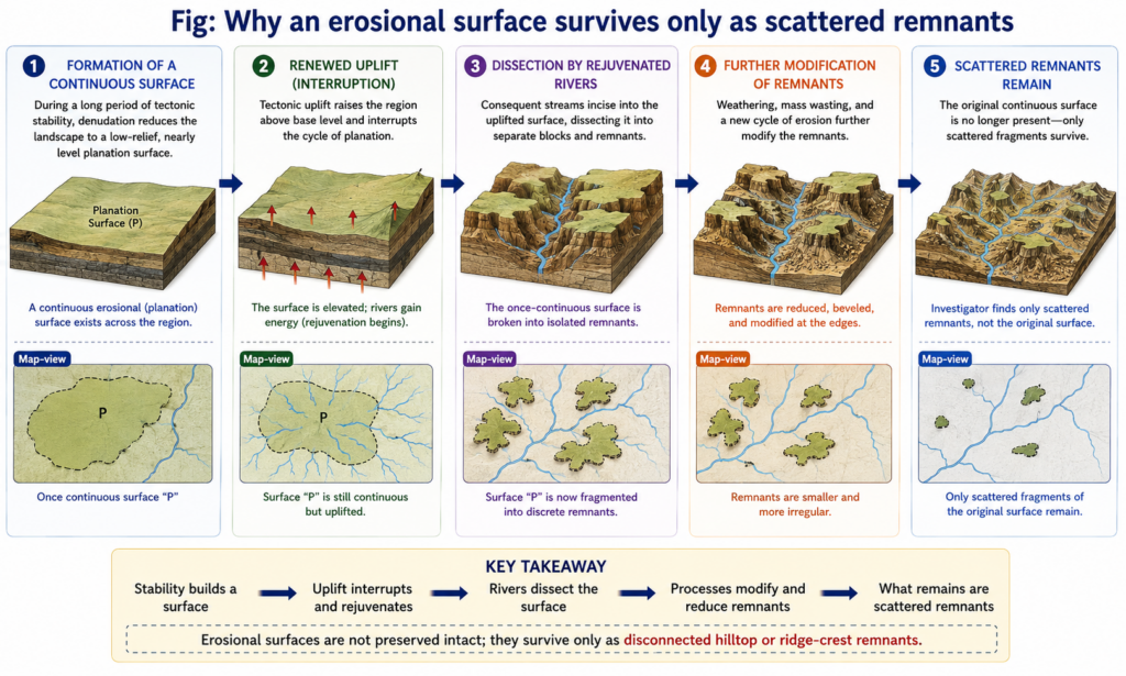
- Erosional (planation) surfaces — peneplains, pediplains, panplains, etchplains and marine-cut platforms — are the key evidence of denudation chronology, yet they survive only as dissected, uplifted, tilted or buried fragments.
- Every identification method is an attempt to answer three questions about such a fragment: is it erosional, which other fragments belong with it, and how old is it?
Problems of Erosional Surfaces
Problems of preservation
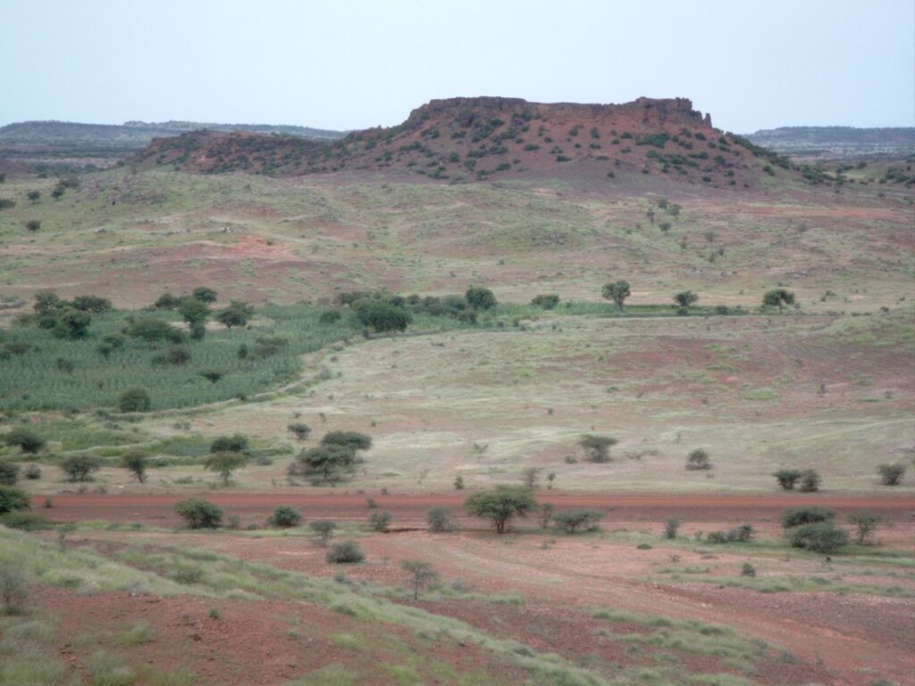
- Fragmentation: once uplift rejuvenates the drainage, the surface is consumed from its edges; older surfaces survive only as accordant summits or flat-topped hills.
- Modification: weathering, mass wasting and later cycles lower and round the remnants, so their original height and form must be inferred.
- Age bias: completing a planation surface takes millions of years, so few post-Tertiary surfaces exist; the survivors are mostly Tertiary or older — and therefore the most degraded.
- Burial and exhumation: a surface may be buried under sediments or lava and later stripped — an exhumed (resurrected) surface can be far older than the landscape around it.
Problems of interpretation
- Erosional or structural? A flat summit on a resistant horizontal bed (a structural bench) mimics a planation surface; only a level that bevels varied rocks and structures is genuinely erosional.
- Deformation: warping, tilting and faulting can make one surface appear at several heights, or two surfaces at one height — the weakness of simple height correlation.
- Equifinality of origin: peneplanation, pediplanation, etchplanation, marine abrasion and even glacial or periglacial action can all yield low relief; overlying marine deposits do not prove marine planation, since the sea may have merely flooded a fluvial surface.
- Long-distance correlation: Lester Charles King matched surfaces across Africa, South America and Australia by height and assumed age — correlations across oceans that no field test can confirm.
- Polygenesis: surfaces formed over tens of millions of years span several climates, so one surface may combine etching, pedimentation and fluvial bevelling.
- A live controversy: Rong Yang, Sean D. Willett and Liran Goren (2015) argued that high, low-relief surfaces in south-eastern Tibet formed in situ through drainage-network reorganisation; Kelin X. Whipple, Roman A. DiBiase, William B. Ouimet and Adam M. Forte (2017) developed morphometric criteria and concluded that those surfaces are relict, uplifted landscapes. A low-relief upland is therefore no longer accepted as an old surface without testing.
Problems of dating
- Bare rock carries no datable material; a surface can be bracketed only between the youngest rock it truncates (maximum age) and the oldest deposit resting on it (minimum age).
- Radiocarbon is useless beyond the late Quaternary, and the cover deposit may record only the end of planation.
Methods of Identification
Field and map evidence
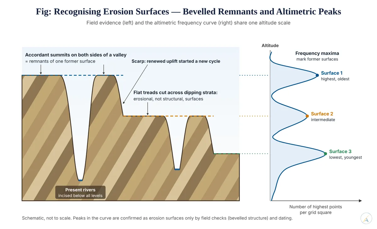
- Summit accordance: hilltops and ridge crests rising to a common level across varied geology suggest a dissected former surface.
- Bevelled structure: a level cutting across dipping strata, fold axes and intrusions is the decisive field test of erosional origin.
Morphometric methods
- Altimetric frequency analysis: the highest point in each grid square (or all spot heights and summits) is plotted against altitude; frequency maxima mark former surfaces. In the Belan basin of the Vindhyan plateau, maxima at about 427 m (Kaimur), 305–366 m (Panna), 240 m (Rewa) and 150 m (Trans-Ganga-Yamuna) were read as four erosion surfaces.
- Superimposed profiles: several parallel cross-profiles drawn on one diagram; where many profiles crowd at the same level, a surface is indicated.
- Projected and composite profiles: only the summit envelope seen from a distance is drawn, smoothing out valleys to reveal flat treads and the breaks of slope that separate surfaces.
- Generalised contours and hypsometric curves smooth valley indentations to show the stepped form of the upland.
- Digital elevation models now automate these steps through swath profiles, slope maps and local-relief maps.
- Limitation: morphometry shows levels, not origins; the class interval chosen can create or merge peaks, and field checks must still separate structural from erosional flats.
Geological and weathering evidence
- Correlative deposits and lava covers (for example, the Deccan Trap capping older peninsular surfaces) give minimum ages.
- Duricrusts — laterite, bauxite, silcrete, calcrete — form mainly on long-stable, low-relief surfaces; matching crust type and position links scattered remnants more reliably than height alone.
- Drainage anomalies — wind gaps, water gaps, superimposed and antecedent courses, captured streams and knickpoints — preserve the pattern of a vanished higher surface.
Chronometric methods
- 40Ar/39Ar dating of supergene weathering minerals in laterites dates the weathering on a surface directly.
- Apatite fission-track and (U-Th)/He thermochronology reconstruct burial and exhumation, testing whether a surface was cut near sea level and later uplifted.
- Cosmogenic nuclide concentrations (beryllium-10, aluminium-26) measure exposure and erosion rates of surface remnants.
Weighing the Methods
- Morphometric techniques are cheap and objective but cannot tell erosional from structural levels; geological and chronometric methods are decisive but available only where suitable deposits or minerals survive.
- Judgement: no single method identifies an erosion surface — a level becomes a credible surface only when morphometric clustering, cross-cutting of structure, weathering or deposit evidence and independent dating converge; the Tibet controversy shows that even sophisticated morphometry, unsupported by dating, can be read in opposite ways.