

Define Peneplains. Describe the landscape features associated with peneplains under different geomorphic cycles. (2023)
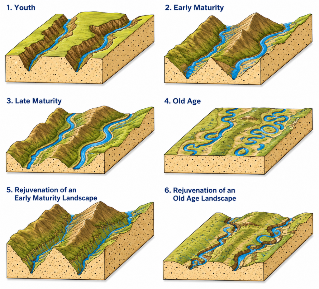
- A peneplain (“almost a plain”) is a low, gently undulating erosion surface close to base level, produced by prolonged subaerial denudation of an uplifted landmass and bevelling rocks of every type and structure alike — the term coined by William Morris Davis (1889) for the old-age end-form of his geographical cycle.
- Two tests separate it from a structural plain: it truncates structure (folds, faults, hard and soft beds alike), and it stands in a consistent relation to a former base level rather than to one resistant bed.
- Strictly, it belongs to the humid “normal” cycle; every other cycle has its own planation surface (desert plain, pediplain, Endrumpf, panplain, etchplain, karst plain), each recognisable by a distinct suite of surface features.
The Normal Cycle: The Davisian Peneplain
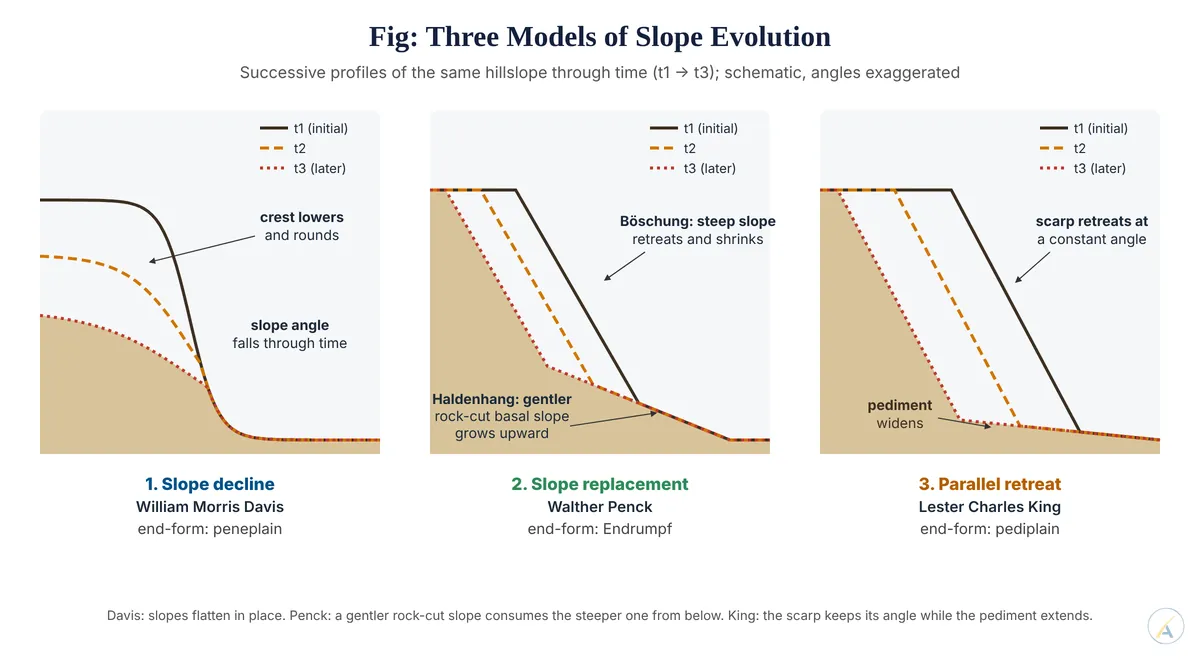
- Relief: interfluves reduced to low, soil-mantled convexo-concave swells a few tens of metres high; slopes gentle because, in William Morris Davis’s model, they decline in angle through time.
- Drainage: broad floodplains, freely wandering meanders, oxbow lakes, levees and marshes; streams sluggish and close to grade.
- Residuals: isolated hills of resistant rock — monadnocks, named after Mount Monadnock in New Hampshire — rising above the plain.
- Regolith: a deep weathered mantle, since chemical weathering outpaces removal on gentle slopes.
- Uplifted peneplains (rejuvenation) betray themselves by accordant summits, incised meanders and youthful gorges cut into an old surface — the Schooley peneplain of the Appalachians was William Morris Davis’s classic case.
The Arid Cycle: Desert Plain and Pediplain
- William Morris Davis’s arid cycle (1905) ends in a rock-floored desert plain thinly veneered with waste, lowered by wind deflation and therefore independent of sea level; residual inselbergs replace monadnocks, and shallow wind-blown hollows hold playas.
- Lester Charles King (1953) made the semi-arid and savanna case general. His pediplain is “multi-concave” — a mosaic of coalesced pediments (about 1.5°–7°) separated from upland remnants by steep scarps (about 15°–30°) that retreat parallel to themselves.
- Pediment versus bajada: the pediment is a rock-cut surface with only a thin veneer of waste, whereas the bajada beyond it is a depositional apron of coalescing fans — the pediplain is built of the former.
- Features: abrupt piedmont angle at the scarp foot, inselbergs and bornhardts, boulder-strewn castle koppies, and stepped pediplains at successive levels, because each new cycle eats headward into the older surface.
The Endrumpf and the Panplain
- Walther Penck’s waning development (absteigende Entwicklung): steep upper slopes (Böschungen) are consumed from below by gentler wash slopes (Haldenhang), leaving conical inselberg residuals; their removal yields the Endrumpf, a surface of intersecting concave wash slopes — Walther Penck’s equivalent of the peneplain, distinct from the Primärrumpf that forms under slow uplift.
- Colin Hayter Crickmay (1933) held that slopes retreat only where a river or the sea undercuts them; lateral planation by migrating rivers produces a panplain of coalesced floodplains, while unconsumed uplands keep steep sides until finally undercut.
Planation Surfaces of Other Cycles
| Cycle | End-surface | Diagnostic landscape features |
|---|---|---|
| Tropical (Edward James Wayland; Julius Büdel) | Etchplain | Deep saprolite over an irregular weathering front; stripping exposes bornhardts, tors and laterite-capped mesas |
| Periglacial (Louis C. Peltier, 1950) | Cryoplain | Cryoplanation terraces, tors, blockfields, solifluction-smoothed slopes |
| Karst (Jovan Cvijić, 1918) | Karst plain | Plain near the water table with poljes, residual hums and towers |
| Glacial (William Morris Davis, 1900) | No true peneplain | Ice-scoured knock-and-lochan lowland, roches moutonnées, lakes; old plateaus modified, not created |
| Coastal (Douglas Wilson Johnson, 1919) | Plain of marine abrasion | Wave-cut platform truncating structure, raised beaches, sea-stack residuals |
A Live Debate: Is Every Flat Upland a Peneplain?
- Hardangervidda, Norway’s plateau of about 6,500 km² at roughly 1,100–1,200 m, illustrates the problem.
- Peter Japsen, Paul F. Green, James A. Chalmers and Johan M. Bonow (2018) used fission-track thermochronology to read it as an early Miocene peneplain cut near sea level and raised in the early Pliocene.
- David Lundbek Egholm, John Duncan Jansen and colleagues (2017) modelled how ice sheets themselves can generate low-relief plateaus between fjords — so flatness alone need not mean a pre-glacial peneplain.
- Peninsular India shows the same ambiguity: Yanni Gunnell (1998) mapped several tiers of flat denudational surfaces across the South Indian shield that ignore foliation and carry a characteristic weathering mantle — features of etchplanation as much as of Davisian peneplanation.
- Judgement: the peneplain is best treated as the humid member of a family of planation surfaces; the end-form of any cycle is identified not by flatness but by its diagnostic features plus independent dating, which is why William Morris Davis’s term survives while its universality does not.