

- Denudation chronology is the reconstruction of the denudational history of a region: the order, timing and causes of the erosion cycles that have shaped its present landscape.
- It reads the landscape backwards from relict landforms (old erosion surfaces, accordant summits, knickpoints, terraces, buried surfaces and their cover deposits) to past phases of uplift, planation, sea-level change and climate.
- It is the historical (chronological) approach to landform study, built on the Davisian model of cyclic landform evolution, and it works at long geological time-scales and large spatial scales.
- Its core object is the erosion (planation) surface, whether peneplain, pediplain, panplain or etchplain.
Meaning and Basis of Denudation Chronology
Denudation: the Process Being Dated
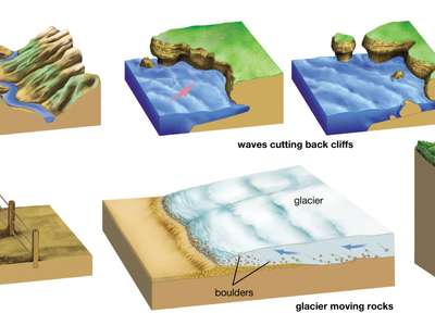
- Denudation is the sum of processes that wear away the Earth’s surface by running water, ice, wind and waves, lowering both elevation and relief.
- Denudation = Weathering + Mass wasting + Erosion (with transportation of the debris).
- Where denudation continues long enough close to a stable base level, the result is a near-flat erosion surface cutting across rocks and structures.
Definitions
- Core meaning: reconstruction of the chronological history of denudation of a given region.
- R. J. Small (1970): the aim is to identify, date and interpret planation surfaces developed in past cycles and sub-cycles of erosion.
- The evidence used is drainage development, river capture, relict surfaces and past tectonic events.
- Standard dictionary sense: the branch of landform study dealing with the historical development of landscapes by denudation, especially during pre-Quaternary time.
- Evidence comes from erosion surfaces and their mantling deposits, drainage patterns, stream long-profiles and geological structures.
- Cuchlaine A. M. King (1966) stressed its assumption: the landscape is analysed historically, on Davis’s cyclic concept, because evidence of its past character is still visible in its present form.
Basic Concepts Behind the Approach
- Sequential change: landforms pass through successive stages through time, so each stage leaves recognisable forms.
- Uniformitarianism: processes acting today acted in the past; hence the dictum “the present is the key to the past”.
- Cyclic nature of Earth history: phases of uplift → planation → renewed uplift recur, each opening a new cycle of erosion.
- Palimpsest topography: the surface carries the overprinted imprints of several past cycles.
- Davisian cycle of erosion: a cycle interrupted by uplift or base-level fall (rejuvenation) leaves an older surface above a younger one, producing polycyclic relief.
Palimpsest Topography
- A palimpsest is a manuscript that has been written, erased and rewritten several times, with traces of earlier writing still showing.
- Palimpsest topography is a landscape built in the same way:
- Written: geomorphic processes create a set of landforms.
- Erased: later processes partly destroy them.
- Rewritten: new relief is carved on the older surface, several times over.
- The present landscape is therefore polygenetic and polycyclic; denudation chronology tries to separate and date these layers.
- Peninsular India, with surfaces dating from the Precambrian to the Quaternary, is a classic palimpsest landscape.
Evidence Used
- Relict erosion surfaces: flat interfluves, plateau tops and accordant summit levels.
- Drainage evidence: superimposed and antecedent courses, river capture, barbed tributaries and misfit streams, which record changes in slope and base level.
- Stream long-profiles: knickpoints, waterfalls and gorges marking successive uplifts.
- Deposits: sediments resting on a surface (cover deposits), correlative sediments in adjacent basins, laterite and duricrust caps, and unconformities.
- Tectonic evidence: faults, warps, tilts and lava flows that bury or displace older surfaces.
- The precision of a reconstruction depends on the deductive power of the researcher and the quality of qualitative and quantitative description of the relict features.
Growth of the Approach
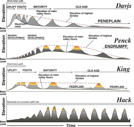
- William Morris Davis (1899) supplied the frame: cycles of erosion, peneplains and their rejuvenation.
- The British school made it the dominant method of the early 20th century.
- Sidney William Wooldridge and David L. Linton (1939) identified successive Tertiary surfaces in south-east England, the model study of the approach.
- The Indian school (Varanasi, National Geographical Society of India) applied it to the Chotanagpur highlands, the Vindhyan uplands and the Peninsula from the 1960s onward.
- Lester Charles King extended it to the continent-wide pediplains of Gondwana fragments.
Identifying and Dating Erosion Surfaces
Identification
- Erosion surfaces are recognised by morphometric and field techniques:
- Altimetric frequency histograms and curves: peaks in the frequency of spot heights at certain levels mark surfaces.
- Superimposed and projected profiles: parallel summit lines across many profiles show a former continuous surface.
- Clinographic curves and slope maps: flats separated by steeper breaks of slope.
- Accordant summit levels, benches and knickpoints, checked against structure so that rock-controlled flats are not mistaken for erosion surfaces.
Relative Age from Form and Rock
- Lithology: a surface on resistant rock takes longer to form and to be destroyed.
- If two surfaces stand at the same height, one on resistant and one on weak rock, the one on resistant rock is usually the older.
- Drainage density: surfaces with high stream frequency and drainage density are dissected and destroyed sooner.
- State of preservation gives a rough age:
| Age of surface | Typical present form | Reason |
|---|---|---|
| Late Tertiary (pre-Quaternary) | Extensive plateaus, flat-topped interfluves | Little time for dissection |
| Mesozoic | Fragments; accordant summit levels only | Deeply dissected |
| Pre-Mesozoic | Usually obliterated, unless buried and later exhumed | Long denudation |
Dating Methods
| Method | Principle | Main limitation |
|---|---|---|
| Height correlation | Remnants at accordant heights belonged to one surface; date by matching with a surface of known age | Warping and tilting shift remnants; relative, not absolute |
| Cover deposits and unconformity | Sediment or lava resting on a surface gives a minimum age | Gives only the end date; deposits get reworked or mixed |
| Correlative sediments | The coarse-to-fine sequence in nearby basins records erosion of the highland | Link between source and basin must be proved |
| Drainage history | Reconstructing the evolution of drainage on the surface | Interpretive |
| Radiometric dating | Absolute ages from radioactive decay | Needs datable material; method must match age range |
- Height correlation assumes the surface was continuous and roughly level when formed, then fragmented by rejuvenated streams.
- It works best on post-Tertiary and young surfaces; older surfaces have usually been deformed.
- Indian example: the western Ranchi plateau (Pat region) was reduced to a surface before the lava cover, later uplifted, and now survives as flat-topped “pats” at accordant heights of about 1,000–1,100 m, such as the Netarhat, Jamira, Khamar, Rudni, Bagru and Lota pats, isolated by the North Koel and its tributaries.
- Cover deposits can mislead:
- Marine sediments on a surface do not prove a marine origin; they may have crept down from an adjacent coast or been laid during a transgression over a fluvially cut surface, then buried under fluvial deposits after the sea withdrew.
- King noted that sediments date only the final phase of a surface; the Gondwana surface of southern Africa predates the break-up of Gondwana but was wrongly dated as Tertiary because it carried Miocene deposits.
- Radiocarbon dating reaches back only about 50,000 years, so it can date Late Quaternary terraces and soils but not Tertiary or older surfaces.
- Older surfaces are now dated by the newer methods listed under the current view below.
Indian Case Studies
Chotanagpur Highlands
- The classical reconstruction by R. P. Singh (1969) combined cycle analysis, structure, deposits, drainage patterns, morphometry and fieldwork. The Chotanagpur landscape is polycyclic and an ideal palimpsest.
| Cycle or surface | Main events | Surviving evidence |
|---|---|---|
| Pre-Dalma cycle | Archaean folding and uplift; trellis drainage; fluvial planation, ended by the Dalma lava flow | Unconformities in the Dhanjori highlands, where Dhanjori sandstone–conglomerate overlies the old surface; folded lavas of the Porhat hills |
| Precambrian surface | Fluvial erosion exposed the granite–gneiss basement | Kolhan sandstone–conglomerate lying flat on dissected granite; Vindhyan rocks on the Precambrian surface in the north-west |
| Carboniferous glaciation | Gondwana ice sheets closed the earlier cycle, rounded hills and left a monotonous, poorly drained surface with lakes and swamps | Talchir boulder beds below the Gondwana coal seams |
| Permian–Triassic cycle | Denudation after the ice; Triassic uplift and faulting; region reduced to a peneplain | Horizontal Gondwana beds in fault troughs |
| Gondwana (pre-Tertiary) surface | Extensive, low, undulating surface sloping east; interrupted by Mesozoic lava flows | Surfaces matched across other Gondwana fragments |
| Tertiary cycles | Three uplifts linked to Himalayan orogeny, the first two of about 305 m each; mid-Tertiary “Hundru falls cycle” | Dissected plateau margins, falls, gorges, incised valleys |
- Knickpoint falls along the north-east–south-west plateau edges record the Tertiary rejuvenation:
- Hundru Falls (about 98 m) on the Subarnarekha.
- Dassam Falls (about 44 m) on the Kanchi.
- Jonha (Gautamdhara) Falls (about 43 m), a hanging-valley fall into the Raru.
- Breaks in the long-profiles of the North Koel, Sankh and Burha point to later uplift of the western Ranchi plateau and the Palamau upland.
- The south-east of Chotanagpur, uplifted less, shows a less complete Tertiary record.
Ranchi Plateau: Surfaces and Their Origin
- The Ranchi plateau (south-western Chotanagpur) has five units: Pat region (western highlands), central plateau, southern dissected plateau, eastern lower plateau and northern escarpments facing the Damodar rift.
- Average heights fall from about 1,066 m in the west to 685 m in the centre and 305 m in the east and south.
- The basement is Dharwar-age metasediments intruded by granite, with gneissic domes rising above the peneplain.
- Sequence: Archaean folding → sub-aerial cycle, interrupted by the Dalma lava in the south → Carboniferous glaciation (relics only in the North and South Karanpura coalfields) → Permian–Triassic peneplain → uplift of the west by about 305 m and lava cover → three Tertiary uplifts → Quaternary alternation of arid and humid phases under a mainly hot, humid monsoon regime.
- The debate over the number of surfaces:
- J. A. Dunn (1931) treated the western higher plateau as a separate peneplain.
- S. P. Chatterjee (1940) recognised four surfaces below the Netarhat mesa.
- R. P. Singh (1969) accepted three: 915 m, 610 m and 305 m, and allowed that the difference between the first two might be differential erosion under a protective lava cap.
- S. C. Chatterjee (1945) doubted any multiple peneplains and read the lower levels as the result of erosion alone.
- Morphometric reading: altimetric curves and superimposed profiles show four levels, but not all four are erosion surfaces.
| Level | Where | Interpretation |
|---|---|---|
| 1,000–1,100 m | Pat region mesas and buttes | Structural: flat because of horizontal lava beds, now laterite-capped; never peneplained |
| 915 m | Gneiss–laterite junction in the west | Uplifted peneplain: part of the central surface raised about 305 m |
| 610 m | Central Ranchi plateau | True erosion surface |
| 305 m | Eastern and southern plateau | Differential erosion of softer rocks |
- The last three were once one extensive erosion surface, formed before the first uplift of the western highlands.
- Lesson for the method: a flat is not automatically an erosion surface; structure and lithology must be ruled out first.
Peninsular India: Landscape Cycles
- Present set-up: the Peninsula is a mosaic of fault-bounded plateaus (Malwa, Deccan, Mysore, Chotanagpur) ringed by old, dissected, flat-topped ranges: the Aravallis, Vindhyan and Kaimur scarps, the Satpura–Maikal–Mahadeo hills, and the Western and Eastern Ghats.
- Flat summits on most ranges, rift valleys of the Narmada and Tapi flowing west against the general slope, and stepped scarps on the Western Ghats all record repeated uplift, faulting and planation.
- Ravine belts of the Chambal and Bundelkhand show the current phase of dissection.
- Stratigraphic frame (older classification used in these reconstructions):
| Group | Main rocks | Landscape significance |
|---|---|---|
| Archaean | Granites, gneisses, Dharwar metasediments | Basement exposed by prolonged denudation; heavily folded |
| Purana | Cuddapah and Vindhyan sandstones, shales, limestones | Mostly horizontal; scarps and plateaus of central India |
| Dravidian | Palaeozoic marine rocks | Largely absent in the Peninsula: a long gap in the record |
| Aryan | Gondwana beds, Rajmahal and Deccan lavas, Tertiary and Quaternary deposits | Gondwana beds hold nearly all Indian coal, in fault troughs; lavas buried older surfaces |
- The Peninsula has no large-scale marine submergence or orogeny after the Precambrian, only local transgressions (the Cuddapah and Vindhyan seas) and the side effects of Himalayan orogeny (uplift, warping, faulting).
- Landscape cycles, oldest to youngest (after R. P. Singh (1967), corrected for current dates):
| Cycle or event | Main features |
|---|---|
| Pre-Dharwar | Primeval crust eroded; sediments folded and metamorphosed into basement gneisses; charnockite intrusions (Nilgiri, Palni, Shevaroy) |
| Dharwar cycle | Mountains raised from Precambrian basins (Dharwar, Eastern Ghat, Satpura, Aravalli, Delhi) peneplained; Dalma and Dhanjori lavas; unintegrated drainage |
| Cuddapah–Vindhyan cycle | Uplift of Cuddapah and Vindhyan rocks; three drainage axes (Western Ghat, Satpura, Aravalli); new consequent, subsequent and obsequent streams |
| Proposed Vindhyan glaciation | Inferred from Son valley boulder beds and Ken valley tillites; stream heads buried, lower courses kept |
| Cambrian cycle | Long denudation of Vindhyan terrain; Aravallis lowered but not finally planed until about the Jurassic–Cretaceous |
| Permo-Carboniferous glaciation | Gondwana ice spread from the Aravalli axis; Talchir boulder beds; Hercynian troughs (Damodar, Mahanadi, Godavari) filled by meltwater and later Gondwana sediments |
| Gondwana cycle | Peneplanation by the Early Cretaceous; general slope northward, later changed by tilting; traces in Tamil Nadu, Madhya Pradesh, Maharashtra |
| Post-Gondwana cycle | After Gondwana break-up; bevelled summits of the Nilgiris (Udhagamandalam), Cardamom hills and high Eastern Ghats |
| Cretaceous lava floods | Rajmahal traps (Early Cretaceous, about 118 Ma) and Deccan Traps (about 66 Ma) buried older surfaces; long lateritic weathering |
| Cenozoic cycle | Western Ghats escarpment after India rifted from Madagascar and then the Seychelles; Narmada–Tapi rift valleys; accordant summits of the Mysore plateau and Nilgiri–Cardamom ranges, with monadnocks |
| Quaternary warping | Rejuvenation: knickpoints, waterfalls, gorges; raised beaches of about 30–45 m on the coasts |
- Deccan lava landscape: fluvial denudation of the basalt left hills and ridges that are erosional, not folded.
- Scarps retreat parallel to themselves by backwasting; where the laterite cap is gone, hills become conical with convexo-concave slopes.
- Where the lava is stripped, older Vindhyan relief is exhumed.
- Laterite profiles on the Chotanagpur and Mahabaleshwar plateaus record long weathering.
- Stepped surfaces of the eastern Peninsula:
- The khondalite–charnockite highlands of Andhra Pradesh and Odisha form the highest surface.
- The gneissic Bastar surface (about 610–915 m) forms the second.
- The dissected domes of Keonjhar, Mayurbhanj and Sundargarh (about 610 m) form the third.
- Quaternary knickpoint falls from rejuvenation:
- Jog (Gersoppa) Falls on the Sharavati, about 253 m.
- Shivanasamudra Falls on the Kaveri, about 98 m.
- Gokak Falls on the Ghataprabha, about 52 m.
- Dhuandhar Falls on the Narmada, about 30 m.
Belan Basin (Eastern Vindhyan Upland)
- Setting: the Belan, a tributary of the Tons in the Mirzapur–Prayagraj region, occupies a synclinal trough in Upper Vindhyan rocks (Kaimur, Rewa and Bhander series) between the Kaimur scarp above the Son valley and the Ganga plains.
- The relief is subdued, with a rectangular, joint-guided drainage pattern, stepped hill slopes, mesas and buttes of Rewa sandstone, and fault-guided falls.
- The Vindhyan rocks are overlain by a Quaternary sequence: gravel and mottled clay, red-brown gravel–sand, yellow silt, caliche, a buried soil, aeolian sand and the modern soil.
- Tectonic history:
- Reverse faulting running east–west shifted the Son valley northward and tilted the northern block. Vindhyan sandstones exposed high in the Son gorge appear lower in the Belan valley and pass beneath the Ganga alluvium near Chunar, as noted by Ram Lochan Singh (1974).
- Tertiary faulting shows in rapids, deep pools, deflected courses and displaced beds.
- Why no early planation: the Upper Vindhyans were not reduced to maturity until the Cretaceous; one explanation is protection under ice during the Late Carboniferous and Early Triassic cold phases.
- Erosion surfaces, identified from altimetric frequency (peaks near 150 m, 240 m and 420 m) and superimposed profiles, match those of R. S. Dubey (1968) on the Rewa plateau:
| Surface | Height in Belan basin | Age and cause |
|---|---|---|
| Kaimur surface | About 420 m | Probably Cretaceous; on the Kaimur hills above the Son valley |
| Panna surface | About 305 m, only patches | Miocene; cycle cut short by mid-Miocene uplift |
| Rewa surface | About 240 m, widespread | Post-Pliocene uplift |
| Trans-Yamuna–Ganga surface | About 150 m | Pleistocene–Recent; cut into the Rewa surface |
- These surfaces record interruptions of cycles rather than complete cycles.
- Quaternary climatic sequence from the cover deposits:
- Laterite crusts (warm, humid interglacial of the Upper Pleistocene).
- Boulder and mottled clay with facetted, striated clasts (cold and dry, latest Pleistocene glacial).
- Humid trenching and erosion, then red gravel–sand with rubification (reddening by weathering).
- Arid loess and caliche, a buried soil, aeolian mounds and today’s gullying under a monsoon regime.
- The basin shows how denudation chronology merges with Quaternary climatic reconstruction.
Evaluation and Current View
Significance
- Explains present landscapes as inherited: plateau steps, accordant summits, waterfalls and misfit drainage make sense only as the products of past cycles.
- Links landforms to tectonics, sea level and climate: Tertiary uplift of Chotanagpur, the rifting of the western margin, the Quaternary climatic swings of the Vindhyan uplands.
- Integrates geomorphology with geology and stratigraphy through unconformities, cover deposits and correlative sediments.
- Practical uses:
- Locating laterite-related bauxite and manganese on old surfaces.
- Reading groundwater potential in weathered mantles.
- Explaining drainage anomalies for water-resource planning.
- Setting the landscape context of Palaeolithic sites (for example in the Son and Belan valleys).
Criticism
- Explains only fragments: R. J. Small (1970) noted it accounts directly for only small parts of the landscape, the dissected remnants of old surfaces, while most of the present relief is left unexplained.
- Deductive and speculative: long histories are built from very little evidence. Old surfaces have been so modified that their original form and height cannot be recovered.
- Dating is weak: height correlation, cover deposits and drainage history give relative, often circular ages, and the result depends on the deductive power of the researcher.
- Davisian assumptions: it presumes rapid uplift followed by long stillstand and treats every flat as a peneplain. Many flats are instead structural (the Pat region), etchplains of deep weathering, pediplains, or products of differential erosion, an example of equifinality.
- Tectonics ignored or oversimplified: warping and isostatic rebound mean that equal height does not prove equal age.
- Missing correlative sediments: the eroded material should appear in adjacent basins. In south-east England, offshore drilling later failed to find the sediments that the proposed Tertiary erosion phases required.
- Shift of the discipline: from the 1950s, process geomorphology (Arthur Newell Strahler, Richard J. Chorley) turned attention to measurable present-day processes and systems, and denudation chronology lost its central place.
Current View: Absolute Dating Revives the Question
- The historical question is back, but it is now answered with numerical dates rather than height matching:
| Method | What it dates | Useful range |
|---|---|---|
| Cosmogenic nuclides (10Be, 26Al) | Exposure age of a surface and erosion rate of bedrock or catchments | Thousands to a few million years |
| Low-temperature thermochronology (apatite fission track, (U-Th)/He) | Time rocks cooled towards the surface, hence long-term denudation depth | Tens to hundreds of millions of years |
| 40Ar/39Ar dating of supergene manganese oxides | Age of lateritic weathering that formed on a surface | Millions to tens of millions of years |
| Luminescence (OSL) and radiocarbon | Quaternary terraces, cover sands and soils | Up to a few hundred thousand years (OSL); about 50,000 years (radiocarbon) |
- Indian results:
- Argon dating of laterites (2016) across the Western Ghats shows intense weathering around 53–45 million years ago and 37–23 million years ago. The plateau was dissected mainly after about 23 million years ago, and the coastal lowland only after about 19 million years ago.
- (U-Th)/He dating (2015) shows the inland Deccan plateau basement was within about 2 km of the surface by Permian–Triassic times and has eroded slowly since. The Nilgiri plateau has seen very low erosion for about 200 million years, while the Palghat Gap was eroded strongly in the Cenozoic.
- These results support the old idea of long-lived Gondwana-age planation surfaces in the Peninsula, but they show the history was slower and more climate-driven than the rapid-uplift, stillstand sequence of classical schemes.
- Present status: denudation chronology survives as long-term landscape evolution or landscape history, combining dated surfaces, thermochronology, sediment budgets and numerical models. The classical Indian reconstructions remain the descriptive baseline that such dating now tests.
| Aspect | Classical denudation chronology | Modern landscape-history approach |
|---|---|---|
| Framework | Davisian cycles, peneplains | Tectonics, climate and process interaction |
| Main evidence | Accordant heights, knickpoints, cover deposits | Dated surfaces, cooling ages, sediment volumes |
| Dating | Relative, by correlation | Absolute, numerical |
| View of flats | Mostly peneplains | Peneplains, pediplains, etchplains or structural |
| Weakness | Speculative, circular | Costly; point samples need regional linking |
Previous Year Questions
2025How does denudation chronology help in understanding the sequential development of landscapes and landforms? Elucidate.2020Discuss the problems of erosional surfaces and explain the different methods to identify them with suitable diagrams.1997Discuss the concept of polycyclic landforms and present an analytical study of the polycyclic landforms of a selected region.





Selective content according to the requirement of the topics.
Thank you !
May I suggest to conduct a quality-Mains test series on regular basis with your feedback on written answers ?
Crisp, selective and well explained topic.Thank you Team LotusArise❤️
Shukriya 🙏