

How does denudation chronology help in understanding the sequential development of landscapes and landforms? Elucidate. (2025)
- Denudation chronology is the reconstruction of a region’s long-term erosional history — identifying, ordering and dating the planation (erosion) surfaces, drainage changes and relict landforms left by successive cycles and sub-cycles of erosion.
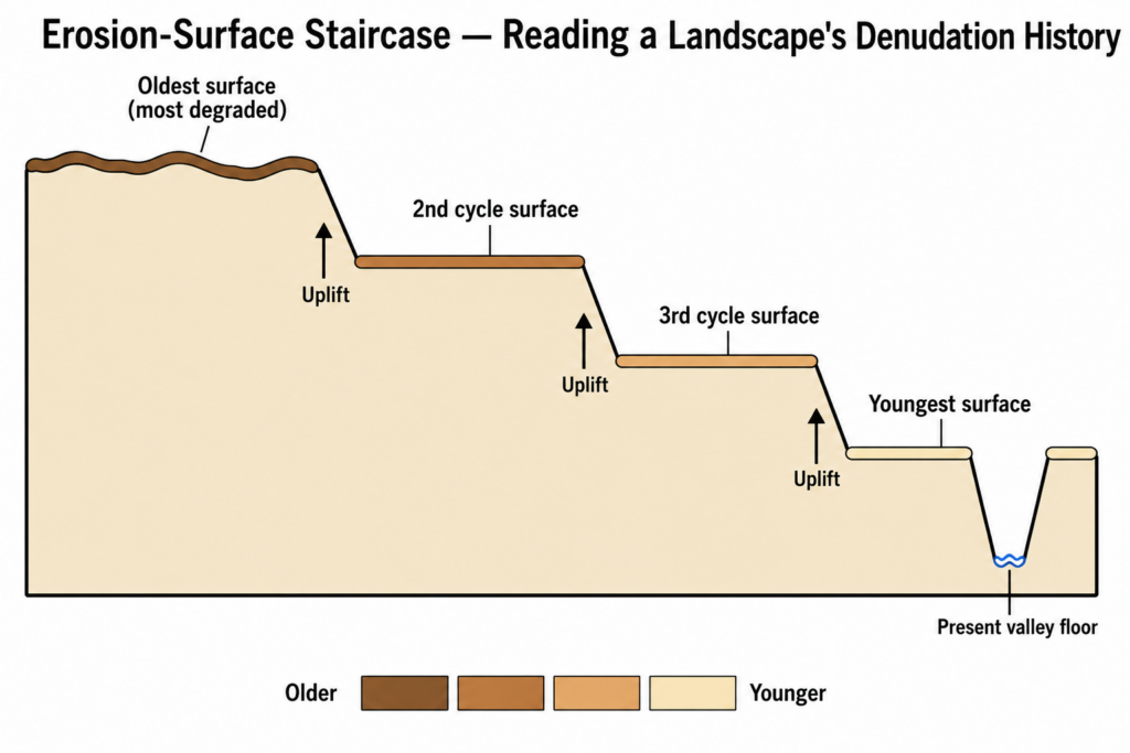
- It grew directly out of William Morris Davis’s geographical cycle (1899): if every uplift starts a new cycle, then a landscape interrupted several times should preserve the partial products of several cycles, one above the other.
- Its value is therefore methodological: it turns the spatial arrangement of relief into a temporal sequence of uplift, planation and rejuvenation events.
The Premises That Make Sequencing Possible
- Uniformitarianism — “the present is the key to the past”, the principle of James Hutton, popularised by Charles Lyell and phrased so by Archibald Geikie — lets present processes explain relict forms.
- Palimpsest topography: like a manuscript written, scraped and rewritten, an old landmass carries partly erased imprints of earlier cycles beneath its present form; few old landscapes record a single cycle.
- Erosion surfaces cut across structure: a true planation surface bevels hard and soft rocks, folds and faults alike, whereas a structural bench follows a resistant bed — the first test that a level is a genuine time-marker.
How the Method Builds a Sequence
- Relative order from elevation: each uplift or base-level fall starts a new cycle that cuts a younger surface at a lower level, leaving the older one as plateau remnants, benches or accordant summits above it — the highest, most dissected surface is normally the oldest.
- Drainage history fills the gaps between surfaces: knickpoints and waterfalls mark the head of the latest rejuvenation wave; superimposed and antecedent drainage, river capture, wind gaps and water gaps record the order in which surfaces were abandoned.
- Correlative deposits: the waste stripped from a rising highland accumulates in adjacent basins, often in a fining-upward sequence (conglomerate to clay) that records a cycle’s waning energy.
Anchoring the sequence in time
- Bracketing: the youngest rock a surface truncates gives its maximum age; the oldest deposit or lava resting on it gives its minimum age.
- Lester Charles King’s caution: a cover deposit dates only the end of a surface’s formation — he argued that Gondwana-age pediplain remnants in southern Africa had been wrongly assigned to the Tertiary merely because Miocene deposits rested on them.
- Radiocarbon reaches back only about 50,000 years, so pre-Quaternary surfaces now rely on 40Ar/39Ar dating of weathering minerals, apatite fission-track thermochronology and cosmogenic nuclides.
A Classic Demonstration: South-East England
- Sidney William Wooldridge and David Leslie Linton (1939) read the Weald and London Basin as a three-stage sequence: an exhumed sub-Eocene surface, a summit Mio-Pliocene peneplain, and a lower Plio-Pleistocene marine bench from which the present drainage was superimposed.
- David K. C. Jones (1999) later set this alongside three rival evolutionary models and found that all four were theoretically possible — the same staircase of levels could be sequenced in more than one way.
Application: Sequencing the Chotanagpur Highlands
- The classical reconstruction reads the plateau as a polycyclic palimpsest:
- Pre-Dalma surface — peneplanation after Archaean uplift and folding, interrupted by the Dalma lava; traces survive only as an unconformity beneath the Dhanjori sandstone-conglomerates.
- Pre-Cambrian surface — a dissected granite-gneiss surface, sealed by the Kolhan and Vindhyan sediments.
- Carboniferous glaciation — Talchir ice sheets modified the earlier relief.
- Permian-Triassic surface, then the Gondwana (pre-Tertiary) surface, the latter terminated and dated by the Deccan Trap lava.
- Tertiary uplifts (Miocene onward) raised the south-west by roughly 900 m in all and rejuvenated the rivers.
- The landforms follow the sequence: the flat-topped pats of the west (Netarhat about 1,100 m) are remnants of the oldest, uplifted pre-trap surface, their flat tops held up by a lava and laterite cap; the Ranchi surface (about 600–700 m) is a younger level; its rim is broken by knickpoint falls such as Hundru (Subarnarekha) and Dassam (Kanchi), marking the advancing Tertiary rejuvenation.
- Current confirmation from the Peninsula (2016): Nicolas J. Bonnet, Anicet Beauvais, Nicolas Arnaud, Dominique Chardon and Mudlappa Jayananda dated manganese-bearing laterites on palaeosurfaces either side of the Western Ghats by 40Ar/39Ar, showing intense weathering at about 53–45 Ma and 37–23 Ma, and that most dissection of the highland came after about 23 Ma — turning a relative staircase into dated episodes.
Where the Method Reaches Its Limits
- Fragmentary evidence: it explains directly only the surviving scraps of former surfaces; older surfaces are the most dissected and least legible.
- Non-unique interpretations: tilting and warping can make one surface appear as two, or two as one, which is why height correlation alone is distrusted.
- Base level is not only tectonic: eustatic sea-level change and climatic shifts also start new cycles, so not every bench records an uplift.
- The process critique: John Tilton Hack and Arthur Newell Strahler argued that landforms adjust continuously to process (dynamic equilibrium), so accordant levels need not record discrete stages; Stanley Alfred Schumm’s thresholds and episodic erosion soften, rather than abolish, cyclic sequencing.
- Judgement: denudation chronology remains the only method that reads relief as a dated historical archive — it explains why an ancient shield such as Peninsular India still shows several distinct erosional steps instead of one plain; its sequences are credible only where independent dating (lava covers, weathering-mineral ages, thermochronology) supports the elevation logic, which is how the method survives today.