

- A slope is the angular inclination of the ground between hill crests and valley floors (or between a cliff top and the shore), produced by the combined working of geological structure, rock type, climate, vegetation, relief and denudational processes.
- Except on plains and terraces, slopes are everywhere; a physical landscape is an assemblage of slopes, so slope study sits at the core of geomorphology.
- Hillslopes also supply water and sediment to streams within the drainage basin.
- The study of slopes has two linked parts: slope form (the morphology of a slope at a given time) and slope process (weathering, mass movement and erosion that change that form).
Slope: Meaning and Study
Slope Angle, Slope Profile and Characteristic Angle
- Slope angle: the angle of inclination of a surface, whether a hillslope or a valley-side slope.
- Slope profile: the inclined surface itself, traced from crest to base along the line of steepest descent.
- Characteristic angle: the angle that occurs most frequently on slopes of a given rock type under a given climate, the modal angle of a set of measured profiles.
- The idea was developed by Anthony Young (1961), who separated characteristic angles from limiting angles (the steepest angle a material can hold).
Phases of Slope Study
- Qualitative phase: slopes were interpreted from field observation and deduction.
- William Morris Davis (slope decline) and Walther Penck (slope replacement and parallel retreat) belong here.
- Quantitative phase (from about 1950): slopes are measured in the field, from topographic maps and aerial photographs, and their processes are instrumented.
- Key workers: Arthur Newell Strahler (1950), R. A. G. Savigear, Anthony Young and Stanley A. Schumm.
- Present phase: digital elevation models, LiDAR and cosmogenic-nuclide dating of soil production measure slope form and process over whole landscapes.
Slope Elements
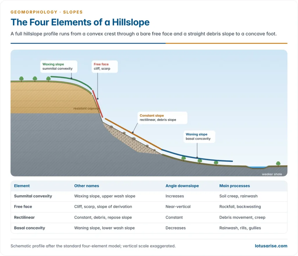
- A hillslope or coastal slope profiled from top to bottom is not uniform; it breaks into distinct segments called slope elements.
- Alan Wood (1942) set out the standard four-element profile, later adopted by Lester Charles King in his model of slope development:
- Waxing slope (summital convexity) at the top.
- Free face (cliff or scarp) below it.
- Constant slope (rectilinear or debris slope) below the free face.
- Waning slope (basal concavity) at the foot.
- The words waxing and waning go back to Walther Penck (1924), who described convex and concave slope forms as the products of waxing and waning development.
- These are elements of one profile, not separate kinds of slope; a real hillslope nearly always has more than one element, though one may dominate.
Summital Convexity (Waxing Slope)
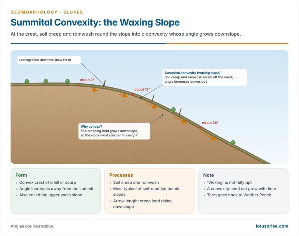
- The convex element at the hill crest; the slope angle increases downslope from the summit.
- Formed mainly by soil creep and rainwash, which round off the crest; hence also called the upper wash slope.
- Most typical of humid temperate and other soil-mantled slopes.
- The name waxing is not fully apt: a convexity does not always grow in height or size with time.
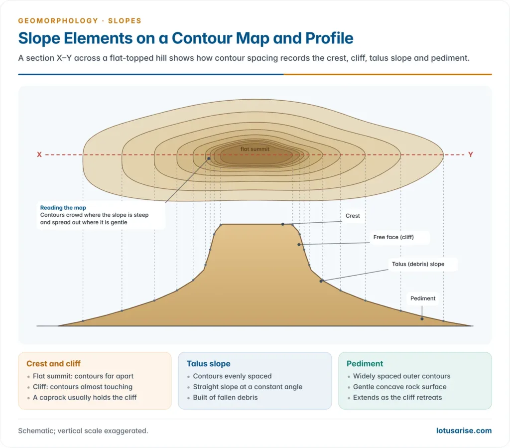
Free Face (Cliff or Scarp)
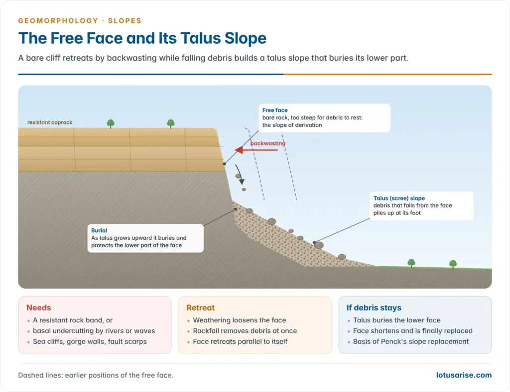
- A steep, wall-like face of bare rock, too steep for weathered debris to rest on.
- All loosened material falls or slides at once to the foot, so it is also called the slope of derivation.
- It needs either a resistant rock band (hillslopes) or basal undercutting by waves or rivers (coastal cliffs, gorge walls, glacial troughs, fault scarps).
- The free face is worn back by backwasting, which lets it retreat parallel to itself.
- Debris gathering at its foot builds a talus (scree) slope:
- As the talus grows upward it buries and protects the lower part of the free face.
- If the debris is not removed, the free face shortens and is finally replaced by a gentler depositional slope, the basis of Penck’s idea of slope replacement.
Rectilinear Element (Constant Slope)
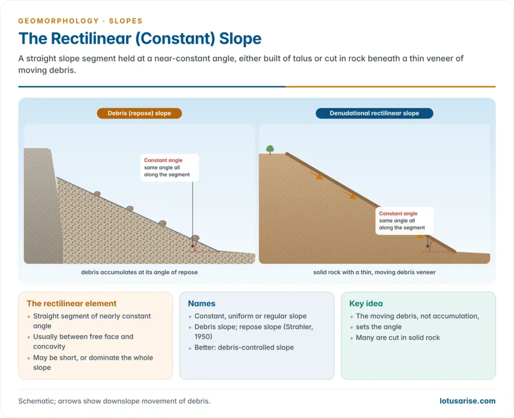
- The straight segment, usually between the free face and the basal concavity; its angle stays nearly constant, so it is also called a constant, uniform or regular slope.
- Its length varies greatly:
- It may be a short middle segment, or it may dominate the whole profile from summit to valley floor.
- Because it usually carries debris at or near the angle of repose, it is also called the debris slope; Arthur Newell Strahler (1950) termed such slopes repose slopes.
- The debris label can mislead: many rectilinear slopes are denudational, cut in solid rock with only a thin, mobile veneer of debris creeping downslope.
- Hence the preferred term debris-controlled slope: the moving debris, not accumulation, sets the angle.
Basal Concavity (Waning Slope)
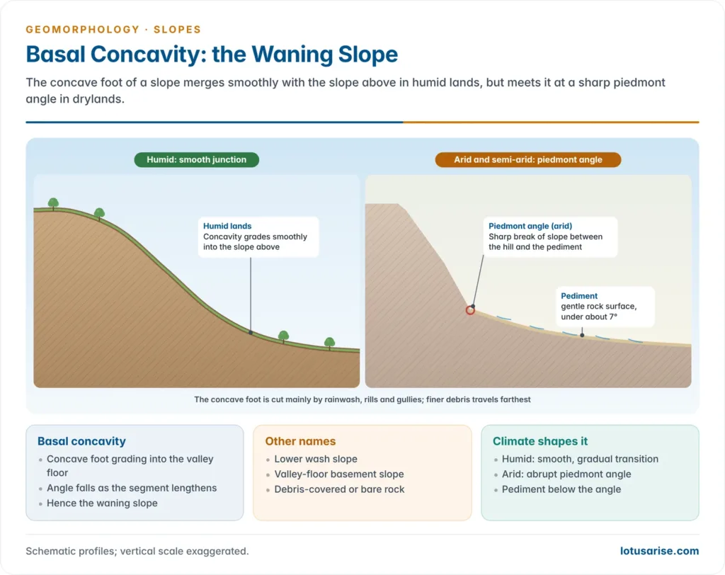
- The concave element at the foot, grading into the valley floor; the angle decreases as the segment lengthens, hence waning slope.
- Also called the lower wash slope or valley-floor basement slope.
- Formed mainly by rainwash, rill and gully erosion, with finer debris carried farther than coarse; it may be debris-covered or bare rock.
- Climate shapes the junction:
- In arid and semi-arid lands a sharp break of slope (piedmont angle) separates the concave pediment from the steep slope above.
- In humid lands the basal concavity grades smoothly into the slope above.
| Element | Other names | Angle downslope | Main processes | Surface |
|---|---|---|---|---|
| Summital convexity | Waxing slope, upper wash slope | Increases | Soil creep, rainwash | Soil-covered |
| Free face | Cliff, scarp, slope of derivation | Near-vertical | Rockfall, backwasting | Bare rock |
| Rectilinear | Constant, debris, repose slope | Constant | Debris movement, creep | Thin debris or rock |
| Basal concavity | Waning slope, lower wash slope | Decreases | Rainwash, rills, gullies | Debris or bare rock |
Why Elements Vary from Slope to Slope
- The full four-element profile is an ideal; which elements appear depends on rock type and structure, relief, climate, vegetation and process.
- A free face does not form where relief is low or subdued.
- Where resistant and weak beds alternate, free faces (on resistant beds) and rectilinear segments (on weak beds) repeat down the profile.
- Indian example: the escarpments of the Bhander plateau (Madhya Pradesh) show all four elements.
- Massive Vindhyan sandstones form a caprock and free face; the shales and mudstones beneath carry the rectilinear and concave segments, while the summital convexity is weak.
- The stepped trap topography of the Deccan basalts shows the repeated free face and debris slope pattern on successive lava flows.
- In the Davisian view the dominant element also changes with time: convexity in youth, rectilinearity in maturity, concavity in old age.
Composite Slope Profiles
- Since a mono-element slope is rare, most slopes are composite (compound) slopes. Three combinations are especially common:
- Convexo-rectilinear-concave profile: upper convexity, middle straight segment and lower concavity grading smoothly into one another.
- Typical of weak, homogeneous rocks under humid temperate climate, such as the clay and chalk lowlands of England.
- Alternating hard and soft rocks, or repeated rejuvenation, make the profile far more complex.
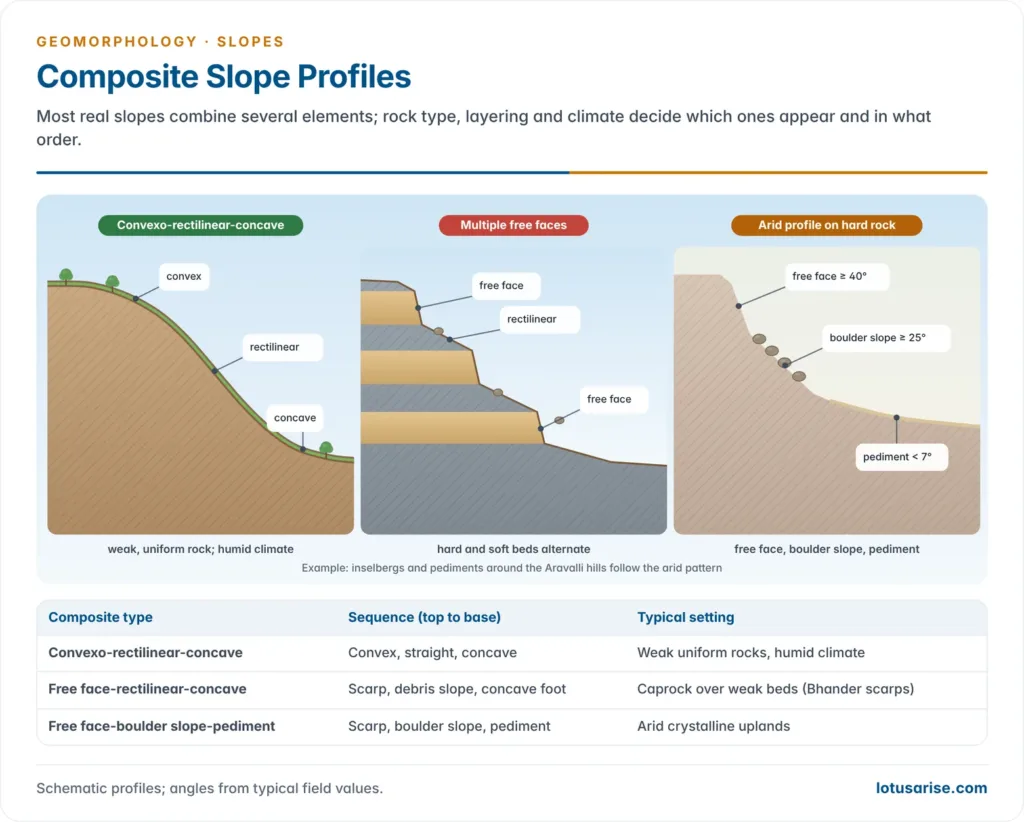
- Multiple free face and rectilinear profile: found where massive and thin-bedded strata alternate, relief is high, valleys are deep and weathering is active.
- Massive beds stand as free faces and thin weak beds weather back to rectilinear segments; the convexity and concavity are small or absent.
- Arid profile on hard crystalline rock: a free face above (about 40° or more), a boulder-controlled slope in the middle (about 25° or more, littered with boulders) and a concave pediment below (under about 7°).
- The inselbergs and pediments around the Aravalli hills of Rajasthan follow this pattern.
| Composite type | Sequence (top to base) | Typical setting |
|---|---|---|
| Convexo-rectilinear-concave | Convex, straight, concave | Weak uniform rocks, humid climate |
| Free face-rectilinear-concave | Scarp, debris slope, concave foot | Caprock over weak beds (Bhander scarps) |
| Convex-rectilinear-free face-rectilinear-concave | Two segments split by a scarp | Resistant band mid-slope |
| Convex-rectilinear-free face | Scarp at the base | Sea cliffs undercut by waves |
| Free face-boulder slope-pediment | Scarp, boulder slope, pediment | Arid crystalline uplands |
Classification of Slopes
- Slopes are often labelled convex, concave, rectilinear or cliff slopes, but these are elements, not types; a sound classification rests on genesis, stage of formation or measured angle.
Genetic Classification
- Endogenetic (tectonic) slopes: made by forces within the Earth.
- Faulting and tilting give fault scarps, rift-valley walls and tilted-block slopes; folding gives scarp and dip slopes.
- Denudation soon modifies them into compound slopes, as along the Western Ghats escarpment.
- Exogenetic slopes: made by weathering, mass wasting, erosion and deposition at or near the surface.
- Erosional (degradational) slopes: valley sides cut by rivers, glacial trough walls, sea cliffs, escarpments and river-terrace scarps.
- Depositional (aggradational) slopes, or slopes of accumulation: alluvial fans and cones, natural levees, moraines, sand dunes, beaches, bars and talus cones.
- Volcanic slopes combine both: the eruption is endogenetic, but cones and lava plateaus are built by accumulation of lava and pyroclasts and then reshaped by subaerial processes.
| Class | Formed by | Examples | Indian examples |
|---|---|---|---|
| Tectonic | Faulting, folding, tilting | Fault scarps, rift walls | Western Ghats scarp, Narmada rift margins |
| Erosional | Rivers, glaciers, waves | Valley sides, cliffs, troughs | Himalayan gorges, Konkan cliffs |
| Accumulation | Deposition by any agent | Fans, dunes, moraines, talus | Bhabar fans, Thar dunes |
| Volcanic | Lava and pyroclast build-up | Cones, lava plateaus | Barren Island cone, Deccan trap scarps |
Primary and Secondary Slopes
- Primary slopes: made directly by erosion or tectonics: V-shaped valley sides, gorge and canyon walls, sea cliffs, U-shaped trough walls and fault scarps.
- Secondary slopes: minor slopes at the base of primary slopes, formed by weathering, surface wash and accumulation, such as talus cones built by scree from above (common along Himalayan roads and valleys).
Quantitative Classification
- Slopes are also classed by measured angle, from maps, aerial photographs or field instruments; Anthony Young grouped them into seven classes.
| Class | Angle | Sub-classes |
|---|---|---|
| Level to very gentle | 0°–2° | Level 0°–0.5°; almost level 0.5°–1°; very gentle 1°–2° |
| Gentle | 2°–5° | — |
| Moderate | 5°–10° | — |
| Moderately steep | 10°–18° | — |
| Steep | 18°–30° | — |
| Very steep | 30°–45° | — |
| Precipitous to vertical | 45°–90° | Precipitous 45°–70°; wall-like 70°–90° |
Approaches to the Study of Slope Development
- The problems geomorphologists face include:
- the variety of forms and the fact that most slopes are compound and three-dimensional;
- the denudation balance of a slope and its change of form and gradient with time;
- whether slopes retreat parallel or decline;
- the role of mass movement, structure, lithology and climate in shaping slopes.
- Theoretical, experimental and empirical (field) work on these problems falls into two broad approaches.
Slope-Evolution (Historical) Approach
- Traces the history of a slope from its initial form to the present.
- Difficulties:
- Initial form is unknown: most workers assumed an original vertical cliff that weathered back, but most slopes border river valleys that were never cliffs, and weathering and creep modify river-cut slopes as they form.
- Dating is hard: slopes are put into a relative time sequence by comparing many field profiles (space-for-time substitution).
- The sequence breaks down where rejuvenation has produced incised meanders, since upper valley-side segments are older than lower ones.
- Views within it differ:
- Davis: slopes decline from steep in youth to gentle and concave in old age.
- Walther Penck and Lester Charles King: many slopes keep their angle by parallel retreat.
- Dynamic equilibrium (John T. Hack, 1960): slope form adjusts to process and is largely time-independent.
Process-Form Approach
- Rests on a causal link between slope form and the processes of weathering, erosion, transport and deposition; their combination and rate, set by rock, climate, vegetation and relief, decide the form.
- Example: in a humid climate, limestone favours soil creep and a convex slope, since its porosity weakens surface wash, while clay suffers intense rainwash and develops concave slopes.
- Difficulties:
- Slope processes are very slow and hard to measure, needing precise instruments and long records.
- Not every process on a slope shapes it; creep and wash move weathered regolith, not solid rock.
- Many present slopes are relict forms of past processes and climates; the link is firmest on soft, actively eroding rocks.
- If process controls form, form should vary with climate; but pediments, once thought purely arid, occur in subhumid tropical and humid temperate lands too, and all four elements occur in most climates except the periglacial.
- This led King to his idea of climatic uniformitarianism.
| Aspect | Slope-evolution approach | Process-form approach |
|---|---|---|
| Question | How has the slope changed over time? | Which processes make this form now? |
| Method | Deduction, relative dating of profiles | Field measurement, process instruments |
| Time | Central (sequence of stages) | Secondary (form in equilibrium) |
| Associated with | Davis, Penck, King | Strahler, Young, Hack |
| Weakness | Speculative initial form, poor dating | Slow processes, relict forms |
Processes and Slope Form
Controls of Slope Form
- No single factor explains slope form; it results from structure, rock type, dip, vegetation, weathering type, mass movement, earth movements and relief, though one may dominate locally.
- The main slope-forming processes are:
- creep (soil creep, solifluction, debris creep);
- slides and flows (debris slides, earth flows, debris and mud flows);
- slope erosion by rain splash, overland flow, rainwash, rills and gullies.
Mono-Process Concepts
- Hold that one dominant process produces a distinctive form, typically convexity by creep and concavity by wash.
- Nevin Melancthon Fenneman (1908): convexo-concave slopes result from unconcentrated wash.
- Near the crest runoff is a thin sheet with little water, so erosion is weak and the top is only rounded.
- Downslope runoff accumulates and concentrates into rills and gullies, so erosion peaks at the base and carves a concavity.
- Weakness: it ignores soil creep, dominant in humid regions where much rain infiltrates, which also reduces the runoff he relied on.
- Robert E. Horton (1945) supported Fenneman: next to the divide lies a belt of no erosion where sheet flow lacks the energy to erode; this matches the flatter crest, and erosion by wash begins only beyond it.
- Grove Karl Gilbert (1909): the convexity of hilltops is due to soil creep.
- The amount of creeping soil that must pass each point increases downslope, so the slope must steepen downslope to carry it; the result is a convex profile.
- Weakness: it assumes a permanently mobile soil cover, and heavy transport would pile debris at the base, making it concave.
- Andrew Cowper Lawson (1932): rainwash is most effective near the crest, where runoff is underloaded and so has spare energy.
- The crest becomes a zone of erosion (convex); downslope the runoff is overloaded, so the base becomes a zone of aggradation (concave); relief and slope angles decline with time, much as Davis envisaged.
- Weakness: strong erosion by little water at the top and none by more, faster water below is hard to accept; most basal concavities are erosional, cut by rills and gullies.
| Worker | Main process | Convexity explained by | Concavity explained by |
|---|---|---|---|
| Fenneman (1908) | Rainwash | Weak wash near crest | Strong wash and gullying below |
| Horton (1945) | Overland flow | Belt of no erosion near divide | Erosion beyond critical distance |
| Gilbert (1909) | Soil creep | Downslope rise in creeping load | — |
| Lawson (1932) | Rainwash | Strong wash by underloaded flow | Deposition by overloaded flow |
Poly-Process Concept
- Henri Baulig (1940) rejected “one process, one form”: several processes act on a slope, each dominant on a different segment.
- On humid temperate convexo-concave slopes, creep dominates the upper segment and forms the convexity; wash, rills and gullies dominate the lower segment and form the concavity.
- As relief falls, creep slows while wash continues, so the concavity extends upslope until it covers most of the slope.
- In reality most processes act together on the same segment with varying intensity, so the poly-process view is closer to nature.
- Some geomorphologists treat creep and wash not as slope-forming but as agents that transport the debris weathering produces.
Current View
- Slope form is now explained by a mass balance: the change in soil and rock on each part of a slope equals what is produced by weathering minus the divergence of sediment flux.
- William E. H. Culling (1963) treated creep as diffusion, with flux proportional to gradient; this yields convex hilltops and puts Gilbert’s idea on a quantitative footing.
- Michael J. Kirkby (1971) showed that diffusive processes (creep, splash) make convexities, while wash, whose flux grows with distance from the divide, makes concavities; the balance between them fixes where the convexity passes into the concavity.
- Studies from the late 1990s show creep becomes nonlinear, rising sharply as gradient approaches a threshold; hence steep slopes become straight, limited by landsliding, as the rectilinear element suggests.
- Transport-limited slopes (soil-covered, rounded) are distinguished from weathering-limited slopes (bare rock, cliffs), which explains why free faces form on resistant rock.
Models of Slope Evolution
- All theories of slope development fall into three groups (Anthony Young, 1972): slope decline, slope replacement and parallel retreat.
| Model | Proponent | Change of slope with time |
|---|---|---|
| Slope decline | William Morris Davis | Steepest part lowers; convexity and concavity spread |
| Slope replacement | Walther Penck | Gentler segments grow upward and replace steeper ones |
| Parallel retreat | Alan Wood, Lester Charles King | Free face and debris slope retreat at constant angle; pediment extends |
Slope Study in India
- Slope failure is India’s commonest hill hazard, so slope analysis now serves hazard mapping and slope management.
- The Landslide Atlas of India (NRSC–ISRO, 2023) maps about 80,000 landslides of 1998–2022, concentrated in the Himalaya, the North-East and the Western Ghats.
- The Geological Survey of India has mapped landslide susceptibility over about 4.3 lakh sq km and runs a regional landslide early warning system for selected districts.
- Recent events: Joshimath (Uttarakhand), built on old landslide debris on a steep slope, suffered severe land subsidence in January 2023; debris flows in Wayanad (Kerala) on 30 July 2024 killed more than 200 people.
- Both show how cutting slope toes, loading slopes and blocking drainage destabilise slopes.





👍🏻
sir if we look at past questions they were from historical approach of slope development which includes views of Davis, penck, and king.
please make addition of their views regarding slope dev. such as slope decline of Davis and slope replacement of penck and parallel retreat of king.
Hey Abhishek if I can ask you something.
Are these notes enough for geo optional?
sir/mam, can you please include pyq in their respected topics/themes
Okay
Follow synopsis free resources