

“The knowledge of slope analysis has limited field application in the slope management.” Explain. (2017)
- Slope analysis is the geomorphic study of slope form — measuring slope angles and profiles, mapping them, and explaining how they evolve.
- Slope management is the practical task of keeping slopes stable — protecting roads, settlements, reservoirs and farmland from landslides, rockfalls and erosion.
- The statement holds because slope analysis describes what a slope looks like and how it evolved over geological time, while management needs to know whether, how and when it will fail in the next few years.
What Slope Analysis Offers
- Slope mapping: Chester K. Wentworth (1930) devised a method of estimating average slope from contour crossings on a grid; Erwin Raisz and Joyce Henry (1937) produced average-slope maps — the basis of slope-category maps used in terrain classification.
- Profile analysis: Alan Wood (1942) divided an ideal hillslope into a waxing (convex) slope, free face, constant (debris) slope and waning (concave) slope; Lester C. King (1953) built this standard hillslope into his model of parallel retreat.
- Statistical analysis: Arthur N. Strahler (1950) treated slope angle as a measurable variable and used angle-frequency distributions, showing that slopes on a given rock type under a given climate cluster around a characteristic mean angle.
- Evolutionary models: William Morris Davis (slope decline), Walther Penck (slope replacement) and Lester C. King (parallel retreat) explained how slopes change over 10⁵–10⁶ years.
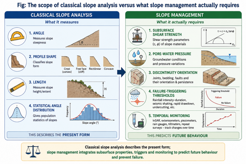
Why Its Field Application Is Limited
- Form does not measure stability: engineers judge a slope by its factor of safety — resisting shear strength divided by the shear stress driving failure, with failure expected below 1.
- Shear strength follows the Mohr–Coulomb relation (τ = c′ + (σ − u) tan φ′), so it needs cohesion, friction angle and pore-water pressure — none of which a slope-angle survey records.
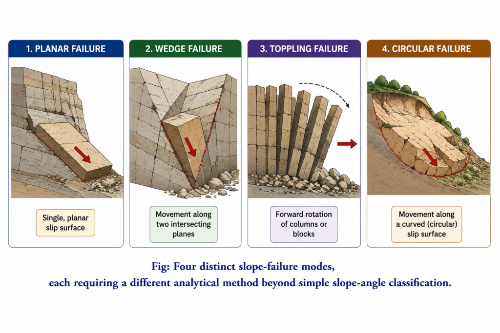
- Failure mode is set by structure, not angle: the same angle can fail by planar sliding, wedge failure, toppling or rotational (circular) failure, depending on joints, bedding and weathering; each needs a different analysis.
- Triggers are dynamic: rainfall raises pore pressure, earthquakes shake, rivers and road cuttings undercut the toe. A slope can keep its form for years while its safety factor falls — form cannot tell when it will fail.
- Timescale mismatch: the classical models deal with landscape change over hundreds of thousands of years; management works over years and decades. The three classical models still disagree precisely because the slow processes linking process to form are hard to observe.
- Scale mismatch: slope maps classify whole regions, but retaining walls, drainage works, rock bolting and bio-engineering are designed for one slope or one slip surface.
- Idealised profiles: real slopes are heterogeneous in lithology, weathering depth, vegetation and human cuts, so one profile type groups slopes that behave quite differently.
Where Slope Analysis Does Reach the Field
- Hazard zonation starts with slope: the Geological Survey of India has completed National Landslide Susceptibility Mapping at 1:50,000 for about 4.3 lakh sq km across parts of 19 states and union territories, combining slope with lithology, structure, land use and rainfall; since the 2025 monsoon it has issued landslide forecast bulletins for 21 districts in eight states.
- The Landslide Atlas of India (2023) mapped about 80,000 landslides between 1998 and 2022, and about 12.6 per cent of India’s land area outside snow cover is landslide-prone — slope is the first filter in deciding where detailed work is needed.
- Bridging tools exist: Michael J. Selby (1980) devised a rock mass strength classification that relates slope angle to rock strength and jointing, so a geomorphic survey yields a stability judgement.
- The gap is also institutional: at Joshimath, a 1976 government committee had warned that the town stood on old landslide debris; the subsidence crisis of early 2023 showed geomorphic knowledge ignored rather than absent.
Conclusion
- Slope analysis tells the manager where to look — which slopes are steep, which elements are active, which terrain classes are susceptible.
- It cannot alone tell what to do — that needs boreholes, shear-strength tests, piezometers, inclinometers and satellite (InSAR) monitoring of movement.
- Judgement: the statement is largely valid for classical, form-based slope analysis, but it understates the field role of modern slope analysis — integrated with geotechnical data in susceptibility mapping and early warning, slope analysis is the indispensable first step of slope management, not a substitute for it.