“Discuss the role of Slope, Altitude and Relief (SAR) in landscape development.” (2022)
- Slope, Altitude, and Relief (SAR) are three interlinked morphometric properties of the land surface that together govern how a landscape is sculpted: slope determines the local direction, rate, and mechanism of denudation; altitude introduces a vertical, climate-controlling dimension that sets which processes operate at a given point at all; and relief — the vertical range between a landscape’s highest and lowest points — sets the total energy available for erosion and the pace at which the whole system can evolve.
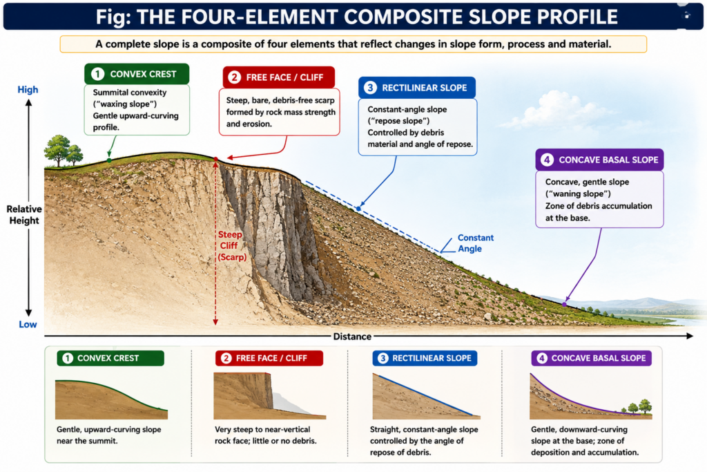
- The intellectual scaffolding for treating slope as central to landscape development comes from L.C. King and A. Wood’s four-element composite slope-profile model (crest, free face, rectilinear, and basal concave slope), Walther Penck’s dynamic “waxing” and “waning” slope terminology, and A.N. Strahler’s statistical, process-based treatment of slope as a quantifiable variable — while altitude and relief find their fullest treatment in the climatic-geomorphology and denudation-chronology traditions that trace how a landscape’s vertical dimension conditions everything from weathering regime to the pace of the geomorphic cycle.
- The thesis argued here: SAR are not three independent variables acting in isolation but a single, mutually-reinforcing control system — relief supplies the potential energy for denudation, altitude determines which climatic and process regime acts on that relief, and slope is the surface on which the resulting processes are actually expressed — so that landscape development at any location can be read as the continuously evolving outcome of these three factors working together.
Slope: The Surface on Which Denudation Is Expressed

- Slope is best understood through the process-form approach: the form and gradient of a slope is the outcome of a causal relationship between weathering, erosion, transportation, and deposition operating at different combinations and rates, so that the resulting profile is a direct physical record of which denudational processes have dominated.
- King and Wood’s standard composite slope profile identifies four recurring elements: the convex crest at the summit (shaped chiefly by weathering and soil creep, and termed the “waxing slope” by Penck because its angle increases downslope); the free face or cliff, a steep, bare scarp kept clear of debris by continuous rockfall; the rectilinear or constant slope, a debris-controlled “repose slope” (Strahler’s term) lying at the material’s angle of rest; and the basal concave slope, or Penck’s “waning slope,” built up by fine debris spread by rainwash and mass movement toward the valley floor.
- “The concept of an initial slope is perhaps a totally unrealistic one” — Small (1978), a reminder that slope form is never a fixed starting condition but a continuously evolving response to ongoing process.**
- Slope angle and profile directly determine which geomorphic cycle model best describes a landscape’s evolution: Davis’s normal cycle assumes progressive slope decline (angles steadily flatten with time), Penck’s model assumes slope replacement (steeper elements are progressively replaced by gentler ones migrating up-slope), and King’s arid-cycle model assumes parallel slope retreat (the free face retreats backward at a near-constant angle, extending a pediment at its base) — three fundamentally different landscape trajectories, each rooted in a different assumption about how slope itself behaves through time.
- Because slope directly governs surface runoff velocity, infiltration, and the gravitational component of mass movement, it is the primary local control on erosion rate, drainage density, and the choice between fluvial and mass-wasting-dominated denudation — steep slopes favour rapid mass movement and high-energy channel incision, while gentle slopes favour sheet wash, infiltration, and slower, more chemically-dominated weathering.

Altitude: The Vertical Control on Process Regime
- Altitude introduces the vertical zonation of climate, and through climate, the zonation of the geomorphic processes that actually operate at a given elevation: the environmental (adiabatic) lapse rate lowers temperature by roughly 6.5°C per 1,000 m of ascent, so that a single mountain slope can pass through several distinct process zones between its base and summit.
- This produces a recognisable altitudinal sequence of geomorphic zones on high mountains: a fluvial/denudational zone at the base dominated by running water and chemical weathering; a periglacial zone at intermediate elevations where repeated freeze-thaw cycles drive frost-shattering, solifluction, and the formation of altiplanation terraces and block fields; and a nival/glacial zone above the snowline, where ice accumulation and glacial erosion (cirques, arêtes, horns) take over as the dominant landform-building process.
- Altitude also governs the snowline and permafrost limit directly, and shifts in these limits — whether from long-term climatic change or from local relief blocking or channelling moisture — are directly recorded in the landforms left behind, such as relict periglacial features (fossil solifluction lobes, patterned ground) now found well below the modern altitudinal zone that would produce them, indicating past colder climates at lower elevations.
- Beyond climate, altitude affects denudation more subtly through its influence on vegetation cover and rock exposure: high-altitude zones typically have sparser vegetation and more exposed bare rock, increasing the efficiency of mechanical weathering (frost action, exfoliation from pressure release) relative to the chemical weathering that dominates in the warmer, better-vegetated lowlands — a distinction directly visible in the contrast between the angular, frost-shattered summit ridges and the smoother, deeply weathered lower slopes of most high mountain ranges, including the Himalaya.
Relief: The Energy Budget for Landscape Development
- Relief — most simply the vertical interval between the highest and lowest points in a defined area (also expressed as “relative relief” when mapped over a standard grid) — determines the total potential energy available to the denudational system, since the rate of erosion by running water, ice, and mass movement is fundamentally a function of the gradient between a point and its local base level.
- High relief is associated with steep channel gradients, high stream power, deep and rapid incision, high drainage density, and a strong tendency toward mass wasting — the classic signature of tectonically active, recently uplifted mountain terrain such as the Himalaya, where relief of several kilometres over short horizontal distances drives some of the highest denudation rates measured anywhere on Earth.
- Low relief, by contrast, produces gentle gradients, sluggish or meandering rivers, low stream power, and a landscape dominated by lateral rather than vertical erosion — the terminal condition Davis described as the peneplain, King described as the pediplain, and which any sufficiently long-lived, tectonically quiescent landscape tends toward regardless of which specific cyclic model is invoked.
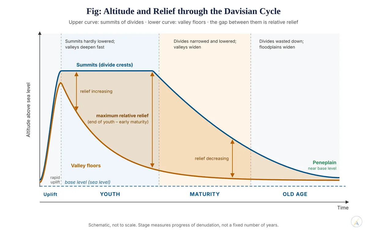
- Relief also interacts directly with base level: the greater the initial relief above base level, the longer the time required for a landscape to be reduced to a low-relief end-form under any of the cyclic models, which is why relief is used by geomorphologists as a first-order proxy for the relative “age” or stage of landscape development in denudation-chronology studies, and why maps of relative relief are a standard tool in regional geomorphological classification.
SAR as an Integrated System: Landscape Development Through Time

- SAR do not act as independent inputs but as a single, self-adjusting system: an increase in relief (via tectonic uplift) steepens slopes and extends the altitudinal range across which climatically distinct process zones operate, which in turn accelerates denudation, which progressively reduces relief, moderates slope angles, and compresses the altitudinal zonation back down — a negative feedback loop that is the physical basis of every cyclic model of landscape evolution from Davis onward.
- This integration explains why the same rock type and climate can produce dramatically different landscapes depending on relief and altitude alone — a limestone outcrop in a low-relief lowland develops gentle karst with subdued dolines, while the same limestone raised into a high-relief, high-altitude setting (such as parts of the Himalaya) develops steep karst with active periglacial modification of its surface forms, demonstrating that SAR, not lithology alone, often decides the actual expression of a given geomorphic process.
- The practical value of treating SAR together is reflected in modern geomorphological regionalisation studies, which routinely classify terrain using digital elevation models by combining slope-angle distribution, relative relief, and hypsometric (altitude-area) data as the primary variables — a direct, technologically updated continuation of the same three-factor logic that King, Wood, Penck, and Strahler articulated for slope, and Davis for the cyclic reduction of relief, decades earlier.
- Slope, altitude, and relief are best understood as three faces of a single control system governing landscape development: relief provides the gravitational energy budget, altitude determines which climatic and process regime acts upon that energy, and slope is the physical form through which the resulting denudation is expressed and continuously readjusted.
- Every classical model of long-term landscape evolution — Davis’s slope decline, Penck’s slope replacement, King’s parallel retreat — is, at its core, a theory about how relief-driven energy reshapes slope angle over time, while the altitudinal zonation of climate ensures that a single landmass can display fluvial, periglacial, and glacial landform assemblages simultaneously, purely as a function of elevation.
- Because SAR interact as a self-adjusting system rather than as separate variables, reading any landscape correctly — from a single hillslope to an entire mountain range — requires assessing slope, altitude, and relief together, which is precisely why they remain a foundational analytical triad in both classical denudation chronology and modern quantitative geomorphology.