

- An urban settlement is a settlement with a large population, high density and a workforce engaged mainly in secondary and tertiary activities such as manufacturing, trade and services.
- What counts as urban differs between countries; India’s Census uses legal status and the 5,000 / 400 per km² / 75% tests, that underlie the general classification of settlements.
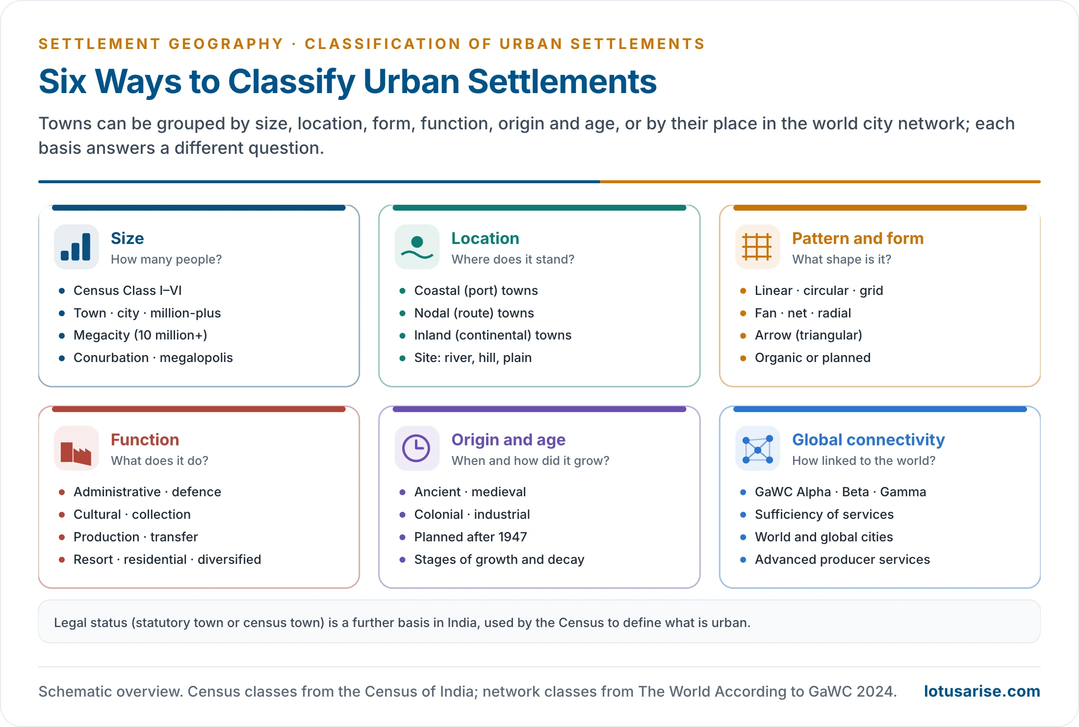
- Urban settlements are classified on several bases: size, location, pattern (form), function, origin and age, and, for the largest cities, their connectivity in the world economy. No one basis is complete; together they describe what a town is, where it stands, how it looks, what it does and how it grew.
Classification by Size

The Size Ladder
- Size is the simplest and most widely used basis, because population counts exist for every place.
- The common categories, from small to large, are town, city, metropolitan city, megacity, conurbation and megalopolis. The thresholds differ between countries and agencies.
Town
- A settlement larger than a village and smaller than a city.
- In India it has an urban local body (a municipality, nagar panchayat, notified area or cantonment board), or it qualifies as a census town. Most Indian towns have between 5,000 and 1 lakh people (Census Classes II–VI).
- Size alone does not make a town. Its functions do:
- A common textbook range is 2,000–20,000 people, which varies by country. India’s multi-factor tests guard against over-counting “urban” population.
- small-scale manufacturing and repair;
- retail and wholesale trade, a periodic or daily market;
- professional services (doctors, lawyers, banks) and schools;
- often the headquarters of a tehsil or block.
- Examples: Titabar (Assam), Etah (Uttar Pradesh), Solan (Himachal Pradesh).
City
- A large, permanent and administratively important settlement, the leading place of its region. Lewis Mumford saw the city as the physical form of the most complex kind of shared human life.
- In India a town of 1 lakh or more people is a city (Class I).
- Features:
- major transport terminals (railway stations, bus depots, airports);
- regional offices, courts and financial institutions;
- specialised hospitals, colleges and universities;
- a central business district and differentiated residential areas.
- Examples: Jhansi, Mysuru, Amritsar, Coimbatore.
- Other countries set different thresholds: Japan, for example, requires 50,000 people for city (shi) status, and China 1,00,000.
Metropolitan City
- A very large city that dominates a wide metropolitan region of suburbs, satellite towns and commuter zones.
- India’s 74th Constitutional Amendment (1992) defines a metropolitan area as one with 10 lakh (1 million) or more people, spread over one or more districts and two or more municipalities or panchayats.
- In common Indian usage, the 52 million-plus urban agglomerations of Census 2011 (final tables; 53 in the provisional count) are the metropolitan cities.
- The usual band is 10–50 lakh; larger cities were once treated separately as mega cities.
- Features: a multi-sector economy (industry, IT, finance, trade), major airports and inter-city rail, universities and research institutions, and heavy in-migration.
- Examples: Lucknow, Pune, Ahmedabad, Surat, Kochi, Jaipur.
- As they grow, metropolitan cities spread into wider conurbations and metropolitan regions such as the NCR and the Mumbai Metropolitan Region.
Megacity
- A city of 10 million or more people (UN definition; also the Census of India’s “mega city”).
- Older usage in India drew the line at 5 million, which took in Hyderabad, Chennai and Bengaluru.
- Census 2011: India had three mega urban agglomerations: Greater Mumbai (18.4 million), Delhi (16.3 million) and Kolkata (14.1 million).
- UN World Urbanization Prospects 2025:
- The number of megacities rose from 8 in 1975 to 33 in 2025; 19 are in Asia.
- Jakarta (about 42 million) is now the world’s most populous city, followed by Dhaka (about 37 million) and Tokyo (33 million).
- India has five: Delhi (30.2 million), Kolkata (22.5 million), Mumbai (20.2 million), Bengaluru (13.2 million) and Chennai (11.2 million).
- By 2050 the count is projected to reach 37, adding Addis Ababa, Dar es Salaam, Hajipur (India) and Kuala Lumpur.
- These figures use a new harmonised definition, so Jakarta and Dhaka appear far larger than their administrative limits suggest.
- Megacities produce a disproportionate share of national output and host national headquarters, stock exchanges, media and culture. They also face:
- housing shortages and the growth of slums and informal settlements;
- traffic congestion and severe air pollution;
- pressure on water supply, sanitation and waste services;
- flooding and heat stress, worsened by the loss of wetlands and green cover;
- sharp inequality between rich and poor neighbourhoods, and fragmented governance across many local bodies.
- Small and medium cities still house more people than megacities, and they are growing fast in Africa and Asia.
Conurbation and Megalopolis
- A conurbation forms when neighbouring towns grow until their built-up areas merge into one continuous urban and industrial area.
- The term was coined by Patrick Geddes in Cities in Evolution (1915).
- Examples: the West Midlands (Birmingham, Wolverhampton, Coventry), Rhine–Ruhr (Cologne, Dortmund, Essen, Düsseldorf), the Randstad (Amsterdam, Rotterdam, The Hague, Utrecht), Greater London, and in India the National Capital Region around Delhi and the Mumbai–Thane–Kalyan belt.
- A megalopolis is a chain of metropolitan areas joined by transport corridors over hundreds of kilometres.
- Older figures for its size vary, from over 5–10 million to 25 million and more.
- Jean Gottmann (1961) coined the term for the north-eastern seaboard of the USA, Boston to Washington (BosWash), about 700 km long (960 km if taken from north of Boston to Norfolk, Virginia), now home to over 50 million people.
- Other examples: Japan’s Tokaido (Taiheiyo) Belt (Tokyo–Nagoya–Osaka) and China’s Pearl River Delta, which the World Bank (2015) named the world’s largest urban area.
- Emerging Indian corridors: Delhi–Meerut–Agra, Mumbai–Pune and the Kolkata–Hugli belt.
| Category | Size threshold | Indian examples | World examples |
|---|---|---|---|
| Town | Below 1 lakh (India) | Etah, Solan, Titabar | Market towns everywhere |
| City | 1 lakh and above (India) | Jhansi, Mysuru, Amritsar | Cambridge, Bern |
| Metropolitan city | 10 lakh and above | Pune, Ahmedabad, Lucknow | Lyon, Melbourne |
| Megacity | 10 million and above | Delhi, Mumbai, Kolkata | Tokyo, Jakarta, Dhaka |
| Conurbation | Merged built-up area of several towns | NCR, Mumbai–Thane | West Midlands, Ruhr |
| Megalopolis | Chain of metropolitan regions | Delhi–Agra corridor (emerging) | BosWash, Tokaido belt |
- Merits of size as a basis: data exist for every place, the classes are easy to compare over time, and size is closely tied to the range of services a town offers.
- Limits: thresholds are arbitrary and differ between countries; size says nothing about function, form or growth; and results change with the unit counted (municipal town, agglomeration or metropolitan region).
Census Size Classes in India
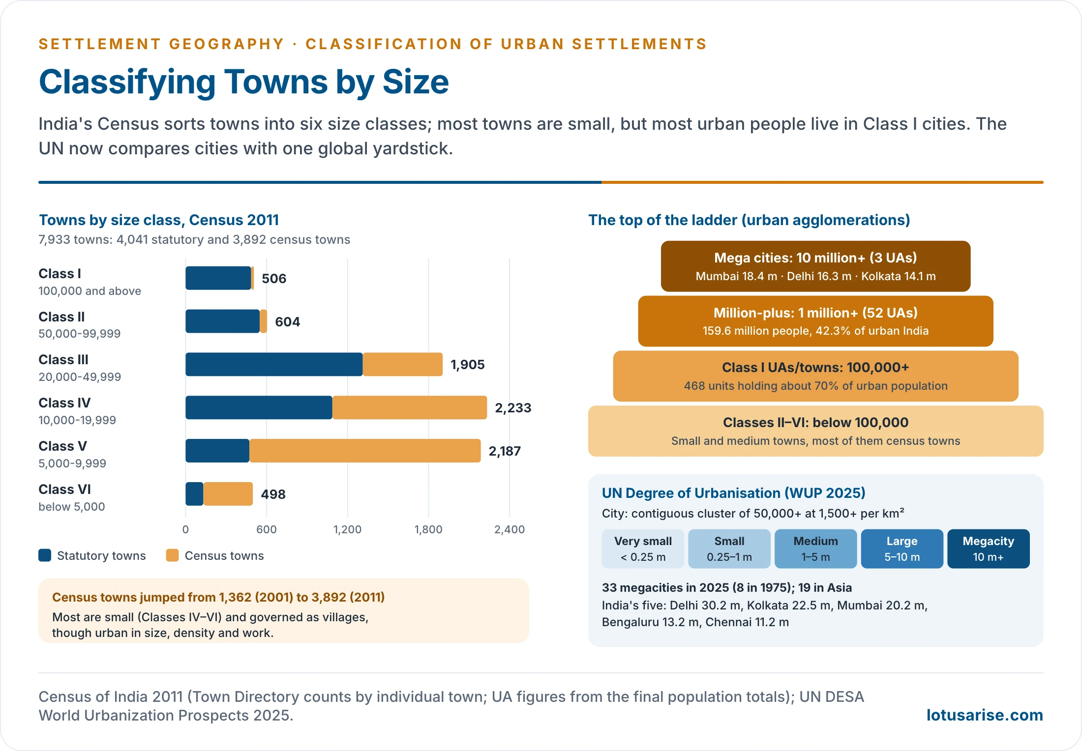
- The Census of India groups towns into six size classes. Counted town by town (Census 2011 Town Directory), they are as below; counted with each urban agglomeration as one unit, the totals are smaller (for example 468 Class I units).
| Class | Population | Towns, 2011 | Of which census towns |
|---|---|---|---|
| I | 1,00,000 and above | 506 | 20 |
| II | 50,000–99,999 | 604 | 54 |
| III | 20,000–49,999 | 1,905 | 592 |
| IV | 10,000–19,999 | 2,233 | 1,146 |
| V | 5,000–9,999 | 2,187 | 1,714 |
| VI | Below 5,000 | 498 | 366 |
| Total | 7,933 | 3,892 |
- The Census also uses unit categories for counting large cities:
- Urban agglomeration (UA): a continuous urban spread made of a town and its outgrowths, or two or more contiguous towns with or without outgrowths. Census 2011 recognised 475 UAs.
- Outgrowth (OG): a village or part of a village next to a statutory town with clear urban features (pucca roads, electricity, tap water, drainage, schools), counted with the town.
- Million-plus UA: a UA or city of 10 lakh or more; mega city: 10 million or more.
- Census 2011 counted 7,933 towns: 4,041 statutory towns and 3,892 census towns.
- The definition has changed. In 1901 a town was a municipality, civil lines, cantonment or other place of at least 5,000 chosen by the census superintendent. In 1911 princely capitals were added, and in 1951 many were removed. The stricter three-test form dates from 1961. In 1981 fishing, livestock, logging, plantations and orchards were left out of non-agricultural work, and in 2011 the test moved to male main workers.
- Census towns in 2011 were picked from villages of 4,000 or more in 2001 that met the density and work tests.
- Census towns nearly trebled from 1,362 in 2001. Most are small (Classes IV–VI) and are still governed by gram panchayats, though urban in size, density and work.
- Counted as urban agglomerations (a town with its outgrowths, or several contiguous towns):
- 468 Class I UAs/towns hold about 70% of India’s urban population.
- 52 million-plus UAs (final tables) hold about 159.6 million people (42.3%).
- 3 mega cities (10 million+) stand at the top.
- The size classes show the top-heavy character of Indian urbanisation: a few large cities hold most urban people, while thousands of small towns grow slowly. This pattern shapes the urban hierarchy and the debate on primate cities.
- India’s next census has its population enumeration on a reference date of 1 March 2027; until its results appear, 2011 remains the latest count of towns by class.
International Comparison
- National thresholds for “urban” range widely:
- Denmark and Norway: a cluster of just 200 inhabitants.
- United States (2020 Census): at least 5,000 people or 2,000 housing units in a densely settled area.
- Japan: 50,000 for city status.
- India: statutory status, or the census-town tests of population, density and non-farm work.
- National definitions of “city” vary so much that raw comparisons mislead. The UN Degree of Urbanisation, endorsed by the UN Statistical Commission and used in World Urbanization Prospects 2025, applies one yardstick:
- City: a contiguous cluster of at least 50,000 people at 1,500 or more per km².
- Town: a cluster of at least 5,000 people at 300 or more per km².
- Size bands: very small (below 2.5 lakh), small (2.5 lakh to 1 million), medium (1–5 million), large (5–10 million) and megacity (10 million+).
- On this basis cities hold 45% of the world’s 8.2 billion people (2025), towns 36% and rural areas 19%.
Administrative Status
- In India towns are also ranked by the type of urban local body that governs them, which broadly follows size:
- Municipal corporations for the largest cities;
- municipal councils (municipalities) for medium towns;
- nagar panchayats for places in transition from rural to urban;
- cantonment boards, notified area committees and industrial townships for special towns.
- Administrative rank (national or state capital, district or tehsil headquarters) adds offices, courts and services, and so pushes a town up the urban hierarchy. Many small towns owe their urban status to being a block or tehsil headquarters.
Classification by Location and Pattern
Location: Site and Situation
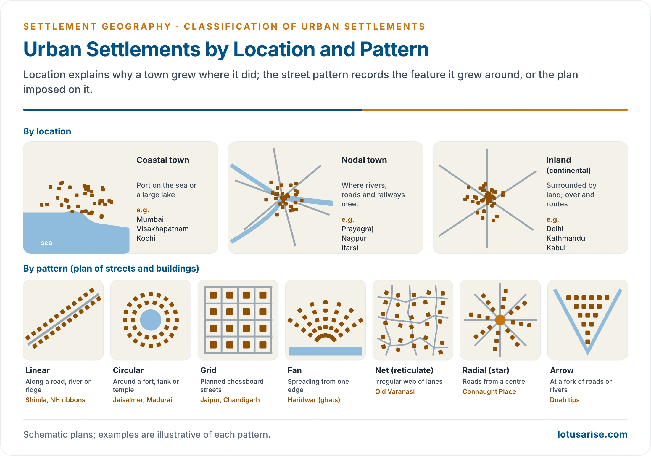
- Location (site and situation) explains why a town grew where it did and what advantages it enjoys.
- Site is the ground the town stands on; situation is its position relative to routes, resources and other places. Classic site types:
- Defensive sites: hilltops, river loops and islands (Gwalior, Chittorgarh, Srirangapatna).
- Wet-point and dry-point sites: near reliable water in dry lands, or on raised ground above floods and marshes.
- Bridging points and fords: where a river can be crossed (London grew at the lowest bridging point of the Thames).
- Gap towns: at a break in a hill range or a pass (Kalka and Kathgodam at the foot of the Himalaya).
- Confluence and route-focus sites: where valleys and routes meet (Prayagraj, Nagpur).
- Situation can change in value: a port loses importance when its harbour silts (Tamralipti, old Surat), and an inland town gains when a railway or expressway arrives.
Coastal Towns
- Towns on the coast of a sea, ocean or large lake. Most began as ports and trading centres on maritime routes.
- Their economy rests on shipping, fishing, international trade and port-based industry (refining, shipbuilding, petrochemicals).
- Examples: Mumbai, Visakhapatnam, Chennai, Kochi, Kanyakumari; London, Singapore, Rotterdam, Shanghai, Sydney.
- Coastal cities now face sea-level rise, storm surges, subsidence and coastal erosion. Jakarta’s sinking and flooding were among the reasons Indonesia chose to build a new capital, Nusantara, in East Kalimantan. Mumbai, Kolkata and Chennai are among India’s most exposed cities.
Nodal Towns
- Towns at convergence points of rivers, roads and railways. They draw their importance from the flow of people and goods through them rather than from their surroundings.
- Types of nodes:
- river confluences (Prayagraj at the Ganga–Yamuna);
- road and rail junctions (Nagpur at the meeting of national highways, Itarsi on trunk railway lines);
- harbour entrances where sea and land routes meet (New York at the mouth of the Hudson);
- mountain passes and gateways to a region.
- Airports are the new nodes. Dubai, Singapore and Amsterdam have built economies on being global aviation hubs, modern equivalents of the railway junction towns.
Inland (Continental) Towns
- Towns surrounded by land, with no direct maritime access. They depend on overland and river routes.
- They grow in fertile plains, strategic valleys and at historic route crossings: Delhi, Kathmandu, Kabul, Moscow, Vienna, Nairobi.
- Many inland cities are river towns, using the river for water, defence and trade: Delhi and Agra on the Yamuna, Kanpur and Patna on the Ganga, Hyderabad on the Musi, Cuttack between the Mahanadi and Kathajodi.
- Air freight, expressways, high-speed rail and dry ports have greatly reduced their old handicap. Chengdu and Addis Ababa have become international hubs through investment in connectivity.
Pattern
- The ground plan of a town records the feature it grew around or the plan imposed on it. Patterns reflect relief, drainage, routes, defence and planning decisions.
- Many of these patterns also occur in villages; the pattern of rural settlements uses the same vocabulary. Pattern is the town’s outline and street plan; models of urban morphology, such as concentric zones and sectors, describe how land uses are arranged within it.
- Factors shaping pattern:
- Relief and drainage: ridges and valleys give linear towns; deltas and mountain feet give fans.
- A central feature: a fort, temple, tank or market gives circular and radial towns.
- Routes: junctions give star and arrow shapes; a single highway gives a ribbon.
- Planning: colonial and modern planners favoured grids, sectors and radial avenues.
The Main Patterns
- Linear: the town grows in a line, straight or curved, along a road, railway, river, canal, coast, valley floor or ridge.
- Common in hilly terrain where flat land is scarce: Shimla, Darjeeling, Mussoorie.
- Around Indian cities, ribbon development along highways runs ahead of planned growth, causing congestion and sprawl. Transit-oriented development seeks to guide such growth around mass transit.
- Circular: houses ring a central feature: a fort, tank, temple, mosque, well, oasis or river loop.
- Jaisalmer grew around its hilltop fort; Madurai’s streets run in concentric rings around the Meenakshi temple.
- Rectangular (grid or chessboard): streets cross at right angles, the product of deliberate planning.
- Advantages: easy navigation, simple plot division and straightforward laying of water, power and sewer lines.
- Examples: Jaipur’s walled city (laid out under Sawai Jai Singh II in 1727), Chandigarh’s sectors (Le Corbusier), Gandhinagar; Manhattan, Melbourne and Barcelona’s Eixample (Ildefons Cerdà).
- Fan: the town spreads outward like a fan from a focus on one side: a riverbank, tank, embankment, forest edge, mountain foot or main gate.
- Common in deltas and at the foot of mountains; Haridwar fans out from the Ganga ghats.
- Net (reticulate): an irregular web of lanes with no geometric order, typical of old organic cores and unplanned growth.
- Examples: the old quarters of Varanasi, the Charminar area of Hyderabad and the mohallas of north Indian cities.
- Planners increasingly prefer upgrading such neighbourhoods in place to demolishing them, since they are often socially cohesive.
- The older accounts also describe it as isolated homes with a central courtyard, irregularly spread in villages and old urban quarters.
- Radial (star): roads radiate from a centre such as a square, palace, fort, market or junction, giving a star shape.
- Examples: Connaught Place and Lutyens’ Delhi (radial avenues and roundabouts), Paris (avenues from the Étoile), Washington D.C. (Pierre L’Enfant’s plan), Moscow’s rings and radials; Laxmi Bai Nagar in Delhi.
- Arrow (triangular): the town fills the triangle between two converging roads or rivers, with its point at the junction.
- Found at doab tips and at Y-shaped road forks across the plains.
Classification by Function, Origin and Age
Function
- Function, the dominant economic activity, is the most meaningful basis of classification. Methods of functional classification of towns range from Harris’s fixed cut-offs and Nelson’s standard deviations to Asok Mitra’s triangular graph for Indian towns.
- Most large cities are multifunctional; a functional label names the dominant activity.
| Functional type | Dominant activity | Indian examples | World examples |
|---|---|---|---|
| Administrative | Government, legislature, courts | New Delhi, Bhopal, Patna, Chandigarh | Washington D.C., London, Canberra |
| Defence | Cantonments, naval and air bases | Visakhapatnam, Pune Cantonment, Ambala | Portsmouth, San Diego |
| Cultural | Pilgrimage and education | Varanasi, Tirupati, Aligarh, Bodh Gaya | Mecca, Jerusalem, Oxford |
| Collection | Mining, fishing, lumbering | Digboi, Zawar, Jharia | Johannesburg (origin), Aberdeen |
| Production | Manufacturing | Jamshedpur, Bhilai, Rourkela, Durgapur | Pittsburgh, Birmingham, Magnitogorsk |
| Transfer and distribution | Trade, wholesale, logistics | Kanpur, Ludhiana, Hapur, Bhiwandi | Alexandria, Kumasi |
| Resort | Tourism, hill and sea resorts | Ooty, Manali, Agra, Goa | Venice, Barcelona, Las Vegas |
| Residential | Housing commuters | Noida, Navi Mumbai, Ghaziabad | Levittown, Milton Keynes |
- Notes on the main types:
- Administrative towns may be historic capitals that grew naturally (London, Cairo, Lucknow) or purpose-built capitals (Washington D.C., Canberra, Brasília, New Delhi, Chandigarh).
- Defence towns guard borders, coasts and passes; modern ones combine bases with research and industry, as Bengaluru does with aerospace and defence laboratories.
- Visakhapatnam holds the Eastern Naval Command, and Pune the Southern Command and DRDO laboratories. Jodhpur is a major air base. Abroad: Halifax in Nova Scotia, Peshawar and Huntsville.
- Cultural towns are religious (Varanasi, Tirupati, Mecca, Vatican City) or educational (Oxford, Cambridge, Aligarh, Pilani, Manipal). Pilgrim towns live by a seasonal economy of lodging, transport and ritual goods.
- Badrinath and Kedarnath are Char Dham sites. Mecca draws over 2 million pilgrims at the Hajj, and Tirupati over 50,000 visitors on an average day, supporting hotels, prasadam, transport and retail.
- Collection towns extract minerals, fish or timber: Digboi grew around India’s first oil refinery (1901), Jharia on its coalfield, Johannesburg on gold.
- Bijolia (Rajasthan) quarries sandstone, and Broken Hill (Australia) grew on mining. Fishing ports add cold storage, canneries and boat-building; lumbering centres add sawmills and paper.
- Production towns cluster near raw materials, energy and transport: steel at Jamshedpur, Bhilai and Rourkela; textiles at Ahmedabad and Surat.
- Main sectors: iron and steel, textiles, automobiles and engineering, chemicals and petrochemicals, electronics. Others: Dhanbad (coal), Bhadravati (iron, steel, paper).
- Transfer and distribution towns move goods between producers and consumers through mandis, warehouses, cold stores and freight yards: Hapur’s grain market, Ludhiana’s hosiery and cycle trade.
- Others: Ahmedabad, Vadodara, Indore, Bhopal and Patna; Kanpur, once the Manchester of the East; Norwich abroad. Kundli and Luhari are newer distribution corridors.
- Resort towns grow around hill stations, beaches, spas, heritage sites and national parks.
- Abroad: Bern, Athens, Florence, Vienna, Ho Chi Minh City, Pattaya and Denpasar. Venice receives about 30 million tourists a year against some 50,000 residents.
- Residential towns house commuters near a parent city; they offer cheaper land and housing but few local jobs.
- After COVID-19 many added local offices and co-working spaces, and the 15-minute city idea entered their planning.
- Recent changes in functional types:
- New capitals are built to relieve overgrown primate cities: Naypyidaw (Myanmar, 2005–06), Egypt’s New Administrative Capital and Indonesia’s Nusantara; in India, Naya Raipur and Amaravati.
- Production towns reinvent themselves after deindustrialisation; Pittsburgh moved from steel to health care, universities and robotics.
- Distribution towns are being reshaped by e-commerce: Bhiwandi near Mumbai has become one of India’s largest warehousing clusters, and multimodal logistics parks are planned under the PM Gati Shakti National Master Plan (2021).
- Collection towns face boom-and-bust; Kolar Gold Fields declined after its mines closed in 2001.
- Resort towns face over-tourism. Venice began charging day-trippers an entry fee in 2024; Shimla, Mussoorie and Manali struggle with water, waste and traffic in the tourist season.
- Residential towns such as Gurugram and Noida have acquired offices and services of their own, moving from dormitory to self-contained towns.
Indian Cities by Cultural History
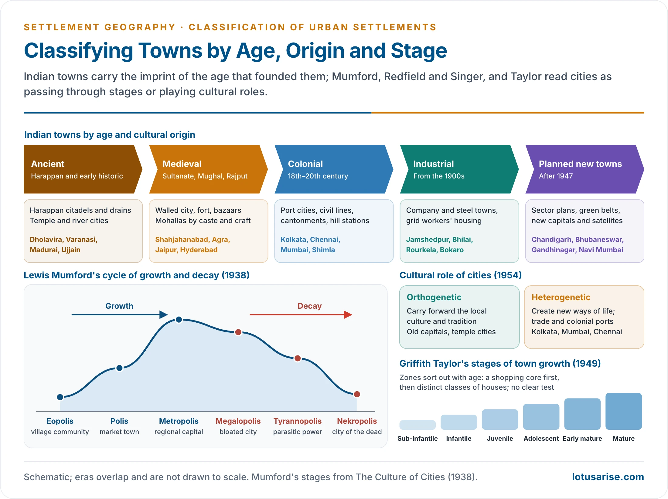
- Indian cities carry the imprint of the period that founded them in their plan, architecture and social pattern. Most large cities today are palimpsests with layers from several periods.
| Type | Characteristics | Examples |
|---|---|---|
| Ancient | Harappan planned citadels and drains; early historic temple, river and capital cities; plan shaped by ritual and caste | Dholavira, Lothal, Pataliputra (Patna), Rajgir, Mathura, Varanasi, Ujjain, Madurai, Kanchipuram, Thanjavur |
| Medieval | Walled cities with forts, gates, palaces, mosques and gardens; dense bazaars; mohallas by community and craft | Shahjahanabad (Delhi), Agra, Jaipur, Hyderabad, Lucknow, Surat, Pune, Nabadwip, Mysuru |
| Colonial | Port and presidency cities; civil lines, cantonments, railway colonies; separate European and Indian quarters; hill stations | Kolkata, Chennai, Mumbai, Shimla, Darjeeling, Dehradun |
| Industrial | Company and steel towns with grid layouts and standard workers’ housing | Jamshedpur, Asansol, Kulti, Bhadravati; after 1947 Bhilai, Rourkela, Durgapur, Bokaro |
| Planned after 1947 | Sector plans, green belts, separate residential and market areas; new capitals and satellite towns | Chandigarh (Le Corbusier), Bhubaneswar, Gandhinagar, Navi Mumbai, Naya Raipur |
- Each period left a distinct layer in the morphology of Indian cities: the temple or fort core, the bazaar, the civil lines and cantonment, the railway colony and the planned sector. Their beginnings lie in the wider origin and growth of settlements.
Planned and Organic Towns
- By mode of origin, towns are either organic (grown piecemeal over centuries around a market, shrine, fort or crossing) or planned (laid out at one time to a design).
- India’s planned towns since 1947 fall into groups:
- New capitals: Chandigarh, Bhubaneswar, Gandhinagar, Naya Raipur, Amaravati.
- Industrial townships: Bhilai, Rourkela, Durgapur, Bokaro, built with the public-sector steel plants.
- Satellite towns and counter-magnets to decongest metropolises: Navi Mumbai, Noida, and the NCR’s satellite towns.
- Greenfield smart and industrial cities on new corridors: GIFT City and Dholera in Gujarat.
- Organic cores are dense, mixed and walkable but congested; planned towns are orderly but often car-dependent, segregated by income and slow to fill.
Stages of Growth and Decay
Griffith Taylor’s Stages (1949)
- Thomas Griffith Taylor, extending William Morris Davis’s idea of sequential landscape change, described towns passing through stages as their zones sort out:
- Sub-infantile: a single ill-defined street; no clear zones.
- Infantile: no separation of shops, workshops and houses; no factories.
- Juvenile: a commercial quarter begins to separate near the centre.
- Adolescent: residential zones start to differentiate.
- Early mature: residential differentiation becomes marked.
- Mature: a separate commercial core and four distinct classes of housing, from mansions to shacks.
- Evaluation: interesting academically, but no measurable test decides which stage a town is in, and the sequence fits Western cities under a market economy, as Taylor himself accepted.
Lewis Mumford’s Cycle (1938)
- Lewis Mumford, in The Culture of Cities (1938), saw cities rising through three stages of growth to a peak and then passing through three stages of decay:
| Stage | Type | Character |
|---|---|---|
| Growth 1 | Eopolis | Rising village community, mainly agricultural |
| Growth 2 | Polis | Market town; civic institutions with local loyalties |
| Growth 3 | Metropolis | Large city with a cosmopolitan population, specialised work and wide influence |
| Decay 1 | Megalopolis | Bloated city in which wealth and size dominate life |
| Decay 2 | Tyrannopolis | Parasitic, exploitative city; moral apathy; boom and slump |
| Decay 3 | Nekropolis | “City of the dead”: overcrowding, disorder, war and ruin |
- Mumford saw imperial Rome as the archetype of a megalopolis sliding towards tyrannopolis, and warned that the giant industrial cities of his own day were on the same path.
- Older lists give these examples: polis, medieval English market towns; metropolis, Plato’s Athens, Shakespeare’s London, Tagore’s Calcutta and Emerson’s Boston; megalopolis, 2nd-century Rome, 18th-century Paris, 20th-century New York and late 20th-century Calcutta; nekropolis, Babylon, Nineveh and Rome.
- Mumford also followed Patrick Geddes in describing techno-economic phases of city life:
- Eotechnic: wind, water and wood; medieval towns.
- Paleotechnic: coal and steam; the smoky, crowded industrial city (Victorian Manchester, early industrial Kolkata).
- Neotechnic: electricity, new materials and fast communications; cleaner, more spread-out cities.
- Biotechnic: a hoped-for phase of harmony between people and nature, which Mumford in 1938 saw only on the horizon.
- Evaluation: a moral and cultural reading rather than a measurable scheme, but its warnings about giantism, congestion and the loss of civic life anticipate today’s concerns about megacities.
Cultural Role of Cities: Redfield and Singer (1954)
- Robert Redfield and Milton Singer classed cities by their cultural role:
- Orthogenetic cities carry forward and refine an indigenous culture: old administrative-cultural capitals and temple cities (Varanasi, Madurai, Kyoto).
- Heterogenetic cities create new ways of life through trade, administration and contact with outsiders: commercial and colonial port cities (Kolkata, Mumbai, Chennai).
- They split each group further:
- Pre-industrial: administrative-cultural cities of an indigenous bureaucracy and learning, and cities of native commerce run by merchants.
- Examples: Peiping, Lhasa, Kyoto and Allahabad; Marseilles and early Canton.
- Modern: metropolises of a worldwide managerial and business class, and cities of modern administration such as Washington D.C. and New Delhi.
- Pre-industrial: administrative-cultural cities of an indigenous bureaucracy and learning, and cities of native commerce run by merchants.
- Many Indian cities are both: an orthogenetic old city beside a heterogenetic colonial or modern one, as in Delhi.
Global City Classification and Evaluation
World Cities and Global Cities
- As the economy globalised, geographers began to classify the largest cities by their role in the world economy rather than by size.
- Peter Hall, The World Cities (1966), described the cities where world-scale political and economic power concentrates.
- John Friedmann, “The World City Hypothesis” (1986), ranked cities as command points of global capital, in core and semi-periphery.
- Saskia Sassen, The Global City (1991), showed how New York, London and Tokyo concentrate the advanced producer services (finance, law, accounting, consulting, advertising) that run a dispersed global economy.
- A global city is defined by connections and control functions, not by population. Lagos and Dhaka are megacities but not leading global cities, while Zurich and Luxembourg are small but highly connected.
- Why a few megacities organise the world economy and culture:
- They concentrate headquarters of multinational firms, stock exchanges and banks, and the specialised lawyers, accountants and consultants these need.
- They are the hubs of air travel, data and shipping, so information and decisions flow through them.
- They dominate media, fashion, film and higher education (New York, London, Paris, Tokyo; in India, Mumbai’s finance and film industry).
- Agglomeration economies keep them ahead: talent, capital and ideas attract more of the same.
- Their dominance also widens the gap between global cities and their own hinterlands, and within the city between global professionals and low-paid service workers.
The GaWC Classification
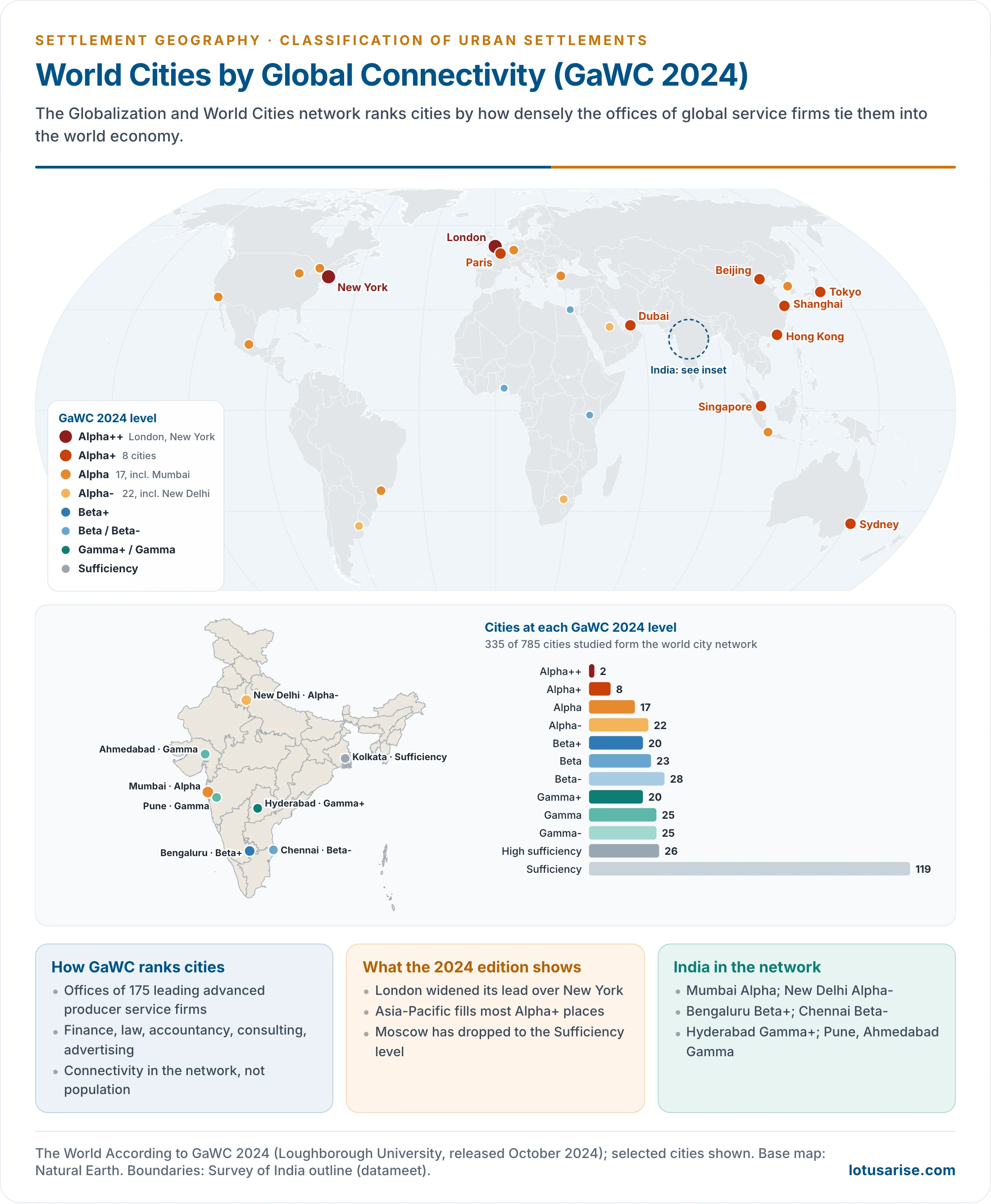
- The Globalization and World Cities (GaWC) research network, based at Loughborough University, has published “The World According to GaWC” since 1999.
- Method:
- It maps the office networks of 175 leading advanced producer service firms across 785 cities.
- From these it computes each city’s network connectivity: how strongly it is tied into the world city network.
- Cities are then grouped into levels: Alpha (++, +, plain, −), Beta (+, plain, −), Gamma (+, plain, −), and High sufficiency and Sufficiency.
- Meaning of the levels:
- Alpha++: London and New York, far more integrated than any other city; together the core of the network.
- Alpha+: cities that complement them, largely serving Pacific Asia.
- Alpha and Alpha−: very important world cities linking major regions and states into the world economy.
- Beta: important world cities linking their region or state into the world economy.
- Gamma: world cities linking smaller regions, or major cities whose global strength lies outside producer services.
- Sufficiency: not world cities, but with enough services not to depend on them; often smaller capitals and old manufacturing centres.
| Level | Cities (2024) | Examples |
|---|---|---|
| Alpha++ | 2 | London, New York |
| Alpha+ | 8 | Hong Kong, Beijing, Singapore, Shanghai, Paris, Dubai, Tokyo, Sydney |
| Alpha | 17 | Seoul, Milan, Toronto, Frankfurt, Chicago, Jakarta, São Paulo, Mumbai |
| Alpha− | 22 | Shenzhen, Zurich, Riyadh, Johannesburg, Washington, New Delhi |
| Beta (+, plain, −) | 71 | Bengaluru, Cairo, Nairobi, Lagos, Chennai |
| Gamma (+, plain, −) | 70 | Hyderabad, Dhaka, Pune, Ahmedabad |
| High sufficiency and sufficiency | 145 | Kolkata, Ottawa, Moscow |
- The 2024 edition (released October 2024) classed 335 of 785 cities as part of the world city network.
- London keeps first place and has widened its lead over New York.
- Asia-Pacific cities fill most Alpha+ places; Sydney joined Alpha+.
- Moscow has dropped to the Sufficiency level.
- India in GaWC 2024:
- Mumbai: Alpha, India’s financial and corporate capital.
- New Delhi: Alpha−, the political capital with a large NCR service economy.
- Bengaluru: Beta+; Chennai: Beta−; Hyderabad: Gamma+; Pune and Ahmedabad: Gamma.
- Kolkata ranks only at Sufficiency, a sign that a megacity need not be a global city.
- Uses of the ranking: it guides firm location and investment, helps governments benchmark cities seeking global status, and lets researchers track the rise of Asian and Gulf cities over 25 years of editions.
- Criticism of global-city rankings:
- They measure corporate services only, not manufacturing, culture, politics or quality of life.
- They depend on which firms are chosen and favour cities with Western-style business services.
- They say little about the inequality that global-city growth produces inside the city.
Evaluation of the Bases
- Each basis has a purpose:
- Size is simple and comparable, but thresholds are arbitrary and differ between countries.
- Location and pattern explain site and form but say little about the economy.
- Function reveals the economic base but rests on coarse census categories.
- Origin and age capture history and culture but are descriptive.
- Global connectivity captures the new hierarchy of the world economy but covers only the largest cities.
- A full picture of any city combines them:
- Mumbai is a megacity, a coastal port on an island site, a diversified city with a colonial core and planned satellite (Navi Mumbai), and an Alpha world city.
- Varanasi is a million-plus city on a river terrace, with a net-patterned old core, a religious and cultural function and an ancient, orthogenetic character, but no place in the global city network.
- Jamshedpur is a Class I inland industrial town with a planned grid township, founded in the industrial age around one steel plant.
Previous Year Questions
1989Write short note: Classification of cities.1990Write short note: Function, classification and hierarchy of urban settlements.2003Discuss the census definition of urban areas in India.2021Small number of mega-cities are playing a key role in organization of global economics and culture. Explain.




