

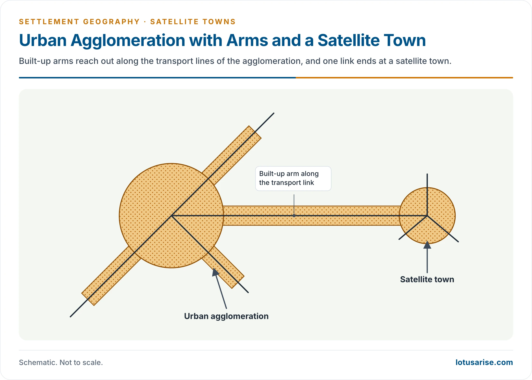
- A satellite town is an urban centre functionally tied to a large mother city. It usually lies on a major transport line to that city and serves as its secondary settlement.
- It begins as a tool of decentralisation: housing, industry or institutions are moved out of a congested metropolis into smaller towns around it.
- In practice satellites grow into mature towns with their own municipalities, functions and central business districts, and many are finally absorbed into the metropolis’s urban agglomeration.
Origin and Evolution

Background
- Urbanisation followed industrialisation. The Industrial Revolution in Europe and North America drew huge numbers of rural migrants into factory cities.
- The result was overcrowding, slums, disease and smoke: the “urban miseries” of the nineteenth-century city.
- Big industrial cities and metropolises needed decongestion.
- Without planning, suburban growth spread haphazardly along the main transport lines as homes and businesses moved out.
The Garden City
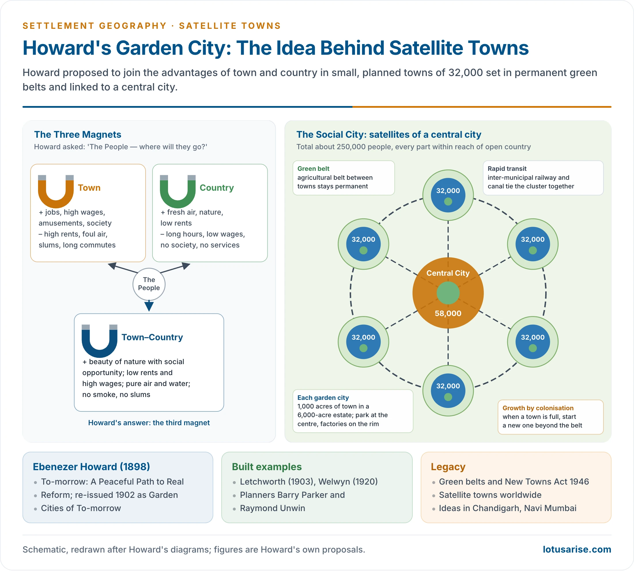
- Ebenezer Howard proposed the Garden City in To-morrow: A Peaceful Path to Real Reform (1898). It was re-issued in 1902 as Garden Cities of To-morrow.
- His “three magnets” diagram set the town (jobs, wages and society, but high rents, foul air and slums) against the country (fresh air and low rents, but long hours, low wages and no society).
- He proposed a third magnet, town–country, that would combine the advantages of both.
- The plan:
- Towns of about 32,000 people on 1,000 acres at the centre of a 6,000-acre estate, with a central park, civic buildings and factories on the rim.
- Set away from the city limit, each town mixed residential colonies with institutional, educational, service and entertainment areas.
- Each town was ringed by a permanent agricultural belt.
- When a town was full, a new one would be founded beyond the belt.
- Six garden cities would cluster around a central city of 58,000, linked by an inter-municipal railway. Howard called this cluster of about 250,000 people the “Social City“.
- It was a philanthropic, even utopian idea, with roots in co-operative and socialist thought. The aim was to lift the quality of life of wage earners by settling workers away from polluted cities.
- Land was to be held in common ownership, so that rising values funded the town.
- Two garden cities were built: Letchworth (1903), planned by Barry Parker and Raymond Unwin, and Welwyn Garden City (1920).
From Garden City to Satellite Town
- The term satellite city was popularised by Graham Romeyn Taylor (1915) in Satellite Cities: A Study of Industrial Suburbs.
- After the First World War the garden-city idea was adapted. Industrial demand led to factories being built in the new towns too, and they came to be called satellite towns.
- Many served mainly as homes for city workers, and were also called dormitory towns.
- Patrick Abercrombie’s Greater London Plan (1944) proposed a green belt and eight new towns beyond it.
- The New Towns Act, 1946 followed. Stevenage was the first new town, and Harlow, Crawley and Basildon followed.
- Other planned satellites:
- Stockholm: Vällingby (1954), an “ABC” town of work, housing and centre, on the metro line.
- Paris: five villes nouvelles of the 1965 regional plan, such as Cergy-Pontoise and Marne-la-Vallée.
- Tokyo: Tama New Town.
- Seoul: Bundang and Ilsan.
Definition and Features
- A satellite town is an urban centre functionally integrated with a mega city. It lies on a major transport line to that city and serves as a secondary settlement to it.
- Its main features:
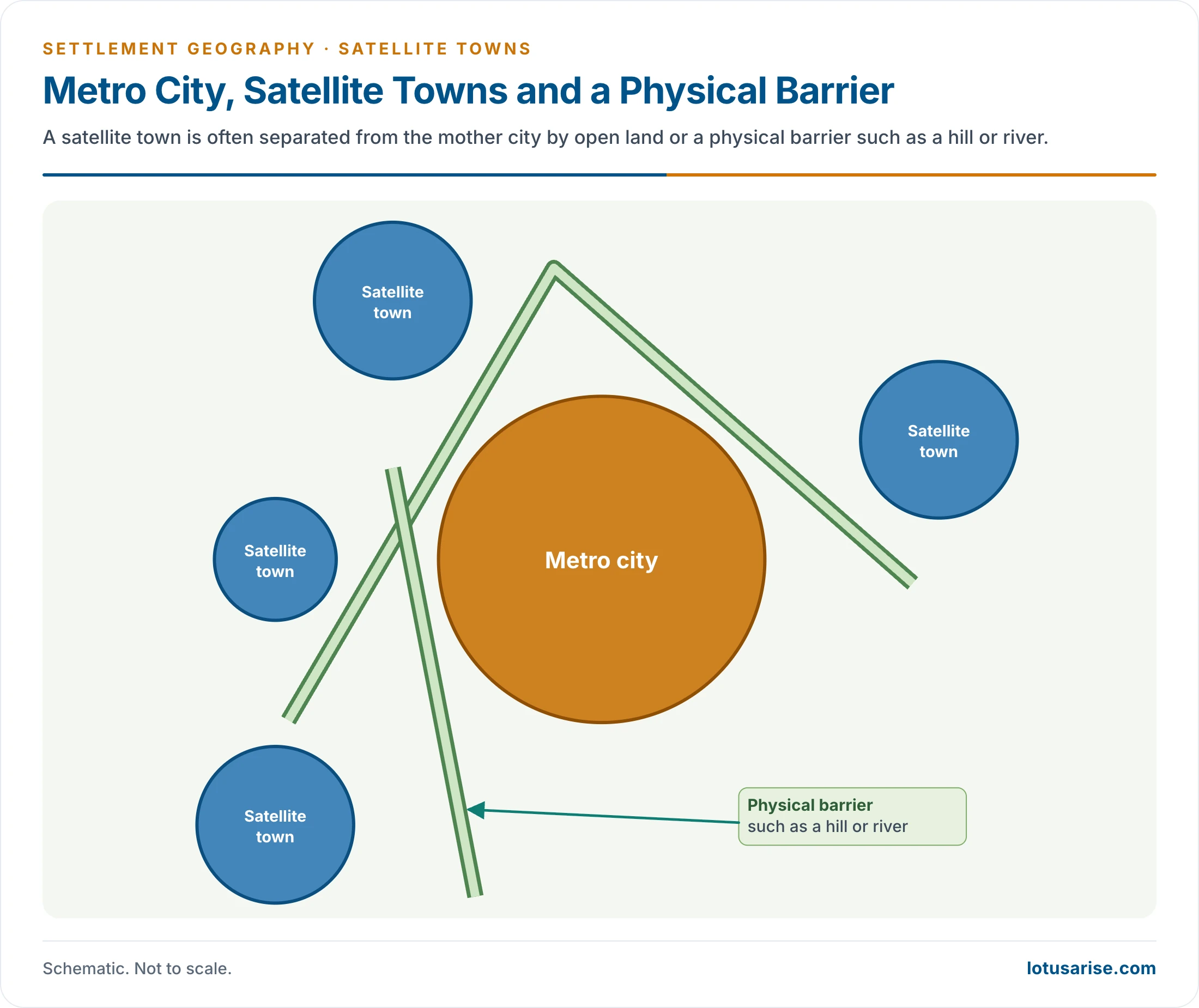
- It may be new or old. It is often separated from the mother city by open land or a physical barrier such as a hill or river.
- It is wholly or partly self-governing, but functionally dependent on the mother city.
- It is part of the city’s daily urban system through commuting.
- It grows its own CBD, specialises in some function, and becomes a destination for in-migration in its own right.
- Over time satellite towns grow into twin cities, then become part of the urban agglomeration, and the cycle starts again with the next ring of satellites.
Satellite Town and Related Forms
| Form | Relation to the city | Self-containment | Example |
|---|---|---|---|
| Suburb | Contiguous extension of the built-up area | Low: housing, some shops | Dwarka (Delhi), Andheri (Mumbai) |
| Satellite town | Separate town on a transport line, tied by daily commuting | Partial: own municipality, CBD, some jobs | Faridabad, Thane |
| New town | Planned from scratch, often on a new site | High by design | Stevenage, Navi Mumbai, Chandigarh |
| Counter-magnet | Distant city developed to divert migration from the metropolis | High: a regional centre in its own right | Hisar, Bareilly, Kota for Delhi |
- The lines blur in practice. A planned new town near a metropolis works as a satellite, and an old satellite swallowed by sprawl becomes a suburb.
- The satellite is one part of the city’s rural–urban fringe, where urban and rural land uses interpenetrate.
Purposes and Factors of Growth
Purposes
- Decongestion: housing for the city’s wage earners outside the core.
- Relocation of industry: labour-intensive and polluting manufacturing is moved out of the city.
- Cheaper land for institutional areas such as universities, hospitals and government offices.
- Self-government: a satellite has its own administration and municipal area.
- Local services: its own commercial centre, bus and railway stations, schools and hospitals.
- Regional balance: satellites spread growth across the city-region, which is a core aim of metropolitan planning.
Factors of Growth
- Six factors have driven the emergence of satellite towns since the Second World War:
- Rapid growth of the mother city.
- This is acute in developing countries. Delhi UA grew from 12.9 million to 16.3 million between 2001 and 2011 (Census).
- An older reckoning put Delhi’s growth at about 4 lakh people a year, with Mumbai at a similar rate. The World Disasters Report likened the growth of both cities to a disaster, and ecologists called the growth of these former colonial cities unprecedented and unsustainable.
- Planners develop satellites to absorb this growth. Ghaziabad and Faridabad were promoted as industrial satellites, but Delhi’s own population pressure did more to make them grow.
- Ghaziabad UA nearly doubled, from 1.22 million to 2.38 million, in the same decade.
- Kawasaki grew in the same way as an industrial town of Tokyo.
- Functional specialisation.
- Old towns have mixed functions. Newer satellites are often built for one function, such as the dormitory towns of Europe.
- Development of transport.
- A new railway junction or highway node at some distance from a city becomes the seed of a satellite town that serves the city’s traffic.
- Jasidih grew as the railway town for Deoghar, and Khurda Road for Puri.
- Environmental factors.
- These matter most in developed countries. Polluted, congested old cores push housing and polluting industry outwards.
- Sparrows Point grew as the steel-making outlier of Baltimore. New London is also cited for Boston, although it lies in Connecticut, far beyond Boston’s commuter belt.
- Regional planning.
- Before the Second World War, planning meant a master plan for one town in isolation.
- Planning now works at the regional scale, which deliberately develops satellites. The National Capital Region plan is India’s leading example. An older count credits it with seven satellite towns, meant to stop further pressure on Delhi.
- Urbanisation of nearby villages.
- This is common in developing countries through the diffusion of urban traits.
- Villages near a city come to depend on it for jobs and markets. City people settle there, and the village’s morphology changes until a town structure emerges.
- Bahadurgarh and Ballabhgarh near Delhi, and Sarnath near Varanasi, grew this way.
- Rapid growth of the mother city.
Types of Satellite Towns
| Type | Character | Examples |
|---|---|---|
| Dormitory | Empty by day while the mainly male workforce commutes; revives when commuters return; roads busy mornings and evenings | Loni (Delhi), New Ghaziabad, Patliputra Colony (Patna), Vasai–Virar (Mumbai) |
| Industrial | Industry is the reason for the town and its basic function | Faridabad, Ghaziabad, Maraimalai Nagar (Chennai), Kawasaki (Tokyo) |
| Administrative | New seats of government beside an older city | Gandhinagar (Ahmedabad), Dispur (Guwahati) |
| Transport | Grows round a railway junction or port serving the city | Waltair (Visakhapatnam), Jasidih (Deoghar), Khurda Road |
| Educational | Grows round universities and institutes | Cambridge (cited for London), Santiniketan (Bolpur), BHU campus (Varanasi) |
| Mixed | Former village grown into a town of mixed functions | South Hill (London), Phulwari Sharif (Patna), Bahadurgarh (Delhi) |
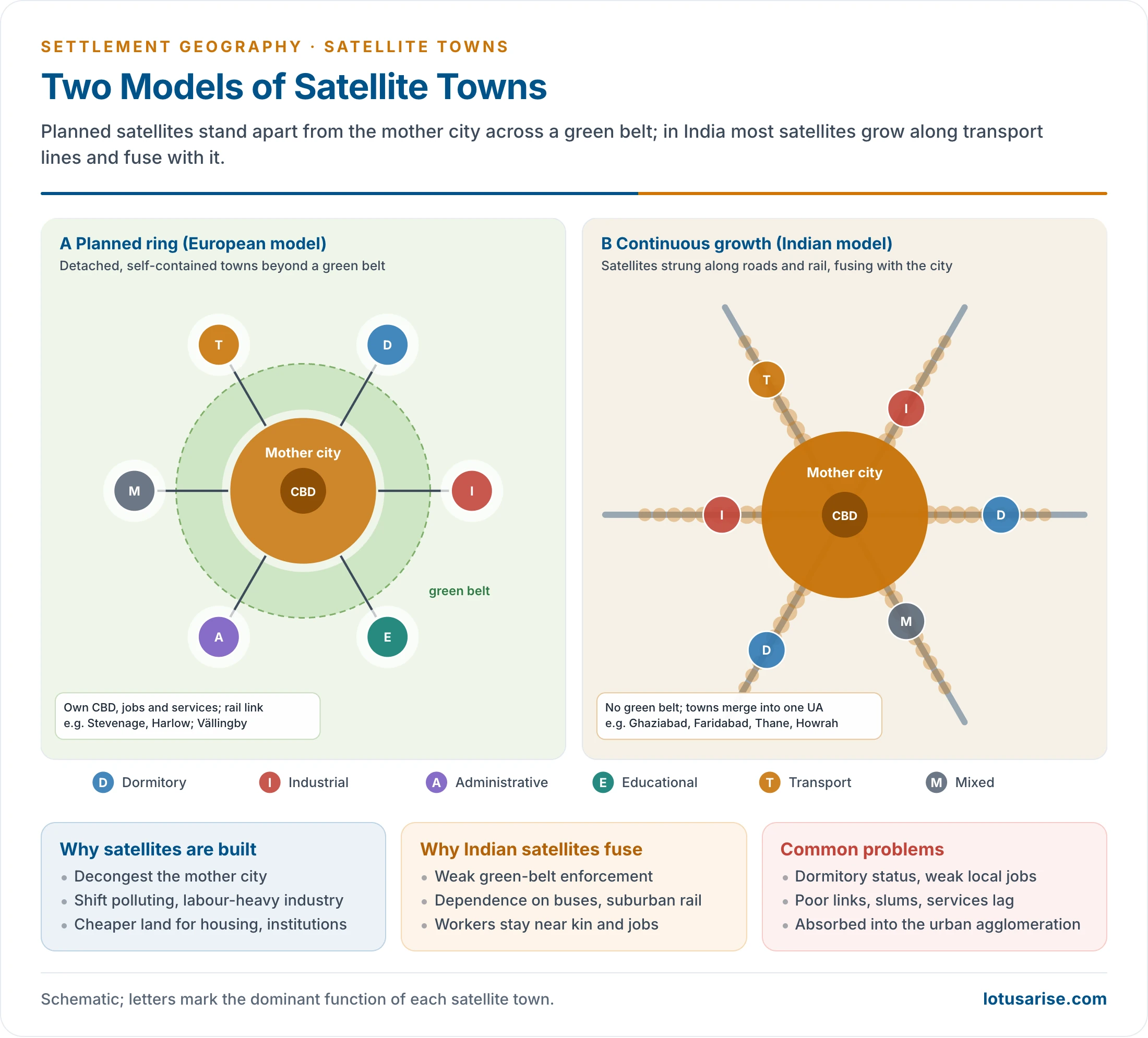
- Two models of growth can be distinguished.
- The planned ring (European model):
- Satellites stand apart from the mother city across a green belt.
- Each is planned to be largely self-contained, with its own jobs, services and rail link.
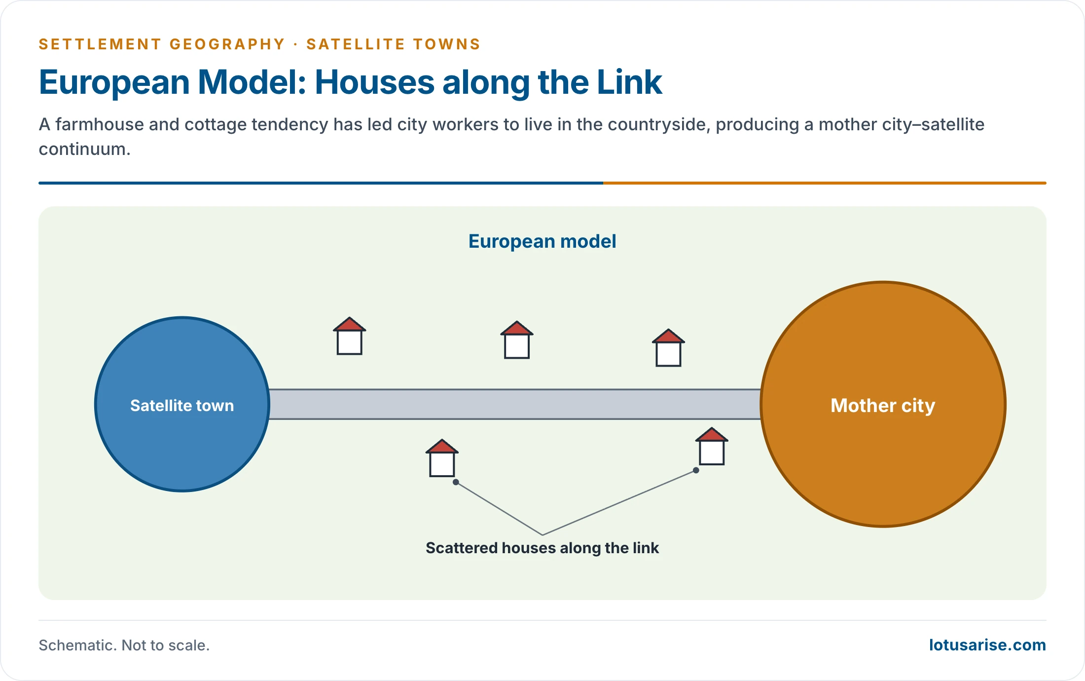
- Since the 1970s a farmhouse and cottage tendency and environmental consciousness have led many city workers to live in the countryside. This has produced a mother city–satellite continuum even in Europe.
- The continuous model (India):
- Satellites grow continuously along transport lines and fuse with the mother city.
- Social factors: families settle close to urban relatives and friends.
- Transport: most workers depend on buses and suburban trains, not private vehicles, so they live near the city and its routes.
- Weak control of land use around cities allows the gaps to fill.
- In both cases, the diffusion of urban elements into the countryside is at work.
Satellite Towns in India
Around the Metropolises
- Delhi:
- The first Master Plan (1962) proposed ring towns such as Ghaziabad, Faridabad, Gurgaon (now Gurugram), Bahadurgarh and Narela to take part of the capital’s growth.
- Faridabad began in 1949 as a township for refugees from Partition. Noida (1976) and Greater Noida followed in Uttar Pradesh.
- Meerut, Sonipat and Panipat are farther-out NCR towns.
- Mumbai:
- Navi Mumbai has been planned since 1970 by CIDCO across the harbour, to draw people and offices from the island city. Its municipal corporation counted 11.2 lakh people in 2011.
- Thane and Kalyan–Dombivli grew along the suburban railway. Vasai–Virar more than doubled, from 0.52 million to 1.22 million, between 2001 and 2011.
- Pune is often listed as a satellite of Mumbai. It is better seen as a separate metropolis tied to Mumbai by the expressway and rail corridor.
- Kolkata: the planned townships of Kalyani, Salt Lake (Bidhannagar) and New Town (Rajarhat).
- Chennai: Maraimalai Nagar, an industrial satellite on the southern highway.
- Hyderabad:
- Secunderabad, a former cantonment, has fused with the city as a twin city.
- Cyberabad grew as an IT satellite.
- A Future City Development Authority was created in March 2025 for a new city of about 765 km² to the south.
- Bengaluru: satellite growth centres such as Hoskote, Nelamangala, Anekal, Bidadi and Ramanagara in the metropolitan region, tied by a Satellite Town Ring Road.
- Ahmedabad: Gandhinagar, the State capital since 1970, is its administrative satellite.
- Chandigarh: Panchkula and Mohali began as mainly residential towns beside the city.
- United States: an older estimate put nearly 50% of the urban population in satellite cities. Allentown is the example given for New York.
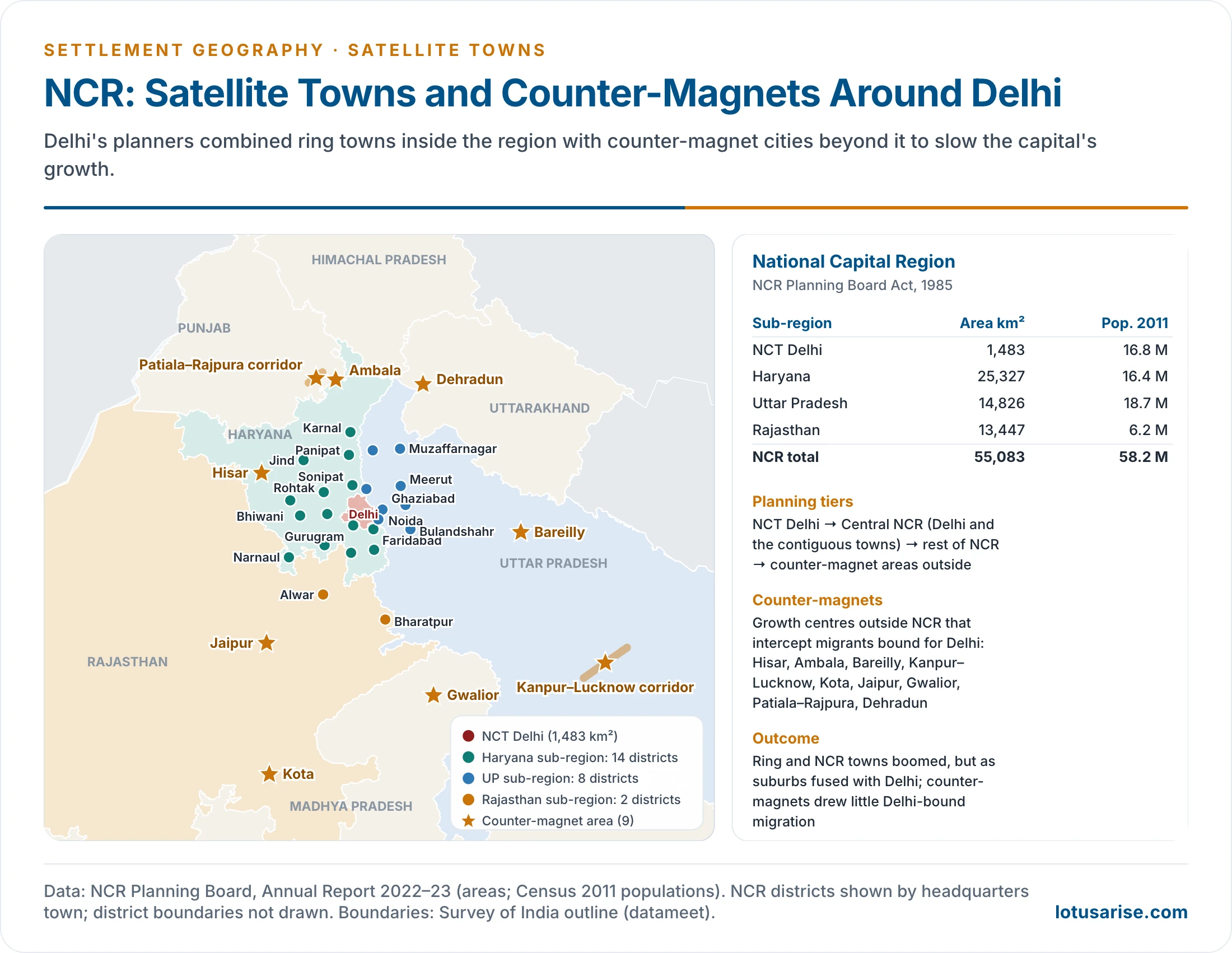
NCR: Ring Towns and Counter-Magnets
- The National Capital Region Planning Board Act, 1985 set up India’s first statutory inter-State regional plan to decongest Delhi.
- The region now covers 55,083 km² with 58.2 million people (Census 2011).
- It comprises NCT Delhi, 14 districts of Haryana, 8 of Uttar Pradesh and 2 of Rajasthan.
- Two strategies work together:
- Inside the region:
- Ring towns and NCR towns (Gurugram, Noida, Ghaziabad, Faridabad, Sonipat, Meerut) receive housing, industry and offices.
- They are linked to Delhi by expressways, the metro and the Delhi–Meerut RRTS.
- Outside the region: counter-magnet areas are growth centres that intercept migrants who would otherwise head for Delhi.
- There are nine: Hisar, Ambala, Bareilly, the Kanpur–Lucknow corridor, Kota, Jaipur, Gwalior, the Patiala–Rajpura corridor and Dehradun.
- The idea applies the growth pole and growth centre approach to regional balance.
- Inside the region:
- Results:
- The NCR towns boomed, but as suburbs that fused with Delhi, not as self-contained satellites.
- Commuting into Delhi rose. Counter-magnets drew little Delhi-bound migration because they lacked investment and jobs on a matching scale.
- Unplanned growth around Delhi brought peri-urban sprawl and some of the world’s worst air pollution.
Problems of Satellite Towns
- The general problems of urban areas: crime, vandalism, and slums and squatter settlements.
- Weak economic base: too few local jobs, so the town stays a dormitory and daily commuting grows.
- Infrastructure lag: roads, water, sewerage, schools and hospitals trail behind the housing.
- Poor connectivity to the mother city in many cases, or connectivity that only pulls people back into the core.
- Governance gaps: development authorities build the town but hand it to weak municipalities, or none.
- Loss of the green belt: satellites merge with the city and with one another, recreating the congestion they were meant to relieve.
Planning Principles for Successful Satellites
- Jobs–housing balance: enough local employment that the town is not a dormitory; offices, industry and services move with the people.
- Rapid transit from the start: a rail or metro link to the core and to other satellites, with transit-oriented development around stations. Stockholm’s metro-linked suburbs show how this keeps commuting manageable.
- A protected green belt or green wedges, so that satellites do not merge with the city.
- Early infrastructure: water, sewerage, roads, schools and hospitals before or with the housing.
- Affordable housing and social mix, so that the town is not only for the rich or only for displaced slum dwellers.
- Land policy: land pooling and land value capture to fund trunk infrastructure, as CIDCO did by selling serviced plots in Navi Mumbai.
- Its own elected government with real powers once the development phase ends.
Evaluation
- The philanthropic and utopian ideal of the garden city faded after the First World War. Most satellites today face the same urban problems as their mother cities.
- Urbanisation is dynamic. Satellites become twin cities, then parts of the urban agglomeration, and the need for another ring of satellites follows.
- Gurugram, Noida and Navi Mumbai are now metropolitan centres in their own right.
- Satellite growth therefore has to be planned within a regional framework. That framework needs a protected green belt, local jobs and transit-oriented development on rail corridors, so that the old garden-city aims of balance and open space are kept.
- India’s town planning has tried to do this through master plans and new towns, with mixed results.
Previous Year Questions
2005Discuss the experience of regional planning in India in the context of the National Capital Region.





the article which u have given is a nice one-stop solution for hidden topics of syllabus’
Excellent content.. I have never been fascinated by any online content pertaining to geography…
Worth it 😊…..best content 😄😃