

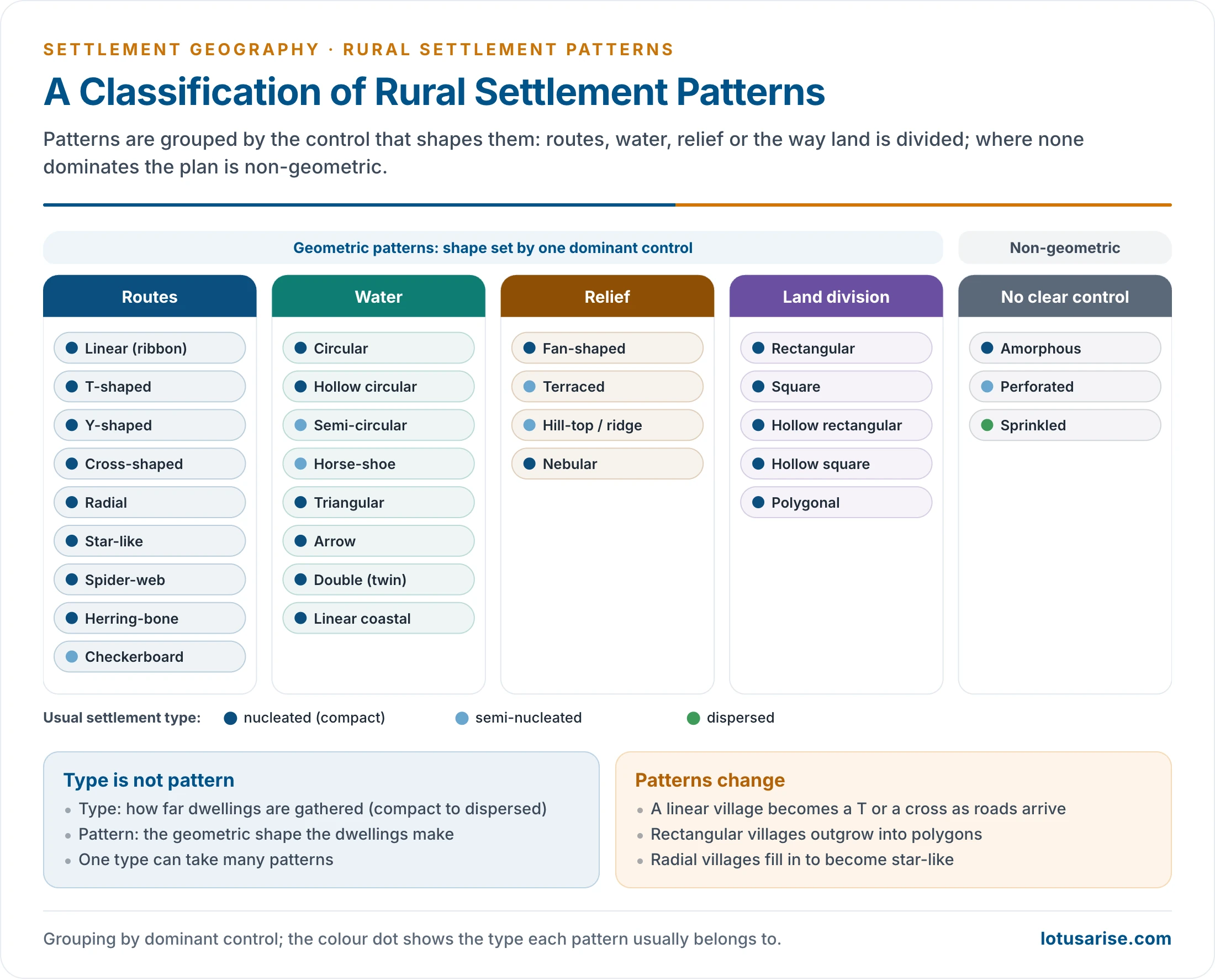
- Pattern is the geometrical configuration, or external morphology, of a rural settlement: the shape made by the arrangement of its houses, lanes and roads.
- Emrys Jones defined it as the relationship between one house or building and another.
- It reflects the layout plan of the village, the shape of its fields and the pattern of its transport lines, and it records the site and history of the settlement.
- Pattern differs from type. Type is the degree of nucleation or dispersion; pattern is the shape. Each type can take several patterns, and a compact village may be rectangular, circular or star-like.
Meaning and Controls

Geometric and Non-geometric Patterns
- Patterns are read from large-scale maps, topographical sheets and aerial or satellite images.
- A geometric pattern has a recognisable shape (linear, rectangular, circular, radial) because one control dominates: a road, a river, a tank, a slope or the division of land.
- A non-geometric pattern (amorphous, perforated, sprinkled) has no clear shape because several controls act together or none dominates.
- Patterns are linked to types:
- Nucleated villages take most geometric shapes: rectangular, square, circular, radial, star, triangular, arrow, herring-bone and polygonal, among others.
- Semi-nucleated settlements are often horse-shoe, hill-top, perforated or checkerboard.
- Dispersed settlements are sprinkled, with no pattern.
Controls of Pattern
- Site and relief:
- Level plains allow regular grids and rectangles.
- Slopes give terraced and linear forms, crests give hill-top and ridge villages, and the foot of a hill gives fan and horse-shoe shapes.
- Water: a tank or pond gives circular and hollow forms; a river bank, canal or coast gives linear forms; meanders and ox-bows give semi-circular and horse-shoe forms; confluences give triangular forms.
- Transport routes: houses face roads and paths, so routes give linear, T, Y, cross, radial, star, spider-web, herring-bone and checkerboard shapes.
- Land division and field shape: the rectangular fields of the northern plain, laid out in bighas and kept rectangular for ploughing and cart tracks, give rectangular and square villages.
- Society: caste quarters, the house of the landlord or headman at the centre, and a shared temple or chaupal organise the plan from within.
- Defence and history: hill-top and circular walled villages were built for safety; planned colonisation imposed grids.
- These controls change over time, so patterns evolve: a linear village becomes a T or a cross when a new road arrives, and a rectangular village outgrows its frame into a polygon.
Pattern Families
Patterns Shaped by Routes
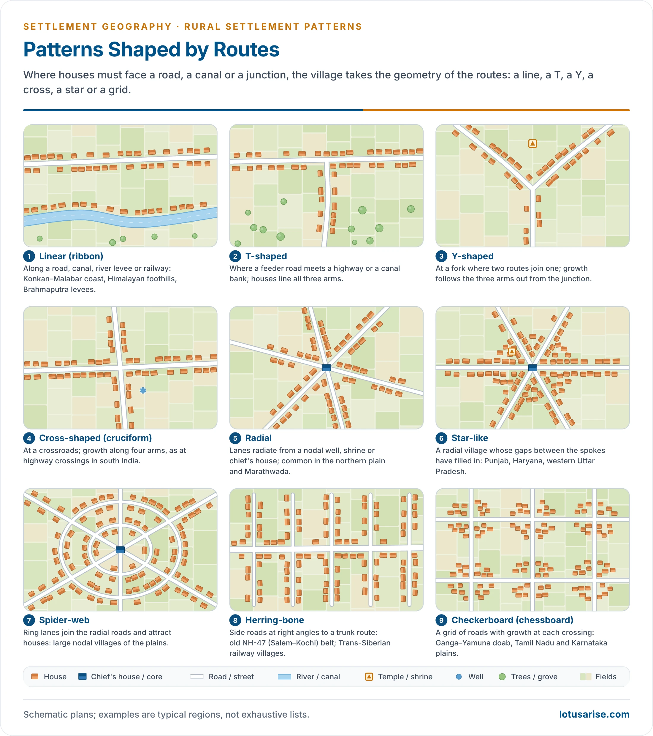
- Linear (ribbon or string) pattern:
- Houses stand in one or two rows along a road, railway, canal, river bank, levee or coast. The main street runs parallel to the line, and most shops face it.
- Fishing villages stand along the coast above high-tide level.
- India:
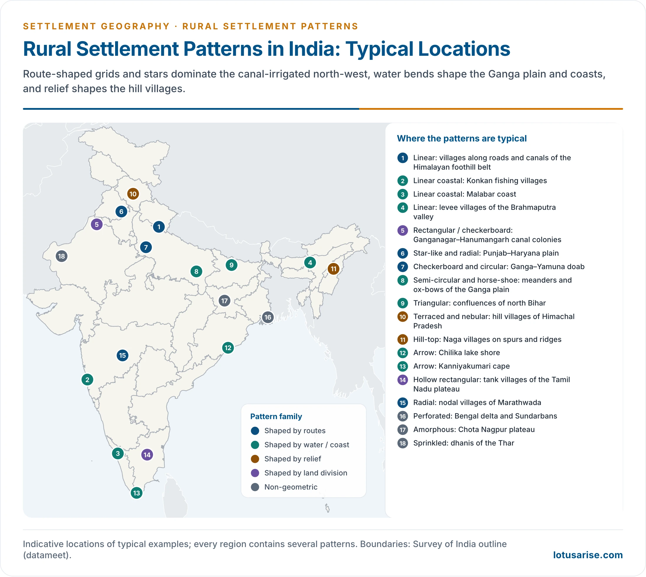
- The middle and lower Ganga plain and the Himalayan foothill belt from Jammu and Kashmir to Sikkim.
- The Malabar and Konkan coasts, including the coastal Mappila (Moplah) villages of north Malabar.
- The levees of the Brahmaputra in Assam.
- The banks of dead rivers in Murshidabad, Nadia and the 24 Parganas of West Bengal.
- River and canal banks in Tripura and Odisha (Balasore), in Tamil Nadu (Thanjavur, Ramanathapuram, Tirunelveli) and in parts of Maharashtra, and the long lines of villages on deltas and estuaries.
- The coastline of over 6,000 km, dotted with fishing villages, and fishing villages along roads in the Ganga–Yamuna doab.
- Villages strung along highways such as old NH-7.
- World: villages along the Trans-Siberian Railway and the Canadian Pacific line, and along the Nile and Indus. The German Strassendorf (street village) is a classic linear form.
- T-shaped pattern: develops where a feeder road meets a highway, or a path meets a canal bank, at a T-junction; houses line all three arms.
- Y-shaped pattern: develops at a fork where two roads or paths join one; growth follows the three arms out from the junction.
- Cross-shaped (cruciform) pattern:
- Develops where two roads cross; houses spread along all four arms, and growth is fastest near the crossing.
- It is common in villages with well-developed roads, as across Europe, and at highway crossings in south India, such as district roads meeting old NH-7 south of Bengaluru.
- Radial pattern:
- Roads, streets and paths converge on a nodal point from several directions; houses are built along them.
- The nodal centre holds the landlord’s or headman’s house, a well, a temple or a mosque.
- About one-third of Indian villages are radial, most of them in the northern plain. It also occurs in Marathwada, on the ridges of the Deccan, near Haridwar, and on dome-like uplands such as the Ozark plateau of the USA.
- Star-like pattern:
- A refined radial pattern: the spaces between the radiating roads fill with houses.
- Building starts at the node and spreads outward, fastest along the roads, so the village takes the shape of a star.
- It is typical of the fertile, densely roaded plains of Punjab, Haryana and western Uttar Pradesh. A star also forms where three or more routes cross, as on NH-47 in Tamil Nadu, in coastal Odisha and in the mining state of Alabama, USA.
- Spider-web pattern:
- Develops when ring lanes link the radial roads and themselves attract houses.
- The result looks like a web; it is found in large nodal villages of the plains.
- Herring-bone pattern:
- Develops where one trunk road or railway is crossed at right angles by many side roads (state highways, district roads), with houses along them.
- Examples are the Salem–Kochi–Thiruvananthapuram highway belt (old NH-47), the Bhopal–Bengaluru trunk route, and villages along the Eurasian stretch of the Trans-Siberian Railway, in Canada and in Australia.
- Checkerboard (chessboard) pattern:
- Develops where two roads meet almost at right angles and other streets run parallel to them, forming a grid. Houses gather at the junctions.
- It often marks the change from semi-nucleated to nucleated settlement as a road grid spreads over the land.
- India: the Ganga–Yamuna doab and the plains of Tamil Nadu, Karnataka, Andhra Pradesh and Telangana.
Patterns Shaped by Water and Land Division
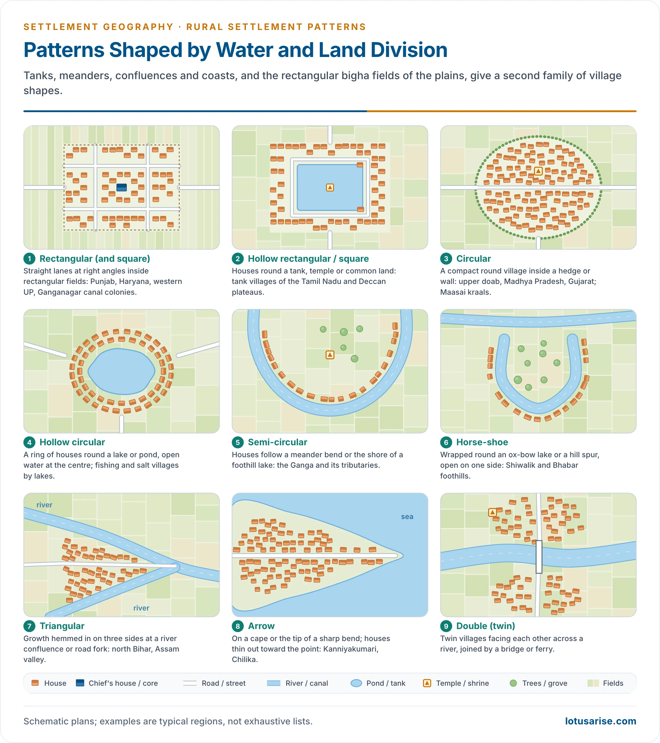
- Rectangular pattern:
- The village is rectangular, sometimes square, with straight lanes meeting at right angles. It is the commonest form of the fertile, intensively farmed northern plain.
- It marks high land capability, a high degree of nucleation and high population density, and it is the most common village pattern in India.
- The figure of more than 50% of the world’s population often quoted for it can hold only for village dwellers, since over half of humanity now lives in towns and cities.
- It is a legacy of land measurement in bighas: fields and orchards were laid out as rectangles, the lanes followed them, and rectangular plots fit rows of houses well.
- Internal plan:
- The zamindar’s or headman’s house stands at the centre, ringed by the houses of his own caste.
- Other castes live towards the edge, where the spacing between houses widens.
- Narrow, winding lanes link the quarters.
- India:
- Punjab, Haryana and western Uttar Pradesh.
- The Ganga–Yamuna doab and villages of eastern Uttar Pradesh and western Bihar.
- The Indira Gandhi Canal colonies of Ganganagar, Hanumangarh and Suratgarh, planned as rectangles.
- The deltas of the peninsular rivers.
- World: villages of south-eastern China, river villages of Myanmar, and planned villages in Germany, Russia, Israel and France.
- A rectangle seldom keeps its shape for long, because growth runs outward along the roads.
- Hollow rectangular pattern:
- Houses enclose a central open space: a pond, a tank, a temple, the site of an old building, or common land used by the whole village.
- These are typical wet-point settlements of the Tamil Nadu and Deccan plateaus.
- Square and hollow square patterns:
- Modified rectangles, with a high degree of compactness; the size and shape of the farmland decide them.
- The hollow square has a pond, temple or common space at its centre.
- Circular pattern:
- A compact, round village, a variant of the rectangular form, often within a hedge, wall or ring road, developed for social security and defence as well as for water and land capability.
- It grows round a pond, lake or crater, and sometimes round a temple or mosque.
- Fishing and salt-making communities settle round coastal lagoons and salt lakes in this form.
- India: the upper Ganga–Yamuna doab, Rohilkhand and the trans-Yamuna region, Madhya Pradesh, Punjab, Maharashtra and Gujarat. The kraals of the Maasai of Kenya and Tanzania are circular too.
- Hollow circular pattern: a ring of houses round a central lake, pond or tank, with open water at the centre.
- Semi-circular pattern:
- Houses follow a river meander, an ox-bow lake or a lake at the foot of a hill, forming a half-circle.
- It is found along the Ganga and its tributaries.
- Horse-shoe pattern:
- Houses wrap round an ox-bow lake, a spur or the foot of a hill, open on one side.
- Examples are villages of the Shiwalik and Bhabar belt (as near Haridwar) and tribal villages of Arunachal Pradesh.
- Triangular (arrow-head) pattern:
- Develops where two rivers or two roads converge, so growth is hemmed in on three sides and runs one way.
- Examples are the confluences of north Bihar and northern Assam, junctions where district roads meet highways in Madhya Pradesh, and the deltas of the Nile and Niger.
- Arrow pattern:
- Develops at the tip of a cape or at the sharp bend of a river or lake. Houses line the main road and become fewer towards the point.
- India: Kanniyakumari, the shores of Chilika lake, the Gulf of Khambhat, the Sonar river in Madhya Pradesh and the Burhi Gandak in Bihar.
- Double (twin) pattern: twin villages face each other across a river, joined by a bridge or ferry. They grow at river crossings of the plains.
Patterns Shaped by Relief
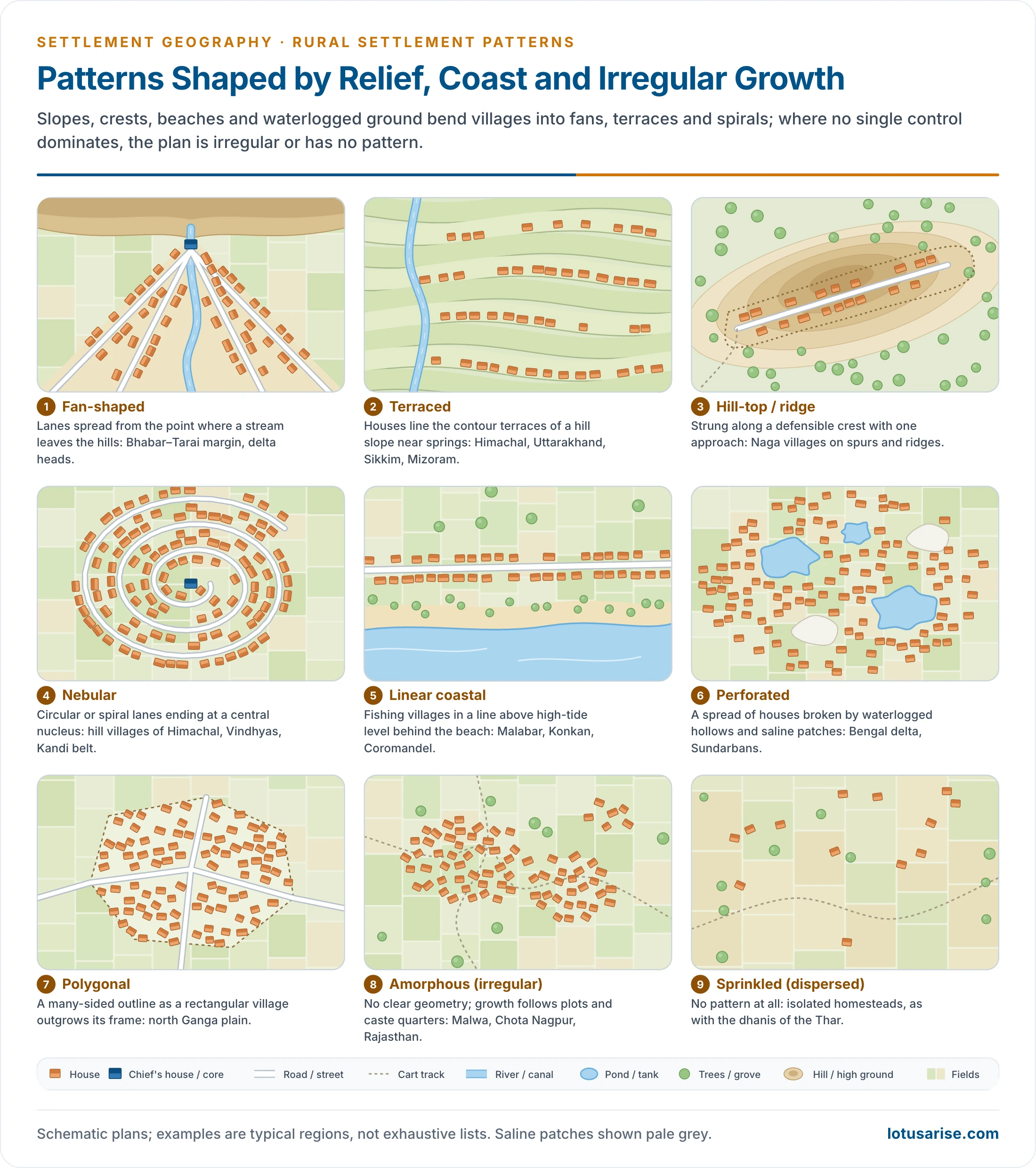
- Fan-shaped pattern: lanes spread out like a fan from the point where a stream leaves the hills or at the head of a delta, as along the Bhabar–Tarai margin.
- Terraced pattern:
- Houses line the terraces cut into hill slopes for cultivation, at different heights, usually near a spring or stream.
- Examples are the hill villages of Jammu and Kashmir, Himachal Pradesh, Uttarakhand, Sikkim, Arunachal Pradesh, Mizoram and the Western Ghats.
- Hill-top (ridge) pattern:
- Houses are strung along the edge of a summit or ridge, so the community can watch the approaches. This is a defensive form.
- Naga villages stand on hill-tops and spurs at about 1,000–2,000 m.
- Nebular pattern:
- Circular or spiral lanes end at a central nucleus, like a nebula.
- These villages are small and found in hilly, undulating ground: Himachal Pradesh, Uttarakhand, the Vindhyas, the Kandi belt of Jammu and Kashmir, and to a lesser extent the Ganga–Yamuna doab. Larger villages of the Shillong plateau grow this way.
- Outside India, it is described from upland villages of southern Germany.
Non-geometric and Transitional Patterns
- Perforated pattern:
- The spread of houses is broken by gaps: waterlogged hollows, saline crusts or sand.
- Examples are the Bengal delta and Sundarbans, cyclone- and flood-prone villages of Bangladesh, and villages of the northern Sahara with dunes between their hamlets.
- Polygonal pattern:
- A many-sided outline, a variant of the rectangle in transition. As a rectangular village grows, it becomes either polygonal or amorphous.
- It is found in the north Ganga plain.
- Amorphous (irregular) pattern:
- No definite shape; growth follows plots, caste quarters and paths. Many are semi-clustered villages loosening under centrifugal forces.
- India: south-western Uttar Pradesh, Punjab, Rajasthan, the Malwa and Chota Nagpur plateaus, Madhya Pradesh and Andhra Pradesh.
- Sprinkled pattern: the dispersed type, with isolated homesteads and no pattern at all, as with the dhanis of the Thar.
Distribution in India
- North-western plain (Punjab, Haryana, western Uttar Pradesh, the doab):
- Rectangular, checkerboard, star-like and radial villages, shaped by the dense road net, rectangular fields and canal colonisation.
- Middle and lower Ganga plain:
- Linear villages along levees, roads and dead river channels.
- Semi-circular and horse-shoe villages along meanders and ox-bows.
- Triangular villages at confluences, and perforated villages in the waterlogged delta.
- Himalayas:
- Linear belts in the foothills, terraced and nebular villages on the slopes, and horse-shoe villages in the Shiwalik and Bhabar belt.
- North-east:
- Hill-top villages in Nagaland, and linear villages along ridges, valleys and roads in Mizoram (Lushai) and Tripura (Chakma).
- Peninsula:
- Hollow rectangular tank villages on the Tamil Nadu and Deccan plateaus, and radial villages in Marathwada.
- Checkerboard villages on the southern plains, and amorphous villages on the Malwa and Chota Nagpur plateaus.
- Coasts: linear coastal fishing villages along the whole coastline; arrow villages at Kanniyakumari and Chilika.
| Pattern | Dominant control | Indian example |
|---|---|---|
| Linear | Road, canal, levee, coast | Konkan–Malabar coast, Brahmaputra levees |
| Rectangular, checkerboard | Rectangular fields, road grid | Punjab, Haryana, Ganganagar canal colonies |
| Radial, star-like | Converging roads at a node | Marathwada; Punjab–Haryana plain |
| Circular, hollow | Tank, pond, defence | Upper doab; Tamil Nadu tank villages |
| Triangular, arrow | Confluence, cape | North Bihar; Kanniyakumari, Chilika |
| Terraced, hill-top | Slope, crest, defence | Himachal Pradesh; Nagaland |
| Perforated | Waterlogging, salinity | Bengal delta, Sundarbans |
Measuring Pattern: The Nearest-Neighbour Index
Origin
- The nearest-neighbour index (NNI), written R or Rn, was devised by Philip J. Clark and Francis C. Evans (1954), ecologists, to describe the spacing of plants in a population.
- Geographers took it up in the quantitative revolution:
- Michael F. Dacey worked on the statistics of point patterns.
- Leslie J. King (1962) applied it to the spacing of urban settlements in twenty sample areas of the United States.
- Brian Birch (1967) applied it to dispersed rural settlement.
- It treats each settlement (or each house) as a point and asks whether the points are clustered, random or regular.
- The index tests the regular spacing predicted by central place theory.
Formula and Steps
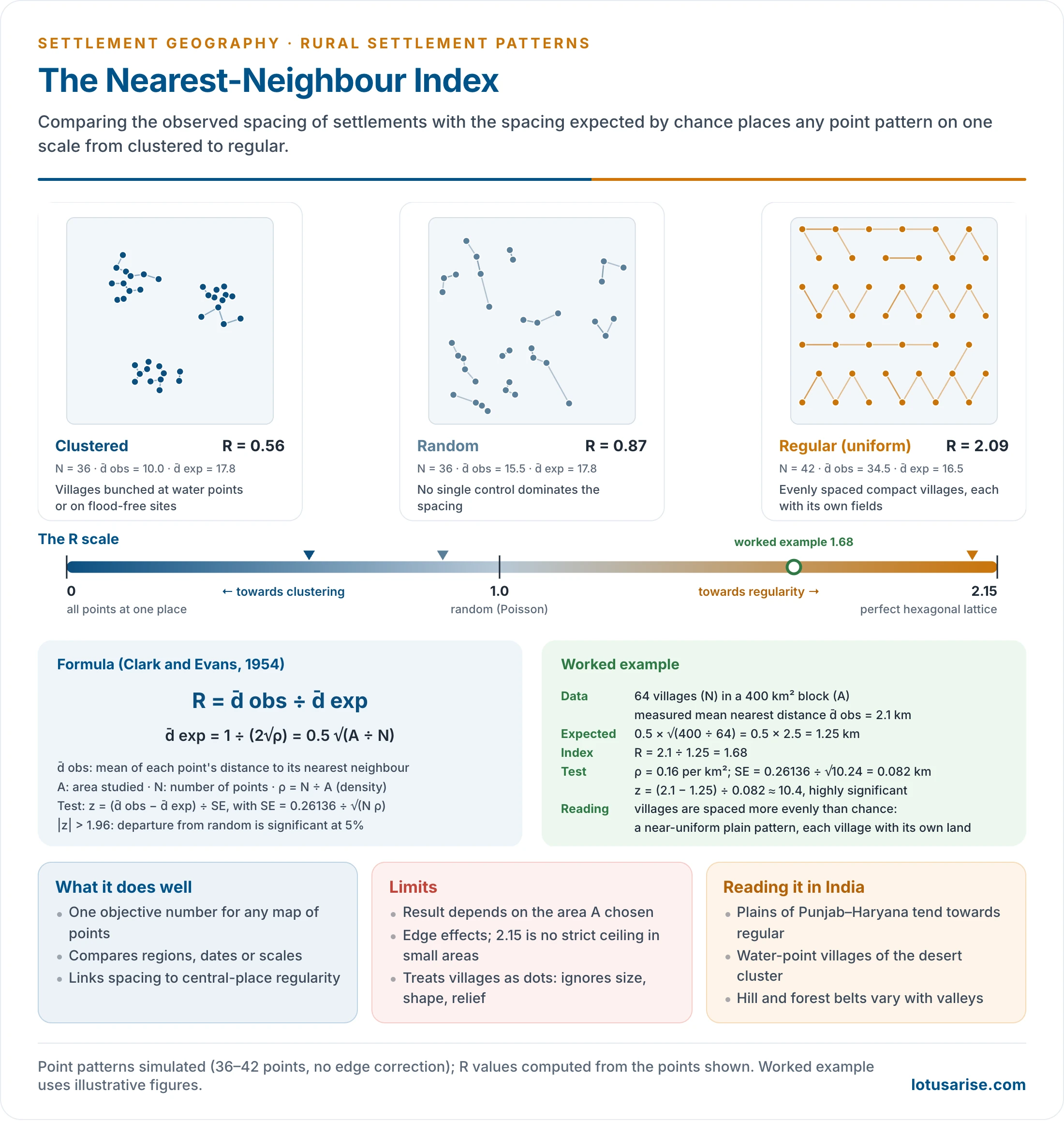
- R = d̄ obs ÷ d̄ exp
- d̄ obs = the observed mean distance from each point to its nearest neighbour: Σd ÷ N.
- d̄ exp = the mean distance expected in a random (Poisson) pattern of the same density: 1 ÷ (2√ρ) = 0.5 √(A ÷ N).
- A = the area studied; N = the number of points; ρ = N ÷ A, the density of points.
- Steps:
- Mark the settlements on a map of a defined area and count them (N).
- Measure the straight-line distance from each settlement to its nearest neighbour.
- Average these distances (d̄ obs).
- Compute the expected distance from the area and the number of points (d̄ exp).
- Divide the observed by the expected distance.
- Test whether R differs significantly from 1.
- Significance test:
- The standard error of the expected mean distance is SE = 0.26136 ÷ √(N ρ).
- z = (d̄ obs − d̄ exp) ÷ SE.
- A z beyond ±1.96 means the pattern departs from randomness at the 5% level; below −1.96 it is clustered, and above +1.96 it is regular.
The R Scale
- R = 0: all points at one place; perfect clustering.
- R = 1: a random pattern; observed and expected spacings are equal.
- R = 2.1491 (about 2.15): a perfectly regular pattern, each point at the same distance from six neighbours in a hexagonal (triangular) lattice. This is the arrangement of central places in Walter Christaller’s model.
- Values below 1 tend towards clustering; values above 1 tend towards regularity. Whether the departure is real depends on the significance test, not on R alone.
| R value | Pattern | Settlement meaning |
|---|---|---|
| 0 | Complete clustering | All houses or villages at one point |
| Below 1 | Clustered tendency | Nucleated villages, sites drawn to water or flood-free land |
| About 1 | Random | No single control on spacing |
| Above 1 | Regular tendency | Evenly spaced villages, each with its own land |
| 2.15 | Perfect hexagonal regularity | Theoretical central-place lattice |
Worked Example
- An area of 400 km² has 64 villages. The measured mean distance from each village to its nearest neighbour is 2.1 km.
- d̄ exp = 0.5 × √(400 ÷ 64) = 0.5 × 2.5 = 1.25 km.
- R = 2.1 ÷ 1.25 = 1.68.
- ρ = 64 ÷ 400 = 0.16 per km²; SE = 0.26136 ÷ √(64 × 0.16) = 0.26136 ÷ 3.2 = 0.082 km.
- z = (2.1 − 1.25) ÷ 0.082 ≈ 10.4, far beyond 1.96.
- Interpretation: the villages are spaced significantly more evenly than chance. This is a near-uniform plain pattern, in which each village commands its own share of land, as in the compact, evenly spaced villages of the Punjab–Haryana plain.
- With the same 64 villages but a mean nearest distance of 0.6 km, R would be 0.48: a clustered pattern, such as villages gathered at water points in a dry tract.
Uses
- It gives one objective number for a pattern, so regions, periods and scales can be compared.
- It tests the regular spacing predicted by central place theory and the effect of terrain, water and history on spacing.
- It complements the rank-size rule, which measures the size distribution of settlements. Together they describe both where settlements stand and how large they are.
- At the house scale it measures nucleation within a village; at the village scale it measures spacing over a region.
Limitations
- Choice of area (A): the same points give a different R if the boundary is drawn tighter or wider. A large empty margin makes a pattern look clustered.
- Edge (boundary) effect: points near the edge may have their true nearest neighbour outside the area. Corrections (such as a buffer zone or the Donnelly correction) are needed.
- For the same reason, in small finite areas R can slightly exceed 2.15, which is a theoretical value and not a strict ceiling.
- First neighbour only: R looks at one neighbour. A pattern of evenly spaced pairs or clusters can look regular or random. Second- and higher-order neighbour distances, or Ripley’s K-function, are used to detect this.
- Points without size: a hamlet and a large village count equally, and shape, function and population are ignored.
- Straight-line distance: it ignores relief, rivers and roads that govern real access.
- Shape blindness: R says how evenly points are spaced, not whether they form a line, a grid or a ring. Linear and rectangular patterns are not distinguished by it.
- Modern GIS adds quadrat analysis, kernel density and K-functions, but the NNI remains the standard first test of settlement spacing.
Changing Patterns
- Rural patterns are not static.
- New roads under the Pradhan Mantri Gram Sadak Yojana (from 2000), canals, electrification and the spread of non-farm work redraw them.
- Linear villages become T-shaped and cruciform, rectangular villages turn polygonal, and compact villages throw out ribbons along highways.
- Changing occupations, farming, technology and caste relations, cultural amalgamation and the diffusion of innovation are written into the village plan. The pattern thus records the changing socio-economic life of rural society.
Previous Year Questions
1992Citing suitable examples from India, explain the role of site and other physical factors in determining the types and patterns of rural settlements.1995Explain, with the help of suitable examples and illustrations, the distribution of various patterns of rural settlements in India.1998Discuss the geographical control of rural settlement pattern in India.1999Explain, with suitable examples and sketch maps the distribution of various patterns of rural settlements in India.2016Discuss the role of site in determining the types and patterns of rural settlements.2026Analyse the measuring patterns of settlement in relation to the Nearest Neighbour Index and Rank-Size-Rule in detail.





Great
Thanks HJP, Keep reading
Wow, you have written spectacular and it is very well organized too. Thank you for such a writing.
Thanks, Aditi for your very kinds words.
finally after reading three books on settlement, all doubt are clear here… great job
🙂 Thanks, Keep reading
you guys are doing great job! keep it up.
Excellent 👌👌👌👌👌
Want to thank you from the core of my heart… The topics I was trying to understand for past two years… Hv been explained in such lucid way…
Congratulations
Thank u so much for such a fantastic compilation of geography resources. This website always remains my first priority. YOUR EFFORTS ARE APPRECIABLE
The concept with picture,👌
thank u so much…
Thank you sir!