- The Pacific is the largest and deepest ocean. At about 165 million km² it covers nearly a third of the Earth’s surface, more than all the land together, and holds about half of the world’s ocean water.
- Ferdinand Magellan named it Mar Pacífico, the “peaceful sea”, in 1520 after a calm crossing.
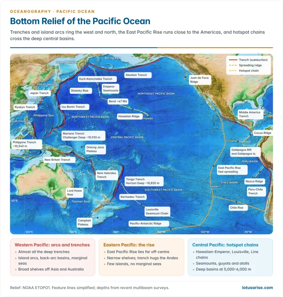
- Its floor differs from the Atlantic’s. It has no central ridge, a rim of trenches and island arcs, and thousands of seamounts scattered across deep central basins.
The Pacific Basin
Shape, size and depth
- The ocean is roughly triangular, with its apex at the Bering Strait and its base along Antarctica.
- It stretches about 15,500 km from north to south and about 19,800 km from Indonesia to Colombia along 5°N.
- The narrow, shallow Bering Strait gives it only a slight link with the Arctic, while it opens widely to the Southern Ocean.
- Its mean depth of about 4,000 m is the greatest of any ocean.
- Young fold mountains and volcanic arcs ring it on three sides, so the drop from coast to deep floor is steep.
- The andesite line, named by Patrick Marshall (1912), separates the basaltic ocean basin from the andesitic arcs and continental fragments of its margins.
- Relief is subdued east of about 150°W, where one broad rise dominates, and rugged in the west, where arcs, trenches, plateaus and island chains crowd together.
- The Pacific is shrinking. Rim subduction consumes its floor faster than ridges add to it, so it is the closing half of a Wilson cycle while the Atlantic opens.
- Its oldest crust, about 180 million years old, lies east of the Marianas.
- The floor is usually read in four regions:
| Region | Depth and relief | Main features |
|---|---|---|
| North Pacific | Deepest broad basin, 5,000–6,000 m | Few islands; Aleutian and Kuril–Kamchatka trenches; Emperor Seamounts |
| Central Pacific | Deep basins with many volcanic peaks | Most islands: volcanic chains, atolls, guyots |
| South-west Pacific | Very varied | Island arcs, trenches, marginal seas, broad shelves, submerged continent of Zealandia |
| South-east Pacific | Broad, smooth floor | East Pacific Rise; few islands; no marginal seas |
- In the central region the island chains run in sub-parallel lines, which Eduard Suess grouped as the “Oceanides”.
Relief of the Pacific Floor
Continental shelves
- The eastern shelf is narrow, averaging under 80 km and often under 20 km off parts of Peru and Chile.
- The Rockies and Andes run parallel to this active margin, and the slope plunges straight into a trench.
- Submarine canyons such as Monterey Canyon off California cut the short slope.
- The western shelf is broad, from about 160 km to over 1,000 km. Examples are the Sunda Shelf, the Sahul Shelf under the Arafura Sea, the Yellow and East China Seas, and the eastern Bering Sea.
- Large rivers such as the Huang He, Yangtze and Mekong built these shelves, and the arcs offshore shelter them.
- Many large islands stand on them: Borneo, Sumatra, Java, Taiwan and New Guinea are continental land cut off by a rise in sea level.
- At the last glacial maximum the Sunda and Sahul shelves were dry land, joining western Indonesia to Asia and New Guinea to Australia. The deep Wallace Line strait between them stayed water, which is why Asian and Australian animals stayed apart.
- The shelf break lies at about 100–200 m.
East Pacific Rise and other ridges
- The East Pacific Rise is the Pacific’s spreading ridge. Older literature called it the Albatross Plateau.
- It is off-centre, running close to the Americas from the Gulf of California to about 55°S, where it joins the Pacific–Antarctic Ridge.
- It is a broad, gentle swell 2–3 km high and well over 1,000 km wide without a deep rift valley, because it is the fastest-spreading ridge on Earth: more than 15 cm a year near Easter Island.
- Fast spreading also breaks it into small rotating microplates, such as the Easter and Juan Fernández microplates.
- Branches: the Galápagos Rift runs east between the Cocos and Nazca plates. The Chile Rise runs south-east to South America near 46°S, where the ridge itself is being subducted.
- North of the San Andreas transform, the Gorda and Juan de Fuca ridges continue the system off Oregon and Washington.
- Hydrothermal vents were first found on this system: on the Galápagos Rift by the submersible Alvin in 1977, and as hot black smokers at 21°N on the rise in 1979. Their life runs on chemosynthesis, not sunlight.
- Fracture zones offset the rise and run east–west for thousands of kilometres: Mendocino, Murray, Molokai, Clarion and Clipperton in the north; Easter Island and Challenger in the south.
- The floor between the Clarion and Clipperton zones holds the world’s richest polymetallic nodule field. The International Seabed Authority licenses exploration there, but in March 2026 the US agency NOAA accepted a company’s application to mine the zone under US law.
Aseismic ridges, rises and plateaus
- Most other Pacific ridges are not spreading centres. They are hotspot tracks, oceanic plateaus or submerged slivers of continent:
| Feature | Location | Nature |
|---|---|---|
| Cocos and Carnegie ridges | Galápagos to Costa Rica and Ecuador | Tracks of the Galápagos hotspot |
| Nazca Ridge | Off southern Peru | Hotspot track, now being subducted |
| Hawaiian Ridge and Emperor Seamounts | North Pacific | Hotspot chain about 6,200 km long |
| Louisville Seamount Chain | South Pacific, meeting the Tonga–Kermadec trench | Hotspot chain |
| Mid-Pacific Mountains | West of Hawaii | Cretaceous volcanic range capped by guyots |
| Ontong Java Plateau | North of the Solomon Islands | Largest oceanic plateau, about 1.5 million km², erupted about 120 million years ago |
| Manihiki Plateau | North-east of Samoa | Oceanic plateau of the same age |
| Shatsky Rise | East of Japan | Cretaceous oceanic plateau |
| Lord Howe Rise, Norfolk Ridge, Campbell Plateau, Chatham Rise | Around New Zealand | Submerged continental crust of Zealandia, a continent about 94% under water (described 2017) |
| Fiji Plateau | Around Fiji | Shallow platform carrying the Fiji islands |
| Kyushu–Palau Ridge | Philippine Sea | Remnant (dead) island arc |
| Eauripik Rise and Caroline Ridge | North of New Guinea | Volcanic rises dividing the Caroline basins |
| Macquarie Ridge | South of New Zealand | Australian–Pacific plate boundary |
- Hawaii sits on a swell. Heat from the hotspot lifts the floor around the Hawaiian Ridge into a rise more than 1,000 km wide, so the islands crown a broad bulge rather than flat abyssal floor.
- The Ontong Java, Manihiki and Hikurangi plateaus were probably one giant plateau that later rifted apart, the largest volcanic outpouring known on Earth.
Ocean basins
- Ridges and rises divide the floor into deep basins at 4,000–6,000 m. Abyssal hills dominate them rather than flat plains, because the rim trenches trap land sediment.
- True abyssal plains form only where no trench blocks the supply, as in the Bellingshausen Basin off West Antarctica and the Aleutian Basin.
| Basin | Location | Notes |
|---|---|---|
| North-west and North-east Pacific basins | Either side of the Hawaiian Ridge | Broadest and deepest, 5,000–6,000 m |
| Central Pacific Basin | Between Hawaii and the Line Islands | Deep floor studded with seamounts |
| Philippine Basin | Philippine Sea, east of the Philippines | 5,000–6,000 m; split by the Kyushu–Palau Ridge |
| East and West Caroline basins | North of New Guinea | 4,000–5,000 m |
| North and South Fiji basins | Between Vanuatu and Tonga | Young back-arc basins |
| Tasman (East Australian) Basin | Between Australia and the Lord Howe Rise | Opened as Zealandia rifted from Australia |
| South-west Pacific Basin | East of Tonga–Kermadec | Long basin crossed by the Louisville chain |
| Peru and Chile basins | East of the East Pacific Rise | Nazca Plate floor |
| Pacific–Antarctic Basin | South-west of Chile, about 40–60°S | Cold floor beside the Pacific–Antarctic Ridge |
| Bellingshausen Basin | Off West Antarctica | Abyssal plain fed by glacial sediment |
| Aleutian Basin | Bering Sea | About 4,000 m, trapped behind the Aleutian arc |
Sediments of the deep floor
- Red clay covers the largest share of the deep Pacific, especially the central North Pacific, because the floor lies below the carbonate compensation depth and far from land.
- The Pacific’s CCD is shallower, about 4,200–4,500 m, than the Atlantic’s of about 5,000 m, since its old, cold deep water is richer in CO₂.
- Calcareous ooze caps the East Pacific Rise and other high ground above the CCD.
- Siliceous ooze follows belts of high productivity: radiolarian ooze under the equatorial upwelling and diatom ooze in the far north and the Southern Ocean.
- Manganese nodules grow very slowly on the red clay, which is why the Clarion–Clipperton floor is so rich in them. The full pattern belongs with ocean deposits.
Trenches and deeps
- The Pacific holds almost all the world’s deep trenches, mostly on its western rim, and none in mid-ocean.
- They lie on the ocean side of island arcs or parallel to coastal mountains, marking subduction zones of the Pacific, Nazca and Cocos plates.
- The deepest trenches lie in the west because the plate sinking there is the oldest, coldest and densest; the young Nazca Plate makes a shallower Peru–Chile Trench.
- The Challenger Deep in the Mariana Trench, about 10,935 m (2021 sonar analysis), is the deepest point on Earth. Jacques Piccard and Don Walsh first reached it in the Trieste in 1960.
- The Mariana Trench is a crescent about 2,550 km long but only about 70 km wide.
- China’s crewed submersible Fendouzhe reached about 10,909 m there in November 2020.
| Trench | Location | Deepest point (approx.) |
|---|---|---|
| Mariana | East and south of the Mariana Islands | 10,935 m (Challenger Deep) |
| Tonga | East of Tonga | 10,820 m (Horizon Deep) |
| Philippine | East of Mindanao and Samar | 10,540 m (Emden Deep) |
| Kermadec | North-east of New Zealand | 10,050 m |
| Izu–Bonin | South of Tokyo | 9,830 m |
| Kuril–Kamchatka | Off the Kurils and Kamchatka | 9,600 m |
| New Britain | Solomon Sea | 9,140 m |
| Japan | East of Honshu | 8,410 m |
| Peru–Chile (Atacama) | Off western South America | 8,055 m (Richards Deep) |
| Aleutian | South of the Aleutian Islands | 7,820 m |
| Middle America | Off Mexico and Central America | 6,670 m |
| Others | Ryukyu, Yap, Palau, New Hebrides (Vanuatu), Bougainville | — |
- Below about 6,000 m lies the hadal zone, found almost only in Pacific trenches. Life persists there: a snailfish filmed at 8,336 m in the Izu–Ogasawara Trench in 2022 is the deepest fish on record.
Island arcs and the Ring of Fire
- Island arcs are curved chains of volcanic islands, convex to the ocean, about 100–200 km behind a trench: the Aleutians, Kurils, Japan, Izu–Bonin, Marianas, Philippines, Solomons, Vanuatu, Tonga and Kermadecs.
- Older literature called these looping chains festoons. Neighbouring arcs meet at sharp cusps, as where the Kuril and Izu–Bonin arcs meet Japan.
- How they form:
- The old, cold Pacific Plate bends at an outer rise and sinks into the trench.
- At about 100 km depth the slab releases water, which melts the mantle wedge above it; the magma builds the arc.
- Earthquakes trace the slab to about 700 km: the Wadati–Benioff zone, after Kiyoo Wadati and Hugo Benioff.
- Where the slab rolls back, a back-arc basin opens behind the arc, as in the Mariana Trough, the Sea of Japan and the Fiji basins.
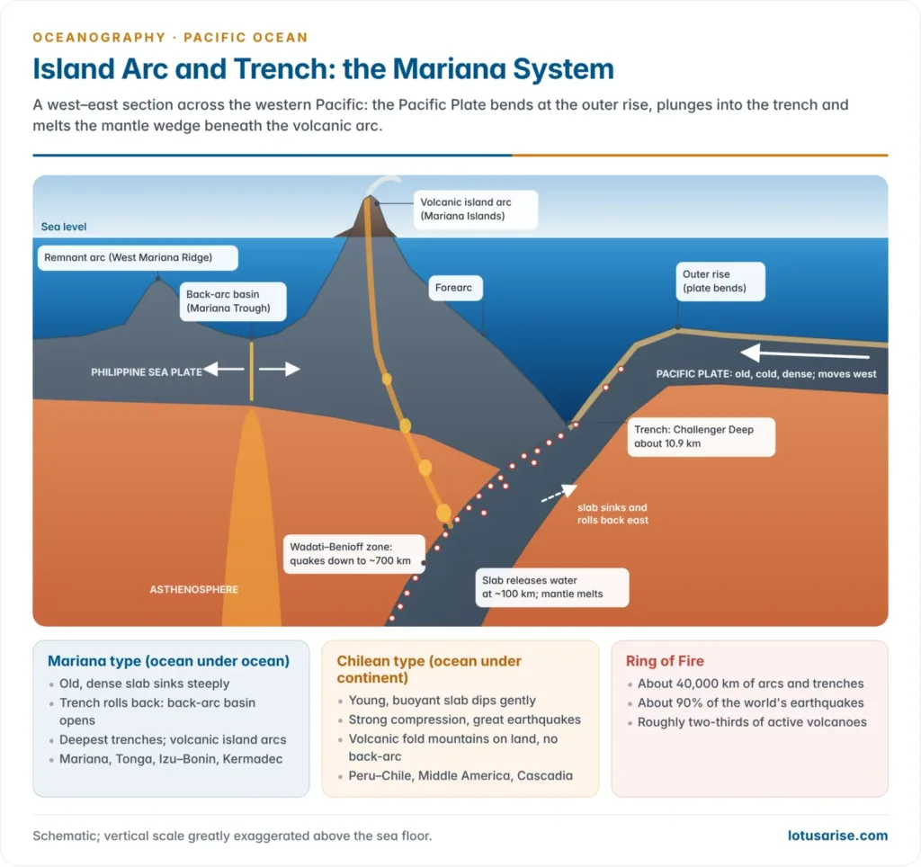
- Seiya Uyeda and Hiroo Kanamori (1979) distinguished two styles of Pacific subduction:
| Feature | Mariana type | Chilean type |
|---|---|---|
| Slab | Old, dense; dips steeply | Young, buoyant; dips gently |
| Stress on upper plate | Tension | Compression |
| Behind the arc | Back-arc basin opens | Fold mountains, no back-arc basin |
| Great earthquakes | Fewer | Frequent (Chile 1960, Mw 9.5) |
| Examples | Marianas, Tonga, Izu–Bonin | Peru–Chile, Middle America |
- The arcs form the Ring of Fire, a belt about 40,000 km long with roughly two-thirds of the world’s active volcanoes and about 90% of its earthquakes. It breaks in the South Pacific, where the boundaries are spreading ridges.
- Recent events: the 2011 Tōhoku earthquake (Mw 9.0–9.1) on the Japan Trench; the Hunga Tonga–Hunga Haʻapai eruption of January 2022, whose plume reached about 57 km; and the Mw 8.8 Kamchatka earthquake of July 2025 on the Kuril–Kamchatka Trench, the strongest since Tōhoku.
- This is why earthquakes, volcanoes and tsunamis crowd the Pacific margin. India’s Andaman–Nicobar arc, with the Barren Island volcano, is the same arc–trench type on the Indian Ocean side.
- Warning systems grew from Pacific disasters. The Pacific Tsunami Warning Center in Hawaii dates from 1949, after the 1946 Aleutian tsunami; the 1960 Chile tsunami crossed the whole ocean to kill people in Japan. India’s INCOIS centre at Hyderabad, set up in 2007 after the 2004 tsunami, now serves the Indian Ocean the same way.
Seamounts, guyots and hotspot chains
- The Pacific has more seamounts than any other ocean, because its floor is wide, old and crossed by many hotspot tracks.
- A seamount is a submarine volcano rising 1,000 m or more above the floor with a pointed or rounded summit; a guyot is one whose summit was planed flat at sea level before it sank.
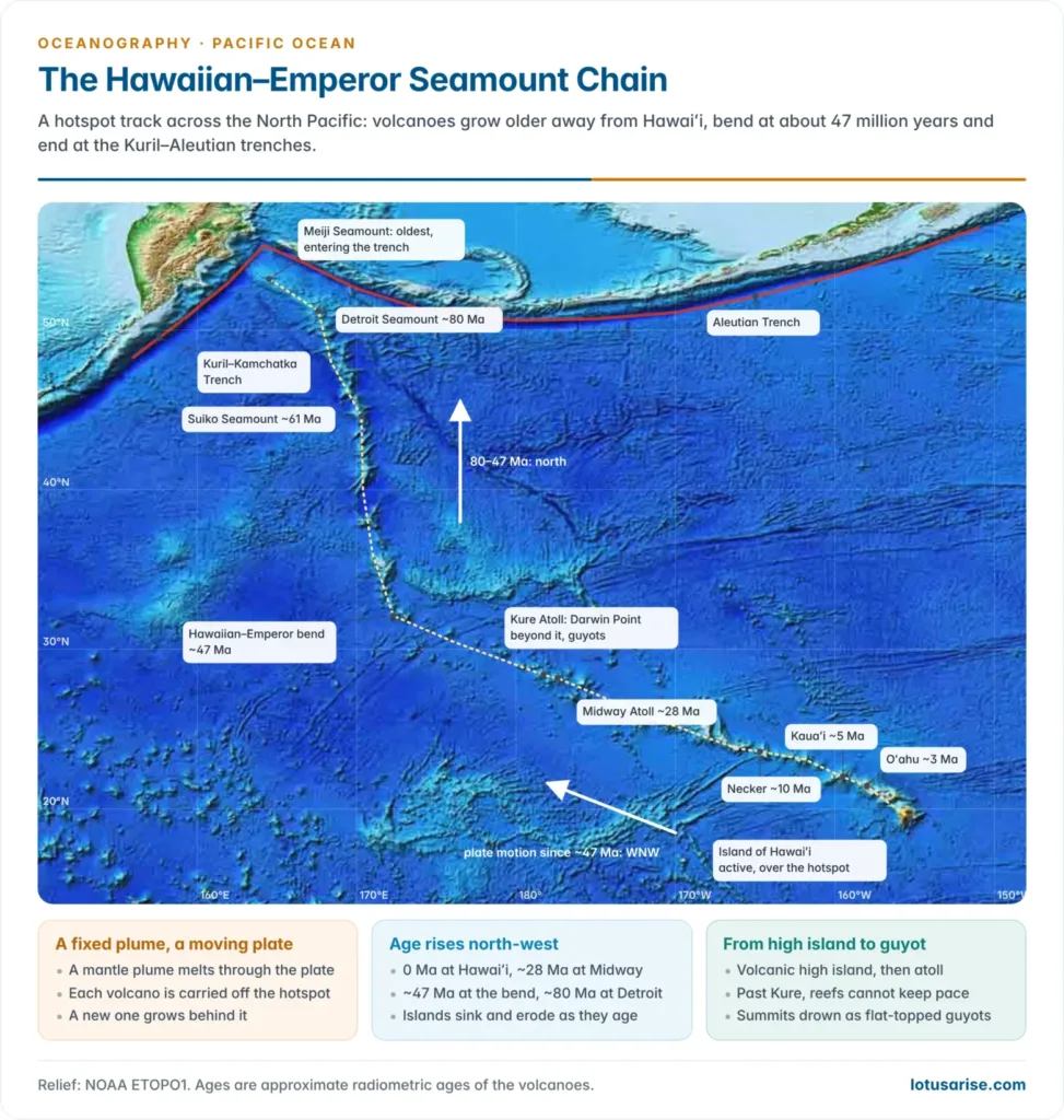
- The Hawaiian–Emperor chain is the classic hotspot track: about 6,200 km long, with more than 80 volcanoes.
- Age rises north-westward, from the active Island of Hawaiʻi and the growing seamount Kamaʻehuakanaloa (formerly Lōʻihi) to about 28 million years at Midway and 80 million years at Detroit Seamount.
- The bend at about 47 million years is usually read as a change in plate direction; recent work adds southward drift of the hotspot itself.
- Its northern tip, near Meiji Seamount, is entering the Kuril–Aleutian trench junction.
- The Louisville, Line, Society, Austral–Cook and Tuamotu chains trend north-west in parallel.
- Guyots crowd the central and western Pacific, in the Mid-Pacific Mountains and the Marshall Islands. Harry Hammond Hess (1946) first described them there, about 160 between Hawaii and the Marianas.
- They are islands planed at sea level that sank as the plate cooled. Beyond Kure Atoll (the Darwin Point), reefs cannot keep pace with subsidence, so the older Hawaiian summits are drowned guyots.
- The flanks of old western Pacific seamounts, such as the Magellan Seamounts, carry cobalt-rich crusts, and most of the seabed authority’s crust exploration contracts lie there.
Islands and Marginal Seas
Islands of the Pacific
- The Pacific has about 25,000 islands, more than all other oceans combined, though their total area is small. Most lie between the tropics in the west and centre.
- The eastern Pacific is nearly empty, with only the Galápagos, Clipperton, Revillagigedo, Juan Fernández and Easter Island.
- By origin there are three types:
| Type | Origin | Examples |
|---|---|---|
| Continental islands | Fragments or edges of continents; fold mountains on continental crust | Japan, Taiwan, New Guinea, New Zealand, New Caledonia |
| High volcanic islands | Arc volcanoes over subduction zones, or hotspot volcanoes in mid-plate | Arc: Aleutians, Kurils, Marianas, Tonga, Vanuatu. Hotspot: Hawaii, Galápagos, Samoa, Society, Marquesas |
| Low coral islands | Reefs on subsiding volcanoes: atolls and reef islands | Marshall Islands, Kiribati, Tuvalu (Funafuti), Tuamotu |
- Mauna Kea on Hawaiʻi rises about 4,207 m above sea level but more than 10,000 m from its base on the floor, making it the tallest mountain on Earth measured base to summit. Its neighbour Mauna Loa is the largest active volcano by volume.
- Drilling on Enewetak Atoll in 1952 passed through about 1,400 m of reef limestone before striking basalt, confirming Charles Darwin’s subsidence explanation of atolls.
- By culture the islands form Melanesia (New Guinea to Fiji), Micronesia (Marianas, Carolines, Marshalls, Kiribati) and Polynesia, the triangle of Hawaii, New Zealand and Easter Island.
- Atoll nations are the most exposed to sea-level rise. Most of Tuvalu lies within a few metres of the sea, and its Falepili Union treaty with Australia, in force since August 2024, offers a migration pathway to its citizens. India’s Lakshadweep atolls face the same threat.
Marginal seas of the western Pacific
- Almost all Pacific marginal seas lie in the west. The east has only the Gulf of California, opened as the East Pacific Rise entered the continent and tore Baja California away from Mexico, and the open Gulf of Alaska.
- They are of two kinds:
- Deep back-arc and trapped basins behind island arcs, such as the Sea of Japan, South China Sea, Philippine Sea and the Sulu, Celebes and Banda Seas.
- Shallow shelf seas on drowned margins, such as the Yellow Sea (mean depth under 50 m), the Java and Arafura Seas and the Gulf of Carpentaria.
| Sea | Enclosed by | Character |
|---|---|---|
| Bering Sea | Alaska, Siberia and the Aleutian arc | Broad northern shelf; deep Aleutian Basin in the south |
| Sea of Okhotsk | Siberia, Kamchatka and the Kuril arc | Mostly shelf; deep Kuril Basin in the south |
| Sea of Japan | Korea, Russia and the Japan arc | Back-arc basin, about 3,700 m at its deepest |
| Yellow Sea | China and Korea | Very shallow shelf sea |
| East China Sea | China, Taiwan and the Ryukyu arc | Wide shelf; Okinawa Trough behind the arc |
| South China Sea | China, Vietnam, Borneo and the Philippines | Deep oceanic basin flanked by the Sunda Shelf |
| Sulu and Celebes Seas | Between the Philippines and Borneo | Small deep basins, the Celebes over 6,000 m |
| Banda Sea | Eastern Indonesia | Holds the Weber Deep, over 7,000 m, Earth’s deepest forearc basin |
| Philippine Sea | Japan, the Philippines and the Izu–Bonin–Mariana arc | Largest marginal sea; on its own plate |
| Coral and Tasman Seas | Australia, New Guinea, Vanuatu and New Zealand | Deep basins between Australia and Zealandia |
- The reefs and shoals of these seas carry political weight. The Spratly and Paracel features of the South China Sea are disputed, and a tribunal under the Law of the Sea ruled in 2016 that none of the Spratly features is a full island able to claim an EEZ.
Significance of the Pacific Floor
Pacific and Atlantic floors compared
| Feature | Pacific | Atlantic |
|---|---|---|
| Spreading ridge | East Pacific Rise: off-centre, smooth, fast | Mid-Atlantic Ridge: central, rifted, slow |
| Margins | Mostly active: trenches and arcs | Mostly passive: wide shelves and rises |
| Trenches | Many, the deepest on Earth | Only Puerto Rico and South Sandwich |
| Deep floor | Abyssal hills, seamounts, guyots | Broad abyssal plains fed by sediment |
| Marginal seas | Many, mostly back-arc basins in the west | Fewer, mostly shelf and inland seas |
| Basin trend | Shrinking | Widening |
Why the relief matters
- Hazards: the active rim makes the Pacific the world’s main source of great earthquakes, explosive eruptions and ocean-wide tsunamis.
- Resources: nodules in the Clarion–Clipperton zone, crusts on western seamounts and seafloor massive sulphides at back-arc vents, as in the Manus Basin off Papua New Guinea, make it the centre of the deep-sea mining debate. The broad western shelves hold oil, gas and rich fisheries.
- Climate and circulation: the island chains and ridges steer deep water, and the wide equatorial floor and narrow eastern shelf shape the upwelling off Peru that weakens during El Niño.
- Science: the Pacific floor gave the key proofs of plate tectonics: hotspot age progressions, guyots, Benioff zones, fast-spreading ridges and the first vent ecosystems.