

- The United Nations Convention on the Law of the Sea (UNCLOS), often called the “constitution for the oceans”, sets the legal order for every use of the sea: navigation, fishing, mining, research, environmental protection and dispute settlement.
- Adopted in 1982 and in force since 16 November 1994, it has 172 parties (171 states and the European Union, 2026). India ratified it on 29 June 1995; the United States has never ratified it, though it follows most of its rules as customary law.
- Its central idea is zoning: a coastal state’s powers shrink step by step away from the coast, from sovereignty near the shore to sovereign rights over resources offshore and open freedoms on the high seas.
Evolution and Structure of UNCLOS
From freedom of the seas to a single treaty
- The law grew out of a contest between open and closed seas, settled for centuries by a narrow coastal belt. After 1945 coastal states pushed their claims outward, and the idea of the deep sea bed as shared property launched the third conference.
| Year | Milestone |
|---|---|
| 1609 | Hugo Grotius, Mare Liberum: the seas are free to all |
| 1635 | John Selden, Mare Clausum: the seas can be owned |
| 1702 | Cornelis van Bynkershoek’s cannon-shot rule, later fixed as a 3 nm belt |
| 1945 | Truman Proclamation claims the resources of the US continental shelf |
| 1947 | Chile and Peru claim 200 nm for fisheries |
| 1958 | UNCLOS I (Geneva): four conventions on the territorial sea and contiguous zone, high seas, continental shelf, and fishing |
| 1960 | UNCLOS II fails to agree the breadth of the territorial sea |
| 1967 | Arvid Pardo of Malta asks the UN to treat the deep sea bed as the “common heritage of mankind” |
| 1973–82 | UNCLOS III; the Convention opens for signature at Montego Bay, Jamaica, on 10 December 1982 |
| 1994 | Entry into force, a year after the 60th ratification (Guyana) |
- Two pressures drove the outward push. Fishing fleets clashed over distant grounds, as in the Cod Wars between Iceland and Britain (1958–76), and offshore oil, first drilled out of sight of land in the Gulf of Mexico in 1947, made the sea bed worth claiming.
- UNCLOS III worked by consensus and treated the text as a package deal: the 12 nm territorial sea and the 200 nm EEZ were traded for guaranteed transit passage through straits, which the naval powers wanted, and a shared regime for the deep sea bed, which the developing countries of the Group of 77 wanted.
Structure and implementing agreements
- The Convention has 320 articles in 17 parts and 9 annexes. The UN Secretary-General is its depositary, the UN Division for Ocean Affairs and the Law of the Sea services it, and a yearly Meeting of States Parties elects tribunal judges and commission members.
| Part | Subject |
|---|---|
| II, III, IV | Territorial sea and contiguous zone; straits; archipelagic states |
| V, VI, VII | EEZ; continental shelf; high seas |
| VIII, X | Islands; land-locked states |
| XI | The Area and the ISA |
| XII, XIII, XIV | Marine environment; scientific research; transfer of technology |
| XV | Settlement of disputes |
- Three implementing agreements extend it:
| Agreement | Adopted | Purpose |
|---|---|---|
| Part XI Agreement | 1994 | Rewrote the deep-sea-bed mining regime to win over industrial states |
| UN Fish Stocks Agreement | 1995 | Straddling and highly migratory stocks; precautionary approach |
| BBNJ (High Seas) Agreement | 2023 | Marine biodiversity beyond national jurisdiction; in force 17 January 2026 |
Maritime Zones
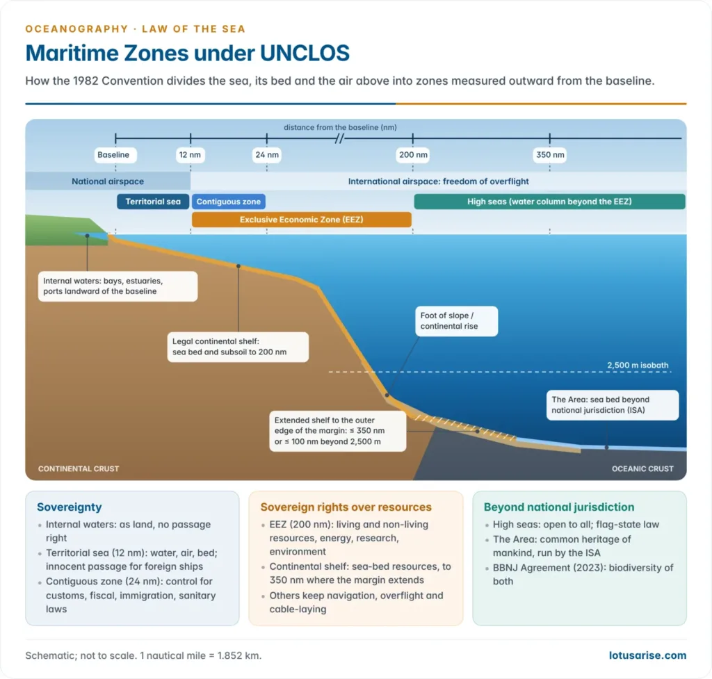
- Every zone is measured from the baseline, normally the low-water line.
- Straight baselines may join headlands and fringing islands on deeply indented or unstable coasts, and a bay may be closed by a line of up to 24 nm across its mouth.
- Archipelagic states such as Indonesia and the Philippines may join their outermost islands, provided the water-to-land ratio inside lies between 1:1 and 9:1 and no line exceeds 100 nm (a few may reach 125 nm). The enclosed archipelagic waters are sovereign but open to passage.
- Water landward of the baseline is internal waters: ports, river mouths and bays under full sovereignty and with no right of passage.
- One nautical mile is 1,852 m, about one minute of latitude.
| Zone | Limit from baseline | Coastal state’s powers | Rights of other states |
|---|---|---|---|
| Territorial sea | 12 nm | Sovereignty over water, sea bed and airspace | Innocent passage for ships, not aircraft |
| Contiguous zone | 24 nm | Prevent and punish breaches of customs, fiscal, immigration and sanitary laws | High-seas freedoms otherwise |
| Exclusive Economic Zone | 200 nm | Sovereign rights over living and non-living resources and energy; jurisdiction over research, artificial islands and the marine environment | Navigation, overflight, cables and pipelines |
| Continental shelf | 200 nm, or the outer edge of the margin up to 350 nm | Sovereign rights over sea-bed resources and sedentary species | Water above keeps its own status |
| High seas | Beyond the EEZ | Flag state controls its own ships | Navigation, overflight, fishing, research, cables |
| The Area | Sea bed beyond national shelves | None; managed by the ISA | Minerals are common heritage of mankind |
Rights of passage
| Regime | Where | Key rule |
|---|---|---|
| Innocent passage | Territorial sea | Continuous, expeditious, not prejudicial to peace or security; submarines surface; can be suspended temporarily |
| Transit passage | Straits used for international navigation (Hormuz, Malacca) | Ships and aircraft; cannot be suspended |
| Archipelagic sea-lanes passage | Inside archipelagic baselines | Along designated lanes |
| Freedom of navigation | EEZ and high seas | Subject only to resource and environmental rules |
- Fishing, spying, weapons practice and wilful pollution make passage not innocent.
- The contiguous zone gives enforcement control only, not sovereignty or airspace.
Exclusive Economic Zone
- The EEZ is a sui generis zone, neither territorial sea nor high seas. It now places about 90% of the world’s commercial fish catch and most offshore oil and gas under national control.
- Rights come with duties. The coastal state fixes a total allowable catch, must prevent over-exploitation, and should give other states access to any surplus it cannot harvest itself.
- Land-locked and geographically disadvantaged states have a claim to a fair share of that surplus in their region, and a right of access to and from the sea through transit states without taxes on their traffic.
- Islands get full zones, but rocks that cannot sustain human habitation or economic life get no EEZ or shelf (Article 121(3)). Artificial islands get no zones at all.
Continental shelf and the CLCS
- The legal continental shelf is not the geological continental shelf. It is the natural prolongation of the land territory to the outer edge of the continental margin, or 200 nm, whichever is greater.
- Beyond 200 nm the outer edge is fixed from the foot of the continental slope, the point of sharpest change in gradient at its base, by either of two lines:
- the sediment-thickness line, where sediment is at least 1% as thick as the distance back to the foot of the slope;
- the distance line, 60 nm beyond the foot of the slope.
- The result may not exceed 350 nm, or 100 nm beyond the 2,500 m isobath.
- Such claims go to the Commission on the Limits of the Continental Shelf (CLCS), 21 experts in geology, geophysics and hydrography; limits set on its recommendations are final and binding.
- A state had ten years from joining to make its claim; for early parties, including India, the deadline was 13 May 2009.
- Mining revenue beyond 200 nm is shared through the ISA, rising to 7% of production value (Article 82).
Delimitation between neighbours
- Where zones overlap, the territorial sea is split by the median line unless historic title or special circumstances apply. For the EEZ and shelf, UNCLOS asks only for an equitable solution (Articles 74 and 83).
- Courts now follow three steps: draw a provisional equidistance line, shift it for relevant circumstances such as a concave coast, then test that the result is not grossly disproportionate to coastline lengths.
- The first ITLOS boundary case, Bangladesh v Myanmar (2012), and the Bay of Bengal award against India (2014) both moved the line to offset the concavity of Bangladesh’s coast.
High seas and the Area
- On the high seas a ship obeys its flag state, except for crimes such as piracy.
- Piracy (Article 101) is private violence by one ship against another on the high seas or in an EEZ. The same act inside a territorial sea is armed robbery at sea, a matter for the coastal state.
- The Area is the sea bed beyond national jurisdiction. Its minerals are the common heritage of mankind, licensed by the International Seabed Authority.
Marine environment, research and technology
- Part XII (Articles 192–237) lays a general duty on every state to protect and preserve the marine environment, and names six sources of pollution:
- land-based sources;
- sea-bed activities under national jurisdiction;
- activities in the Area;
- dumping;
- vessels;
- the atmosphere.
- Enforcement is shared:
- the flag state enforces ship standards everywhere;
- the port state may act against a ship in its port for discharges elsewhere;
- the coastal state may act in its own waters and EEZ.
- Ship rules are written through the International Maritime Organization, as in MARPOL.
- Marine scientific research in another state’s EEZ or on its shelf needs that state’s consent, which should normally be given for peaceful research. Part XIV asks states to transfer marine technology on fair and reasonable terms.
Institutions and Recent Developments
| Institution | Seat | Role |
|---|---|---|
| International Seabed Authority (ISA) | Kingston, Jamaica | Licenses exploration in the Area; drafting a Mining Code for exploitation |
| International Tribunal for the Law of the Sea (ITLOS) | Hamburg | 21 judges; disputes, prompt release of ships, advisory opinions; Seabed Disputes Chamber |
| Commission on the Limits of the Continental Shelf (CLCS) | New York | Recommends outer limits of shelves beyond 200 nm |
- The ISA works through an Assembly of all parties, a 36-member Council, a Legal and Technical Commission and a Secretariat. In March 2026 it had 31 exploration contracts in force: 19 for nodules, 8 for sulphides and 4 for cobalt crusts.
- The Mining Code for commercial exploitation is still unfinished after more than a decade of drafting, and a 2025 US executive order to license sea-bed mining under domestic law, outside the ISA, has sharpened the debate.
- Dispute settlement (Part XV) is compulsory but flexible. A state may choose ITLOS, the International Court of Justice or arbitration; if two parties have chosen differently, arbitration applies.
- States may opt out of boundary, military and some law-enforcement disputes (Article 298); China did so in 2006.
- Even then, boundary disputes can be sent to compulsory conciliation. Its first use, by Timor-Leste against Australia (2016), produced the Timor Sea boundary treaty of 6 March 2018.
Recent cases and opinions
| Case | Year | Outcome |
|---|---|---|
| Bay of Bengal arbitration (Bangladesh v India) | 2014 | Bangladesh received about 19,467 of the 25,602 sq km in dispute; India accepted the award |
| South China Sea arbitration (Philippines v China) | 2016 | No legal basis for historic rights inside the nine-dash line; no Spratly feature generates an EEZ; China rejects the award |
| ITLOS climate advisory opinion | 2024 | Unanimous: greenhouse-gas emissions are marine pollution; stringent due diligence required beyond the Paris Agreement |
| ICJ climate advisory opinion | 2025 | Similar duties under general international law |
| M/T Heroic Idun (Marshall Islands v Equatorial Guinea) | 2026 | Seizure on an unfounded piracy suspicion breached freedom of navigation; compensation ordered |
| Nauru Ocean Resources and Tonga Offshore Mining v ISA | 2026 | Two nodule contractors challenged an ISA inquiry into their conduct before the Seabed Disputes Chamber, while the Mining Code is still unfinished |
- The 2024 ITLOS opinion matters most: it turns UNCLOS’s pollution articles into climate obligations for every party.
- Sea-level rise threatens baselines drawn on low-water lines. The Pacific Islands Forum declared in 2021 that its members’ zones stay fixed once notified, and the 2025 ICJ opinion held that states need not update their baseline charts after the coast retreats.
BBNJ (High Seas) Agreement
- The High Seas Treaty covers the two-thirds of the ocean beyond national jurisdiction, whose biodiversity UNCLOS left largely unregulated.
- It was adopted on 19 June 2023, reached its 60th ratification on 19 September 2025 and entered into force on 17 January 2026. It passed 100 parties in September 2026, and the first Conference of the Parties meets in New York on 11–22 January 2027.
- Its four pillars are marine genetic resources with benefit-sharing, area-based tools including high-seas protected areas, environmental impact assessments, and capacity building and technology transfer.
- India signed in September 2024; ratification awaits a domestic legal framework, on which the Ministry of Earth Sciences began consultations in December 2025.
India and the Law of the Sea
India’s maritime zones and claims
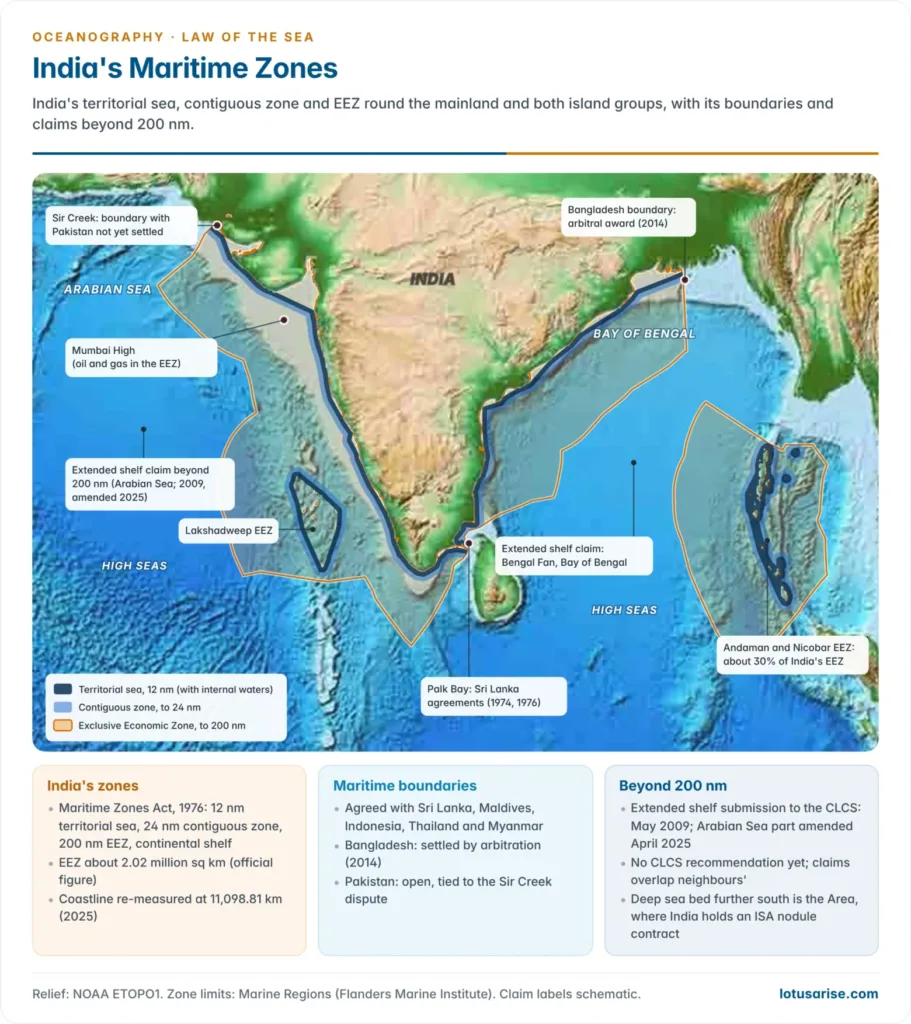
- India fixed its zones in the Maritime Zones Act, 1976, before UNCLOS was signed.
- The Act requires foreign warships to give prior notice before entering the territorial sea, a stricter rule than UNCLOS’s plain innocent passage.
- The official EEZ is about 2.02 million sq km, about 30% of it round the Andaman and Nicobar Islands.
- A 2025 re-measurement put the coastline at 11,098.81 km, against the 7,516.6 km used since the 1970s.
- Boundaries are agreed with Sri Lanka (1974, 1976), the Maldives, Indonesia, Thailand and Myanmar, and with Bangladesh by arbitration. The Pakistan boundary remains open over Sir Creek.
- The 1974 agreement treats the Palk Bay as historic waters shared by the two countries and placed Katchatheevu on the Sri Lankan side. Indian fishers who cross the line, many using bottom trawlers, remain a standing irritant.
- Extended shelf: India’s partial submission to the CLCS (11 May 2009) covers areas beyond 200 nm in the Arabian Sea and on the Bengal Fan, where the thick fan sediment favours the sediment-thickness line.
- After Pakistan objected, India amended the Arabian Sea part in April 2025 to avoid the disputed area.
- No CLCS recommendation has been issued, and Bay of Bengal claims overlap those of Sri Lanka, Bangladesh and Myanmar.
- On ratifying, India declared that military exercises in its EEZ and on its shelf need its consent, especially those using weapons or explosives; a US freedom-of-navigation operation west of Lakshadweep in April 2021 challenged this.
- Using the EEZ: the amended Offshore Areas Mineral Act (2023) opened offshore areas to private miners by auction, and the first auction of 13 offshore blocks for construction sand, lime mud and polymetallic nodules and crusts in the Arabian and Andaman Seas began in November 2024.
- In the Area, India was the first registered pioneer investor (1987) and holds ISA contracts for nodules and sulphides, the base for deep-sea mining under the Deep Ocean Mission.
Maritime security: challenges and solutions
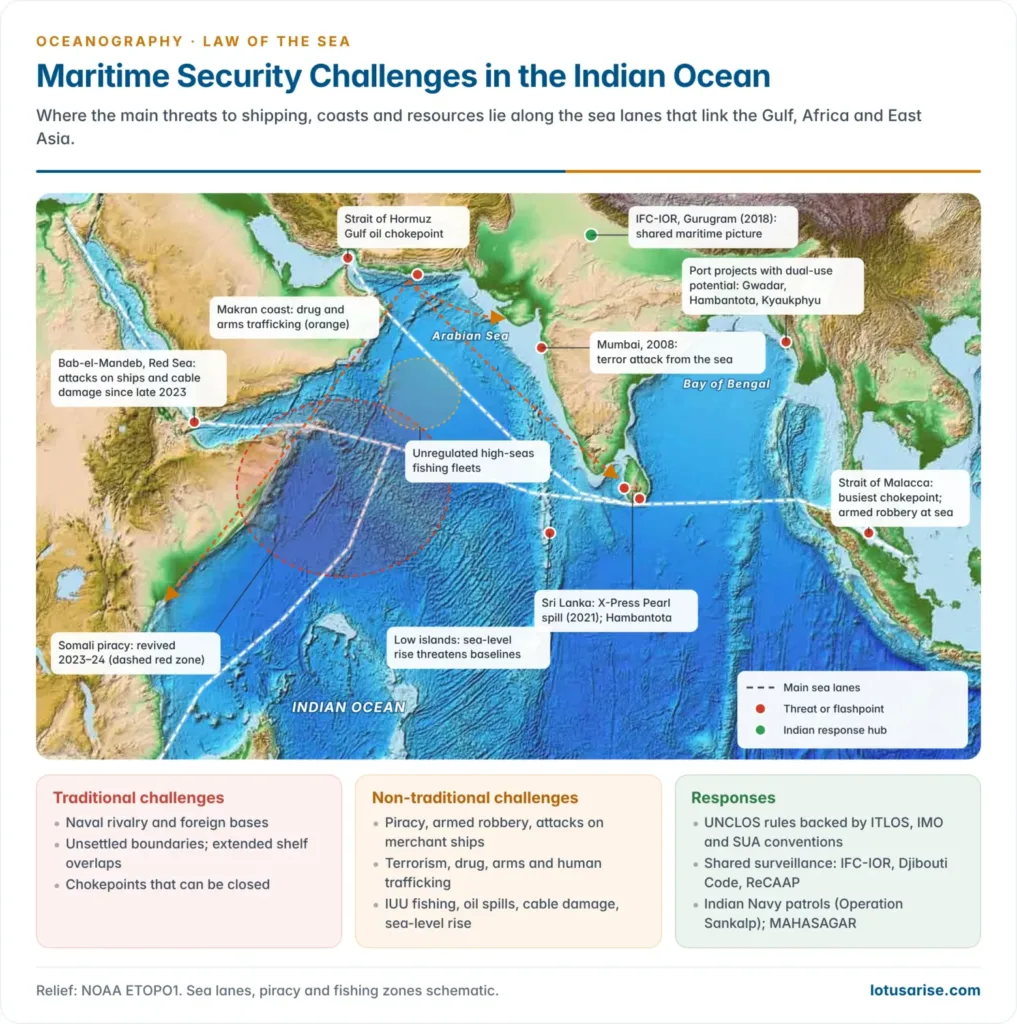
- Maritime security protects lawful trade, resources and people at sea from state and non-state threats. Most of India’s trade by volume moves by sea, so the Indian Ocean Region is central to it.
- UNCLOS is strong on zones but weak on security: it barely addresses terrorism, trafficking or attacks on shipping, and has no enforcement arm.
| Challenge | Recent example | Response |
|---|---|---|
| Piracy and armed robbery | Somali piracy revived in 2023–24; Indian Navy freed MV Ruen and held 35 pirates (March 2024) | Universal jurisdiction (Articles 100–107); Djibouti Code of Conduct; ReCAAP; Operation Sankalp |
| Attacks on merchant shipping | Houthi attacks in the Red Sea and Gulf of Aden since late 2023 | Transit passage and freedom of navigation; naval escorts |
| Terrorism from the sea | Mumbai, 2008 | IMO SUA Convention (1988); coastal radar chain; National Maritime Security Coordinator (2022) |
| Drug, arms and human trafficking | Makran-coast routes to Gujarat, Sri Lanka and East Africa | Contiguous-zone enforcement; boarding by consent; Colombo Security Conclave |
| IUU fishing | Unregulated fleets on the north-western Indian Ocean high seas | FAO Port State Measures Agreement; WTO fisheries-subsidies agreement (in force 2025); BBNJ protected areas |
| Contested zones and rivalry | South China Sea; dual-use ports; survey ships | Compulsory dispute settlement; respect for awards |
| Environmental and climate threats | X-Press Pearl spill off Colombo (2021); low islands losing baselines | Part XII duties; MARPOL; the 2024 ITLOS opinion |
| Undersea cables | Red Sea cable damage (2024) | Cable freedoms (Articles 112–115), but few protection rules |
- Solutions:
- Universal adherence to UNCLOS and to tribunal awards, the precedent India set with Bangladesh.
- Shared maritime domain awareness through the Information Fusion Centre–IOR, Gurugram (2018).
- Regional cooperation through IORA, the Indian Ocean Naval Symposium and MAHASAGAR (2025), the successor to SAGAR.
- Filling legal gaps on cables, autonomous vessels and baselines threatened by sea-level rise, in line with the five principles India set out at the UN Security Council in August 2021.
Evaluation
- Achievements: UNCLOS ended the race for ever-wider claims, created stable zones and a working dispute-settlement system, and made the deep sea bed a common heritage.
- Limits: US non-ratification and selective compliance by major powers; vague terms such as “rocks” and military activity in the EEZ; and a thin security and environmental regime that BBNJ, the climate opinions and the rules on marine pollution are only beginning to fill.
- For India, the Convention secures an EEZ equal to about three-fifths of its land area, a route to an extended shelf and a seat in sea-bed mining, while its consent rule on EEZ exercises keeps it at odds with the naval powers’ reading of the same text.





Enough Lucky to have this website❤
same
Article57
*Breadth of the exclusive economic zone*
The exclusive economic zone shall not extend beyond 200 nautical miles from the baselines from which the breadth of the territorial sea is measured.